Summer fishing is in full swing around Longport, and the backwaters are warming up beautifully, bringing a massive influx of life to the local estuaries. However, anglers must exercise severe caution when navigating the Great Egg Harbor Inlet. While the back bays remain sheltered and highly fishable, the inlet itself can become incredibly treacherous. When a stiff afternoon southerly sea breeze opposes an outgoing tide, it creates steep, stacked waves that can easily swamp a small center console.
If you are operating a vessel under 21 feet, it is highly recommended to stick to the Intracoastal Waterway (ICW) and the protected channels behind Absecon Island on windy days. Always check the marine forecast and tidal charts before heading out. For boaters, the launches in nearby Somers Point offer great access, but be wary of the muddy approach channels during dead low tide. For surfcasters and land-based anglers fishing the Longport jetties, conditions are prime, but wear studded wading boots, as the inlet rocks are currently coated in incredibly slick algae.
🎣Nautrek
Private Beta
J
M
R
100+ anglers on the waitlist
The fishing network where your reputation matters.
Find trusted captains, join real trips with cost splitting, and build your Angler Rank. Your spots stay private — you decide who sees your intel.
Fluke are currently the absolute main event in Atlantic County. As the back-bay water temperatures climb into the optimal feeding range, these aggressive flatfish are actively hunting along the channel edges, sod banks, and shallow drop-offs. The bulk of the legal-sized biomass has moved deep into the estuaries, setting up ambush points to gorge on passing baitfish before they eventually migrate toward the ocean reefs later in the season.
Sleeper Pick: Black Sea Bass
While the vast majority of the local fleet is focused entirely on the fluke drift, the nearshore structure is holding excellent numbers of Black Sea Bass. Many anglers overlook these tasty, hard-fighting bottom dwellers during the summer months, but the local artificial reefs and wrecks just outside the inlet are teeming with them. They provide constant, aggressive rod-bending action, making them the perfect target when the flounder bite lulls during the dreaded slack tide.
Baitfish Report
The back bays are currently loaded with massive schools of spearing (silversides) and peanut bunker. We are also seeing a very healthy amount of mantis shrimp, grass shrimp, and small blue crabs flushing out of the marsh creeks during the falling tide. Because the forage is relatively small right now, your lure profiles should remain slender and compact to match the hatch. White, chartreuse, and natural silver patterns are producing the highest strike rates in the slightly stained bay water.
TACTICAL STRATEGY
Summer Flounder in the Backwaters
Where: Focus your efforts on the channel edges behind Longport, specifically targeting the 8 to 14-foot drop-offs in Risley Channel and the mouth of Broad Creek. During the incoming tide, position your boat's drift to run parallel to the sod banks, dragging your baits right along the contour line. On the outgoing tide, shift your focus to the deeper holes near the Ocean City-Longport Bridge pilings, where baitfish are naturally funneled and forced through the chokepoints.
Lure & Bait: A bucktail-and-teaser combo is absolutely essential for pulling keeper-sized fluke. Tie on a 1/2-ounce to 3/4-ounce white Spro Prime Bucktail as your bottom weight, adjusting the size based on the current speed so you can maintain bottom contact. About 15 inches above that, run a 3/0 baitholder hook as a teaser. Tip both the bucktail and the teaser with 4-inch Berkley Gulp! Swimming Mullets. Chartreuse and Pink Shine are heavily outperforming natural colors, likely because their bright profiles stand out in the turbulent tidal water.
Timing: The last two hours of the incoming tide and the first hour of the outgoing tide provide the cleanest water clarity and the most aggressive feeding windows.
Pro Tip: Keep your rod tip bouncing constantly. Fluke are highly visual predators; a stationary bait dragging lifelessly in the mud will get ignored. A frantically twitching bucktail that kicks up rhythmic puffs of sand will trigger instinctual, aggressive reaction strikes from doormat-sized flatfish.
Black Sea Bass on the Nearshore Reefs
Where: Head out of Great Egg Harbor Inlet and make the run to the Great Egg Reef. This square-mile oasis of structure is loaded with concrete castings, Army tanks, and reef balls. If you have side-scan sonar, look for the Rothenbach II tank barge, which consistently holds large concentrations of sea bass.
Lure & Bait: Drop a standard hi-lo bottom rig tied with 30-pound fluorocarbon leader and 2/0 octopus hooks. Bait your hooks with fresh clam ribbons or squid strips. If you want to weed out the smaller throw-aways, switch to a 2-ounce diamond jig or a slow-pitch jig and work it just a few feet above the wreckage.
Timing: Slack tide is your best friend here. It allows you to maintain a vertical presentation directly over the structure without needing heavy lead to fight the current.
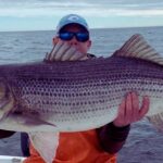
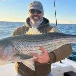
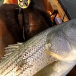
Striped Bass at the Inlet
Where: The rock jetties lining the Great Egg Harbor Inlet and the deep shadow lines of the local toll bridges are holding resident stripers. Avoid the treacherous center channel; instead, work the current seams where the fast-moving inlet water meets the slower, swirling eddies near the rocks.
Lure & Bait: Toss a 5-inch soft plastic paddletail, like a Kettle Creek or Z-Man DieZel MinnowZ, rigged on a 1/2-ounce leadhead. White or pearl colors match the spearing perfectly. If you prefer soaking bait, drifting live spot or live eels through the bridge pilings at night is a highly effective tactic for tempting larger, wary holdover bass.
Timing: Low light is non-negotiable. Dawn, dusk, and the graveyard shift under the bridge lights are your only reliable windows for summer stripers. Once the sun is high and boat traffic increases, the bass will shut down.
Pro Tip: When fishing the inlet rocks, always cast up-current and retrieve your swimbait just fast enough to keep it off the bottom. Let the tide sweep your lure naturally past the strike zones; bass will be facing into the current waiting for stunned bait to be washed directly to them.
REGULATIONS SNAPSHOT
Please note that New Jersey marine regulations are strictly enforced by the DEP. Ensure you are registered with the free NJ Saltwater Recreational Registry Program before casting a line.
Note: Striped Bass anglers may harvest one additional fish between 24 and less than 28 inches if they possess a valid New Jersey Striped Bass Bonus Program (SBBP) permit. Mandatory harvest reporting within 24 hours is required. Furthermore, the use of inline (non-offset) circle hooks is mandatory when fishing for striped bass with bait.
REGIONAL ALTERNATIVE
If the wind is howling out of the south or east, turning the Great Egg Harbor Inlet into a washing machine and making the Longport bays unfishable, do not force a bad situation. Pack up the truck and head inland to the Great Egg Harbor River in Mays Landing.
Where to go: Gaskill Park offers a fantastic, 500-plus yard public bulkhead right in the heart of Mays Landing, providing excellent land-based access with plenty of parking. The river here is highly sheltered from coastal winds and offers a safe, productive alternative.
Target Species: White Perch and holdover Striped Bass.
Tactical Approach: The river at this location features a mix of fresh and brackish water, with a mean depth of 5 feet and several deep holes. Use a simple hi-lo bottom rig baited with fresh bloodworms or grass shrimp to target White Perch in the deeper depressions. For stripers, cast small inline spinners or soak cut bunker near the Route 50 bridge overpass, where the fish funnel toward the dam. The water here is much calmer, ensuring you can salvage a blown-out coastal day with constant, light-tackle action.
Pro Tip: When fishing the Great Egg Harbor River near the bulkhead, look for the deeper holes and channel swings. Perch school up tightly in these depressions during moving water. Once you catch one, stay put and cast right back to the exact same spot, as there are likely dozens more stacked up in that specific hole.
Tight lines!
Editor's Choice: Must-Have Gear
FISHINGSIR Next-Gen Waterproof Chest Waders
★★★★★4.4 (7,370+ reviews)
2-Ply Tech: Upgraded nylon with 2.5x higher density than standard fabrics.
100% Waterproof: Lab-approved intrusion resistance with taped visible seams.
Ultra-Lightweight: Designed for all-day comfort while hunting or fishing.
As an Amazon Associate I earn from qualifying purchases. #ad
Loading forecast...
Live Fishing Conditions: Tides, Weather & Waves
Get real‑time tides, marine weather, swell and solunar activity for each spot so you know exactly when conditions line up for your best chance at a bite.
🎣
Longport NJ
Loading coordinates...
🌤️
WEATHER CONDITIONS
--°F
--°C
Loading...
🌡️
Feels Like--°F--°C
💧
Humidity--%
💨
Wind-- mph-- km/h
🧭
Direction--
📊
Pressure-- inHg-- hPa
☀️
UV Index--
🌊
MARINE CONDITIONS
🌊Wave Height
-- ft
-- m
Loading...
🧭Wave Direction
--°
Loading...
⏱️Wave Period
-- s
Loading...
📈Tide Status
-- ft
-- m
Loading...
🌙
LUNAR & SOLUNAR
🌕
Loading...
Illumination: --%
Major Period--:-- - --:----:-- - --:--
Minor Period--:-- - --:----:-- - --:--
🌅Sunrise--:--
🌇Sunset--:--
📅
24-HOUR FORECAST
Loading fishing conditions...
Fishing Spots Map
🎣
Book a Fishing Charter near Longport NJ Fishing Report Today 🎣
Local guides & charters. Verified captains, instant booking, best price guaranteed.
There was an error loading the map. Please try refreshing the page.
Info
Local Access & Facilities
Longport NJ Pre-Trip Checklist
Local Access & Facilities
Situated at the southern tip of Absecon Island, Longport serves as a strategic convergence zone for anglers targeting the rich waters of the southern New Jersey coast. To the east, the open Atlantic offers surf casting and offshore access, while to the west and south, the nutrient-dense estuary system of the Great Egg Harbor River provides miles of protected backwater channels. This location is defined by its proximity to both the high-energy urban environment of Atlantic City and the pristine, protected wetlands of the Edwin B. Forsythe National Wildlife Refuge.
The atmosphere here shifts rapidly from the manicured residential bulkheads of Longport to the rugged, grassy banks of the intracoastal waterways. For seasoned captains, this area is a logistical hub that balances the convenience of nearby municipal infrastructure with access to wild, scenic river systems designated by the National Park Service. The primary draw here includes migratory striped bass running along the beachfront and summer flounder hunting the ledges of the deep channels feeding into the inlet.
Navigating this fishery requires an understanding of the complex interplay between the developed barrier islands and the protected federal reserves. While the oceanfront offers straightforward surf fishing, the most productive boat access often involves navigating tidal creeks and understanding the specific launch protocols of the local municipal ramps. The following guide details the logistical realities of fishing these waters, from trailer parking strategies to navigating the sensitive ecological zones that make this fishery so productive.
💡 Captain's Tip: Dawn Patrol Logistics
For early risers hitting the dawn bite, note that Tight Lines Bait and Tackle in nearby Somers Point opens at 6:00 AM. Plan your route to stock up on fresh bunker or clams before hitting the ramps, as on-water bait acquisition can be unreliable in the early season.
Access & Getting There
Reaching the Longport fishing grounds typically involves navigating the Garden State Parkway. Anglers towing vessels should utilize Exit 36 to access the Northfield/Margate/Longport area. Traffic on the barrier islands can be dense during the summer months, particularly on weekends. It is advisable to time your arrival for early morning to avoid the congestion associated with beach traffic on the local boulevards. The drive from the mainland crosses tidal wetlands, offering a visual check of the water levels and wind conditions in the back bays before you even reach the launch.
For boaters, the launch situation requires specific local knowledge. The Bass Harbour Boat Ramp, located approximately 3 miles from the center of Longport, and Seaview Dock (2.4 miles away) serve as primary access points for the immediate area. These facilities are generally suitable for trailer boats, but skippers should be mindful of the tide. Low tide can expose mudflats in the approach channels, making navigation tricky for vessels with deeper drafts. The Great Egg Harbor River access point, managed as a recreational area roughly 6.4 miles inland, offers an alternative launch for those specifically targeting the upper river system or seeking shelter from heavy ocean swells.
Parking is a critical logistical component, particularly for those surf fishing or trailering. Ocean City provides several municipal lots just across the bridge, including the Delta Lot, Beta Lot, and Echo Lot. These are located approximately 3.2 to 3.3 miles from the fishing grounds. While these lots are reliable, they do not explicitly advertise dedicated trailer parking, so researching the specific lot dimensions via satellite view or arriving early to secure perimeter spots is recommended. For anglers accessing the northern stretch near Atlantic City, Park Place Parking offers 24-hour access, which is essential for night tides, though it is a standard urban lot.
💡 Captain's Tip: Weather Contingencies
When Northeast winds exceed 15 knots, the inlet at Great Egg Harbor can become treacherous with standing waves. In these conditions, trailering to the Great Egg Harbor River launch allows you to fish the protected leeward banks and scenic river stretches safely, avoiding the dangerous inlet chop.
Facilities & Amenities
The infrastructure around Longport caters to a mix of recreational boaters and serious anglers. The area is well-serviced by specialized tackle shops that understand the local seasonal runs. Tight Lines Bait and Tackle in Somers Point (3.4 miles away) is a staple for local intelligence and gear, operating from 6:00 AM daily (closing times vary between 8:00 PM and 10:00 PM). For those positioned further north or west, Boulevard Bait & Tackle in Ocean View offers another reliable waypoint, though it is a longer drive at roughly 14.4 miles.
The charter fleet in this region is diverse, ranging from back-bay specialists to offshore sportfishers. Moover Fishing Adventures, based just 4.6 miles away in Ocean City, is a notable local operator with a perfect rating, offering 24-hour operational flexibility. For anglers looking for different experiences, Time Out Fishing Charters in Absecon provides access to the northern back bays. It is worth noting that while there are several launch ramps, specific fuel docks are not listed in the immediate ramp data; experienced captains ensure their tanks are topped off at highway gas stations before entering the barrier island grid to avoid premium marina prices or availability issues.
Accommodations for multi-day trips vary significantly by preference. For those seeking comfort close to the action, Marriott's Fairway Villas in Galloway is a high-rated option roughly 9.8 miles away. However, for the dedicated "camp and fish" demographic, the area offers several well-rated campgrounds slightly inland. Ocean Isle Campground (11.6 miles) and Little Oaks Campground (16 miles) provide excellent bases of operation for anglers traveling with RVs or seeking a more rustic atmosphere closer to the river access points.
Key Local Services
Service Name
Type
Distance
Notes
Tight Lines Bait and Tackle
Bait & Tackle
3.4 miles
Opens 6:00 AM. High Rating (4.9).
Moover Fishing Adventures
Charter
4.6 miles
24-hour operation listed. Ocean City based.
Park Place Parking
Parking
6.2 miles
Open 24 hours. Located in Atlantic City.
Time Out Fishing Charters
Charter
8.7 miles
Absecon based. Opens 5:00 AM.
Boulevard Bait & Tackle
Bait & Tackle
14.4 miles
Closed Mon-Thu. Weekend early hours (6:30 AM).
Permits, Regulations & Fees
Fishing in the Longport area places you within the influence of several critical conservation zones, making adherence to regulations paramount. The Edwin B. Forsythe National Wildlife Refuge and the Jacques Cousteau National Estuarine Research Reserve protect vast swaths of the coastal wetlands here. These areas are managed to sustain the Atlantic Flyway's migratory bird populations and the nursery grounds for local fish stocks. Anglers must be vigilant regarding "No Wake" zones and restricted areas, particularly near nesting grounds within the refuge boundaries.
The Great Egg Harbor River is designated as a National Wild and Scenic River. While recreational fishing is a celebrated activity here, it is administered by local jurisdictions in partnership with the National Park Service. This designation emphasizes the preservation of the river's free-flowing condition and water quality. Consequently, regulations regarding waste disposal and habitat disturbance are strictly enforced. There are no specific federal fishing permits required beyond the standard state licenses, but awareness of the overlaying federal protections is essential for legal compliance.
Fishing regulations, including size and bag limits for species like Summer Flounder, Striped Bass, and Tautog, are managed by the State Fishing Agency. It is the angler's responsibility to possess a valid New Jersey Saltwater Recreational Registry Program (NJSRRP) registration. Be aware of seasonal closures, specifically in the Holgate Wilderness Area of the Forsythe Refuge, which is closed to all entry from September 1 through March 31 to protect nesting birds and resting migrants. Beach buggy access in permitted areas often requires a separate municipal permit, such as those issued by Long Beach Township for areas further north.
💡 Captain's Tip: Protected Zones
The Holgate Wilderness Area is strictly off-limits from September 1 to March 31. Even surf casters must respect this closure. Always check current refuge maps before planning a shoreline expedition in the fall.
Events & Seasonal Information
The biological rhythms of the Longport area are dictated by the seasonal migrations along the Atlantic coast. The Great Egg Harbor River and the surrounding estuarine reserves serve as a massive nursery, meaning that spring and early summer see an explosion of baitfish that draws predators into the shallows. The water conditions in the back bays warm faster than the ocean, often kicking off the flounder season earlier in the creeks and thoroughfares behind Longport before the bite moves to the ocean wrecks.
While specific tournament dates vary annually, the region is famous for its summer billfish runs offshore and the autumn striped bass migration. The presence of the Jacques Cousteau National Estuarine Research Reserve highlights the ecological importance of this area; the health of the estuary directly correlates to the quality of the game fishing. Anglers should monitor reports from the Forsythe Refuge regarding bird migrations, as the arrival of specific seabirds often coincides with the presence of massive schools of baitfish, signaling the start of the prime fall run.
Timing your trips requires attention to the daily wind patterns. During the summer, the "sea breeze" effect often kicks in by late morning, turning the open bays choppy. Experienced locals know that the hours between dawn and 10:00 AM offer the calmest surface conditions for topwater action in the sedge islands. Conversely, late afternoon outgoing tides can be excellent for drifting bait near the inlet mouth as warm water flushes out of the back bays.
Contact Information & Resources
For official information regarding access and regulations within the federal reserves, anglers should contact the managing agencies directly. The Edwin B. Forsythe National Wildlife Refuge headquarters can be reached at 609-652-1665 or via email at forsythe@fws.gov. For inquiries specific to the river system, the Great Egg Harbor National Scenic and Recreational River is administered in partnership with the National Park Service, and local inquiries can be directed to the county contacts provided in the facility data.
Safety on the water is the skipper's primary responsibility. In the event of an emergency, the Ocean City Beach Patrol and local Coast Guard stations monitor standard marine VHF channels. Always file a float plan, especially when venturing into the vast marshlands where cell service can be spotty and landmarks are easily confused. Self-reliance is key, particularly when navigating the shifting shoals of the inlet and the unlit channels of the wildlife refuge at night.
For precise locations of the boat ramps, real-time tide data, and the exact boundaries of the protected zones mentioned above, consult the live dashboard and interactive maps below.
Our spot reports combine data-driven forecasts with curated local information. The forecast is generated by our proprietary Fishing Score algorithm (0–100%), which analyzes real-time data from Open-Meteo API, validated against NOAA CO-OPS tide gauges and USGS water-monitoring stations. The model weights tide dynamics (35%), wave energy (25%), wind patterns (20%) and time of day (20%)—factors shown to influence fish feeding behavior through marine-biology research and decades of charter log data.
Access, facilities and services information for each fishing spot is sourced from official datasets such as Recreation.gov (RIDB), state park & wildlife agencies, and geospatial providers like Google Maps. These sections undergo scheduled re-validation every 3–6 months to ensure that boat ramps, park access, contact details and local services remain accurate.
Narrative sections (catches, seasonal behavior, local tips) are synthesized from these data sources and refined following the Fishing Reports Today editorial guidelines, combining bibliographic research from ichthyology and oceanography with expert angler experience. Our team reviews reports on a regular basis, while the forecast model itself updates every 6 hours for real-time accuracy.
⚠️ Important: Always verify current local regulations, access restrictions and weather conditions before fishing. These reports are intended as a planning aid, not a guarantee of catches or safety. When in doubt, contact local authorities or park managers listed on the page.
To provide the best experiences, we use technologies like cookies to store and/or access device information. Consenting to these technologies will allow us to process data such as browsing behavior or unique IDs on this site. Not consenting or withdrawing consent, may adversely affect certain features and functions.
Functional Always active
The technical storage or access is strictly necessary for the legitimate purpose of enabling the use of a specific service explicitly requested by the subscriber or user, or for the sole purpose of carrying out the transmission of a communication over an electronic communications network.
Preferences
The technical storage or access is necessary for the legitimate purpose of storing preferences that are not requested by the subscriber or user.
Statistics
The technical storage or access that is used exclusively for statistical purposes.The technical storage or access that is used exclusively for anonymous statistical purposes. Without a subpoena, voluntary compliance on the part of your Internet Service Provider, or additional records from a third party, information stored or retrieved for this purpose alone cannot usually be used to identify you.
Marketing & Affiliates
The technical storage or access is required to create user profiles to send advertising, or to track the user on a website or across several websites for similar marketing purposes, including affiliate tracking for products recommended in our reports.


Leave a Reply