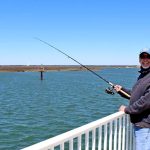
Current seasonal conditions are prime for anglers hitting both the Delaware Bay and the Atlantic side. Water temperatures are steadily climbing into the optimal feeding zones for our late spring migratory species, triggering aggressive feeding behaviors across the board. The weather patterns are stabilizing, offering extended windows of highly fishable seas.
Safety Advisory: The Cape May Rips and the confluence of the Delaware Bay and the Atlantic Ocean are currently experiencing heavy tidal flows due to recent moon phases. Small boat operators should exercise extreme caution when navigating the rips during an outgoing tide against a strong prevailing wind, as standing waves can build rapidly and unpredictably. Always monitor the marine forecast before passing the jetties.
🎣Nautrek
Private Beta
J
M
R
100+ anglers on the waitlist
The fishing network where your reputation matters.
Find trusted captains, join real trips with cost splitting, and build your Angler Rank. Your spots stay private — you decide who sees your intel.
Weather Impact Assessment: Warming afternoon sun is heating up the shallow mudflats in the back bays, creating excellent late-day temperature spikes that are essential for turning on the flounder bite. Offshore, light variable winds are allowing the fleet to easily reach the 20-mile wrecks without taking a beating.
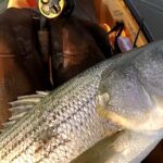
With the recent opening of the black sea bass season, the inshore wrecks and artificial reefs are absolutely on fire. Anglers are reporting near-instant hookups upon hitting the bottom, with a fantastic ratio of keepers to throwbacks. Meanwhile, the Delaware Bay black drum bite is in full swing. Massive boomers pushing the 80-pound mark are being hauled over the gunwales by the fleet anchoring over the bay shoals.
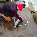
Sleeper Pick: Weakfish (Tide Runners)
Often overlooked by anglers relentlessly chasing stripers or fluke, the weakfish have made a quiet but incredibly solid appearance. They are staging along the rockpiles, jetty structures, and the deeper holes near the ferry terminal, offering fantastic light-tackle action for those willing to downsize their gear.
Baitfish Report:
Massive schools of adult Atlantic menhaden (bunker) are pushing through the Delaware Bay and hugging the coastal beaches. Accompanying this finfish migration is an abundance of shedder crabs and surf clams churned up by the rolling surf. Predatory fish are keyed in on these high-protein forage options, so matching your presentations to bunker profiles and clam scents is absolutely critical for success.
3. TACTICAL STRATEGY
Black Drum & Striped Bass
Where: For drum, anchor up on the New Jersey side of the Delaware Bay—specifically around Pinters Shoal, the Tussey's, or the 60-foot sloughs. For surf stripers, target the Poverty Beach surf zone or the bayside shores near the North Cape May beaches.
Bait: Fresh, un-shucked surf clams are outperforming everything else for drum. Crack the shell slightly to let the scent bleed down-tide. For stripers on the bayside beaches, fresh bunker chunks or salted clams are the ticket.
Rigging: Use a fish-finder rig with a short, heavy fluorocarbon leader (60 to 80-pound test) and an 8/0 to 10/0 inline circle hook for drum. You will need 4 to 8 ounces of lead to hold bottom in the bay currents.
Timing: The incoming tide at first light is producing the best striper action, while the drum are feeding heavily during the nighttime tidal swings, especially around the new and full moons.
Black Sea Bass
Where: The Old Grounds (roughly 18 miles south of the Cape May Inlet in 65 to 90 feet of water) and the local inshore artificial reefs. Look for the yellow DB buoy to locate the general fleet area, then use your electronics to scan for isolated ballast rock piles and old mussel beds.
Lure & Bait: Traditional high-low bottom rigs tipped with fresh squid strips, salted clam, or green crabs are highly effective. For artificials, a 2-ounce to 4-ounce diamond jig with a red tube tail will quickly weed through the aggressive smaller throwbacks to find the knotheads holding tighter to the structure.
Weakfish & Summer Flounder
Where: Target weakfish off Higbee's Beach and along the Cape May jetties. For flounder, focus on the 8 to 12-foot drop-offs behind West Wildwood, the Grassy Sound channels, and the sun-baked mudflats on an outgoing tide.
Lure & Color: For weakfish, float a bloodworm or work a 1/2-ounce pink bucktail tipped with a pink Zoom trick worm. For flounder, use a 3/8-ounce jig head paired with a 4-inch Berkley Gulp Swimming Mullet. Nuclear Chicken or Chartreuse are the top producing colors for back-bay flounder in stained water.
Timing: Flounder fishing is best during the late afternoon outgoing tide, as the sun-warmed water from the shallows gets pulled across the drop-offs, activating the fish.
Pro Tip:When targeting weakfish on the jetties, keep your drag exceptionally loose. They are known as "trout" for a reason—their paper-thin mouths will easily tear if you try to muscle them in against the sweeping inlet currents.
4. REGULATIONS SNAPSHOT
Compliance is strictly enforced by the New Jersey Division of Fish and Wildlife. Keep these current regulations in mind before boxing your catch. Fines are steep and ignorance of the law is not an excuse.
Inline non-offset circle hooks are mandatory when fishing with natural bait.
Summer Flounder (Delaware Bay)
17 inches
3 per angler
Applies west of the COLREGS line delineating the bay from the ocean.
Summer Flounder (Ocean & Back Bays)
18 inches
3 per angler
Do not retain racks (carcasses) from previous trips on your vessel.
Black Sea Bass
12.5 inches
Varies by season
Season is currently OPEN. Check DFW for specific mid-season bag limit shifts.
Pro Tip:New Jersey does not require a paid saltwater fishing license, but you MUST register for the free NJ Saltwater Recreational Registry Program before casting a line. Charter boat patrons are typically covered by the captain's registry, but surf and private boat anglers must have their own printed copy on hand.
5. REGIONAL ALTERNATIVE
Backup Plan A: The Wildwood Backwaters
If stiff northwest winds blow out the Delaware Bay and make the ocean inlets treacherous, trailer your vessel north to the protected Intracoastal Waterway (ICW) behind Wildwood and North Wildwood. Access the water via the Grassy Sound Marina ramps. Here, you can escape the wind and target early-season summer flounder and cocktail bluefish. Drift the channel edges on a falling tide, bouncing 3/8-ounce bucktails tipped with Gulp along the sod banks. The water here warms up faster than the ocean, often triggering a more aggressive bite when the main bay shuts down.
Backup Plan B: Land-Based Action at Cape May Canal
If you do not have a vessel or the weather is entirely unfishable for boating, the banks of the Cape May Canal offer excellent shore-based opportunities. Park near the ferry terminal and walk the rock-lined banks. Casting heavy spoons or chunking fresh bunker into the deep, fast-moving water of the canal can yield impressive striped bass and wandering bluefish. The high banks provide excellent shelter from prevailing ocean winds, making it a reliable fallback when the beaches are unfishable.
Pro Tip:When shore fishing the canal, bring a long-handled drop net. The banks are steep and rocky, making it nearly impossible to land a heavy striper by hand without risking injury or losing the fish.
Tight lines!
Editor's Choice: Must-Have Gear
FISHINGSIR Next-Gen Waterproof Chest Waders
★★★★★4.4 (7,370+ reviews)
2-Ply Tech: Upgraded nylon with 2.5x higher density than standard fabrics.
100% Waterproof: Lab-approved intrusion resistance with taped visible seams.
Ultra-Lightweight: Designed for all-day comfort while hunting or fishing.
As an Amazon Associate I earn from qualifying purchases. #ad
Loading forecast...
Live Fishing Conditions: Tides, Weather & Waves
Get real‑time tides, marine weather, swell and solunar activity for each spot so you know exactly when conditions line up for your best chance at a bite.
🎣
Cape May
Loading coordinates...
🌤️
WEATHER CONDITIONS
--°F
--°C
Loading...
🌡️
Feels Like--°F--°C
💧
Humidity--%
💨
Wind-- mph-- km/h
🧭
Direction--
📊
Pressure-- inHg-- hPa
☀️
UV Index--
🌊
MARINE CONDITIONS
🌊Wave Height
-- ft
-- m
Loading...
🧭Wave Direction
--°
Loading...
⏱️Wave Period
-- s
Loading...
📈Tide Status
-- ft
-- m
Loading...
🌙
LUNAR & SOLUNAR
🌕
Loading...
Illumination: --%
Major Period--:-- - --:----:-- - --:--
Minor Period--:-- - --:----:-- - --:--
🌅Sunrise--:--
🌇Sunset--:--
📅
24-HOUR FORECAST
Loading fishing conditions...
Fishing Spots Map
🎣
Book a Fishing Charter near Cape May Fishing Report Today 🎣
Local guides & charters. Verified captains, instant booking, best price guaranteed.
There was an error loading the map. Please try refreshing the page.
Info
Local Access & Facilities
The Geographic Funnel: A Strategic Overview
Cape May represents more than just the southern termination of the Garden State Parkway; for the serious angler, it is a biological funnel of immense strategic importance. Situated where the Atlantic Ocean meets the Delaware Bay, this region creates a unique choke point for migratory species. The topography here is defined by the Cape May National Wildlife Refuge, a critical habitat that supports a vast array of wildlife, including numerous fish and shellfish populations. The dynamic between the open ocean swells and the estuarine waters of the bay creates a diverse fishery that demands respect and navigational competence.
The atmosphere in Dennis Township and the surrounding Cape May area shifts dramatically depending on your specific location. To the east, you have the "glitzy" history of the Jersey Shore, exemplified by the Doo Wop architecture of the Wildwoods. However, the fishing grounds themselves are often bordered by quiet, protected salt marshes and the rugged coastlines of the Delaware Bay. This is not merely a manicured harbor environment; it is a complex ecosystem where the Cape May Peninsula's unique configuration concentrates life, forcing migratory species to linger and feed before crossing the 12-mile stretch of the Delaware Bay.
For the expert angler, this location offers access to both back-bay quiet water and open ocean conditions. The area is heavily influenced by the seasonal migrations that funnel south to Cape May Point. Understanding the interplay between the protected refuge lands and the accessible waterways is key to unlocking the potential of this fishery.
Access & Getting There
Reaching the prime fishing grounds in Cape May and Dennis Township requires navigating the primary artery of the Jersey Shore: the Garden State Parkway. For those towing vessels, the standard approach involves taking Exit 10 toward Cape May Court House. From there, the route follows Route 9 South to Hand Avenue and eventually connects to State Highway 47 (Delsea Drive). This route is generally trailer-friendly, though traffic can become heavy during peak summer weekends. The final approach to the Refuge access at Kimbles Beach Road involves a sharp turn, so captains with larger center consoles should be mindful of their turning radius.
💡 Captain's Tip: The Bay Crossing
The geography of the Cape May Peninsula forces a 12-mile water crossing at the Delaware Bay. Experienced skippers know that migratory species—and anglers—often linger here waiting for favorable winds. Do not attempt to cross or fish the open bay mouth when wind opposes the tide, as the conditions can deteriorate rapidly into dangerous chop.
Boat launch options in the immediate vicinity vary in quality and capacity. The 57th Street Boat Launch is a primary access point located approximately 7.4 miles from the central hub. For those looking for shore access or launching kayaks, the Cape May National Wildlife Refuge provides specific entry points, though vehicle access is strictly regulated to protect the sensitive marsh habitat. When launching, always have a backup plan; during the fall migration, the most popular ramps can reach capacity before sunrise.
Parking requires a strategic approach, particularly for those with trailers. The Stone Harbor Public Parking lot, located roughly 8.7 miles away on 2nd Avenue, is rated highly and noted for being a large lot, making it a likely candidate for accommodating boat trailers. In contrast, parking closer to the historic districts or the Caribbean Motel area on Ocean Avenue can be tight and is often geared towards passenger vehicles. Always verify trailer permitting signage, as municipal rules change frequently along the coast.
💡 Captain's Tip: Trailer Logistics
While street parking is common in the off-season, summer restrictions are fierce. The Stone Harbor Public Parking lot is your safest bet for trailer storage if you are not staying at a property with dedicated marine parking. Always scout the lot entrance on Google Maps satellite view before committing a 30-foot rig to a turn.
Cape May Pre-Trip Checklist
Facilities & Amenities
The infrastructure surrounding Cape May is a mix of high-end historic tourism and gritty, functional marine services. For bait and tackle, the landscape is decentralized. Boulevard Bait & Tackle in Ocean View is the closest dedicated shop, sitting just 3.6 miles from the core area. However, logistical planning is essential here: this shop is closed Monday through Thursday, opening at 6:30 AM on Fridays and weekends. For mid-week trips, you must travel further to Tight Lines Bait and Tackle in Somers Point (14.4 miles) or Hands Too Bait and Tackle in Cape May proper (16.1 miles).
Local Marine Service Providers
Facility Name
Distance
Specialization / Notes
Boulevard Bait & Tackle
3.6 mi
Closest option. Closed Mon-Thu. Opens 6:30 AM Fri-Sun.
Tight Lines Bait and Tackle
14.4 mi
Reliable daily hours (6:00 AM - 8:00 PM). Good for mid-week supplies.
Hands Too Bait and Tackle
16.1 mi
Located near the Cape May harbor mouth. Open daily from 6:00 AM.
Big Dave's Tackle
13.3 mi
Early riser choice. Opens at 5:00 AM daily.
The charter fleet in this region is robust, reflecting the quality of the fishery. Salty Grunt Sportfishing operates out of Cape May (Ocean Dr), roughly 16 miles south, positioning them perfectly for Delaware Bay and Atlantic sorties. For those looking to depart from further north, Moover Fishing Adventures and The Grateful Fred Charters run out of Ocean City. It is important to note that while there are "nearby" charters, the driving distance between the Refuge area in Dennis and the marinas in Cape May or Ocean City can be 20-30 minutes, so factor this into your dawn patrol commute.
Accommodations range from the rustic to the retro-chic. For anglers prioritizing proximity to the launch and a place to park a rig, Jersey Shore Haven Airstream Park and Little Oaks Campground in Cape May Court House offer the closest lodging, within 2 miles of the center. On the other end of the spectrum is the Caribbean Motel in Wildwood Crest. Listed on the National Register of Historic Places, this "Doo Wop" era motel offers a unique aesthetic experience with plastic palm trees and neon lights, though it is located 13.8 miles away on the barrier island, which may add travel time to inland launches.
💡 Captain's Tip: Fuel & Ice Gaps
Note that the immediate vicinity of the Cape May National Wildlife Refuge in Dennis Township lacks direct marina fuel docks. You are advised to fuel up your vessel and cooler on Route 9 or Route 47 (Delsea Drive) before turning onto the smaller access roads like Kimbles Beach Road.
Permits, Regulations & Fees
Fishing within the Cape May region is governed by a dual layer of regulations: state-level mandates and specific federal refuge rules. The Cape May National Wildlife Refuge allows fishing, but it is strictly controlled to ensure the conservation of the migratory bird habitat. The refuge was established specifically to protect the critical habitat that supports over 317 bird species and 42 mammal species. As such, access to shoreline fishing spots may be restricted seasonally or geographically to prevent disturbance to nesting or resting wildlife.
All anglers must adhere to the regulations set forth by the State Fishing Agency. This includes size limits, bag limits, and seasonal closures which are strictly enforced. Because this area is a "Flagship Project" of the North American Waterfowl Management Plan and a Wetland of International Importance, environmental stewardship is not just a suggestion—it is a legal requirement. Do not discard monofilament or tackle in these waters; the impact on the high concentration of wildlife is immediate and severe.
There is generally no specific federal permit required for recreational fishing entry into the Refuge, but visitors should always check the "ridb_scan" sources or local signage for the most current permit requirements, as special use permits may apply for commercial activities or specific access methods.
Events & Seasonal Information
The biological rhythm of Cape May is dictated by migration. The fall season is the undisputed peak for biological activity. As the Refuge description notes, the peninsula's configuration concentrates songbirds, raptors, and woodcock during their fall migration. For the angler, this coincides with the "mullet run" and the southward migration of striped bass and bluefish, which often trap bait against the structure of the bay and beachfront.
Weather patterns here are distinct. The area faces 12 miles of open water at the Delaware Bay. In the summer, the prevailing winds can create a calm morning followed by a choppy afternoon sea breeze. However, it is the transition seasons—spring and fall—where the weather dictates the fishing. Migrants (both avian and aquatic) will linger in the area to rest and feed until favorable winds allow them to cross the Bay. Experienced captains watch for these weather windows; a shift in wind direction can trigger a massive feed, turning a quiet day into a world-class event.
Contact Information & Resources
For the most accurate and up-to-date information regarding access to the Refuge and current conditions, direct communication with the managing agencies is recommended. Self-reliance is key when fishing the backwaters or the bay, as cell service can be spotty in the salt marshes.
Cape May National Wildlife Refuge: 609-463-0994 (Email: capemay@fws.gov)
Safety Note: Always check weather and ocean conditions before fishing. The Delaware Bay can be unforgiving. Wear appropriate footwear when accessing shore points to protect against sharp shells and debris in the marsh mud.
For precise locations of the boat ramps, bait shops, and real-time weather conditions discussed above, consult the live dashboard and interactive maps below.
Our spot reports combine data-driven forecasts with curated local information. The forecast is generated by our proprietary Fishing Score algorithm (0–100%), which analyzes real-time data from Open-Meteo API, validated against NOAA CO-OPS tide gauges and USGS water-monitoring stations. The model weights tide dynamics (35%), wave energy (25%), wind patterns (20%) and time of day (20%)—factors shown to influence fish feeding behavior through marine-biology research and decades of charter log data.
Access, facilities and services information for each fishing spot is sourced from official datasets such as Recreation.gov (RIDB), state park & wildlife agencies, and geospatial providers like Google Maps. These sections undergo scheduled re-validation every 3–6 months to ensure that boat ramps, park access, contact details and local services remain accurate.
Narrative sections (catches, seasonal behavior, local tips) are synthesized from these data sources and refined following the Fishing Reports Today editorial guidelines, combining bibliographic research from ichthyology and oceanography with expert angler experience. Our team reviews reports on a regular basis, while the forecast model itself updates every 6 hours for real-time accuracy.
⚠️ Important: Always verify current local regulations, access restrictions and weather conditions before fishing. These reports are intended as a planning aid, not a guarantee of catches or safety. When in doubt, contact local authorities or park managers listed on the page.
To provide the best experiences, we use technologies like cookies to store and/or access device information. Consenting to these technologies will allow us to process data such as browsing behavior or unique IDs on this site. Not consenting or withdrawing consent, may adversely affect certain features and functions.
Functional Always active
The technical storage or access is strictly necessary for the legitimate purpose of enabling the use of a specific service explicitly requested by the subscriber or user, or for the sole purpose of carrying out the transmission of a communication over an electronic communications network.
Preferences
The technical storage or access is necessary for the legitimate purpose of storing preferences that are not requested by the subscriber or user.
Statistics
The technical storage or access that is used exclusively for statistical purposes.The technical storage or access that is used exclusively for anonymous statistical purposes. Without a subpoena, voluntary compliance on the part of your Internet Service Provider, or additional records from a third party, information stored or retrieved for this purpose alone cannot usually be used to identify you.
Marketing & Affiliates
The technical storage or access is required to create user profiles to send advertising, or to track the user on a website or across several websites for similar marketing purposes, including affiliate tracking for products recommended in our reports.


Leave a Reply