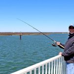
The spring transition is in full swing across the South Jersey coast, making this a highly tactical and rewarding time to fish Ocean City. The current verdict is a definitive GO for the sheltered back bays, tidal creeks, and inlets. However, I issue a strict CAUTION for offshore wrecks and exposed oceanfronts. Unpredictable spring ground swells and stiff coastal breezes can make the open ocean volatile, and freezing spray remains a slight risk on the coldest mornings. Water temperatures in the estuaries are steadily climbing into the upper 50s and low 60s, breathing life into the shallow mudflats and triggering heavy feeding activity. Anglers should prioritize safety by monitoring the wind forecast closely; if the breeze kicks up heavily from the east or northeast, the backwaters will be your safest, most comfortable, and most productive sanctuary.
SPECIES INTEL
Primary Targets: Striped Bass and Summer Flounder
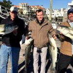
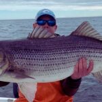
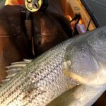
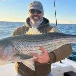
The back bay striped bass run is currently the main event. Both resident holdovers and fresh migratory fish are aggressively feeding around bridge stanchions, sod banks, and inlet mouths. We are seeing a healthy mix of schoolies and slot-sized fish pushing through the tidal thoroughfares. Simultaneously, the summer flounder (fluke) season is officially underway, and the flatties have pushed into the shallow, sun-warmed channels to feed. These early-season flounder are hungry and highly concentrated in specific depth zones, offering excellent light-tackle opportunities.
Sleeper Pick: Black Drum and Black Sea Bass
Often completely overshadowed by the striped bass hysteria, black drum are actively cruising the surf line and the deeper holes inside Corson's Inlet. These heavyweights offer incredible battles for surfcasters and are currently taking baits with authority. Additionally, with the black sea bass season recently opening, nearshore structures like the Great Egg Reef and local wrecks are holding excellent numbers of knotheads for those with a favorable marine forecast to make the short run offshore.
🎣Nautrek
Private Beta
J
M
R
100+ anglers on the waitlist
The fishing network where your reputation matters.
Find trusted captains, join real trips with cost splitting, and build your Angler Rank. Your spots stay private — you decide who sees your intel.
The local estuaries are currently holding dense clouds of early-season forage. Match your artificial presentations to these smaller profiles to trigger reaction strikes from predatory fish that are dialed into this specific spring menu. Current primary forage includes:
Spearing (Silversides): Found schooling heavily along the sod banks and bridge pilings.
Grass Shrimp: Swept out of the marsh creeks during the outgoing tide.
Peanut Bunker: Early pushes are starting to show in the warmer, shallow back bays.
Crustaceans: Green crabs and Asian shore crabs are highly active around the inlet rock piles, providing prime forage for drum and early tautog.
TACTICAL STRATEGY
Where to Deploy
For summer flounder, focus your efforts around the 9th Street Bridge complex. The locally known "Beer Pier" on the Somers Point side offers excellent land-based access to the deep, 30-foot waters of Ship Channel. The mid-bridge piers give you a direct shot at Elbow Channel and Rainbow Channel. Boat anglers should target the 4 to 8-foot sandbar drop-offs in Elbow Channel, drifting parallel to the ledge. For striped bass and black drum, the beachfront at Corson's Inlet is the premier zone. Inside the inlet, target the sod banks and current seams where water funnels out of the marsh.
Pro Tip: When fishing the 9th Street Bridge piers for flounder, cast up-current and let your rig bounce naturally along the bottom as it sweeps past the pilings. Most strikes happen right on the drop-off edge as the bait falls into deeper water.
Lure and Color Selection
When targeting stripers at night around the bridge lights or inlet mouths, throw 5-inch to 6-inch glide baits and Daiwa SP Minnows. In clear water, opt for Bone or Ghost patterns; in stained water or under the cover of darkness, Blurple (Black/Purple) is unmatched. For flounder, a 3/8oz to 1/2oz bucktail tipped with a 4-inch Gulp! Swimming Mullet is the gold standard. Chartreuse and Pink Shine are the top producing colors for the slightly stained back bay waters.
Bait Presentation
If you are soaking bait for black drum or stripers in the surf, fresh shucked clams on a standard fish-finder slide rig are outperforming everything else. Ensure your bait is secured with elastic bait thread so it can withstand the turbulence of the surf zone. For back bay flounder, drifting live minnows (killies) or long, pennant-shaped strip baits on a standard high-low bottom rig will produce consistent limits. Always use a 20lb to 30lb fluorocarbon leader to prevent bite-offs from aggressive bluefish that are starting to mix in.
Timing the Bite
The outgoing tide is the most critical window during the spring transition. As the water drops, it pulls bait and sun-warmed water off the shallow mudflats and funnels it into the deeper channels, triggering heavy feeding windows for all species.
Pro Tip: Focus your backwater efforts on the late afternoon outgoing tide. The sun has had all day to warm the shallow mudflats, and that receding warm water will turn sluggish fish into highly aggressive feeders.
REGULATIONS SNAPSHOT
Before heading out, ensure you are compliant with the current New Jersey marine regulations for our primary target species. Note: Always double-check local postings as mid-season adjustments can occur.
Species
Minimum Size
Bag Limit
Season Status
Striped Bass
28" to 31" Slot
1 per angler
Open (Marine Waters)
Summer Flounder (Fluke)
18"
3 per angler
Open
Black Sea Bass
12.5"
10 per angler
Open (Spring Segment)
Bluefish
No Minimum
5 per angler (Private)
Open
Black Drum
16"
3 per angler
Open
REGIONAL ALTERNATIVE
Great Egg Harbor River System
If the coastal winds are howling, the ground swell is up, and the main inlets are completely blown out, do not cancel your trip—retreat upriver. The Great Egg Harbor River and the neighboring Tuckahoe River offer miles of highly sheltered water that remains incredibly productive during the spring months. The dense tree lines and winding marsh banks block heavy winds, providing a glass-calm surface even when the ocean is churning.
Alternative Tactics
In these river systems, target white perch and holdover striped bass. Focus your sonar on the deeper holes (ranging from 15 to 25 feet) located on the outside bends of the river, as well as the steep sod banks during a high tide. A simple high-low rig baited with bloodworms or grass shrimp is highly effective for filling a cooler with massive white perch. For the river stripers, scale down your tackle. Casting 1/4oz leadheads paired with 3-inch paddletails along the shadow lines of the Route 50 bridge or the deeper creek mouths will entice steady action. Access is readily available at several municipal boat ramps and shoreline parks along the river corridor, making this an easy and stress-free audible to call.
Pro Tip: When targeting white perch in the deep river holes, use small pieces of bloodworm on a size 4 or 6 baitholder hook. Keep your bait moving slightly by slowly lifting and dropping your rod tip to draw their attention in the darker, tannin-stained water.
Tight lines!
Editor's Choice: Must-Have Gear
FISHINGSIR Next-Gen Waterproof Chest Waders
★★★★★4.4 (7,370+ reviews)
2-Ply Tech: Upgraded nylon with 2.5x higher density than standard fabrics.
100% Waterproof: Lab-approved intrusion resistance with taped visible seams.
Ultra-Lightweight: Designed for all-day comfort while hunting or fishing.
As an Amazon Associate I earn from qualifying purchases. #ad
Loading forecast...
Live Fishing Conditions: Tides, Weather & Waves
Get real‑time tides, marine weather, swell and solunar activity for each spot so you know exactly when conditions line up for your best chance at a bite.
🎣
Ocean City NJ
Loading coordinates...
🌤️
WEATHER CONDITIONS
--°F
--°C
Loading...
🌡️
Feels Like--°F--°C
💧
Humidity--%
💨
Wind-- mph-- km/h
🧭
Direction--
📊
Pressure-- inHg-- hPa
☀️
UV Index--
🌊
MARINE CONDITIONS
🌊Wave Height
-- ft
-- m
Loading...
🧭Wave Direction
--°
Loading...
⏱️Wave Period
-- s
Loading...
📈Tide Status
-- ft
-- m
Loading...
🌙
LUNAR & SOLUNAR
🌕
Loading...
Illumination: --%
Major Period--:-- - --:----:-- - --:--
Minor Period--:-- - --:----:-- - --:--
🌅Sunrise--:--
🌇Sunset--:--
📅
24-HOUR FORECAST
Loading fishing conditions...
Fishing Spots Map
🎣
Book a Fishing Charter near Ocean City NJ Fishing Report Today 🎣
Local guides & charters. Verified captains, instant booking, best price guaranteed.
There was an error loading the map. Please try refreshing the page.
Info
Local Access & Facilities
Introduction
Ocean City, New Jersey, presents a unique duality for the serious angler. While often recognized as a manicured family resort destination, the surrounding waters offer access to some of the most biologically diverse estuarine systems on the Eastern Seaboard. Situated between the Atlantic Ocean and the extensive back-bay networks of the Great Egg Harbor River, this location serves as a critical intercept point for migratory species along the Atlantic Flyway. The environment here is defined by a complex interplay of tidal wetlands, shallow coves, and salt marshes, providing rich feeding grounds that attract seasoned captains looking for productive inshore water.
The atmosphere shifts rapidly from the bustling boardwalk to the solitude of the protected wetlands just miles away. To the north and west, the influence of the Edwin B. Forsythe National Wildlife Refuge creates a protected nursery for marine life, ensuring a steady biomass of baitfish and shellfish. For the boat captain, this area requires navigating a mix of open ocean swells and intricate, shallow channels where knowledge of the tides is paramount. The bottom topography varies from shifting sandy shoals near the inlets to the nutrient-rich mudflats of the river systems.
Anglers targeting this region are typically focused on the seasonal migrations that hug the Jersey Shore. The connectivity between the Great Egg Harbor system and the open ocean allows for a variety of fishing styles, from surf casting off the barrier island to technical shallow-water boating in the thoroughfares. Understanding the specific logistics of launching and parking in this high-traffic coastal town is the difference between a smooth dawn patrol and a frustrated morning on land.
Access & Getting There
Reaching the prime fishing grounds in Ocean City requires navigating a mix of local municipal roads and major arteries like the Garden State Parkway. For those trailering boats, the primary access point to the backwater systems is the Great Egg Harbor River launch area, located approximately 4.4 miles from the city center. This site is part of a designated National Wild and Scenic River system. Traffic on the barrier island can be heavy during the summer season, particularly on Atlantic Avenue and Moorlyn Terrace, so plan your transit times accordingly to avoid the mid-morning congestion.
Parking strategies in Ocean City require careful attention to municipal regulations. The area is serviced by several municipal lots, specifically the Beta, Delta, and Echo lots. While these are conveniently located within 1,200 feet of the shoreline, they are not designed for overnight trailer storage. Most of these lots operate from 7:00 AM to 7:00 PM. This schedule presents a significant logistical challenge for the "dawn patrol" angler looking to launch before sunrise. You must secure alternative parking arrangements or utilize the designated boat access points at the Great Egg Harbor River or nearby refuges which may offer different hours.
Weather plays a critical role in accessibility here. The barrier island is exposed to Atlantic swells, while the back bays are susceptible to wind-driven tides. When the winds pick up, the shallow waters of the Edwin B. Forsythe National Wildlife Refuge (14.5 miles away) can become choppy and difficult to navigate in small skiffs. In contrast, the protected sections of the Great Egg Harbor River offer more shelter. Always verify the tide cycle before launching, as the shallow coves and salt marshes can become impassable for larger vessels at dead low tide.
💡 Captain's Tip: Parking Trap
The local municipal lots (Beta, Delta, Echo) generally do not open until 7:00 AM. If you are planning a pre-dawn launch to catch the morning bite, do not rely on these lots. Head directly to the designated boat access points at Great Egg Harbor or the 24-hour facilities further inland.
Ocean City NJ Pre-Trip Checklist
Facilities & Amenities
The infrastructure in and around Ocean City caters to both the casual tourist and the dedicated sportsman, but knowing where to go saves valuable time. For bait and tackle, Tight Lines Bait and Tackle in Somers Point (2.5 miles away) is the superior choice for early risers, opening at 6:00 AM throughout the week. This shop is well-positioned for anglers heading toward the inlets. Conversely, the Sea Gull Shop is located closer to the center of town but opens later at 8:00 AM, making it better detailed for mid-day resupplies rather than the initial morning run.
For those seeking guided expertise, the local charter fleet is robust. Operators like Moover Fishing Adventures and Shore Thing Charters are based within a mile of the city center. These services are essential for navigating the shifting shoals of the inlets if you are unfamiliar with the local hydrography. It is worth noting that while there are plenty of general amenities, specific heavy-duty marine services may require a trip to the mainland. Fuel docks are available at the major marinas, but trailering anglers should fill up at highway stations before crossing the bridges onto the island to avoid premium pricing and tight maneuvering.
Accommodation options vary significantly by distance. For those prioritizing proximity to the boat ramps and nature, campgrounds such as Ocean Isle Campground (8.3 miles) or Lazy River Campground (16.2 miles) offer practical logistics for trailer storage. For a touch of history, the Caribbean Motel in Wildwood Crest is a registered historic place famous for its "Doo Wop" architecture, though it is a 24-mile drive from the immediate fishing grounds.
Facility Name
Type
Distance
Key Feature / Hours
Tight Lines Bait and Tackle
Bait Shop
2.5 miles
Opens 6:00 AM; Best for early starts
Sea Gull Shop
Bait Shop
4.9 miles
Opens 8:00 AM; Convenient mid-town location
Shore Thing Charters
Charter
0.7 miles
Local guide service
Ocean Isle Campground
Lodging
8.3 miles
Trailer-friendly accommodation
Permits, Regulations & Fees
Fishing in this region is governed by state and federal regulations that reflect the area's ecological importance. The waters surrounding Ocean City are heavily influenced by federal conservation zones, including the Edwin B. Forsythe and Cape May National Wildlife Refuges. These areas were established to protect the tidal wetlands and shallow bay habitats for migratory water birds. As such, strict adherence to "Leave No Trace" principles is not just etiquette; it is enforced law. The refuge gates typically open at sunrise and close at sunset—violating these hours can result in federal fines.
While a general "Fishing Allowed" status exists for the area, specific permits may be required for mobile sport fishing vehicles or specific access points within the refuges. The management of these lands respects the indigenous homelands of the Lenni Lenape people, who historically relied on the wealth of seafood in these estuaries. Anglers should be mindful of private property lines along the riverbanks and respect the "Kapu" (sacred/restricted) nature of protected nesting grounds during migration seasons.
💡 Captain's Tip: Gate Times
If you are fishing within the Edwin B. Forsythe Refuge boundaries, be acutely aware that the gates close strictly at sunset. Anglers getting stuck behind the gates after dark face significant hassles and potential fines. Plan your exit strategy to clear the gates 30 minutes before sundown.
Events & Seasonal Information
The fishing calendar in Ocean City is dictated by the rhythms of the Atlantic Flyway and the seasonal warming of the back bays. The Cape May Peninsula to the south acts as a funnel for migratory species, concentrating biological activity in the fall. During the autumn migration, the waters teem with activity as raptors and songbirds move south, often coinciding with the blitz of predatory fish chasing bait along the coast. This is arguably the most dynamic time to fish the area, though it brings increased boat traffic.
Seasonal access changes are also a factor. For example, the Holgate Wilderness Area access within the refuge system is open only from September 1 to March 31 to protect nesting birds during the spring and summer. Summer offers the most stable weather, but the heat can shut down the shallow water bite by mid-morning. Experienced locals know that when the trade winds or sea breezes kick up in the afternoon, the leeward sides of the salt marsh islands in the Great Egg Harbor River provide the only fishable water.
Contact Information & Resources
For the most current information on access conditions, regulations, and safety, direct contact with the managing agencies is recommended. The Edwin B. Forsythe National Wildlife Refuge can be reached at 609-652-1665, and the Cape May National Wildlife Refuge office is available at 609-463-0994. For issues regarding the Wild and Scenic River sections, contact the local county administration.
Safety in these waters is the angler's responsibility. The inlets can be treacherous, and the back bays are prone to rapid depth changes. Always maintain a working VHF radio and file a float plan. For precise locations, real-time tide data, and visual references of the boat ramps mentioned, consult the live dashboard and interactive maps below.
Our spot reports combine data-driven forecasts with curated local information. The forecast is generated by our proprietary Fishing Score algorithm (0–100%), which analyzes real-time data from Open-Meteo API, validated against NOAA CO-OPS tide gauges and USGS water-monitoring stations. The model weights tide dynamics (35%), wave energy (25%), wind patterns (20%) and time of day (20%)—factors shown to influence fish feeding behavior through marine-biology research and decades of charter log data.
Access, facilities and services information for each fishing spot is sourced from official datasets such as Recreation.gov (RIDB), state park & wildlife agencies, and geospatial providers like Google Maps. These sections undergo scheduled re-validation every 3–6 months to ensure that boat ramps, park access, contact details and local services remain accurate.
Narrative sections (catches, seasonal behavior, local tips) are synthesized from these data sources and refined following the Fishing Reports Today editorial guidelines, combining bibliographic research from ichthyology and oceanography with expert angler experience. Our team reviews reports on a regular basis, while the forecast model itself updates every 6 hours for real-time accuracy.
⚠️ Important: Always verify current local regulations, access restrictions and weather conditions before fishing. These reports are intended as a planning aid, not a guarantee of catches or safety. When in doubt, contact local authorities or park managers listed on the page.
To provide the best experiences, we use technologies like cookies to store and/or access device information. Consenting to these technologies will allow us to process data such as browsing behavior or unique IDs on this site. Not consenting or withdrawing consent, may adversely affect certain features and functions.
Functional Always active
The technical storage or access is strictly necessary for the legitimate purpose of enabling the use of a specific service explicitly requested by the subscriber or user, or for the sole purpose of carrying out the transmission of a communication over an electronic communications network.
Preferences
The technical storage or access is necessary for the legitimate purpose of storing preferences that are not requested by the subscriber or user.
Statistics
The technical storage or access that is used exclusively for statistical purposes.The technical storage or access that is used exclusively for anonymous statistical purposes. Without a subpoena, voluntary compliance on the part of your Internet Service Provider, or additional records from a third party, information stored or retrieved for this purpose alone cannot usually be used to identify you.
Marketing & Affiliates
The technical storage or access is required to create user profiles to send advertising, or to track the user on a website or across several websites for similar marketing purposes, including affiliate tracking for products recommended in our reports.


Leave a Reply