Spring is in full swing across the Atlantic City area, and the coastal fishing conditions are absolutely prime. As the days grow longer, the water temperatures are steadily rising in the back bays and shallow estuaries, triggering aggressive feeding behaviors from our highly anticipated migratory species. Offshore winds have been generally manageable, though anglers should continuously monitor the afternoon sea breeze, which can quickly kick up a challenging chop in the coastal inlets.
The spring transition means massive schools of bait are moving through the area, bringing predatory gamefish right to our doorstep. There are no lingering winter conditions to worry about, and the weather is highly favorable for both shore-bound surfcasters and boat anglers alike. Proceed with confidence, but exercise standard coastal caution when navigating the inlets on an outgoing tide against an incoming ocean swell, as standing waves can develop rapidly.
From the editor
Tired of fishing with strangers you can’t trust?
Nautrek is the first social network for serious anglers — verified partners, real trips, cost splitting and intel sharing without burning your spots. Private beta now open.
Pro Tip: When fishing the rocky structures along the Atlantic City coast, always wear studded footwear like Korkers. The spring algae growth on the tidal zone rocks is incredibly slick, and maintaining your footing should always be your first priority when battling a heavy fish.
SPECIES INTEL
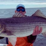
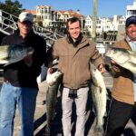
Primary Target: Striped Bass
The striped bass migration is the main event in South Jersey right now. Massive schools of Atlantic menhaden (bunker) are holding just off the beaches, and the trophy-sized bass are right on their tails. Whether you are working the suds in the surf, balancing on the inlet jetties, or drifting the back bays, stripers are actively feeding. The spring run is proving to be incredibly strong, providing excellent action for anglers willing to put in the time during low-light hours.
Secondary Target: Summer Flounder (Fluke)
With the season freshly opened, summer flounder fishing is heating up rapidly in the shallow backwaters. These flatfish have spent the early spring warming up and feeding aggressively on the muddy bottoms of the bays. As the season progresses, they are beginning their transitional push toward the ocean inlets, making them highly accessible to small boat and kayak anglers.
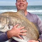
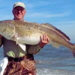
Sleeper Pick: Bluefish and Black Drum
While the local crowds are hyper-focused on stripers and fluke, do not overlook the slammer bluefish patrolling the inshore waters. These "gators" are aggressively hitting trolled lures and surface plugs, providing chaotic, reel-screaming action. Additionally, black drum are making a very solid showing in the back bays, offering a heavy-pulling, bottom-fishing alternative for those soaking baits in the deeper holes.
Baitfish Report
The forage base is incredibly rich and diverse right now. Match your lure presentations and bait choices to these specific baitfish profiles for the highest success rates on the water:
Adult Atlantic Menhaden (Bunker): Holding in large pods along the beachfronts, drawing in the larger migratory bass.
Peanut Bunker: Active in the estuaries and back bays, heavily targeted by summer flounder and schoolie stripers.
Finger Mullet and Spot: Moving through the inlet bottlenecks, providing excellent forage for bluefish and ambush predators.
TACTICAL STRATEGY
Where to Deploy
For shore-based anglers, the Absecon Inlet jetty system is the undisputed hotspot. Specifically, focus your efforts on the seven 90-degree jetties that extend into the deep inlet waters near Clam Creek and Gardiner's Basin. These structures sit in 30-plus feet of water and create perfect ambush points for predators waiting for bait to be swept by. If you are targeting summer flounder from a vessel, set up your drifts in Absecon Bay, focusing on the 8 to 12-foot channel edges where the water warms up quickest under the spring sun, drawing bait out of the shallows.
Lure Selection
For targeting aggressive striped bass, throw 6-inch to 7-inch floating swimming plugs like the Daiwa Salt Pro Minnow, or utilize large topwater pencil poppers when you observe surface feeding activity. For summer flounder, the gold standard remains a 1/2 oz to 3/4 oz bucktail jig tipped with a 5-inch Berkley Gulp! Swimming Mullet or Gulp! Grub. The key is to keep the jig bouncing rhythmically along the bottom to simulate a fleeing baitfish.
Color Patterns
Water clarity can fluctuate wildly with the spring tides and wind directions. In clean, green water, stick to Bone, Pearl White, or Wonderbread patterns for your striper plugs. For the flounder jigs, Chartreuse and Nuclear Chicken (Pink/Green) are outproducing everything else on the deck, especially when the back bay waters get a little stained from the tidal pull.
Bait and Rigging
If you prefer the patience of soaking bait, fresh salted clams or fresh bunker chunks are the absolute ticket for striped bass and black drum. Rig these on a fish-finder slide with a short 20-pound fluorocarbon leader to prevent line shyness.
Pro Tip: Non-offset circle hooks are legally required when targeting striped bass with natural bait. This ensures the fish is hooked in the corner of the mouth, allowing for a safe and healthy catch-and-release, which is critical given the strict slot limits.
Timing the Bite
The outgoing tide is the golden window for the Absecon Inlet. As the warmer water and baitfish get flushed out of the back bays and into the ocean, predatory fish stack up along the jetty breaks and current seams to ambush their prey. Focus your efforts on the last two hours of the ebb tide and the first hour of the flood tide, particularly if this tidal phase aligns with the dawn or dusk periods.
Pro Tip: Flounder are heavily concentrated in the backwater bottlenecks right now. Instead of aimlessly drifting the vast open flats, pinpoint the narrow thoroughfares where the tidal current accelerates. These natural funnels act as a conveyor belt of bait, and the fluke will stack up right at the drop-offs waiting for an easy meal.
REGULATIONS SNAPSHOT
Note: Always verify current regulations with the New Jersey Division of Fish and Wildlife before harvesting fish, as mid-season adjustments can occur. Fish must be measured from the tip of the snout to the tip of the tail.
Pro Tip: A free New Jersey Saltwater Recreational Registry Program certificate is required for all anglers fishing in tidal waters. Make sure you register online and carry your proof of registration before making your first cast.
REGIONAL ALTERNATIVE
If the Absecon Inlet is too crowded with other anglers, or if a heavy ocean swell makes jetty fishing unsafe, pack up your gear and take the short drive north to Brigantine Beach. This beautiful barrier island offers miles of pristine surf fishing opportunities away from the hustle and bustle of the city.
You will need a specific 4-wheel-drive permit to drive your vehicle directly onto the beach, but walk-on access points are plentiful and easily accessible. The deep trough running parallel to the shoreline here is an excellent secondary location for intercepting migrating striped bass and cruising bluefish. Swap out your shorter jetty gear for a 10 to 11-foot surf rod capable of throwing heavy weights. Rig up a standard high-low surf rig with fresh clam or bunker, and cast just past the breaking waves. Look for cuts in the sandbar where the water rushes back out to sea; these rip currents are natural highways for predatory fish looking to ambush disoriented baitfish.
Tight lines!
Editor's Choice: Must-Have Gear
FISHINGSIR Next-Gen Waterproof Chest Waders
★★★★★4.4 (7,370+ reviews)
2-Ply Tech: Upgraded nylon with 2.5x higher density than standard fabrics.
100% Waterproof: Lab-approved intrusion resistance with taped visible seams.
Ultra-Lightweight: Designed for all-day comfort while hunting or fishing.
As an Amazon Associate I earn from qualifying purchases. #ad
Loading forecast...
Live Fishing Conditions: Tides, Weather & Waves
Get real‑time tides, marine weather, swell and solunar activity for each spot so you know exactly when conditions line up for your best chance at a bite.
🎣
Atlantic City
Loading coordinates...
🌤️
WEATHER CONDITIONS
--°F
--°C
Loading...
🌡️
Feels Like--°F--°C
💧
Humidity--%
💨
Wind-- mph-- km/h
🧭
Direction--
📊
Pressure-- inHg-- hPa
☀️
UV Index--
🌊
MARINE CONDITIONS
🌊Wave Height
-- ft
-- m
Loading...
🧭Wave Direction
--°
Loading...
⏱️Wave Period
-- s
Loading...
📈Tide Status
-- ft
-- m
Loading...
🌙
LUNAR & SOLUNAR
🌕
Loading...
Illumination: --%
Major Period--:-- - --:----:-- - --:--
Minor Period--:-- - --:----:-- - --:--
🌅Sunrise--:--
🌇Sunset--:--
📅
24-HOUR FORECAST
Loading fishing conditions...
Fishing Spots Map
🎣
Book a Fishing Charter near Atlantic City Fishing Report Today 🎣
Local guides & charters. Verified captains, instant booking, best price guaranteed.
There was an error loading the map. Please try refreshing the page.
Info
Local Access & Facilities
Atlantic City Pre-Trip Checklist
Local Access & Facilities
Atlantic City offers a fishing environment that stands as a stark, fascinating contradiction. While the skyline is defined by high-rise casinos and the bustle of the boardwalk, the surrounding waters comprise some of the most pristine and productive estuarine systems in the Northeast. Seasoned anglers know that just beyond the urban corridor lies a complex network of back bays, tidal wetlands, and the open Atlantic, offering diverse targets ranging from doormat fluke to migrating stripers.
The fishery here is defined by its proximity to massive protected zones, specifically the Edwin B. Forsythe National Wildlife Refuge and the Great Egg Harbor National Wild and Scenic River. Unlike typical urban harbors, the water quality and habitat here are supported by over 48,000 acres of protected coastal wetlands. This creates a unique dynamic where you can launch within sight of the city lights but fish in shallow coves and salt marshes that feel completely removed from civilization. The bottom topography varies wildly, from the deep channels of the Absecon Inlet to the treacherous, shifting shoals of the Great Bay.
For the serious captain, this area requires a shift in mindset. You aren't just navigating a harbor; you are threading the needle between a "densely populated urban corridor" and the Jacques Cousteau National Estuarine Research Reserve, regarded as one of the least disturbed estuaries in the region. Success here depends on understanding the interplay between the heavy boat traffic of the main channels and the quiet, tide-dependent flats where the game fish hunt.
Access & Getting There
Reaching the prime fishing grounds around Atlantic City generally involves navigating the Garden State Parkway or the Atlantic City Expressway. For anglers towing trailers, the approach requires strategic timing. The summer shore traffic can be brutal, particularly on weekends. Most access to the northern wetlands and the Mullica River/Great Bay area is via Garden State Parkway Exit 58 (Route 539) or Exit 48 (Route 9). If you are targeting the southern backwaters or the Great Egg Harbor River, you will likely utilize routes near Somers Point or Mays Landing off Route 50.
5th Street Boat Ramp serves as a primary launch point for getting into the immediate area, located approximately 5 miles from the city center. However, captains should be aware that the launch infrastructure varies significantly across the region. While the main ramps are serviceable, accessing the quieter zones often means utilizing smaller, tide-dependent points. The Great Egg Harbor River access, located about 11 miles out near Estell Manor, offers a gateway to the wilder, scenic sections of the river system, but requires a drive inland.
💡 Captain's Tip: Watch the Gate Clock
If you are fishing the Edwin B. Forsythe National Wildlife Refuge areas via land or launching small craft from within the refuge boundaries, strict hours apply. The gates on Great Creek Road open at sunrise and close promptly at sunset. Do not get locked in after a late bite.
Parking logistics vary heavily by your specific launch site. In Atlantic City proper, Park Place Parking on Dr. Martin Luther King Blvd offers 24-hour access, which is crucial for surf casters or those hitting the dawn patrol hard. For those trailering further inland or north, spots like the Absecon Station Parking Lot provide alternatives, though they are further from the water. When accessing the remote Holgate Wilderness Area during the open season, a beach buggy permit is mandatory, and vehicle access is strictly regulated to protect the barrier island ecosystem.
Weather contingencies are critical in this region. The shallow bays behind the barrier islands, particularly around Great Bay and Little Egg Harbor, can whip into a dangerous chop quickly when the wind opposes the tide. If the Atlantic is blown out, the protected waters of the Mullica River offer a viable "Plan B," but navigational caution is required due to shifting sandbars and mudflats.
Facilities & Amenities
The local infrastructure supports a serious fishing culture, but amenities are spread out across the barrier islands and the mainland. You won't find a single centralized "fishing center," but rather a network of specialized shops serving specific zones. For anglers in Atlantic City or Ventnor, Ship Shop Bait & Tackle is the closest reliable outfitter, located just 2.5 miles away. They are well-positioned for those fishing the Absecon Inlet or the immediate surf.
If your expedition takes you south towards the Great Egg Harbor Inlet, Tight Lines Bait and Tackle in Somers Point is the strategic stop. They open at 6:00 AM most days, catering to the early risers heading out to the drag. Conversely, if you are fishing the northern pristine waters near the Jacques Cousteau Reserve, Bogin's Bait and Tackle in Tuckerton or Scott's Bait & Tackle in Little Egg Harbor are your best bets for fresh bait and local intelligence on the Mullica River bite.
💡 Captain's Tip: Fuel Logistics
While bait is plentiful, on-water fuel can be scarce in the backwater tributaries. If you are running the Great Egg Harbor River or the upper Mullica, top off your tanks on the highway. There are long stretches of marshland with absolutely no commercial services.
The charter fleet here is diverse, reflecting the varied fishery. Get Hooked Fishing Charters operates out of Brigantine, perfect for quick access to the inlet and nearshore wrecks. For those looking to explore the southern bays, Shore Thing Charters and Moover Fishing Adventures in Ocean City have solid reputations. The accommodation scene is split between high-end casino hotels and mainland campgrounds. Trailer boaters often prefer spots like Ocean Isle Campground or Belhaven Lake RV Resort, which offer more space for rigs than the cramped city garages.
Facility Name
Type
Distance
Special Notes
Ship Shop Bait & Tackle
Bait & Tackle
2.5 miles
Closest to AC; opens 7 AM.
Tight Lines Bait and Tackle
Bait & Tackle
9.1 miles
Somers Point hub; opens 6 AM.
Get Hooked Fishing Charters
Charter
4.9 miles
Brigantine based; near inlet.
Park Place Parking
Parking
0.6 miles
Open 24 Hours; Rating: 5/5.
Marriott's Fairway Villas
Lodging
6.5 miles
Galloway; upscale option.
Permits, Regulations & Fees
Navigating the regulations in this region requires attention to detail because you are often crossing between state waters and federal protected lands. The Edwin B. Forsythe National Wildlife Refuge and the Jacques Cousteau National Estuarine Research Reserve have specific mandates designed to protect migratory birds and the estuarine environment. While general fishing is managed by the State Fishing Agency, access to specific spots within the refuges may be restricted seasonally.
For example, the Holgate Wilderness Area is closed to all public access (including pedestrians and vehicles) during the nesting season, typically from April 1 through August 31. It reopens on September 1, at which point beach buggy permits from Long Beach Township are required for vehicle access. This is a strict conservation measure; respect for these boundaries is essential to maintaining angler access to these pristine strips of coast.
In the Great Egg Harbor National Wild and Scenic River, local jurisdictions administer the lands, but the National Park Service oversees the designation. This means while you are fishing state waters, you are in a zone of high ecological sensitivity. "Kapu" or respect for the land is not just a Hawaiian concept; here, it translates to respecting the "True People" (Lenni Lenape) heritage of the land and the fragile salt marsh ecosystem. Tread lightly, especially in the shallow back bays where prop scars can damage the habitat for decades.
Events & Seasonal Information
The fishing calendar in Atlantic City is dictated by migration patterns. The area is a critical stop on the Atlantic Flyway, and the movement of birds often mirrors the movement of baitfish. The spring and fall runs are the high points of the year. During the fall, as water temperatures drop, stripers move out of the back bays and down the beach, creating world-class surf fishing opportunities along the barrier islands.
Summer brings the tourist crowds and heavy boat traffic, particularly around the inlets and the Intracoastal Waterway. The "summer calm" can be deceptive; afternoon sea breezes often kick up a significant chop in the open bays by 10:00 AM. Experienced locals know to fish the "dawn patrol" window to avoid both the wind and the jet skis. The Jacques Cousteau Reserve area is particularly sensitive to seasonal changes, serving as a nursery for many species. Winter fishing is quieter, focused on resident species, but access to remote areas like Holgate becomes a prime draw for hardy surf casters after September 1st.
💡 Captain's Tip: Tides Matter More Here
In the shallow estuaries of the Great Bay and behind Brigantine, the tide swing is significant. Low tide can turn a navigable shortcut into a mudflat instantly. Always consult a local tide chart specifically for the back bays, not just the ocean inlet, as the lag time can be over an hour.
Contact Information & Resources
For the most current information on access and conditions, direct contact with the managing agencies is recommended. The Edwin B. Forsythe National Wildlife Refuge headquarters can be reached at 609-652-1665 or via email at forsythe@fws.gov. For questions regarding the Jacques Cousteau National Estuarine Research Reserve, contact their office at 609-812-0649 x 206. Matters concerning the Great Egg Harbor River are often best directed to the local county contacts or the NPS regional office.
Safety is paramount. This is a mixed-use waterway with commercial traffic, recreational fleets, and shallow hazards. There is no single harbor master for the entire region, so self-reliance is key. Ensure your VHF radio is functional and you have a solid float plan before heading into the vast marshlands where cell service can be spotty.
For precise locations, real-time wind conditions, and detailed maps of the boat ramps and tackle shops mentioned above, consult the live dashboard and interactive widgets below.
🎣
Atlantic City
Atlantic City • New Jersey • 39.3609, -74.4388
🅿️
Parking
5
Park Place Parking
⭐ 5.00.6 mi
📍148 S Dr Martin Luther King Blvd, Atlantic City, NJ 08401, USA
Our spot reports combine data-driven forecasts with curated local information. The forecast is generated by our proprietary Fishing Score algorithm (0–100%), which analyzes real-time data from Open-Meteo API, validated against NOAA CO-OPS tide gauges and USGS water-monitoring stations. The model weights tide dynamics (35%), wave energy (25%), wind patterns (20%) and time of day (20%)—factors shown to influence fish feeding behavior through marine-biology research and decades of charter log data.
Access, facilities and services information for each fishing spot is sourced from official datasets such as Recreation.gov (RIDB), state park & wildlife agencies, and geospatial providers like Google Maps. These sections undergo scheduled re-validation every 3–6 months to ensure that boat ramps, park access, contact details and local services remain accurate.
Narrative sections (catches, seasonal behavior, local tips) are synthesized from these data sources and refined following the Fishing Reports Today editorial guidelines, combining bibliographic research from ichthyology and oceanography with expert angler experience. Our team reviews reports on a regular basis, while the forecast model itself updates every 6 hours for real-time accuracy.
⚠️ Important: Always verify current local regulations, access restrictions and weather conditions before fishing. These reports are intended as a planning aid, not a guarantee of catches or safety. When in doubt, contact local authorities or park managers listed on the page.
To provide the best experiences, we use technologies like cookies to store and/or access device information. Consenting to these technologies will allow us to process data such as browsing behavior or unique IDs on this site. Not consenting or withdrawing consent, may adversely affect certain features and functions.
Functional Always active
The technical storage or access is strictly necessary for the legitimate purpose of enabling the use of a specific service explicitly requested by the subscriber or user, or for the sole purpose of carrying out the transmission of a communication over an electronic communications network.
Preferences
The technical storage or access is necessary for the legitimate purpose of storing preferences that are not requested by the subscriber or user.
Statistics
The technical storage or access that is used exclusively for statistical purposes.The technical storage or access that is used exclusively for anonymous statistical purposes. Without a subpoena, voluntary compliance on the part of your Internet Service Provider, or additional records from a third party, information stored or retrieved for this purpose alone cannot usually be used to identify you.
Marketing & Affiliates
The technical storage or access is required to create user profiles to send advertising, or to track the user on a website or across several websites for similar marketing purposes, including affiliate tracking for products recommended in our reports.


Leave a Reply