Little Egg Harbor Fishing Report: Early Summer Estuary Action
The transition into the early summer pattern is an exceptional time to be on the water in the New Jersey back bays. Water temperatures have successfully pushed past the critical 60-degree mark, settling comfortably into the mid-60s across the shallow flats and tidal creeks. This thermal shift has triggered a massive influx of biomass into the Little Egg Harbor and Great Bay estuary systems. The sluggish, cold-water lethargy of early spring is officially behind us. Aggressive feeding windows are widening, the water clarity has improved, and the sheer variety of species actively feeding makes this one of the most productive stretches of the season for local anglers.
1. GO/NO-GO STATUS
Verdict: GO
Current conditions are highly favorable for both center console boaters and kayak anglers. The bay waters have warmed significantly, eliminating any lingering cold-water safety threats that plague the early season. However, anglers must remain vigilant regarding the daily meteorological shifts typical of the Jersey Shore this time of year. As the landmass heats up throughout the morning, a standard afternoon sea breeze will develop. South and southwest winds frequently kick up to 15 to 20 knots after lunch, which can create a tight, uncomfortable, and potentially hazardous chop in the open waters of the bay.
🎣Nautrek
Private Beta
J
M
R
100+ anglers on the waitlist
The fishing network where your reputation matters.
Find trusted captains, join real trips with cost splitting, and build your Angler Rank. Your spots stay private — you decide who sees your intel.
Furthermore, when a stiff southerly wind opposes a hard outgoing tide, the bay will stand up, making boat control incredibly difficult and ruining the natural presentation of your baits. Plan your longest runs and open-water drifts for the dawn and early morning hours. As the wind machine turns on, retreat to the leeward shorelines, the winding creeks behind Long Beach Island, or the protected sod banks.
Pro Tip: Always deploy a drift sock (sea anchor) when the wind outpaces the current. A proper drift speed for flatfish is between 0.8 and 1.2 knots. If the wind is pushing you at 2 knots or faster, your baits will spin unnaturally off the bottom, and your strike rate will plummet.
2. SPECIES INTEL
Based on recent biological sampling and verified catches across the Barnegat Bay to Little Egg Harbor corridor, the food web is firing on all cylinders.
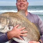
Primary Target:Summer Flounder (Fluke). The flatfish have fully migrated out of their deep wintering grounds and are actively staging along channel edges, ICW drop-offs, and shallow mudflats to intercept bait pushed by the tide.
Sleeper Pick:Weakfish (Trout). Often viewed as a ghost of the past by modern saltwater anglers, beautiful weakfish are showing up with surprising consistency. They are holding in the deeper cuts and sod bank undercuts, feeding heavily during low-light hours.
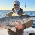
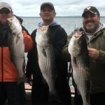
Secondary Target:Striped Bass & Bluefish. While the massive migratory cows have mostly pushed north, a healthy population of resident schoolie stripers (20 to 30 inches) remains in the bay. Roving packs of 2 to 4-pound bluefish are also terrorizing bait schools near the surface.
Baitfish Report: The estuary is absolutely loaded with forage. We are seeing massive schools of spearing (silversides), early pushes of peanut bunker (juvenile Atlantic Menhaden), and grass shrimp. Additionally, blue crabs are beginning their shedding cycles, making soft shell and shedder crabs a high-protein target for opportunistic predators.
3. TACTICAL STRATEGY
To consistently put fish in the boat right now, you need to abandon dead-sticking and start covering ground strategically. The fish are actively hunting, and your presentations must match the cadence of fleeing prey.
Where to Find Them
Focus your efforts on the 6 to 10-foot channel edges along the Intracoastal Waterway (ICW). Specifically, work the stretches between the BB and 42 markers, and the tidal rips near the Great Bay Boulevard bridges. For early morning stripers, target the sod banks at Graveling Point and Osborn Island, where the Mullica River outflow meets the bay. If you are targeting weakfish, look for the 12 to 15-foot holes behind Holgate and the sedge islands, dropping your baits right into the deepest part of the depression.
Lure Selection & Cadence
Fluke Lures: Drop a 3/8oz to 1/2oz bucktail jig painted in white or chartreuse, tipped with a 4-inch Gulp! Swimming Mullet in Nuclear Chicken or Pink Shine. Tie a dropper loop 12 to 16 inches above the jig and add a 3/8oz plain lead jighead with a secondary Gulp! bait. Do not just drag the rig. Use short, sharp snaps of the rod tip to make the bucktail dart off the bottom, simulating a fleeing shrimp or wounded spearing.
Striped Bass & Bluefish: Troll 5 to 6-inch floating Yo-Zuri Crystal Minnows or Daiwa SP Minnows in natural patterns (dark back with a white belly) at 3 to 4 knots along the channel edges.
Bait Recommendations
If you prefer soaking natural bait for fluke, a traditional high-low rig drifted with live killies (mummichogs) or a long strip of squid paired with a fresh spearing is deadly. For weakfish, float small, silver-dollar-sized pieces of shedder crab or live bloodworms just inches off the bottom near deep sod bank undercuts.
Timing the Bite
Tide is the single most important variable in this estuary. The absolute best bite is occurring on the outgoing tide. The summer sun bakes the shallow grass flats throughout the day, and the outgoing current flushes this warmer, bait-rich water directly into the deeper staging channels. Set up your drifts to intersect these 4-to-8-foot drop-offs just as the tide starts pulling hard.
Pro Tip: Keep a medium-action spinning rod rigged with a topwater popper on the casting deck at all times. Schools of aggressive bluefish are randomly pushing bait to the surface throughout the day. A fast, splashy retrieve with a popper will get instantly crushed, but you only have a few seconds to capitalize before the school dives.
4. REGULATIONS SNAPSHOT
Before hitting the water, ensure you are registered with the free NJ Saltwater Recreational Registry. Enforcement is strict during the summer months. Here are the current 2026 limits for key local species:
Species
Minimum Size
Bag Limit
Season & Gear Notes
Summer Flounder (Fluke)
18 inches
3 per person
Open season. Measure from tip of snout to pinched tail.
Striped Bass
28" to 31" Slot
1 per person
Strict slot limit. Must use non-offset circle hooks with natural bait.
Bluefish
No minimum
3 per person
Shore/Private vessel limit. (Limit is 5 for for-hire/charter vessels).
Season is currently closed. Must be released immediately until August 1.
5. REGIONAL ALTERNATIVE
If the primary open waters of Little Egg Harbor are blown out by heavy southern winds, trailer your vessel slightly north to the protected waters of Barnegat Light's bayside or the High Bar Harbor Dike. You can launch easily at the Robert Nissen Park (Ship Bottom Boat Ramp). This area offers excellent wind protection and fantastic light-tackle fishing.
You can effectively drift the 4 to 8-foot flats for fluke without fighting the whitecaps, or cast soft plastic paddletails against the bulkheads and sod banks for resident striped bass. The streetlights in this specific area also draw in massive clouds of bait at night, making it a prime location for after-dark striper missions when the boat traffic has completely died down. Work the shadow lines of the bridges and docks with slow-retrieved swimbaits for the best results.
Tight lines!
Editor's Choice: Must-Have Gear
FISHINGSIR Next-Gen Waterproof Chest Waders
★★★★★4.4 (7,370+ reviews)
2-Ply Tech: Upgraded nylon with 2.5x higher density than standard fabrics.
100% Waterproof: Lab-approved intrusion resistance with taped visible seams.
Ultra-Lightweight: Designed for all-day comfort while hunting or fishing.
As an Amazon Associate I earn from qualifying purchases. #ad
Loading forecast...
Live Fishing Conditions: Tides, Weather & Waves
Get real‑time tides, marine weather, swell and solunar activity for each spot so you know exactly when conditions line up for your best chance at a bite.
🎣
Little Egg Harbor, NJ
Loading coordinates...
🌤️
WEATHER CONDITIONS
--°F
--°C
Loading...
🌡️
Feels Like--°F--°C
💧
Humidity--%
💨
Wind-- mph-- km/h
🧭
Direction--
📊
Pressure-- inHg-- hPa
☀️
UV Index--
🌊
MARINE CONDITIONS
🌊Wave Height
-- ft
-- m
Loading...
🧭Wave Direction
--°
Loading...
⏱️Wave Period
-- s
Loading...
📈Tide Status
-- ft
-- m
Loading...
🌙
LUNAR & SOLUNAR
🌕
Loading...
Illumination: --%
Major Period--:-- - --:----:-- - --:--
Minor Period--:-- - --:----:-- - --:--
🌅Sunrise--:--
🌇Sunset--:--
📅
24-HOUR FORECAST
Loading fishing conditions...
Fishing Spots Map
🎣
Book a Fishing Charter near Little Egg Harbor, NJ Fishing Report Today 🎣
Local guides & charters. Verified captains, instant booking, best price guaranteed.
There was an error loading the map. Please try refreshing the page.
Info
Local Access & Facilities
Little Egg Harbor represents one of the most pristine and ecologically significant fisheries on the Eastern Seaboard. Situated at the convergence of the Mullica River and Great Bay, this area is defined by its status as part of the Jacques Cousteau National Estuarine Research Reserve. Unlike the manicured marinas found further north, this fishery is a rugged patchwork of salt marshes, shallow coves, and pine barrens. The bottom topography here is dominated by shifting sandbars and nutrient-rich mudflats that fuel a massive food web.
The atmosphere is deceptively quiet, contrasting sharply with the neon glow of Atlantic City located just 17 miles to the south. Seasoned anglers know that the lack of development along the shoreline—less than 1% of the Reserve is developed—translates to exceptional water quality and undisturbed habitat. This is not a location for casual cruising; it is a tactical fishery where understanding tidal movements through the sedge banks is paramount.
The primary draw for experts here involves the seasonal migrations that push through the Atlantic Flyway. The same nutrient density that supports thousands of migratory birds attracts game fish into the shallow thoroughfares. Whether you are poling a skiff through the backwaters or setting up for a drift in the main channels of Great Bay, the ecosystem here supports a diverse array of target species that thrive in the brackish mix of fresh river water and Atlantic salt.
Access & Getting There
Reaching the prime waters of Little Egg Harbor usually involves navigating the Garden State Parkway. For direct access to the Jacques Cousteau Coastal Education Center and the northern reaches of the harbor, seasoned drivers utilize Exit 58 (Route 539) toward Tuckerton. Traffic on the Parkway can be heavy during summer weekends, so planning your transit to avoid mid-morning congestion is essential. Once off the highway, the route transforms into local roads like Great Bay Blvd, which leads directly into the heart of the marshlands.
Launching a vessel here requires attention to the tides. While there are several access points, the ramps can become slick and shallow during dead low tide. The Great Egg Harbor River access, located at Estell Manor Park roughly 24 miles from the harbor center, offers a reliable launch for those targeting the river system specifically. For those focusing on the bay, local street-end launches and smaller ramps near Tuckerton are often preferred, though parking capacity is strictly limited. It is common for trailer parking to reach capacity before 6:00 AM during the peak fall run.
💡 Captain's Tip: Watch the Wind
The shallow nature of Great Bay means that wind creates chop instantly. If the forecast calls for winds exceeding 15 knots, particularly against the tide, the open bay becomes treacherous. Stick to the leeward side of the sod banks or the protected waters of the Mullica River.
Weather contingencies are a critical part of the logistics plan in this region. The Edwin B. Forsythe National Wildlife Refuge offers miles of shoreline access, but it is highly exposed to the elements. During strong northeasters, the "Wildlife Drive" and exposed points like Graveling Point can become unfishable or even inaccessible due to flooding. Always have a backup plan that involves protected waters further inland along the river systems if the bay is blown out.
Parking requires a defensive strategy. At popular spots like Scott's Landing or the end of Radio Road at Graveling Point, space is at a premium. Ensure your vehicle is parked well clear of the high tide line, as tidal flooding is a frequent occurrence on these low-lying access roads. Security is generally good, but leaving valuables in plain sight at remote marsh access points is never advisable.
Little Egg Harbor, NJ Pre-Trip Checklist
Facilities & Amenities
The infrastructure around Little Egg Harbor is geared towards the serious sportsman rather than the tourist. Bogin's Bait and Tackle, located just 1.7 miles from the center of the action in Tuckerton, is the primary logistical hub. This shop opens at 6:00 AM on weekdays and 5:00 AM on weekends, perfectly timing the needs of the dawn patrol crowd. For those approaching from the north, Creekside Outfitters in Waretown offers an alternative stop for fresh bait and terminal tackle.
The local charter fleet is robust, with a focus on light tackle inshore fishing and heavy offshore runs. Operators like LBI Fishing Charters and Capt. Jack's operate out of the nearby Beach Haven area, roughly 6 miles away. These captains specialize in navigating the shifting shoals of the inlet and the bay. It is worth noting that while fuel is available at major marinas, many of the smaller, rustic launches in the refuge areas have absolutely no amenities—no fuel, no ice, and no water. You must be fully self-sufficient before leaving the pavement.
💡 Captain's Tip: Fuel Management
There are no fuel docks within the National Wildlife Refuge or the primitive launch sites. Top off your tanks at highway stations before turning onto the access roads like Great Bay Blvd.
Lodging options vary from rustic to resort-style. For the hardcore angler, Pilgrim Lake Campgrounds is located only 5 miles away in New Gretna, allowing for maximum time on the water. For those requiring more comfort or traveling with family, the Marriott's Fairway Villas in Galloway provide high-end amenities about 11 miles from the fishing grounds. Belhaven Lake RV Resort is another solid option for those towing campers.
Facility Name
Type
Distance
Key Notes
Bogin's Bait and Tackle
Bait Shop
1.7 miles
Opens 5 AM weekends; located in Tuckerton.
LBI Fishing Charters
Charter
6.7 miles
Based in Beach Haven; 24-hour availability listed.
Pilgrim Lake Campgrounds
Lodging
5.0 miles
Closest camping option; open seasonally.
Park Place Parking
Parking
16.4 miles
Located in Atlantic City; open 24 hours.
Permits, Regulations & Fees
Fishing in Little Egg Harbor places you within a complex overlap of state and federal jurisdictions. The area is managed primarily by the State Fishing Agency, but the specific rules of the Jacques Cousteau National Estuarine Research Reserve and the Edwin B. Forsythe National Wildlife Refuge must be respected. These regulations exist to protect the fragile salt marsh ecosystem that serves as a nursery for the very game fish anglers pursue.
Access to the Holgate Wilderness Area is strictly regulated. This zone is open to the public only from September 1 through March 31 to protect nesting shorebirds. During the open season, surf fishing vehicles are permitted, but a specific beach buggy permit must be obtained from Long Beach Township. Failure to secure this permit or driving in closed nesting areas can result in significant federal fines.
Cultural respect is also paramount. The refuge lies on the indigenous homelands of the Lenni Lenape people, who were the first to harvest seafood from these waters. Anglers are expected to practice "leave no trace" ethics. Additionally, private property lines along the creeks can be ambiguous; always look for purple paint or signage indicating private land, and stick to designated public access points like Scott's Landing and Graveling Point.
Events & Seasonal Information
The rhythm of this fishery is dictated by the seasons. The spring and fall migrations are the high points, aligning with the movements of striped bass and bluefish entering the estuary. The summer months bring a slower pace, with warm water species dominating the shallow flats. The Holgate Wilderness Area closure in spring and summer (April through August) is a major calendar event that dictates where surf anglers can operate.
Timing your day is critical. The gates to the Edwin B. Forsythe National Wildlife Refuge at Great Creek Road open strictly at sunrise and close at sunset. Getting locked in is a real possibility for anglers pushing the evening bite too late. In terms of daily timing, the trade winds often pick up by late morning. Experienced skippers aim to be on their spot at first light to capitalize on the calm surface conditions before the bay chop builds.
💡 Captain's Tip: Gate Awareness
The main gate at the Wildlife Refuge is automated or strictly managed. If you are parked inside the gate at sunset, you may be locked in until the following morning. Always check the posted closing times at the entrance.
Contact Information & Resources
For the most current information on access and conditions, direct contact with the managing agencies is recommended. The Jacques Cousteau National Estuarine Research Reserve can be reached at 609-812-0649. For inquiries regarding the Edwin B. Forsythe National Wildlife Refuge, including trail closures and pass information, call 609-652-1665 or email forsythe@fws.gov.
Safety in this remote marsh environment is the responsibility of the angler. Cell phone reception can be spotty in the low-lying areas of the reserve. Always file a float plan with a reliable contact before heading out into the bay or the river systems. For precise locations and real-time conditions, consult the live dashboard and maps below.
🎣
Little Egg Harbor, NJ
Little Egg Harbor Township • New Jersey • 39.5887, -74.3655
🅿️
Parking
5
Park Place Parking
⭐ 5.016.4 mi
📍148 S Dr Martin Luther King Blvd, Atlantic City, NJ 08401, USA
Our spot reports combine data-driven forecasts with curated local information. The forecast is generated by our proprietary Fishing Score algorithm (0–100%), which analyzes real-time data from Open-Meteo API, validated against NOAA CO-OPS tide gauges and USGS water-monitoring stations. The model weights tide dynamics (35%), wave energy (25%), wind patterns (20%) and time of day (20%)—factors shown to influence fish feeding behavior through marine-biology research and decades of charter log data.
Access, facilities and services information for each fishing spot is sourced from official datasets such as Recreation.gov (RIDB), state park & wildlife agencies, and geospatial providers like Google Maps. These sections undergo scheduled re-validation every 3–6 months to ensure that boat ramps, park access, contact details and local services remain accurate.
Narrative sections (catches, seasonal behavior, local tips) are synthesized from these data sources and refined following the Fishing Reports Today editorial guidelines, combining bibliographic research from ichthyology and oceanography with expert angler experience. Our team reviews reports on a regular basis, while the forecast model itself updates every 6 hours for real-time accuracy.
⚠️ Important: Always verify current local regulations, access restrictions and weather conditions before fishing. These reports are intended as a planning aid, not a guarantee of catches or safety. When in doubt, contact local authorities or park managers listed on the page.
To provide the best experiences, we use technologies like cookies to store and/or access device information. Consenting to these technologies will allow us to process data such as browsing behavior or unique IDs on this site. Not consenting or withdrawing consent, may adversely affect certain features and functions.
Functional Always active
The technical storage or access is strictly necessary for the legitimate purpose of enabling the use of a specific service explicitly requested by the subscriber or user, or for the sole purpose of carrying out the transmission of a communication over an electronic communications network.
Preferences
The technical storage or access is necessary for the legitimate purpose of storing preferences that are not requested by the subscriber or user.
Statistics
The technical storage or access that is used exclusively for statistical purposes.The technical storage or access that is used exclusively for anonymous statistical purposes. Without a subpoena, voluntary compliance on the part of your Internet Service Provider, or additional records from a third party, information stored or retrieved for this purpose alone cannot usually be used to identify you.
Marketing & Affiliates
The technical storage or access is required to create user profiles to send advertising, or to track the user on a website or across several websites for similar marketing purposes, including affiliate tracking for products recommended in our reports.


Leave a Reply