


Barnegat Township: The Intersection of Pine Barrens and Saltwater
Situated at the convergence of the vast New Jersey Pinelands and the Atlantic Ocean, Barnegat Township offers a fishery defined by its ecological diversity and historical significance. This is not merely a recreational harbor; it is the gateway to one of the least disturbed estuaries in the densely populated urban corridor of the Northeastern United States. The waters here are influenced heavily by the Mullica River-Great Bay ecosystem, creating a nutrient-rich environment that sustains a massive food web. Experienced anglers know that the health of this estuary, protected largely by the Jacques Cousteau National Estuarine Research Reserve, translates directly to the quality of the game fish populations.
The atmosphere in Barnegat is a distinct blend of rugged coastal wilderness and established maritime tradition. Unlike the manicured, concrete-lined harbors found further north, much of the access here revolves around salt marshes, tidal wetlands, and the barrier islands. The presence of the Edwin B. Forsythe National Wildlife Refuge means that miles of shoreline remain undeveloped, offering a raw, quiet fishing experience that feels worlds away from the bustle of the Jersey Shore boardwalks. Whether you are poling a skiff through the shallows of the sedge banks or launching for a run to the offshore grounds, the backdrop is often dominated by swaying cordgrass and the distinct silhouette of pitch pines.
For the serious captain, this location is strategic. It provides dual access to the sheltered waters of Barnegat Bay for light tackle pursuits and the open Atlantic for pelagic runs. The primary targets here shift with the migration patterns, as the area serves as a critical stopover on the Atlantic Flyway. This biological highway ensures a steady stream of baitfish, which in turn attracts the predatory species that seasoned anglers chase. The interplay between the fresh pine-barren runoff and the salty Atlantic tides creates a dynamic salinity gradient, offering unique opportunities for mixed-bag days.
Access & Getting There
Reaching the prime fishing grounds of Barnegat Township generally involves navigating the Garden State Parkway (GSP), which serves as the primary north-south artery. For anglers towing center consoles or larger vessels, the most critical exits are typically Exit 67 for Barnegat proper and Exit 63 for Route 72, which leads east toward Manahawkin and Long Beach Island. Traffic on the GSP can be notoriously heavy during summer weekends, particularly on Friday afternoons and Sunday evenings. Seasoned locals plan their haul-outs to avoid these windows, often opting for late-night or pre-dawn transits to ensure a smooth arrival at the ramp.
Access to the water is distributed across several key points, ranging from improved municipal ramps to more rustic launch sites within the reserves. The Barnegat Branch Trail area offers parking and proximity to the water, but captains should be aware that trailheads often have restrictions on overnight parking. For those heading toward the barrier islands, the Cedar Bonnet Island Trail area, accessible via Route 72, provides a strategic entry point. When accessing the Edwin B. Forsythe National Wildlife Refuge, drivers should navigate via Great Creek Road in Oceanville or the specific trailheads at Mantoloking Road depending on their target quadrant. Note that the refuge gates operate strictly on a sunrise-to-sunset schedule; getting locked in after a late bite is a logistical nightmare to be avoided.
💡 Captain's Tip: Tiding the Gaps
The tidal flow through Barnegat Inlet is legendary for its velocity. When planning your launch or return, especially if your vessel is underpowered, consult the tide tables meticulously. An outgoing tide against an easterly swell creates standing waves in the inlet that can challenge even 30-foot hulls. Plan your ocean transit for slack tide whenever possible.
Weather plays a significant role in accessibility here. The shallow nature of Barnegat Bay means that strong winds, particularly from the northwest, can blow water out of the bay, creating surprisingly low tides that may leave deeper-draft vessels stranded in the channels. Conversely, a stiff northeast wind can stack water against the mainland, flooding low-lying access roads near the sedge banks. Anglers towing trailers should be particularly cautious on the causeways during high wind warnings, as crosswinds on the bridges can be hazardous.
Parking requires a strategic approach, especially during the striped bass runs. While the Huddy Park Lot and the lots at 1 Robbins Parkway in Toms River offer high-capacity parking roughly 13 miles north, local access points closer to Waretown and Barnegat fill up rapidly. The parking situation at the wilder access points, such as those near the Jacques Cousteau Coastal Education Center, is often limited to shell driveways or small gravel lots. Ensure your vehicle is positioned to allow other trailers to maneuver, as space is at a premium and local enforcement is strict regarding blocked thoroughfares.
Barnegat Township, NJ Pre-Trip Checklist
Facilities & Amenities
The infrastructure in Barnegat Township caters to a mix of serious sportfishing and recreational boating. Unlike a centralized marina complex, the amenities here are distributed along the Route 9 corridor. For dawn patrol crews, Creekside Outfitters in Waretown is the primary logistical hub. Located just 2.5 miles from the central fishing zones, this shop is renowned for opening at 6:00 AM, allowing captains to load up on ice, fresh bunker, and terminal tackle before the sun breaks the horizon. Their proximity to the water makes them an essential stop for last-minute intel on where the bite is developing.
For those launching further south or needing specialized gear, Grizz's Forked River Bait and Tackle (6.2 miles away) and Bogin's Bait and Tackle in Tuckerton (12.1 miles away) are pillars of the local fishing community. These shops are not merely retail outlets; they are information exchanges where the daily movements of schools are tracked. Bogin's, in particular, services the southern end of the bay and the Little Egg Harbor area. Anglers targeting heavy game should note that while these shops are well-stocked, specialized offshore rigging services may require a trip further north to Point Pleasant or south to Atlantic City.
| Establishment | Distance | Weekdays | Weekends | Specialization |
|---|---|---|---|---|
| Creekside Outfitters | 2.5 miles | 06:00 AM - 06:30 PM | 06:00 AM - 06:00 PM (Sat) | Local Bait, Ice, Early Access |
| Grizz's Forked River | 6.2 miles | 07:00 AM - 05:00 PM | 07:00 AM - 05:00 PM | General Tackle, Bay Gear |
| Bogin's Bait and Tackle | 12.1 miles | 06:00 AM - 05:00 PM | 05:00 AM - 06:00 PM | Southern Bay Intel |
| LBI Fishing Charters | 13.0 miles | 24 Hours | 24 Hours | Charter Operations |
The charter fleet in this region is robust, with operators like LBI Fishing Charters and Capt. Jack's Fishing Charters running out of the nearby Beach Haven and Long Beach areas. A unique feature of the local charter scene is the availability of 24-hour operations, catering to the night striped bass and bluefish bites that are famous in these estuaries. Visiting anglers looking to learn the intricacies of the sedge banks would do well to book a local guide, as the shifting shoals and channels of the bay can be treacherous for the uninitiated.
💡 Captain's Tip: Fuel Logistics
There are no fuel docks located directly within the wildlife refuges or at the primitive launch sites. Captains must ensure their tanks are topped off at highway stations on Route 9 or Route 72 before hitching up. Running out of gas in the back bays, where tow boat response times can be long due to shallow water, is a mistake you only make once.
Accommodations in the immediate vicinity lean heavily toward the rustic, aligning with the "Pinelands" vibe. Bass River State Forest offers the "South Campground," a favorite for anglers who prefer to sleep near their trailer and launch at first light. For those requiring hookups, Belhaven Lake RV Resort and Pilgrim Lake Campgrounds provide more substantial amenities. High-end hotels are scarce in the immediate fishing zones; most luxury lodging is found on Long Beach Island, which requires crossing the causeway—a factor to consider when calculating travel time to the ramp on busy summer mornings.
Permits, Regulations & Fees
Navigating the regulatory landscape in Barnegat Township requires attention to detail, as the area is a patchwork of state waters, federal refuges, and protected reserves. The New Jersey Department of Environmental Protection (NJ DEP) manages the overarching saltwater registry and fishing regulations. All anglers 16 and older must be registered with the New Jersey Saltwater Recreational Registry Program (NJSRRP). This is a free registration but is mandatory for compliance.
However, the specific overlays of the Edwin B. Forsythe National Wildlife Refuge and the Jacques Cousteau National Estuarine Research Reserve introduce additional layers of governance. The refuge was established to protect tidal wetlands for migratory birds, and as such, human activity is strictly regulated to prevent disturbance. While fishing is a recognized priority public use, it is confined to designated areas. Shore fishing is permitted, but access to certain beaches and marshes may be restricted during nesting seasons. It is critical to respect the "Area Closed" signs, which often protect nesting piping plovers or other sensitive species.
A specific regulation that catches many visitors off guard involves beach access for vehicles. The Holgate Wilderness Area, located at the southern tip of Long Beach Island, is a highly prized surf fishing destination. However, access is seasonal. The area is generally open to walkers and permit-holding surf fishing vehicles from September 1 through March 31. During the spring and summer nesting season, this prime stretch of surf is closed to all human entry. To drive on the beach during the open season, a Beach Buggy Permit from Long Beach Township is required. These permits must be obtained in advance, and vehicles must carry specific safety equipment (tow strap, jack, board, shovel) at all times.
💡 Captain's Tip: The Holgate Closure
The Holgate Wilderness Area closes strictly on April 1st for bird nesting. If you are planning a spring run for stripers in the surf, ensure your trip dates fall before this cutoff. Enforcement is rigorous, and federal fines for trespassing in the closure zone are substantial.
Cultural respect is also paramount. The refuge lands lie on the indigenous homelands of the Lenni Lenape people, who have harvested seafood from these bays for millennia. The concept of stewardship is deeply embedded in the management of these lands. Furthermore, the "Kapu" or prohibited areas within the reserves are not just bureaucratic red tape; they are essential for the regeneration of the ecosystem. Anglers are guests in these nurseries, and "leave no trace" principles apply strictly—pack out all monofilament and bait containers.
Events & Seasonal Information
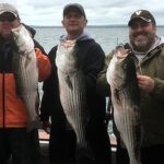
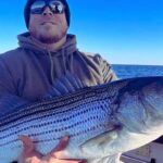
The fishing calendar in Barnegat is dictated by the migrations. The spring arrival of striped bass in the back bays usually kicks off the season, with anglers focusing on the sod banks and bridge pilings. As waters warm, the fluke (summer flounder) season takes center stage, with the channels leading to Barnegat Inlet becoming the focal point of the fleet. The late summer and early fall bring the "mullet run," a chaotic and exciting time when baitfish pour out of the estuaries, pursued by bluefish and bass.
Winter brings a quiet solitude to the region. While many boats are hauled, the dedicated surf casters and those willing to brave the cold can find holdover bass in the deeper channels. The Holgate Wilderness Area becomes a prime destination during these colder months (Sept-March) when it is open to vehicle traffic. This is when the true "salt" of the local angling community is most visible, working the suds in heavy neoprene waders.
Timing your day is crucial. In the summer months, the "sea breeze" effect is pronounced. The mornings may start dead calm, but by 11:00 AM, a stiff southerly wind often kicks up, chopping up the bay and making drift fishing difficult. Experienced captains plan their sight fishing or shallow water excursions for the early morning window to beat the wind. Conversely, the late afternoon wind often dies down just before sunset, offering a "magic hour" window that can be incredibly productive for topwater action.
Contact Information & Resources
For the most current information on access and conditions, direct communication with the managing agencies is recommended. The Edwin B. Forsythe National Wildlife Refuge headquarters can be reached at 609-652-1665 or via email at forsythe@fws.gov. They are the authority on current gate times and trail closures. For inquiries regarding the Jacques Cousteau National Estuarine Research Reserve, contact them at 609-812-0649 x 206. The New Jersey Pinelands Commission can be reached at (609) 894-7300 for questions regarding the broader reserve area.
Safety on these waters is the responsibility of the captain. In an emergency, the United States Coast Guard monitors VHF Channel 16. However, given the remote nature of the salt marshes, cell service can be spotty in the deep creeks. A VHF radio is standard equipment for any vessel leaving the dock. Always file a float plan, especially when fishing the expansive and isolated backwaters of the reserve.
For precise locations, real-time wind conditions, and detailed interactive maps of the boat ramps and bait shops mentioned above, consult the live dashboard and widgets below.

Leave a Reply