


The Ecological Crossroads of the Jersey Shore
Situated at a pivotal intersection of the Atlantic Ocean and the extensive wetland systems of New Jersey, Sea Isle City offers a fishery defined by its ecological complexity rather than just its beachfront. While many anglers associate the Jersey Shore solely with surfcasting and boardwalks, the true value of this location for the serious sportsman lies in its proximity to the Great Egg Harbor National Wild and Scenic River and the Cape May National Wildlife Refuge. This is not merely a vacation harbor; it is a critical biological funnel where the nutrient-rich outflow of the Pinelands meets the open ocean, creating a feeding ground that supports over 300 bird species and a robust population of migratory fish and shellfish.
The atmosphere here shifts distinctly from the manicured tourism of the north to a more rugged, nature-centric experience. To the west, the landscape is dominated by the 129-mile river system flowing through the Pinelands National Reserve, a region historically used by privateers during the American Revolution to hide their vessels. Today, that same topography provides experienced captains with intricate back-bay channels and salt meadows that hold game fish seeking refuge and forage. The vibe is less about glitzy marinas and more about understanding the subtle rhythms of tidal marshes and estuarine flows.
For the expert angler, the primary draw is the diversity of water. You are positioned to exploit the "migratory funnel" effect of the Cape May Peninsula. As species move south along the coast, they are concentrated by the geography, forced to linger in these waters to feed before crossing the 12-mile stretch of the Delaware Bay. Whether targeting resident shellfish in the backwaters or intercepting migratory finfish runs along the oceanfront, success here requires a tactical understanding of how these protected federal lands influence water quality and bait movement.
Access & Getting There
Reaching the prime fishing grounds around Sea Isle City generally involves navigating the Garden State Parkway, the primary artery feeding the Jersey Shore. For those towing vessels, the approach is straightforward, but traffic patterns can be deceptive during the summer high season. The most direct route to the southern refuge areas typically involves Exit 10, heading west toward Cape May Court House. Seasoned drivers know that while the highway moves fast, the local arteries like Route 50 and Ocean Drive can become bottlenecks, particularly when drawbridges are active or during peak beach ingress times on Friday evenings.
💡 Captain's Tip: Trailer Strategy
While street parking is common, trailer parking is scarce in the city center. The unnamed boat ramps located at coordinates 39.125 and 39.194 are indicated to have trailer parking availability. verify these spots early, as public lots like the Stone Harbor Public Parking (7.7 miles away) do not accommodate trailers.
Launch realities in this region are dictated by the tide and the specific designation of the water. The Great Egg Harbor River offers official boat access points managed effectively for recreational use. However, navigating to the launch at Estell Manor Park requires a drive inland, approximately 3.5 miles south of Mays Landing off Route 50. This site is roughly 17 miles west of Atlantic City. The infrastructure here is maintained by local jurisdictions under the umbrella of the National Park Service, generally ensuring a higher standard of maintenance than some neglected municipal ramps. However, the distance from the inlet means you are committing to a back-bay or riverine session rather than an ocean run.
Weather contingencies are critical when planning an approach to the Cape May National Wildlife Refuge areas. The geography that concentrates migratory birds—the funnel shape of the peninsula—also interacts with wind patterns. When northerly or northeasterly winds howl, the Delaware Bay crossing becomes treacherous, and wildlife (including baitfish) tends to stack up on the New Jersey side. This is often the most productive time to fish, provided you can find a leeward launch. The refuge access points near Kimbles Beach Road offer entry into these sensitive zones, but accessibility can be compromised by coastal flooding during new and full moon tides.
Parking requires a calculated approach. While there are highly-rated facilities like Park Place Parking and P3 Parking Lot, these are substantial distances away (over 19 miles) toward Atlantic City and Mays Landing. Locally, your options are tighter. The Municipal Parking - Beta Lot and Delta Lot in Ocean City operate from 7:00 AM to 7:00 PM. This schedule is often incompatible with the "dawn patrol" schedule of serious anglers who need to be on the water before sunrise. Consequently, securing a spot at one of the dedicated boat ramps with 24-hour access is essential for early morning sorties.
Sea Isle City Pre-Trip Checklist
Facilities & Amenities
The local infrastructure around Sea Isle City supports a serious fishing culture, but the amenities are spread out across the neighboring barrier islands. You will not find a condensed "fishing village" center; rather, you must know which shop specializes in your specific needs. For general provisioning and bait, Tight Lines Bait and Tackle in Somers Point is a reliable hub. Crucially, they open at 6:00 AM most days, allowing captains to stock up on fresh bait before the morning bite peaks. Similarly, Hands Too Bait and Tackle in Cape May maintains early hours, opening at 6:00 AM, servicing the southern end of the fishery.
For those chasing big game or requiring specialized equipment, Fin-atics Marine Supply Ltd., Inc. in Ocean City is the standout logistics partner. Unlike standard bait shops, they are noted for a "specialized heavy tackle inventory." If you need to re-spool a 50-wide or replace outrigger clips mid-trip, this is your destination. However, be aware of their operating hours; they open at 9:00 AM, which is effectively mid-day for the offshore crowd. Planning your gear needs the day before is mandatory when relying on their inventory.
💡 Captain's Tip: The Gear Gap
Note the distance between amenities. Sea Isle City sits in a pocket between the major hubs of Ocean City (10 miles north) and Cape May (17 miles south). There is a lack of immediate heavy-tackle shops in the immediate vicinity. Fuel up and buy ice on the highway before crossing the causeway to avoid backtracking.
The charter fleet in this region is robust and versatile, reflecting the dual nature of the fishery (back-bay and offshore). Operators like Moover Fishing Adventures and Badfish Fishing Charters are listed with "Open 24 hours" availability, suggesting a willingness to fish the tides rather than the clock—a hallmark of serious skippers who understand that striped bass do not adhere to a 9-to-5 schedule. Salty Grunt Sportfishing out of Cape May and Kott-the-Limit Sport Fishing Charters in Ocean City round out a fleet that is capable of handling everything from flounder drifting to canyon runs.
Lodging options here offer a unique dive into the region's history. The Caribbean Motel in Wildwood Crest is not just a place to sleep; it is a registered historic site representing the "Doo Wop" era of the 1950s. Built in 1957 with a futuristic ramp and plastic palm trees, it offers a stark, nostalgic contrast to modern chain hotels. For the angler towing a boat who prefers more space, campgrounds like Little Oaks Campground and Ocean Isle Campground in Cape May Court House and Ocean View provide logistical flexibility, often with more room for trailer maneuvering than the cramped motel lots on the barrier islands.
Permits, Regulations & Fees
Navigating the regulatory landscape here requires an appreciation for the federal protections in place. While the State Fishing Agency manages the general fishing regulations (size limits, bag limits, and seasons), the overlay of federal land adds a layer of responsibility. The Great Egg Harbor River is a National Wild and Scenic River, a designation that aims to preserve its free-flowing condition and water quality. This status protects the habitat that makes the fishing so productive, particularly for spawning fish and benthic invertebrates.
The Cape May National Wildlife Refuge presents specific zoning considerations. Established as a "Flagship Project" of the North American Waterfowl Management Plan, this area is designated as a Wetland of International Importance. While fishing is a permitted priority public use, it must be conducted without disturbing the critical habitat for the 317 bird species that utilize the refuge. This includes respecting "Kapu" style restrictions on entering nesting areas or trampling dune vegetation. The refuge supports 42 mammal species and 55 reptile species; anglers are guests in their home.
There are generally no special access permits required for recreational fishing in the open waters of the refuge or the river, provided you hold the standard state registration. However, commercial activities or large group gatherings often require Special Use Permits. It is vital to recognize that local jurisdictions administer the lands surrounding the river, meaning parking rules and beach access fees (beach tags) may vary significantly as you cross from Sea Isle City into Strathmere or Avalon. Always check the signage at the specific ramp or beach access point, as municipal ordinances regarding surf fishing hours can change seasonally.
Events & Seasonal Information
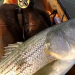
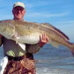
The biological rhythm of Sea Isle City is dictated by migration. The area is globally recognized for the fall migration, where the unique configuration of the peninsula concentrates wildlife. For the angler, this signals the "mullet run" and the subsequent arrival of predatory game fish in the surf and back bays. This is the high season for surfcasters, typically peaking from late September through November, when the cooling water triggers a mass exodus of baitfish from the estuaries.
💡 Captain's Tip: Wind Direction
The local topography creates a unique wind dynamic. When winds favor a crossing of the Delaware Bay, the action can slow as bait moves out. Conversely, adverse winds that stall the bird migration often stall the bait migration, creating "blitz" conditions along the beachfront. Watch the bird forecasts as closely as the marine weather.
Summer brings a different cadence, characterized by the "dawn patrol." With bait shops like Tight Lines opening at 6:00 AM, the culture here is to be on the water before the recreational boat traffic and the midday trade winds pick up. The summer months also see the height of the offshore tournament season, where the focus shifts to the canyons for billfish and tuna. While the specific tournament dates fluctuate, the heavy traffic at fuel docks and the scarcity of transient slips are predictable features of July and August.
Winter is quiet but not dead. The resident populations of shellfish and certain cold-water species in the Great Egg Harbor River system provide opportunities for the hardy. However, facilities shrink considerably; many bait shops reduce hours or close, and municipal water at boat ramps may be shut off to prevent freezing. The serious winter angler here is self-sufficient, carrying their own fresh water and reliable frozen bait.
Contact Information & Resources
For official information regarding river conditions and access status, the National Park Service manages the Great Egg Harbor National Scenic and Recreational River. Inquiries can be directed to the Northeast Region Office. For specific questions regarding the refuge, the Cape May National Wildlife Refuge headquarters is located at 24 Kimbles Beach Road in Cape May Court House, reachable at 609-463-0994. They are the authority on current closures regarding bird nesting or habitat restoration.
Safety in these waters is paramount. The mix of ocean swells and inlet currents requires vigilance. In an emergency, standard marine VHF channels should be monitored. For non-emergency logistical help, the Historic Hotels of America can assist with reservations at the Caribbean Motel via 800-678-8946. Always have a float plan filed with a shore contact, especially when fishing the solitary stretches of the salt marsh.
For precise locations, real-time wind conditions, and detailed bathymetry of the channels mentioned, consult the live dashboard and interactive maps below.
Leave a Reply