We are currently deep into the early summer transition across the New Jersey coastline. Water temperatures in the back bays and tidal estuaries have comfortably climbed into the low-to-mid 60s, breathing life into shallow mudflats and accelerating the metabolism of our resident and migratory species. Ocean surf temperatures are lagging slightly behind but are clean and warming.
Conditions are highly favorable for back-bay, inlet, and nearshore reef fishing. However, anglers must pay strict attention to the daily summer wind patterns. The classic mid-morning "sea breeze" effect is in full swing, often turning the open bays and inlet mouths choppy by 11:00 AM. Small craft operators should target the dawn patrol window for glassy conditions and plan to retreat to the sheltered lee of the sedge islands when the southwesterly winds aggressively build in the afternoon.
From the editor
Tired of fishing with strangers you can’t trust?
Nautrek is the first social network for serious anglers — verified partners, real trips, cost splitting and intel sharing without burning your spots. Private beta now open.
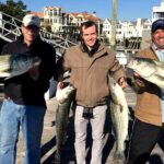
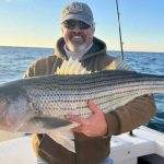
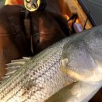
Summer Flounder are the undisputed kings of the back bays right now. They have aggressively pushed into the inlet channels, shallow bays, and tidal thoroughfares to take advantage of the warming water and abundant forage. Simultaneously, resident and migratory Striped Bass are actively staging around bridge pilings, sod banks, and inlet mouths to intercept bait dropping out of the marshes on the ebb tide.
Sleeper Pick: Black Drum & Black Sea Bass
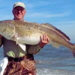
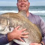
Often completely overshadowed by the striped bass hysteria, Black Drum are actively cruising the deeper holes inside the inlets and along the surf line. These heavyweights offer incredible battles and are currently taking baits with authority. Additionally, nearshore structures like the Great Egg Reef and local artificial wrecks are holding excellent numbers of "knothead" Black Sea Bass for those with a favorable marine forecast to make the short run offshore.
Baitfish Report: Match the Hatch
The estuaries are currently flushing out massive amounts of spearing (silversides), grass shrimp, and mud minnows (killies). We are also seeing the first scouting schools of peanut bunker and adult menhaden entering the major inlets. Predator fish are keyed in on these slender, 3-to-5-inch baitfish profiles. If you are throwing artificials, you must match the hatch with small, stout swimbaits or slender jerkbaits.
TACTICAL STRATEGY
Where to Fish
Focus your efforts on the tidal thoroughfares behind Barnegat Light, the sod banks of the Great Egg Harbor basin, and the dynamic channels of Corson's Inlet. For Fluke, target the 8 to 12-foot drop-offs adjacent to shallow, sun-warmed mudflats. Fluke will slide up into the 3 to 5-foot shallows to feed during the incoming tide, then retreat to the channel edges as the water drops. For Striped Bass, position your vessel up-current of major bridge stanchions or marsh creek drains, allowing your presentation to sweep naturally into the strike zone.
Lure Selection & Color
For Flounder: The gold standard right now is a 3/8oz to 1/2oz white or glow-colored bucktail jig, tipped with a 4-inch synthetic curly-tail grub (chartreuse or white are outproducing everything else). Fish this in tandem with a smaller 1/4oz teaser tied 18 inches above the main jig.
For Striped Bass: Throw 1/2oz leadhead jigs paired with 5-inch soft plastic jerkbaits in pearl or silver/blue to mimic the spearing. Slow-rolled swimming plugs like crystal minnow imitations are also highly effective at first light.
Bait & Rigging
If you prefer soaking bait, live spot or jumbo killies fished on a traditional three-way bottom rig will absolutely crush the larger doormat Fluke. For Black Drum, a fresh surf clam threaded onto an 8/0 circle hook on a fish-finder rig is the ticket. Keep the bait stationary in the deeper, 15 to 25-foot holes near the inlet mouths.
Optimal Timing
The golden window is the first three hours of the outgoing tide, especially when it aligns with dawn or dusk. The outgoing water flushes warm, bait-rich water from the back marshes into the main channels, triggering aggressive feeding windows before the midday sun drives fish deep.
Pro Tip:When jigging for Fluke, your line must remain completely vertical. If the wind or tide is sweeping your bucktail out at a harsh angle, you are out of the strike zone. Increase your jig weight incrementally until you can feel the bottom with a rhythmic "tap-tap" directly beneath your rod tip.
Pro Tip:Striped Bass are highly lethargic when water temperatures fluctuate. If the bite shuts down after a cold rain or upwelling, switch from fast-moving swimbaits to dead-sticking bloodworms or clam bellies near the warmer water outflows.
REGULATIONS SNAPSHOT
New Jersey recreational saltwater regulations are strictly enforced. Here is the current baseline for your primary targets:
Species
Minimum Size
Bag Limit
Season Status
Summer Flounder (Fluke)
18 inches
3 per person
Open
Striped Bass
28 to 31 inches (Slot)
1 per person
Open (Circle hooks required for bait)
Black Sea Bass
12.5 inches
10 per person
Open (Limit drops to 1 fish late June)
Bluefish
No Minimum
5 per person (Shore/Private)
Open
Note: Striped Bass measurements are strictly a slot limit. Any fish under 28 inches or over 31 inches must be safely released immediately. "Total length" is measured from the tip of the snout to the tip of the pinched tail. Always verify with the NJDEP Marine Digest for special zone exceptions like Island Beach State Park or Delaware Bay.
REGIONAL ALTERNATIVE
The Upriver Retreat
If coastal winds are howling out of the south, the ground swell is up, and the main inlets are completely blown out, do not cancel your trip—retreat upriver. The Great Egg Harbor River, the Mullica River, and the neighboring Tuckahoe River offer miles of highly sheltered, brackish water that remains incredibly productive.
Target Species: White Perch and holdover Striped Bass.
Tactical Approach: The dense tree lines and winding marsh banks block heavy winds, providing a glass-calm surface even when the ocean is churning. Target the deeper river bends and channel holes using grass shrimp on a simple top-and-bottom rig for White Perch. For upriver Stripers, throw small topwater poppers tight to the sod banks right at dawn, or drift fresh clam baits in the deep channel swings.
Pro Tip:Saltwater purists often overlook the brackish water transition zones, but these areas act as a sanctuary for both bait and gamefish during volatile marine weather. Downsize your tackle to light-power spinning gear and 10-pound braid to maximize your presentation in these calmer waters.
Tight lines!
Editor's Choice: Must-Have Gear
FISHINGSIR Next-Gen Waterproof Chest Waders
★★★★★4.4 (7,370+ reviews)
2-Ply Tech: Upgraded nylon with 2.5x higher density than standard fabrics.
100% Waterproof: Lab-approved intrusion resistance with taped visible seams.
Ultra-Lightweight: Designed for all-day comfort while hunting or fishing.
As an Amazon Associate I earn from qualifying purchases. #ad
Loading forecast...
Live Fishing Conditions: Tides, Weather & Waves
Get real‑time tides, marine weather, swell and solunar activity for each spot so you know exactly when conditions line up for your best chance at a bite.
🎣
NJ Saltwater
Loading coordinates...
🌤️
WEATHER CONDITIONS
--°F
--°C
Loading...
🌡️
Feels Like--°F--°C
💧
Humidity--%
💨
Wind-- mph-- km/h
🧭
Direction--
📊
Pressure-- inHg-- hPa
☀️
UV Index--
🌊
MARINE CONDITIONS
🌊Wave Height
-- ft
-- m
Loading...
🧭Wave Direction
--°
Loading...
⏱️Wave Period
-- s
Loading...
📈Tide Status
-- ft
-- m
Loading...
🌙
LUNAR & SOLUNAR
🌕
Loading...
Illumination: --%
Major Period--:-- - --:----:-- - --:--
Minor Period--:-- - --:----:-- - --:--
🌅Sunrise--:--
🌇Sunset--:--
📅
24-HOUR FORECAST
Loading fishing conditions...
Fishing Spots Map
🎣
Book a Fishing Charter near NJ Saltwater Fishing Report Today 🎣
Local guides & charters. Verified captains, instant booking, best price guaranteed.
There was an error loading the map. Please try refreshing the page.
Info
Local Access & Facilities
The coastal and estuarine waters surrounding Margate City, New Jersey offer a complex, highly productive environment for serious saltwater anglers. This region seamlessly transitions from manicured urban access points to the rugged, protected wetlands of the Pinelands National Reserve. Seasoned skippers know that mastering this zone requires understanding the delicate balance between the back-bay tidal movements and the open Atlantic swells.
Whether you are gearing up for heavy tackle offshore pursuits or navigating the intricate 129-mile system of the Great Egg Harbor River, the logistical realities here demand meticulous planning. The local infrastructure supports everything from family-friendly shore casting to heavy-duty sportfishing operations. Navigating the patchwork of municipal parking, tidal ramps, and strictly enforced wildlife refuges separates the weekend warriors from the pros.
This area is steeped in maritime history, serving as a tactical hideout for privateers during the American Revolution. Today, the pristine backwaters and barrier islands provide world-class sanctuary for both migratory birds and serious anglers. Success in these waters requires adapting your launch strategies to the shifting tides, strict municipal parking hours, and complex seasonal access rules.
Access & Getting There
Getting to the best water means navigating a mix of coastal highways and local avenues. For those targeting the pristine backwaters, access via Route 50 near Mays Landing puts you directly into the Great Egg Harbor River system. If you are launching closer to the salt, Seaview Dock sits just 2.9 miles from the Margate City center. Navigating a heavy boat trailer through the morning coastal traffic requires patience, especially during peak summer migrations.
When the ocean swells make the outside inlets treacherous, the vast Mullica River-Great Bay ecosystem provides vital sheltered backwaters. This area allows vessels to find protected water even when the coastal winds howl. The Jacques Cousteau National Estuarine Research Reserve expands its boundaries seaward to the Atlantic Ocean, offering numerous protected coves. Always check your weather routing and utilize these estuarine bailouts when the Atlantic turns hostile.
Parking strategy is arguably the most critical logistical hurdle for the dawn patrol angler. Park Place Parking in Atlantic City is a premium asset, offering 24-hour access just 5.2 miles from the Margate epicenter. Conversely, the municipal lots in Ocean City, including the Delta, Beta, and Echo Lots, enforce strict hours from 7:00 AM to 7:00 PM. Utilizing the P3 Parking Lot on Absegami Road is another option, though it sits 13 miles inland.
💡 Captain's Tip: Dawn Patrol Parking
If your charter or personal launch requires a pre-dawn arrival, completely avoid the Ocean City municipal lots. Rely on Park Place Parking for 24-hour access or secure street parking near your marina to avoid being locked behind a gate until 7:00 AM.
For shore anglers looking for diverse terrain, the Edwin B. Forsythe National Wildlife Refuge offers multiple specialized access points. The deCamp Wildlife Trail can be reached via the Garden State Parkway to Mantoloking Road in Brick Township. Further south, the Barnegat Observation Platform off Bay Shore Drive provides excellent scouting vantage points. Always plan your route based on real-time highway congestion along the Garden State Parkway.
NJ Saltwater Pre-Trip Checklist
Facilities & Amenities
The caliber of local tackle shops reflects the serious nature of the local fishing fleet. Fin-atics Marine Supply in Ocean City is the undisputed hub for specialized heavy tackle inventory. For those needing last-minute gear closer to Margate, Ship Shop Bait & Tackle is conveniently located 2.4 miles away in Ventnor City. However, skippers must note that Ship Shop does not open until 8:00 AM, making it unsuitable for early departures.
If your strategy requires fresh bait before the sun comes up, logistics become slightly more complicated. Boulevard Bait & Tackle in Ocean View opens at 6:30 AM, offering a slight edge for early departures, though it requires a 15.4-mile drive. Knowing these operating hours is critical to prevent wasting precious morning tide movements waiting for a shop door to unlock.
The local charter fleet is heavily stacked with top-tier operators accustomed to both back-bay and offshore runs. Flat out fishin Charters is located mere feet from the Margate center, providing ultimate convenience with 24-hour operations. For those looking for specialized sportfishing, Euphoria Sportfishing operates out of nearby Longport, just 1.4 miles down the boulevard. Further south, Badfish Fishing Charters runs out of Somers Point.
Facility Name
Type
Distance
Early Access Notes
Fin-atics Marine Supply
Heavy Tackle
4.9 miles
Opens 9:00 AM
Boulevard Bait & Tackle
Bait Shop
15.4 miles
Opens 6:30 AM
Flat out fishin Charters
Charter
1156 feet
24 Hour Operation
Euphoria Sportfishing
Charter
1.4 miles
24 Hour Operation
For multi-day excursions, lodging options range from upscale to utilitarian. Marriott's Fairway Villas offers premium accommodations 8.9 miles inland. Hardcore anglers hauling their own rigs often prefer the Ocean Isle Campground or Little Oaks Campground for easier trailer maneuvering. Belhaven Lake RV Resort is another excellent option for larger setups, located 20.9 miles from the primary saltwater access points.
💡 Captain's Tip: Bait Logistics
Do not rely on securing live bait near the Margate ramps before sunrise. Purchase your bait the afternoon prior, or plan the 15-mile detour to Boulevard Bait & Tackle to ensure you are fully armed for the morning bite.
Permits, Regulations & Fees
Operating in these waters requires strict adherence to environmental regulations managed by the State Fishing Agency. The crown jewel of local conservation is the Edwin B. Forsythe National Wildlife Refuge, encompassing over 48,000 acres of tidal wetlands and salt marshes. Originally established as the distinct Brigantine and Barnegat refuges, they were combined in 1984 to protect vital migratory water birds along the Atlantic Flyway.
Specific zones within the refuge demand specialized knowledge of seasonal closures and permit requirements. The Holgate Wilderness Area is a prime example of this seasonal shift. It is only open to walking and surf fishing vehicles from September 1 to March 31. Accessing this 3.5-mile stretch of beach requires a specific buggy permit obtained directly from Long Beach Township.
Beyond legal compliance, operating here requires deep cultural respect. The refuge and surrounding estuaries lie on the indigenous homelands of the Lenni Lenape people, recognized as the original stewards of this seafood-rich environment. Anglers are expected to treat the barrier islands, shallow coves, and delicate salt marshes with the highest degree of stewardship.
The Jacques Cousteau National Estuarine Research Reserve is heavily protected, with little more than one percent of the reserve subjected to human development. Exploring areas like Graveling Point or Scott's Landing requires staying strictly on designated paths. Driving off-road in non-permitted wetland zones will result in severe federal fines and damage to the very ecosystem that supports the local fishery.
💡 Captain's Tip: Holgate Surf Permits
Do not attempt to drive the Holgate Wilderness Area without prior authorization. You must contact Long Beach Township at 609-361-1200 well in advance to secure your seasonal beach buggy permit for winter surf fishing.
Events & Seasonal Information
The rhythms of this fishery are entirely dictated by the seasonal migrations of both game species and waterfowl. During the warmer months, the coastal margins and barrier islands are bustling with recreational boaters. As the season transitions into winter, areas like the Holgate Wilderness Area open up for isolated, rugged surf fishing opportunities.
The Jacques Cousteau National Estuarine Research Reserve remains one of the least disturbed estuaries in the densely populated Northeast corridor. Seasonal weather patterns significantly alter water clarity and tidal flows across its vast 115,000-acre footprint. Seasoned skippers know to time their back-bay trips with the incoming tide to maximize clean ocean water pushing into the river systems.
For anglers looking to expand their local knowledge during blown-out days, the Life on the Edge Interpretive Center in Tuckerton is open daily from 10:00 AM to 5:00 PM. Located inside the Tuckerton Seaport Baymans Museum, it offers deep insights into the estuarine environment. Additionally, visitors can get their Passport Stamp Books stamped at the Fox Nature Center near the Great Egg Harbor River.
Contact Information & Resources
Multiple federal and state agencies oversee this complex network of waterways. The National Park Service administers the Great Egg Harbor River system, while the US Fish & Wildlife Service manages the sprawling Forsythe Refuge. Knowing which jurisdiction you are navigating is critical for maintaining compliance and ensuring rapid response during an emergency.
Self-reliance is paramount when navigating the shifting sandbars of the New Jersey coast. Always check real-time weather and ocean conditions before leaving the dock, as the inlets can become incredibly dangerous during an outgoing tide against a strong onshore wind. Ensure you wear appropriate footwear for slippery ramps and utilize heavy sun protection for long days on the water.
For precise locations, facility hours, and real-time conditions, consult the live dashboard and maps below.
Our spot reports combine data-driven forecasts with curated local information. The forecast is generated by our proprietary Fishing Score algorithm (0–100%), which analyzes real-time data from Open-Meteo API, validated against NOAA CO-OPS tide gauges and USGS water-monitoring stations. The model weights tide dynamics (35%), wave energy (25%), wind patterns (20%) and time of day (20%)—factors shown to influence fish feeding behavior through marine-biology research and decades of charter log data.
Access, facilities and services information for each fishing spot is sourced from official datasets such as Recreation.gov (RIDB), state park & wildlife agencies, and geospatial providers like Google Maps. These sections undergo scheduled re-validation every 3–6 months to ensure that boat ramps, park access, contact details and local services remain accurate.
Narrative sections (catches, seasonal behavior, local tips) are synthesized from these data sources and refined following the Fishing Reports Today editorial guidelines, combining bibliographic research from ichthyology and oceanography with expert angler experience. Our team reviews reports on a regular basis, while the forecast model itself updates every 6 hours for real-time accuracy.
⚠️ Important: Always verify current local regulations, access restrictions and weather conditions before fishing. These reports are intended as a planning aid, not a guarantee of catches or safety. When in doubt, contact local authorities or park managers listed on the page.
To provide the best experiences, we use technologies like cookies to store and/or access device information. Consenting to these technologies will allow us to process data such as browsing behavior or unique IDs on this site. Not consenting or withdrawing consent, may adversely affect certain features and functions.
Functional Always active
The technical storage or access is strictly necessary for the legitimate purpose of enabling the use of a specific service explicitly requested by the subscriber or user, or for the sole purpose of carrying out the transmission of a communication over an electronic communications network.
Preferences
The technical storage or access is necessary for the legitimate purpose of storing preferences that are not requested by the subscriber or user.
Statistics
The technical storage or access that is used exclusively for statistical purposes.The technical storage or access that is used exclusively for anonymous statistical purposes. Without a subpoena, voluntary compliance on the part of your Internet Service Provider, or additional records from a third party, information stored or retrieved for this purpose alone cannot usually be used to identify you.
Marketing & Affiliates
The technical storage or access is required to create user profiles to send advertising, or to track the user on a website or across several websites for similar marketing purposes, including affiliate tracking for products recommended in our reports.


Leave a Reply