0%

Kidney Lake Utah Fishing Report Today 🎣

7 months ago · Updated 1 month ago

Welcome to the ultimate guide's breakdown for Kidney Lake, nestled high in Utah's breathtaking Uinta Mountains. As a Senior Fishing Editor and local pro guide, I monitor these high-alpine waters with a microscopic lens. Kidney Lake is a sprawling 189-acre reservoir situated in Duchesne County, surrounded by dense alpine forests and towering peaks. It offers pristine, crystal-clear angling, but its extreme elevation dictates every single tactical decision we make. Whether you are planning a hardwater expedition or preparing your gear for the glorious ice-out period, here is your comprehensive, professional-grade intelligence report.

1. GO/NO-GO STATUS

Verdict: UNSAFE - TRY ALTERNATIVE (For Standard Vehicles) / CAUTION (For Tracked Vehicle Access)

We are currently navigating the volatile late-winter to early-spring transition in the High Uintas. At this extreme elevation, winter completely rules the landscape long after the lower valleys have thawed. The primary access trails and forest service roads leading to the basin are buried under massive, drifting snowpack and remain entirely impassable to standard trucks, SUVs, or foot traffic.

From the editor

Tired of fishing with strangers you can’t trust?

Nautrek is the first social network for serious anglers — verified partners, real trips, cost splitting and intel sharing without burning your spots. Private beta now open.

Join the Waitlist — Free → 100+ anglers on the list
Nautrek App

Ice Conditions: For those elite anglers accessing the lake via snowmobile, tracked UTV, or multi-day backcountry ski treks, expect anywhere from 18 to 24 inches of hard

clear ice, capped with a varying layer of packed snow and slush. While the main sheet remains solid, always drill test holes as you venture out. Be hyper-vigilant near the inlets and structural pinch points where moving water can compromise ice integrity from below.

2. CURRENT WATER & WEATHER CONDITIONS

Water Temp: Hovering near 34-36°F under the ice.
Water Clarity: Crystal clear. Where the snow cover is blown clear, you can expect visibility up to 15 feet down.
Weather: Unpredictable and punishing. Expect wild temperature swings. Morning lows routinely plunge into the single digits, while intense high-altitude midday sun pushes surface temps into the upper 30s, creating sloppy surface conditions. Wind is a constant factor in this basin; pack a heavy-duty hub shelter with heavy ice anchors if you plan to stay on the hardwater for more than an hour.

3. SPECIES TARGETS & ACTIVITY LEVELS

Kidney Lake is predominantly a pristine trout fishery, and right now, metabolic rates are shifting as the days slowly lengthen.

  • Brook Trout (High Activity): The brookies are currently the most aggressive feeders in the lake. They are actively patrolling the shallow flats and rocky shorelines looking for easy, high-protein meals.
  • Cutthroat Trout (Moderate Activity): Cruising slightly deeper, the native cutthroats are starting to stage near the primary drop-offs. They require a bit more finesse and patience to coax into biting.
  • Rainbow Trout (Moderate Activity): Rainbows are suspended in the middle of the water column. They are highly responsive to flash but can be notoriously short-striking during cold fronts.

4. TACTICAL BREAKDOWN & LURE SELECTION

Because the water is incredibly clear under the ice, stealth is paramount. Heavy fluorocarbon or braided lines will get you rejected instantly. Downsize your presentation, spool up with 2lb to 4lb fluorocarbon tippet, and focus on realistic profiles.

Jigging: Start with micro tungsten jigs (1/32 or 1/64 oz) in natural colors—black, olive, or subtle glow patterns for low-light conditions. Tipping your jig with a wax worm, mealworm, or a small piece of nightcrawler is non-negotiable for sealing the deal. Work the bottom two feet of the water column for brookies, using a subtle quiver rather than aggressive, sweeping rips.

Dead-Sticking: Set up a secondary rod (where regulations permit) with a small teardrop jig or a bare hook and a live bait presentation suspended halfway down the water column. This is your insurance policy for cruising rainbows and cutthroats that are wary of the erratic jigging motion.

Spoons: Small flutter spoons (like a 1/12 oz Kastmaster or Swedish Pimple) in silver or copper can be highly effective for calling fish in from a distance. However, be prepared to immediately drop down a micro-jig if they come in hot on your sonar and suddenly refuse the larger hardware.

5. HOTSPOTS & ZONES

The Dam Face: The deeper water near the dam structure is holding schools of cutthroats. Look for the transitional breaks dropping from 10 to 20 feet. Fish the edges of these breaks.

Northern Inlets: Brook trout heaven. Focus on the 4-to-8-foot depth range where the incoming (though currently frozen or trickling) water creates a slight current and oxygenates the surrounding area. Again, exercise extreme caution regarding ice thickness here.

The Eastern Flats: A great mid-morning zone when the sun penetrates the ice. The deeper weed beds are dying off, but the edges still harbor aquatic insects that the rainbows and brookies graze on throughout the day.

6. PRO GUIDE TIPS FOR THE UPCOMING TRANSITION

As we march toward the eventual ice-out over the next month, keep a close eye on the shoreline edges. The ice will pull away from the banks first, creating dangerous "moats." If you are planning a late-ice trip, bring a spud bar, wear ice picks around your neck, and never fish alone. Once the ice-out officially begins, transition immediately to casting small Panther Martins or suspending midges right at the receding ice edge—that is where the most ferocious strikes of the entire year will happen.

Tight lines!

Editor's Choice: Must-Have Gear

FISHINGSIR Next-Gen Waterproof Chest Waders

★★★★★ 4.4 (7,370+ reviews)
  • 2-Ply Tech: Upgraded nylon with 2.5x higher density than standard fabrics.
  • 100% Waterproof: Lab-approved intrusion resistance with taped visible seams.
  • Ultra-Lightweight: Designed for all-day comfort while hunting or fishing.
Check Availability on Amazon

✓ Amazon's Choice | 100+ bought last month

🛒 Tactical Gear for this Spot

Bandit Walleye Deep

Mandatory for reaching deep schools in 35-50ft mud flats.

Check Price on Amazon #ad

As an Amazon Associate I earn from qualifying purchases. #ad

🐟 Kidney Lake Utah

Species data is being updated for this location.

Check back soon for fishing forecasts.

Live Fishing Conditions: Tides, Weather & Waves

Get real‑time tides, marine weather, swell and solunar activity for each spot so you know exactly when conditions line up for your best chance at a bite.

🎣

Kidney Lake Utah

Loading coordinates...

🌤️

WEATHER CONDITIONS

Weather
-- °F
--°C

Loading...

🌡️
Feels Like --°F --°C
💧
Humidity --%
💨
Wind -- mph -- km/h
🧭
Direction --
📊
Pressure -- inHg -- hPa
☀️
UV Index --
🌊

MARINE CONDITIONS

🌊 Wave Height
-- ft
-- m
Loading...
🧭 Wave Direction
--°
Loading...
⏱️ Wave Period
-- s
Loading...
📈 Tide Status
-- ft
-- m
Loading...
🌙

LUNAR & SOLUNAR

🌕

Loading...

Illumination: --%

Major Period --:-- - --:-- --:-- - --:--
Minor Period --:-- - --:-- --:-- - --:--
🌅 Sunrise --:--
🌇 Sunset --:--
📅

24-HOUR FORECAST

Loading fishing conditions...

Fishing Spots Map

My location
Loading map...

Local Access & Facilities

Accessing the High Uintas Fishery

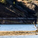
Located deep within the rugged beauty of the Uinta Mountains, the fishery surrounding Kidney Lake and the broader Rock Creek Drainage offers a quintessential high-elevation angling experience. This area is defined by its pristine alpine environment, sitting at an elevation of approximately 7,200 feet. Anglers here trade the convenience of urban harbors for the solitude of towering Ponderosa pines, aspen groves, and the rushing waters of Rock Creek.

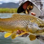
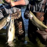
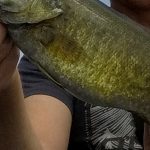
The atmosphere is strictly backcountry, appealing to fly fishermen and spin casters looking to target wild trout in a serene setting. The primary targets in these waters include Brown Trout, Brook Trout, and Rainbow Trout. While the location is remote, the infrastructure at key staging areas like Yellowpine provides a surprising level of comfort for a basecamp, bridging the gap between raw wilderness and accessible recreation.

This is not a fishery for heavy fiberglass boats or expansive trolling spreads. Instead, it is a haven for waders, bank fishermen, and those willing to hike into the High Uintas Wilderness. The cool mountain air and summer wildflowers create a stunning backdrop, but the rugged terrain demands respect and preparation from even the most seasoned outdoorsmen.

💡 Captain's Tip: Elevation Awareness

You are fishing at over 7,000 feet. Even in mid-summer, temperatures drop significantly after sunset. Pack heavy layers and ensure your vehicle's cooling system is up to the task of climbing the steep grades to reach the trailhead.

Access & Getting There

Reaching this section of the Ashley National Forest requires navigating mountain roads that transition from state highways to forest service routes. The primary approach begins from Highway 40 in Duchesne, Utah. From there, seasoned locals turn north onto Highway 87, traveling approximately 15 miles to the Mountain Home turnoff. The route continues for another 2.5 miles toward Mountain Home before a critical left turn at the Rock Creek Store.

From the store, the road winds roughly 15 miles deeper into the drainage to reach the primary access points. While the main roads are generally accessible, drivers should be aware of wildlife and narrowing lanes. For those towing trailers, note that the Yellowpine Campground loops are paved, but maneuvering large rigs can be tight in specific backcountry turnouts.

Parking is available at designated recreation sites. The Miners Gulch Fishing Parking site offers a specific staging area for anglers focusing on the stream sections. This facility is located approximately 4.6 miles from the main campground hub. If you are heading further up toward the Upper Stillwater Reservoir, be advised that access to the water there is currently restricted to hiking in, making vehicle security at the trailhead paramount.

💡 Captain's Tip: Launch Realities

There is no developed boat ramp at Kidney Lake itself. For boaters in the wider region, the Mirror Lake Boat Ramp is roughly 15.8 miles away, but for the immediate Rock Creek area, plan on wet-wading or shore fishing. Leave the heavy trailer at home unless you are hauling a camper.

Kidney Lake Utah Pre-Trip Checklist

Facilities & Amenities

Despite its remote feel, the basecamp infrastructure in the Rock Creek area is well-maintained. The primary hub is the Yellowpine Campground, which serves as the logistical heart of the fishery. Unlike many primitive mountain camps, Yellowpine offers paved driveway surfaces and accessible flush toilets, a luxury in this terrain. Drinking water is provided, and there is an on-site dump station for RV users.

For anglers requiring accommodation outside of a tent, the Mountain Home Lodge is located approximately 18.3 miles away, offering a roof and bed after a long day on the water. RV enthusiasts who cannot find a spot at Yellowpine should consider the Old Mill RV Park in Hanna, roughly 15.6 miles from the fishing grounds. This park operates 24 hours a day, making it a viable backup for late arrivals.

It is critical to note the "negative knowledge" for this area: there are no dedicated tackle shops or bait stores in the immediate vicinity of the water. While the Rock Creek Store is a landmark for directions, serious anglers should purchase all flies, lures, and bait in Duchesne or Salt Lake City before making the climb. Fuel opportunities are also non-existent once you pass the Mountain Home area, so top off your tank before leaving the highway.

Facility NameTypeDistanceKey Features
Yellowpine CampgroundCampground4.6 milesPaved sites, Flush Toilets, Dump Station, Max Vehicle 30'
Upper StillwaterCampground5.3 milesHigh elevation, Hiking access to reservoir
Miners GulchParking / Access4.6 milesStream access parking, undeveloped
Mountain Home LodgeLodging18.3 milesNearest lodge accommodation

Permits, Regulations & Fees

Fishing in the Ashley National Forest and the surrounding state waters falls under the jurisdiction of the Utah Division of Wildlife Resources. A valid Utah state fishing license is mandatory for all anglers. Because this area borders the High Uintas Wilderness, special attention must be paid to boundary markers. Wilderness areas often have stricter regulations regarding motorized equipment and bait usage to protect native cutthroat populations.

The Yellowpine Campground operates on a reservation system for many of its sites, including the popular double sites (Capacity 16) and single sites (Capacity 8). Fees are required for overnight stays. The campground includes specific "mandatory equipment" rules, likely regarding bear-safe storage or tent pad usage, to minimize environmental impact. Respecting these rules ensures the longevity of the resource and keeps the "Kapu" (sacred/forbidden) nature of the wilderness intact for future generations.

💡 Captain's Tip: Gear Restrictions

While general fishing is allowed, always check the current proclamation for Rock Creek. Specific stretches may be designated as artificial flies and lures only, particularly near the wilderness boundaries.

Events & Seasonal Information

The angling rhythm here is dictated entirely by the seasons of the Uinta Mountains. The window of opportunity is relatively short, typically running from late June through September. Winter snows can make access roads impassable well into the spring. Summer offers the best conditions, with "cool evenings" being a hallmark of the 7,200-foot elevation.

Whitewater rafting and kayaking opportunities on Rock Creek are seasonal, usually peaking during the spring runoff in May and June. For fishermen, the post-runoff period in July offers the clearest water and most active trout feeding patterns. Late afternoons often bring thunderstorms common to the high peaks, so the "dawn patrol" strategy is recommended to maximize fishing time before the weather turns.

Contact Information & Resources

The primary managing agency for the land and facilities is the Ashley National Forest. In the event of an emergency, cell service is spotty to non-existent in the drainage. Anglers should carry satellite communication devices or prepare for self-rescue. For campground issues, the camp hosts at Yellowpine are the immediate point of contact during the season.

  • Managing Agency: Ashley National Forest
  • District Office Phone: (435) 738-2482 (Referenced via Upper Stillwater)
  • Email: ljhaynes@fs.fed.us

For precise locations of the parking turnouts, specific campground loops, and real-time weather conditions at elevation, consult the live dashboard and interactive maps below.

🎣

Kidney Lake Utah

Utah • 40.5994, -110.6170
🅿️

Parking

1
Yurt parking
⭐ 4.4 24.3 mi
📍 FR002, Evanston, WY 82930, USA
🚗 Get Directions
🏠

Lodging

5
Old Mill RV Park
⭐ 5.0 15.6 mi
📍 41051 UT-35, Hanna, UT 84031, USA
🕒
Monday: Open 24 hours
Tuesday: Open 24 hours
Wednesday: Open 24 hours
Thursday: Open 24 hours
Friday: Open 24 hours
Saturday: Open 24 hours
Sunday: Open 24 hours
🚗 Get Directions
Mountain Home Lodge
⭐ 4.8 18.3 mi
📍 6801 N 21000 W, Mountain Home, UT 84051, USA
🕒
Monday: 8:00 AM – 8:00 PM
Tuesday: 8:00 AM – 8:00 PM
Wednesday: 8:00 AM – 8:00 PM
Thursday: 8:00 AM – 8:00 PM
Friday: 8:00 AM – 8:00 PM
Saturday: 8:00 AM – 8:00 PM
Sunday: Closed
🚗 Get Directions

Boat Ramps

2
🚻

Restrooms

3
👨‍👩‍👧‍👦

Family Friendly

2

Accessibility

Wheelchair Access

Not Confirmed

🐕

Pets Allowed

Not Confirmed

⚠️ Some accessibility info not officially confirmed. Please verify with location directly.

📍 Showing 13 facilities on map

📊

About Our Fishing Reports & Forecasts

Our spot reports combine data-driven forecasts with curated local information. The forecast is generated by our proprietary Fishing Score algorithm (0–100%), which analyzes real-time data from Open-Meteo API, validated against NOAA CO-OPS tide gauges and USGS water-monitoring stations. The model weights tide dynamics (35%), wave energy (25%), wind patterns (20%) and time of day (20%)—factors shown to influence fish feeding behavior through marine-biology research and decades of charter log data.

Access, facilities and services information for each fishing spot is sourced from official datasets such as Recreation.gov (RIDB), state park & wildlife agencies, and geospatial providers like Google Maps. These sections undergo scheduled re-validation every 3–6 months to ensure that boat ramps, park access, contact details and local services remain accurate.

Narrative sections (catches, seasonal behavior, local tips) are synthesized from these data sources and refined following the Fishing Reports Today editorial guidelines, combining bibliographic research from ichthyology and oceanography with expert angler experience. Our team reviews reports on a regular basis, while the forecast model itself updates every 6 hours for real-time accuracy.

⚠️ Important: Always verify current local regulations, access restrictions and weather conditions before fishing. These reports are intended as a planning aid, not a guarantee of catches or safety. When in doubt, contact local authorities or park managers listed on the page.

Learn more about our methodology & data sources

Leave a Reply

Your email address will not be published. Required fields are marked *