Tibble Fork Fishing Report Today 🎣
9 months ago · Updated 5 days ago

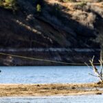
Tibble Fork Reservoir: Professional Fishing Report
1. GO/NO-GO STATUS
Verdict: GO
Current conditions at Tibble Fork Reservoir are prime for early summer angling. The ice has long since melted, and the water temperature is holding in the highly productive upper 50s. This is the optimal thermal window for trout species before the intense heat of late summer pushes them into deeper, lethargic patterns. Weather is stable with daytime highs comfortably in the mid-70s and light, manageable winds that will not disrupt casting or boat positioning.
Advisory: The primary challenge right now is not the weather, but the intense recreational pressure. Tibble Fork is a highly popular destination for paddleboarders, kayakers, and hikers. By mid-morning, the surface activity and noise can spook fish in the shallower flats. Furthermore, parking in the American Fork Canyon area fills up rapidly. Anglers must arrive before sunrise to secure a designated parking stall and capitalize on the undisturbed morning bite. Remember that parking in non-designated zones is strictly enforced and will result in towing.

2. SPECIES INTEL
Primary Target: Rainbow Trout
Stocked Rainbow Trout are the most abundant and active species in the reservoir right now. The state maintains healthy stocking numbers here, and these fish are currently cruising the upper water column during low-light hours. They are aggressive, schooling fish that respond well to both scent-based baits and flashy hardware.
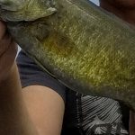
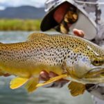
Sleeper Pick: Brown Trout
While most anglers are content catching stocker Rainbows, Tibble Fork holds a respectable population of holdover Brown Trout. These fish are far more wary, tend to be solitary, and hold tighter to structure. They often ambush prey from the deeper drop-offs near the dam or lurk in the undercut banks near the river inlets. Catching them requires a stealthier approach and a presentation that mimics wounded baitfish rather than synthetic dough baits.
Baitfish & Forage Report:
The primary forage base consists of aquatic macroinvertebrates—particularly midges, caddisflies, and emerging mayflies. As the canyon warms up, terrestrial insects like ants, beetles, and hoppers are beginning to blow onto the water surface from the surrounding pine and oak brush. Small baitfish and trout fry are also present, which the larger Brown and Cutthroat Trout actively hunt.
Pro Tip: When targeting the inlets, keep an eye out for feeding lanes—look for bubbles or foam floating in a continuous line. Trout will stack up just below these natural conveyor belts of food. Drifting a bait or nymph naturally through these lanes is a guaranteed way to increase your hookup ratio.
3. TACTICAL STRATEGY
To consistently pull fish out of Tibble Fork right now, you need to be precise with your location and timing. Generic casting into the middle of the lake will yield mixed results at best. The thermal dynamics of the reservoir mean that while the surface warms quickly under the midday sun, a distinct thermocline provides a cool, oxygenated sanctuary for the trout in the lower depths. Understanding this vertical migration is the key to extending your bite window.
Where to Target
Focus your efforts on the Northwest stream inlet and the Northeast river inlet. These areas provide a constant flow of cooler, oxygen-rich water that funnels natural forage directly into the reservoir. Position yourself adjacent to the current seams where the fast river water meets the still water of the lake. The trout will stack up in the slightly deeper water, typically the 8 to 12-foot range, just off the edge of these seams to ambush food.
As the sun rises and penetrates the water column, abandon the shallow inlets and move toward the dam face on the southern end. The water drops off sharply here. Work the 15 to 25-foot depth contours where the fish retreat to find thermal refuge from the midday sun.
Gear and Presentation
- Hardware/Lures: A 1/16oz to 1/8oz Kastmaster spoon in Silver/Blue or Gold is highly effective for covering water and locating aggressive Rainbows. If you are targeting the sleeper Brown Trout, switch to a Rapala Countdown (CD03 or CD05) in a natural trout or minnow pattern. Count it down to 10-15 feet and use an erratic twitch-pause retrieve.
- Bait Fishing: For a stationary approach, use Garlic-scented PowerBait in Chartreuse or Rainbow colors. Crucial rigging note: Do not fish it directly on the bottom where it will get lost in the silt. Use a sliding egg sinker rig with a 24-inch fluorocarbon leader so the buoyant bait floats just above the bottom debris. Alternatively, a live nightcrawler suspended 4-6 feet under a slip bobber works wonders near the inlets.
- Fly Fishing: With the recent insect activity, a dry-dropper rig is deadly. Tie on a highly visible size 14 Chubby Chernobyl or Elk Hair Caddis as your indicator, and trail a size 18 Zebra Midge (black with silver wire) or a bead-head Pheasant Tail nymph about 24 to 36 inches below it.
Pro Tip: The fish in Tibble Fork are highly pressure-sensitive due to the clear water and heavy foot traffic. Downsize your line to 4lb or even 2lb fluorocarbon for your leaders. Thick monofilament will result in short strikes or completely ignored baits.
Timing the Bite
The solunar forecast indicates peak activity windows occurring in the early morning hours. You want your lines in the water by dawn. The bite is aggressive from first light until about 9:00 AM. After 9:00 AM, the combination of direct sunlight and heavy recreational watercraft traffic will force the fish deep and shut down the shallow bite. A secondary, albeit shorter, feeding window opens up in the last hour of daylight just before dusk.
4. REGULATIONS SNAPSHOT
Compliance is critical. The US Forest Service and state wildlife officers actively patrol this area. Here is what you need to know before you cast:
| Regulation Category | Current Rule |
|---|---|
| Bag & Possession Limit | 4 Trout combined (includes Rainbow, Brown, Cutthroat, Brook, and hybrids). |
| Boating Restrictions | NO MOTORS. Internal combustion motors are strictly prohibited. Only non-motorized craft (kayaks, canoes, float tubes, paddleboards) are allowed. |
| Access Fees | Tibble Fork is located within the American Fork Canyon fee area. A recreation pass is required for parking. |
| Site Rules | No glass containers, no fires outside designated rings, and dogs must be kept on a leash at all times. |
Pro Tip: Always keep a tape measure and a pair of forceps on hand. If you are practicing catch-and-release, especially with the native Cutthroat or holdover Browns, handle the fish with wet hands and keep them in the water as much as possible to ensure their survival.
5. REGIONAL ALTERNATIVE
If you arrive at Tibble Fork and find the parking lot completely full, or if the paddleboard traffic has completely shut down the bite, do not pack up and go home. You have an excellent backup option just a short drive away.
Silver Lake Flat Reservoir
Located further up the canyon from Tibble Fork, Silver Lake Flat is a stunning alpine reservoir that sees a fraction of the pressure.
- Access: The drive requires traveling up a rugged, unpaved dirt road. While most SUVs and trucks can handle it easily, low-clearance passenger cars should proceed with extreme caution.
- Target Species: Brook Trout and Rainbow Trout. The Brook Trout here are beautifully colored and eager to bite.
- Tactical Approach: The water here is even colder and clearer than Tibble Fork. Stealth is paramount. Small inline spinners (like a size 0 Mepps Aglia) or small marabou jigs (1/32oz in olive or black) worked slowly along the rocky shorelines will produce strikes. Fly anglers should focus on terrestrial patterns like flying ants or small hopper patterns as the day warms up.
- Regulations: Similar to Tibble Fork, no internal combustion motors are allowed, and camping is restricted to designated areas.
Whether you are launching a float tube at dawn on Tibble Fork or making the trek up the dirt road to Silver Lake Flat, the early summer fishing in American Fork Canyon is hard to beat right now. Prepare your gear, set your alarm early, and enjoy the pristine mountain water.
Tight lines!

FISHINGSIR Next-Gen Waterproof Chest Waders
- 2-Ply Tech: Upgraded nylon with 2.5x higher density than standard fabrics.
- 100% Waterproof: Lab-approved intrusion resistance with taped visible seams.
- Ultra-Lightweight: Designed for all-day comfort while hunting or fishing.
✓ Amazon's Choice | 100+ bought last month
Bandit Walleye Deep
Mandatory for reaching deep schools in 35-50ft mud flats.
Check Price on Amazon #adAs an Amazon Associate I earn from qualifying purchases. #ad
Live Fishing Conditions: Tides, Weather & Waves
Get real‑time tides, marine weather, swell and solunar activity for each spot so you know exactly when conditions line up for your best chance at a bite.
Tibble Fork
Loading coordinates...
WEATHER CONDITIONS
Loading...
MARINE CONDITIONS
LUNAR & SOLUNAR
Loading...
Illumination: --%
24-HOUR FORECAST
Fishing Spots Map
Local guides & charters. Verified captains, instant booking, best price guaranteed.
Local Access & Facilities
Tibble Fork
Parking
Bait & Tackle
Fishing Charters
Lodging
Restrooms
Family Friendly
Accessibility
Wheelchair Access
Not Confirmed
Pets Allowed
Not Confirmed
⚠️ Some accessibility info not officially confirmed. Please verify with location directly.
Local guides & charters. Verified captains, instant booking, best price guaranteed.
Nearby Spots


About Our Fishing Reports & Forecasts
Our spot reports combine data-driven forecasts with curated local information. The forecast is generated by our proprietary Fishing Score algorithm (0–100%), which analyzes real-time data from Open-Meteo API, validated against NOAA CO-OPS tide gauges and USGS water-monitoring stations. The model weights tide dynamics (35%), wave energy (25%), wind patterns (20%) and time of day (20%)—factors shown to influence fish feeding behavior through marine-biology research and decades of charter log data.
Access, facilities and services information for each fishing spot is sourced from official datasets such as Recreation.gov (RIDB), state park & wildlife agencies, and geospatial providers like Google Maps. These sections undergo scheduled re-validation every 3–6 months to ensure that boat ramps, park access, contact details and local services remain accurate.
Narrative sections (catches, seasonal behavior, local tips) are synthesized from these data sources and refined following the Fishing Reports Today editorial guidelines, combining bibliographic research from ichthyology and oceanography with expert angler experience. Our team reviews reports on a regular basis, while the forecast model itself updates every 6 hours for real-time accuracy.
⚠️ Important: Always verify current local regulations, access restrictions and weather conditions before fishing. These reports are intended as a planning aid, not a guarantee of catches or safety. When in doubt, contact local authorities or park managers listed on the page.
Leave a Reply