The summer pattern is firmly established along the Suncoast, bringing a predictable but volatile daily rhythm to our local waters. We are currently looking at prime fishing conditions from pre-dawn until the early afternoon, heavily dictated by the intense thermal buildup. Gulf water temperatures are hovering in the mid-to-upper 80s, meaning the bite is strongly influenced by thermal relief and tidal movement. Morning excursions are an absolute "GO," offering slick-calm conditions, manageable humidity, and highly aggressive feeding windows. The recent new moon phase is also generating strong tidal coefficients, providing the heavy water movement necessary to trigger estuarine predators.
However, a strict "CAUTION" applies to the afternoon hours. Towering cumulonimbus clouds and severe lightning storms reliably build inland over the peninsula and push westward toward the coast by 2:00 PM. Anglers must keep a weather radar active on their helm displays and plan to be off the water or safely docked before the afternoon squalls hit. Do not attempt to outrun a Gulf Coast lightning storm in an open center console. Plan your trips to launch in the dark and be back at the ramp by lunch.
From the editor
Tired of fishing with strangers you can’t trust?
Nautrek is the first social network for serious anglers — verified partners, real trips, cost splitting and intel sharing without burning your spots. Private beta now open.
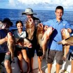
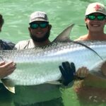
Summer in Venice means one thing to serious anglers: Tarpon. The annual migration is peaking, and massive schools of these prehistoric bruisers are rolling just off the beaches and stacking up in the Venice Inlet. These fish are in their pre-spawn staging phase, gorging on crustaceans and baitfish before heading offshore to broadcast their eggs. While they are highly active, they are also heavily pressured by the local fleet, requiring stealthy approaches, perfectly tied knots, and flawless bait presentations to secure a hookup.
Sleeper Pick: Mangrove Snapper
While the majority of the fleet is busy chasing tarpon and offshore pelagics, the nearshore Mangrove Snapper bite is quietly going off. These structure-loving fish have moved onto the nearshore artificial reefs, limestone ledges, and rock piles in 20 to 40 feet of water. Often overlooked by trophy hunters, they provide phenomenal light-tackle action, aggressive strikes, and are arguably the best-eating fish you can target within a short run from the beach.
Baitfish Report
The coastal waters are currently flushed with massive amounts of forage. Matching your presentations to the primary forage types is the key to a successful outing. The current menu includes:
Threadfin Herring & Pilchards: Dense schools are holding over the nearshore hard bottom, along the beaches, and around the inlet markers.
Pass Crabs: Strong outgoing tides are flushing these crustaceans from Roberts Bay and Dona Bay into the Gulf of Mexico, creating a natural, high-protein chum line.
Pinfish: Abundant on the deeper grass flats and around bridge pilings, serving as excellent bottom baits for larger predators.
TACTICAL STRATEGY
Where to Deploy
To capitalize on the morning bite, position your vessel near the Venice Inlet, specifically favoring the South Jetty on an outgoing tide. The deeper, scoured troughs running parallel to the submerged rocks are major travel corridors for migrating tarpon. Use a GPS spot-lock trolling motor to hold your position just outside the main channel traffic. As the sun rises and the inlet bite inevitably slows, transition to the nearshore structures. The Venice 1-Mile Reef and the scattered limestone ledges just south of the inlet in 30 feet of water are holding excellent concentrations of snapper and occasional gag grouper. For backwater anglers looking to avoid the ocean swells, the deep-water docks along the Intracoastal Waterway (ICW) in Roberts Bay are holding quality snook seeking shade and cooler water.
Lure & Bait Selection
For tarpon, live bait is the undisputed king. Freeline a silver-dollar-sized pass crab or a lively threadfin herring on a 6/0 to 8/0 inline circle hook. Use a 6000 to 8000 series spinning reel loaded with 65-pound braided line, paired with a 60 to 80-pound fluorocarbon leader. If you prefer casting artificials, a 1/2-ounce D.O.A. Baitbuster in Pearl White or Silver Mullet, cast across the tide and retrieved with a slow, sweeping motion, is highly effective.
For the nearshore Mangrove Snapper, you must scale down your tackle significantly. Use a 3000 series spinning reel with 15-pound braid and a 1/4-ounce knocker rig paired with a #1 or 1/0 live bait hook. Thread on a small live pilchard or a large live shrimp. The knocker rig keeps the bait pinned directly to the structure where the snapper live.
Color Selection
Water clarity in the Gulf is currently excellent, leaning toward a gin-clear emerald green. In these conditions, you must stick to natural, translucent presentations. Pearl white, clear with silver flake, and natural baitfish patterns will vastly outproduce loud, fluorescent colors right now. If afternoon rains cause runoff that stains the back bays, switch to rootbeer, gold, or chartreuse profiles to increase contrast in the murky water.
Timing & Conditions
The golden window is from first light until approximately 9:30 AM. The falling tide at the Venice Inlet is the absolute best time to float a crab, as the natural flush mimics the exact feeding pattern the tarpon are staging for. Once the sun is high and the water temperature spikes above 85 degrees, the surface bite shuts down, and you must target deeper structure or heavy shade to find feeding fish.
Pro Tip: When targeting Mangrove Snapper on the nearshore reefs, start by deploying a chum bag heavily loaded with menhaden oil and frozen blocks. Snapper are notoriously leader-shy and possess excellent eyesight; drop down to a 20-pound fluorocarbon leader and bury the hook entirely inside the bait to fool the larger, wiser fish.
Pro Tip: If the tarpon are rolling at the surface but refusing live baits at the inlet, drop a live pinfish down to the bottom on a fish-finder rig. Often, the largest fish in the pod are resting near the sand, letting the smaller, more energetic fish expend energy at the surface.
Pro Tip: When fishing the ICW docks for summer snook, you must skip your baits into the deepest, darkest shade possible. A snook will not leave the thermal refuge of the shadows to chase a bait in the blistering sun. A weedless rigged soft plastic jerkbait is perfect for skipping under low-hanging structures.
REGULATIONS SNAPSHOT
Florida's Gulf Coast regulations are strictly enforced by the FWC, especially during the busy summer months. Always verify your regional boundaries, as Venice falls under the Southwest Management Region for several species.
Species
Season Status
Size Limits
Bag Limits & Notes
Tarpon
Open Year-Round
No minimum size
Catch and Release only. Fish over 40 inches MUST remain in the water at all times.
Snook
Closed (May 1 - Sept 30)
N/A (Catch & Release only)
Zero harvest permitted during summer spawning months. Handle with care and release quickly.
Mangrove Snapper
Open Year-Round
10 inches minimum
5 per harvester per day. Must be landed in whole condition.
Redfish
Open Year-Round
18" to 27" slot limit
1 per harvester per day (Southwest Region).
REGIONAL ALTERNATIVE
If the Gulf is churning from a passing tropical wave, or if the Venice Inlet is simply too congested with boat traffic to fish safely, trailer your skiff 20 minutes south to Lemon Bay. This narrow, highly protected estuary offers miles of pristine mangrove shorelines and lush turtle grass flats that remain fishable even when the wind howls off the Gulf.
Target the eastern shorelines during a morning incoming tide for tailing redfish, working a 1/8-ounce weedless gold spoon through the flooded grass. Alternatively, throw topwater walking baits over the grass flats near Stump Pass at first light for aggressive spotted seatrout. Lemon Bay provides a sheltered, highly productive backup plan that keeps you out of the heavy offshore swells while still delivering top-tier Suncoast angling action. You can easily launch at the Indian Mound Park ramp and be fishing within minutes of leaving the trailer.
Tight lines!
Editor's Choice: Must-Have Gear
FISHINGSIR Next-Gen Waterproof Chest Waders
★★★★★4.4 (7,370+ reviews)
2-Ply Tech: Upgraded nylon with 2.5x higher density than standard fabrics.
100% Waterproof: Lab-approved intrusion resistance with taped visible seams.
Ultra-Lightweight: Designed for all-day comfort while hunting or fishing.
As an Amazon Associate I earn from qualifying purchases. #ad
Loading forecast...
Live Fishing Conditions: Tides, Weather & Waves
Get real‑time tides, marine weather, swell and solunar activity for each spot so you know exactly when conditions line up for your best chance at a bite.
🎣
Venice, Florida
Loading coordinates...
🌤️
WEATHER CONDITIONS
--°F
--°C
Loading...
🌡️
Feels Like--°F--°C
💧
Humidity--%
💨
Wind-- mph-- km/h
🧭
Direction--
📊
Pressure-- inHg-- hPa
☀️
UV Index--
🌊
MARINE CONDITIONS
🌊Wave Height
-- ft
-- m
Loading...
🧭Wave Direction
--°
Loading...
⏱️Wave Period
-- s
Loading...
📈Tide Status
-- ft
-- m
Loading...
🌙
LUNAR & SOLUNAR
🌕
Loading...
Illumination: --%
Major Period--:-- - --:----:-- - --:--
Minor Period--:-- - --:----:-- - --:--
🌅Sunrise--:--
🌇Sunset--:--
📅
24-HOUR FORECAST
Loading fishing conditions...
Fishing Spots Map
🎣
Book a Fishing Charter near Venice, Florida Fishing Report Today 🎣
Local guides & charters. Verified captains, instant booking, best price guaranteed.
There was an error loading the map. Please try refreshing the page.
Info
Local Access & Facilities
Venice, Florida, sits strategically on the Gulf Coast, offering a sophisticated blend of inshore complexity and offshore accessibility that appeals to the serious angler. While often touted casually as the "Shark Tooth Capital of the World," seasoned captains know this area for its high-salinity passes and the productive transition zones between the Intracoastal Waterway (ICW) and the open Gulf. The fishery here is defined by its jetties and the Venice Inlet, which acts as a nutrient superhighway, flushing baitfish in and out with the tides and creating a feeding frenzy for snook, tarpon, and redfish.
The atmosphere in Venice is distinct from the high-pressure tourism hubs of Sarasota to the north or the commercial density of Fort Myers to the south. It retains a "Old Florida" maritime vibe, where the pace is slower but the fishing is intense. The water clarity near the inlet can be exceptional on incoming tides, requiring lighter fluorocarbon leaders and a stealthy approach. Whether you are targeting migratory tarpon rolling off the beaches or bottom-fishing for grouper on the nearshore hard bottom, Venice serves as a calculated departure point for technical Gulf angling.
For the traveling angler or the trailer-boating captain, Venice offers a manageable logistical footprint. The city layout facilitates relatively easy movement between bait shops, ramps, and open water, provided you understand the local traffic rhythms and specific facility limitations. The primary draw here is the ability to launch and clear the pass within minutes, maximizing lines-in-the-water time during the critical dawn and dusk windows.
Access & Getting There
Navigating to the launch points in Venice generally involves the Tamiami Trail (US 41), which serves as the primary artery running north-south through the region. While scenic, this route can suffer from significant congestion during snowbird season and mid-day commercial traffic. For captains trailing heavy center consoles, the approach to the water is mostly paved and wide, but patience is required during peak hours. The primary target for boaters is the Higel Park Boat Ramp, located strategically to offer immediate access to the ICW and a short run to the Venice Inlet.
Higel Park Boat Ramp is the logistical heart of this fishery. The facility includes trailer parking, which is a critical asset in a region where coastal real estate is premium. However, the secret is out; this ramp is heavily utilized by both recreational boaters and local guides. To secure a spot, especially on weekends or during tarpon season, a pre-dawn arrival is not just recommended, it is mandatory. The ramp geometry is generally good, but low tide can expose slick algae on the lower concrete, so 4-wheel drive is advantageous for heavier rigs.
💡 Captain's Tip: Beat the Bridge Traffic
The bridges crossing the Intracoastal can be bottlenecks. If you are trailing a boat from the mainland to the island side during morning rush hour, add 20 minutes to your ETA. Plan to be at the Higel Park ramp before 6:30 AM to avoid the "ramp dance" and secure a trailer slot.
Shore-bound anglers have excellent options near Tarpon Center Drive. This road leads directly to the South Jetty area, a world-class spot for land-based game fishing. Parking here, specifically at the 2000 Tarpon Center Dr Parking lot, is rated highly but fills up rapidly. This location puts you within casting distance of the inlet's channel, where heavy current rips move bait. It is one of the few places where shore anglers can legitimately hook into kingfish, tarpon, and massive snook without stepping foot on a boat.
Weather patterns here are dominated by the Gulf sea breeze. Mornings are typically calm, but the westerly sea breeze kicks in reliably by 11:00 AM or 12:00 PM. When the wind opposes an outgoing tide at the Venice Inlet, the standing waves can become treacherous for smaller skiffs. Always check the tide tables against the wind forecast before committing to an offshore run.
Venice, Florida Pre-Trip Checklist
Facilities & Amenities
The infrastructure in Venice caters well to the independent angler, though it requires knowing exactly where to look. Unlike larger marinas with all-in-one mega-stores, the best services here are specialized and slightly spread out. For bait and tackle, your primary tactical advantage is Fish Tales Bait & Tackle. Located just 1.7 miles from the main fishing grounds in Nokomis, this shop is the local nerve center. They generally open early enough for the dawn patrol and stock the specific live bait needed for the inlet—shrimp and pinfish are staples here.
It is important to note a significant gap in immediate tackle availability if you are launching further south or inland. While Fishin' Franks, inc is a legendary institution with a massive selection and deep local knowledge, it is located nearly 25 miles away in Port Charlotte. Do not plan on "swinging by" Fishin' Franks on your way to a Venice launch unless you are driving up from the south; it is a detour that will cost you an hour of fishing time. Plan your heavy gear purchases in advance or rely on the closer, smaller shops for terminal tackle and bait.
For those seeking guided expertise, the local charter fleet is robust. Angling with Adria Charters, LLC operates directly out of Venice (less than a mile from the center), specializing in the local inshore and nearshore waters. If you are looking for different specialized trips, Sarasota Saltwater Adventures and Hook One Fishing Charters are highly rated options, though they are based roughly 13 miles north in Sarasota. Verify your departure dock with your captain, as some may pick up at Venice locations while others require a drive north.
💡 Captain's Tip: Fuel Logistics
There are limited on-water fuel options directly adjacent to the public ramps. The most efficient strategy is to fuel your vessel at a gas station along US 41 before hitching up or launching. Ethanol-free fuel is available at select stations on the mainland side; fill up the night before to streamline your morning launch.
Lodging for the traveling angler ranges from luxury to rugged. If you are bringing the family and want proximity to the water, Tropical Beach Resorts on Siesta Key is a top-tier option, though it is an 11-mile drive to the Venice launch. For the hardcore angler who prefers solitude and early starts, the Myakka River State Park offers camping facilities, including the Mossy Hammock Primitive Campsite. While this is about 17 miles inland, it places you in a prime position to fish the freshwater upper river or trailer down to the salt early in the morning.
Facility Name
Type
Distance from Center
Key Notes
Fish Tales Bait & Tackle
Bait & Tackle
1.7 miles
Closest reliable shop; essential for live bait.
Higel Park Boat Ramp
Boat Launch
0.7 miles
Primary access; Trailer parking available.
2000 Tarpon Center Dr
Parking
1.2 miles
Prime parking for South Jetty/Shore access.
Angling with Adria Charters
Charter
0.8 miles
Local Venice-based guide service.
Fishin' Franks, inc
Superstore
24.8 miles
Huge selection, but a long drive from Venice.
Permits, Regulations & Fees
Fishing in Venice falls under the jurisdiction of the Florida Fish and Wildlife Conservation Commission (FWC). The state takes resource management seriously, particularly regarding snook and redfish stocks which have fluctuated in recent years due to red tide events. Anglers must possess a valid Florida Saltwater Fishing License for both boat and shore fishing, unless fishing from a licensed pier or charter. These licenses are strictly enforced, and FWC officers frequently patrol the Higel Park ramp and the Venice Inlet jetties.
Special attention must be paid to the "Snook Management Regions." Venice lies on the Gulf coast, where seasons and slot limits often differ from the Atlantic side. The inlet is a harvest point, but it is also a breeding ground; catch-and-release is culturally encouraged by the local guide community even when seasons are open, to preserve the trophy fishery. Additionally, be aware of manatee zones in the ICW. The "No Wake" zones are extensive and strictly monitored to protect these mammals, especially during the cooler months when they congregate in warmer shallow waters.
Parking fees are generally applicable at beach access points, though some boat ramp parking may be included or require a specific recreational permit depending on the municipality's current statutes. Always check the signage at Higel Park immediately upon arrival to avoid citations. The Public Parking Lot on Miami Ave W offers an alternative for those walking to urban fishing spots, but trailer parking there is prohibited.
Events & Seasonal Information
The fishing calendar in Venice is dictated by water temperature and bait migration. The spring and early summer months trigger the renowned tarpon migration. During this time, the passes and beaches off Venice become world-class grounds for the "Silver King." This is tournament season, and the pressure on the water increases significantly. If you are visiting during May or June, expect crowded ramps and competitive etiquette at the inlet.
Winter brings a different rhythm. As water temperatures drop, sheepshead congregate around the pilings and jetty rocks at the Venice Inlet. This is a favorite time for shore anglers and kayak fishermen, as the fish are accessible without a heavy offshore boat. The cooler months also push snook into the backcountry creeks and residential canals, making for excellent stealth fishing in the ICW.
💡 Captain's Tip: Tides Matter
The water movement at the Venice Inlet is the primary feeding trigger. The most productive bite often occurs during the last two hours of the incoming tide and the first hour of the outgoing. Plan your day around the tide chart rather than the clock.
Contact Information & Resources
For emergency situations on the water, the U.S. Coast Guard and local marine patrol units are the first line of defense. Cell reception is generally strong in the inlet and nearshore waters, but can become spotty as you push further offshore. It is advisable to file a float plan with a reliable contact on land, especially if venturing out solo from the Higel Park ramp.
While there is no dedicated Harbor Master office listed for the public ramp itself, local bait shops like Fish Tales often serve as unofficial information hubs for current water conditions and red tide alerts. Always verify the latest environmental reports before launching, as conditions on the Gulf can change rapidly.
For precise locations of the boat ramps, bait shops, and real-time weather conditions, consult the live dashboard and interactive maps below.
Our spot reports combine data-driven forecasts with curated local information. The forecast is generated by our proprietary Fishing Score algorithm (0–100%), which analyzes real-time data from Open-Meteo API, validated against NOAA CO-OPS tide gauges and USGS water-monitoring stations. The model weights tide dynamics (35%), wave energy (25%), wind patterns (20%) and time of day (20%)—factors shown to influence fish feeding behavior through marine-biology research and decades of charter log data.
Access, facilities and services information for each fishing spot is sourced from official datasets such as Recreation.gov (RIDB), state park & wildlife agencies, and geospatial providers like Google Maps. These sections undergo scheduled re-validation every 3–6 months to ensure that boat ramps, park access, contact details and local services remain accurate.
Narrative sections (catches, seasonal behavior, local tips) are synthesized from these data sources and refined following the Fishing Reports Today editorial guidelines, combining bibliographic research from ichthyology and oceanography with expert angler experience. Our team reviews reports on a regular basis, while the forecast model itself updates every 6 hours for real-time accuracy.
⚠️ Important: Always verify current local regulations, access restrictions and weather conditions before fishing. These reports are intended as a planning aid, not a guarantee of catches or safety. When in doubt, contact local authorities or park managers listed on the page.
To provide the best experiences, we use technologies like cookies to store and/or access device information. Consenting to these technologies will allow us to process data such as browsing behavior or unique IDs on this site. Not consenting or withdrawing consent, may adversely affect certain features and functions.
Functional Always active
The technical storage or access is strictly necessary for the legitimate purpose of enabling the use of a specific service explicitly requested by the subscriber or user, or for the sole purpose of carrying out the transmission of a communication over an electronic communications network.
Preferences
The technical storage or access is necessary for the legitimate purpose of storing preferences that are not requested by the subscriber or user.
Statistics
The technical storage or access that is used exclusively for statistical purposes.The technical storage or access that is used exclusively for anonymous statistical purposes. Without a subpoena, voluntary compliance on the part of your Internet Service Provider, or additional records from a third party, information stored or retrieved for this purpose alone cannot usually be used to identify you.
Marketing & Affiliates
The technical storage or access is required to create user profiles to send advertising, or to track the user on a website or across several websites for similar marketing purposes, including affiliate tracking for products recommended in our reports.


Leave a Reply