Welcome to the latest insider fishing report for Cortez, Florida. Situated perfectly between the expansive flats of Anna Maria Sound and the fertile waters of Sarasota Bay, this historic fishing village is currently offering world-class angling opportunities. As the Gulf waters transition into their late-spring patterns, the estuaries are flooded with bait, and predator species are feeding aggressively.
GO/NO-GO STATUS
Verdict: GO
Current seasonal conditions across the Suncoast are absolutely prime for anglers looking to capitalize on the warming inshore waters. We are seeing stable, consistent warming trends pushing Gulf and bay water temperatures into the highly desirable mid-to-upper 70s. This temperature threshold is the magic number that fires up the inshore bite and triggers massive movements of baitfish from the deeper Gulf into the shallow estuaries.
From the editor
Tired of fishing with strangers you can’t trust?
Nautrek is the first social network for serious anglers — verified partners, real trips, cost splitting and intel sharing without burning your spots. Private beta now open.
Weather Impact & Safety Advisory: Barometric pressure is holding steady, and incoming tides are bringing crystal-clear, oxygen-rich water through Longboat Pass and Anna Maria Sound. Wind conditions are generally favorable for both flats fishing and nearshore pursuits, though anglers should maintain a vigilant watch for predictable afternoon sea breezes that can chop up the open bays. Navigate the shallow grass flats with caution during negative low tides to protect the seagrass and your lower unit.
SPECIES INTEL
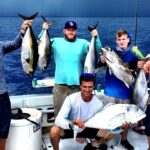
Based on local ground-truth observations and current biological activity, the local estuaries are teeming with life. Here is exactly what is swimming in Cortez waters right now.
Primary Target: Snook (Linesiders)
Snook are highly active and transitioning from their winter back-country haunts toward the passes and beaches in preparation for their summer spawn. They are feeding voraciously on the incoming bait schools, making them the premier target for inshore anglers looking for explosive strikes and drag-screaming runs.
Sleeper Pick: Tripletail
Often overlooked by flats anglers focused on the inshore slam, Tripletail are currently holding on stone crab trap buoys and channel markers just outside the passes and along the deeper edges of Tampa Bay. These prehistoric-looking fish offer incredible sight-casting opportunities and are arguably the best table fare in the region.
Baitfish Report
The forage base is exploding right now. We are seeing massive pushes of Scaled Sardines (whitebait) and Atlantic Thread Herring (greenbacks) moving into the shallows. Recent data also shows a strong presence of Striped Anchovies and Pinfish moving through the passes. Predators are completely dialed into these dense bait schools.
Pro Tip: Match the hatch by throwing silver, white, or translucent olive profiles. When throwing cast nets for live bait, chum the grass flats in 3 to 5 feet of water on an incoming tide using a mixture of tropical fish food and menhaden oil.
TACTICAL STRATEGY
To maximize your time on the water, precision is key. Here is the tactical breakdown for current conditions.
Where to Find Them
For Snook, target the 8-to-12-foot troughs along Longboat Pass and the heavy shade lines under the historic Cortez fishing village docks. Look for current seams where water is being funneled around concrete pilings or mangrove points. For Spotted Seatrout, work the 4-to-6-foot mottled grass flats on the eastern edge of Anna Maria Sound, specifically the drop-offs north of the Cortez Bridge.
Lure Selection & Color
If you are throwing artificials, a 3/8-ounce chartreuse jig head paired with a 4-inch paddle tail swim bait in Pearl or Bad Shad is highly effective. For working the shallow potholes, a slow-sinking twitch bait in a silver-and-green-back pattern perfectly mimics the local whitebait.
Bait & Rigging
Live bait is king right now. Free-line a live Scaled Sardine hooked lightly through the nostrils on a 3/0 inline circle hook. Use a 30-pound fluorocarbon leader for Seatrout and Redfish, but upsize to a 40-pound or 50-pound fluorocarbon leader when pitching under the Cortez docks to prevent Snook from breaking you off on the barnacles.
Timing the Bite
Moving water is an absolute necessity. The most productive window is the last two hours of the incoming tide and the first hour of the outgoing tide, preferably aligning with dawn or dusk. This avoids the midday heat, minimizes boat traffic interference, and puts you on the water when apex predators are most aggressive.
Pro Tip: When fishing the mangrove shorelines of Palma Sola Bay, skip your baits deep into the shadows. Snook will often stage as far back into the root systems as possible during high sun periods.
REGULATIONS SNAPSHOT
Florida Fish and Wildlife Conservation Commission (FWC) regulations are strictly enforced in the Sarasota Bay and Tampa Bay management zones. Always verify current rules before harvesting, as regional management approaches are actively updated.
Species
Season Status
Size Limits
Bag Limits (Per Harvester)
Snook
CLOSED (Catch & Release Only)
28 - 33 inches (When Open)
0 (Harvest prohibited May 1 - Aug 31)
Redfish (Red Drum)
OPEN
18 - 27 inches
1 fish (2 fish vessel limit)
Spotted Seatrout
OPEN
15 - 19 inches
3 fish (1 over 19 inches per vessel)
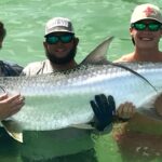
Tarpon
OPEN (Catch & Release Only)
N/A
0 (Do not remove fish over 40 inches from water)
REGIONAL ALTERNATIVE
If strong afternoon sea breezes or passing cold fronts chop up Anna Maria Sound and make the open flats unfishable, head inland to the protected waters of the Manatee River in nearby Bradenton.
The Backup Plan: Manatee River Backcountry
Access: Launch at the Warners Bayou Boat Ramp, which provides immediate access to sheltered coves and residential canals.
Target Species: Juvenile Tarpon, Redfish, and resident Snook.
Tactical Approach: The river's winding bends and high mangrove shorelines offer excellent wind protection. Target the deep outside bends of the river and residential docks using weedless soft plastic jerkbaits or live select shrimp fished under a popping cork. The darker, tannin-stained water of the river requires darker lure colors; switch to rootbeer, gold, or new penny color profiles to maximize contrast and draw strikes.
Tight lines!
Editor's Choice: Must-Have Gear
FISHINGSIR Next-Gen Waterproof Chest Waders
★★★★★4.4 (7,370+ reviews)
2-Ply Tech: Upgraded nylon with 2.5x higher density than standard fabrics.
100% Waterproof: Lab-approved intrusion resistance with taped visible seams.
Ultra-Lightweight: Designed for all-day comfort while hunting or fishing.
As an Amazon Associate I earn from qualifying purchases. #ad
Loading forecast...
Live Fishing Conditions: Tides, Weather & Waves
Get real‑time tides, marine weather, swell and solunar activity for each spot so you know exactly when conditions line up for your best chance at a bite.
🎣
Cortez Florida
Loading coordinates...
🌤️
WEATHER CONDITIONS
--°F
--°C
Loading...
🌡️
Feels Like--°F--°C
💧
Humidity--%
💨
Wind-- mph-- km/h
🧭
Direction--
📊
Pressure-- inHg-- hPa
☀️
UV Index--
🌊
MARINE CONDITIONS
🌊Wave Height
-- ft
-- m
Loading...
🧭Wave Direction
--°
Loading...
⏱️Wave Period
-- s
Loading...
📈Tide Status
-- ft
-- m
Loading...
🌙
LUNAR & SOLUNAR
🌕
Loading...
Illumination: --%
Major Period--:-- - --:----:-- - --:--
Minor Period--:-- - --:----:-- - --:--
🌅Sunrise--:--
🌇Sunset--:--
📅
24-HOUR FORECAST
Loading fishing conditions...
Fishing Spots Map
🎣
Book a Fishing Charter near Cortez Florida Fishing Report Today 🎣
Local guides & charters. Verified captains, instant booking, best price guaranteed.
There was an error loading the map. Please try refreshing the page.
Info
Local Access & Facilities
Old Florida Charm at the Mouth of Tampa Bay
Situated on the northern edge of Sarasota Bay and guarding the southern entrance to Tampa Bay, Cortez stands as one of the last remaining commercial fishing villages in Florida. Unlike the manicured resort coasts to the south or the industrial ports to the north, this location offers seasoned anglers a glimpse into the state's maritime soul. The atmosphere here is defined by working trawlers, historic net camps, and a deep-rooted respect for the harvest of the sea. For the expert angler, this is not merely a tourist stop; it is a strategic launchpad providing immediate access to some of the most productive inshore grass flats and nearshore Gulf ledges in the region.
The primary draw for captains visiting this sector is the diversity of water. To the east, the sheltered waters of Anna Maria Sound and the Manatee River offer refuge during heavy trade winds, holding populations of Snook, Redfish, and Spotted Seatrout. To the west, the deep passes leading into the Gulf of Mexico—specifically around Egmont Key—serve as highways for migratory Pelagics, Tarpon, and Kingfish. The bottom topography varies drastically from the shallow, seagrass-laden flats of the sound to the shifting sandbars and deep shipping channels that scour the mouth of the bay.
While the village itself retains a rugged, historic vibe, the surrounding waters require technical precision to navigate. The convergence of the Manatee River outflow with the Gulf tides creates strong currents and shifting shoals, particularly around the barrier islands. Anglers targeting this area are stepping into a fishery where history and biology collide, offering opportunities to fish the same grounds that have supported commercial fleets for over a century.
Access & Getting There
Reaching Cortez typically involves navigating the busy corridors of Manatee County. The primary artery is Cortez Road (State Road 684), which runs directly west from Bradenton. Traffic on this route can be deceptively heavy, particularly on weekends and holidays when beachgoers flock to Anna Maria Island. Experienced skippers know that the bridge crossing into the village and out to the island is a notorious bottleneck. To maximize fishing time, trailering crews should aim to clear the mainland intersections well before 7:00 AM. During the winter season, congestion can add upwards of 45 minutes to a seemingly short drive.
For boat owners, launch options in the immediate vicinity require strategic planning. The data indicates boat ramp facilities near latitude 27.49 and 27.45. While some of these are municipal ramps, they are often subject to high demand. The ramps in this region can be steep and slick at low tide; four-wheel drive is recommended for heavier center consoles. A critical logistical note for those seeking access to the remote Egmont Key National Wildlife Refuge: this location is accessible strictly by watercraft. There are no bridges connecting it to the mainland. Captains launching from Cortez or Bradenton should prepare for a run of approximately 10 to 12 miles across open water to reach the key.
💡 Captain's Tip: Navigating the Pass
When running from Cortez to Egmont Key, pay close attention to the weather. The open expanse of Tampa Bay can whip up a steep, confused chop when an outgoing tide meets a strong sea breeze. If the winds are bucking the tide, consider staying inside the barrier islands until you reach the pass to minimize the beating on your hull.
Weather plays a significant role in accessibility here. The region is exposed to the Gulf of Mexico weather systems. During the summer months, afternoon thunderstorms build rapidly over the mainland and push offshore, potentially cutting off the return route for boaters near Passage Key or Egmont Key. In the winter, cold fronts clocking around from the north can drain the bays, resulting in extremely low tides that make some ramps and channels impassable for deep-draft vessels. Always verify tide charts specifically for Cortez and Anna Maria Sound, as they can differ significantly from the St. Petersburg tide stations.
Parking for trailers is a premium commodity in this historic district. While the 12th Street Garage in Sarasota is listed in regional data, it is over 11 miles away and not suitable for boat trailers. Anglers should utilize the dedicated lots at local boat ramps or the Public Beach Access on Longboat Key (7.2 miles away) for surf casting excursions. Security is generally good, but the high volume of tourist traffic means that leaving gear visible in truck beds is ill-advised. Ensure your vehicle is parked within designated lines, as local enforcement is strict regarding trailer encroachment on rights-of-way.
Cortez Florida Pre-Trip Checklist
Facilities & Amenities
The infrastructure around Cortez caters to a mix of commercial operations and recreational angling, though there are notable gaps that visiting anglers must anticipate. Unlike large recreational marinas that feature every amenity on a single dock, the services here are decentralized. For those seeking guided expertise, the local fleet is robust. Fishing With Salty operates out of Bradenton, a mere 3.3 miles from the heart of the fishery, and is well-regarded for inshore knowledge. For those staying on the islands, AMI Excursions is located 6.5 miles away in Anna Maria and offers specialized local charters. These operators are accustomed to the seasonal nuances of the bay and are excellent resources for real-time reports.
A critical piece of "negative knowledge" for the self-sufficient angler involves bait and tackle acquisition. The primary data indicates that major outfitters like TBFC Bait and Tackle (Ruskin), 4th Street Tackle, and Gulf Coast Bait and Tackle (St. Petersburg) are located between 20 and 24 miles away. This implies that Cortez itself lacks a large-scale, big-box marine retailer. Anglers trailing boats from the north or inland should stock up on terminal tackle, frozen bait, and specialized lures before crossing the Skyway Bridge or hitting the final stretch of Cortez Road. Do not rely on finding heavy offshore gear or specific electronics parts in the immediate village early in the morning.
💡 Captain's Tip: Bait Logistics
Since major tackle shops are a 30-minute drive away, seasoned captains bring their own cast nets to catch bait on the flats near the designated boat ramps. Greenbacks and pinfish are usually abundant on the grass flats of Anna Maria Sound, saving you a long drive back to St. Pete.
For lodging, the options range from historic grandeur to functional proximity. The iconic The Don CeSar, known as the "Pink Palace," is located 17.3 miles north on St. Pete Beach. While it offers luxury and a deep history dating back to 1928, it is a significant drive from the Cortez boat ramps for a dawn patrol launch. A closer high-end option is The Resort at Longboat Key Club, roughly 10.4 miles south. For anglers prioritizing proximity over luxury, look for smaller rentals or motels in Bradenton Beach or Anna Maria, which reduce the morning commute to the ramp significantly.
Facility Name
Type
Distance
Notes
Fishing With Salty
Charter
3.3 miles
Close proximity; local inshore expertise.
AMI Excursions
Charter
6.5 miles
Located on Anna Maria Island; open early.
The Resort at Longboat Key Club
Lodging
10.4 miles
Upscale resort with marina access nearby.
TBFC Bait and Tackle
Shop
20.8 miles
Major outfitter; requires driving to Ruskin.
The Don CeSar
Lodging
17.3 miles
Historic luxury; further drive from Cortez ramps.
Permits, Regulations & Fees
Navigating the regulatory landscape in this area is as important as navigating the channels. The waters surrounding Cortez interact with several federal and state protected zones. Most notably, the Egmont Key National Wildlife Refuge is a critical area. While the island is a popular destination, roughly one-third of the key—specifically the southern end—is designated as a bird sanctuary. These areas are strictly off-limits to foot traffic to protect nesting shorebirds like black skimmers and royal terns. Anglers may fish from boats in the surrounding waters, but landing on the protected southern beaches is a violation of federal law.
Even more restrictive is the Passage Key National Wildlife Refuge, located just south of Egmont Key. This low-lying sandbar, which often disappears at high tide, is a designated wilderness area. It is closed to all public use year-round. There is no landing, hiking, or walking allowed on Passage Key. This is strictly enforced to protect nesting colonies. Captains should be vigilant when drifting near these shoals; while the fishing for Tarpon and Permit on the drop-offs near the refuge is excellent, putting a hull on the sand here can result in significant federal fines.
Cultural heritage sites also demand respect. The De Soto National Memorial, located about 3.8 miles from the spot, marks the potential landing site of Conquistador Hernando de Soto in 1539. While fishing is a recognized activity within the park (likely wading or shoreline fishing), visitors must respect the grounds and the "Kapu" (sacred/forbidden) nature of specific historical markers. Additionally, the presence of the Parker Manatee Aquarium nearby signals that these waters are prime manatee habitats. "Slow Speed" and "No Wake" zones are aggressively enforced by the Florida Fish and Wildlife Conservation Commission (FWC), particularly in the Intracoastal Waterway and near seagrass beds.
Events & Seasonal Information
The fishing calendar in Cortez is dictated by the rhythm of the Gulf. The most significant seasonal event is the massive Tarpon migration that occurs in late spring and early summer. The passes between Anna Maria Island and Egmont Key become world-class arenas for giant Silver Kings. During this "hill tide" season, crab flushes on outgoing tides attract thousands of gamefish. Consequently, boat traffic increases exponentially, and launch ramps will reach capacity before sunrise. Professional captains know to time their movements to avoid the midday crush of recreational boaters chasing the pods.
Winter brings a different cadence. As water temperatures drop, Sheepshead and Black Drum congregate around the pilings of the local bridges and the deeper docks of the village. The Cortez Commercial Fishing Festival, typically held in February, is a major cultural event that celebrates the village's heritage. While it draws large crowds and can complicate traffic on Cortez Road, it is an excellent time to connect with local commercial skippers and gain intel on offshore conditions. During these cooler months, the negative low tides can trap unwary boaters on the flats of Sarasota Bay; checking the tide tables for the specific "Cortez" station is mandatory.
💡 Captain's Tip: Summer Storms
In the summer months (June–September), the sea breeze front often collides with the coast around 2:00 PM. This generates violent, electrical storms. Plan your offshore runs to be heading back toward the pass by 1:00 PM to avoid getting cut off by a wall of lightning.
Contact Information & Resources
For definitive information on access and current conditions, direct communication with managing agencies is recommended. The Egmont Key and Passage Key National Wildlife Refuges are managed by the U.S. Fish and Wildlife Service, reachable at 352-563-2088. For inquiries regarding the De Soto National Memorial, including shore access hours, contact the National Park Service at (941) 792-0458. The The Don CeSar can be reached at 800-678-8946 for lodging inquiries, though anglers should confirm trailer parking policies in advance.
Safety in this region is largely a matter of self-reliance, especially when venturing past the barrier islands. Cell signal can be spotty offshore near the Egmont channel. Always file a float plan. In the event of an emergency on the water, the Coast Guard Sector St. Petersburg monitors VHF Channel 16. Ensure your vessel is equipped with required safety gear, as FWC patrols are frequent and thorough in these high-traffic passes.
For precise locations of the boat ramps, real-time wind conditions, and interactive charts of the restricted zones mentioned above, consult the live dashboard and maps below.
Our spot reports combine data-driven forecasts with curated local information. The forecast is generated by our proprietary Fishing Score algorithm (0–100%), which analyzes real-time data from Open-Meteo API, validated against NOAA CO-OPS tide gauges and USGS water-monitoring stations. The model weights tide dynamics (35%), wave energy (25%), wind patterns (20%) and time of day (20%)—factors shown to influence fish feeding behavior through marine-biology research and decades of charter log data.
Access, facilities and services information for each fishing spot is sourced from official datasets such as Recreation.gov (RIDB), state park & wildlife agencies, and geospatial providers like Google Maps. These sections undergo scheduled re-validation every 3–6 months to ensure that boat ramps, park access, contact details and local services remain accurate.
Narrative sections (catches, seasonal behavior, local tips) are synthesized from these data sources and refined following the Fishing Reports Today editorial guidelines, combining bibliographic research from ichthyology and oceanography with expert angler experience. Our team reviews reports on a regular basis, while the forecast model itself updates every 6 hours for real-time accuracy.
⚠️ Important: Always verify current local regulations, access restrictions and weather conditions before fishing. These reports are intended as a planning aid, not a guarantee of catches or safety. When in doubt, contact local authorities or park managers listed on the page.
To provide the best experiences, we use technologies like cookies to store and/or access device information. Consenting to these technologies will allow us to process data such as browsing behavior or unique IDs on this site. Not consenting or withdrawing consent, may adversely affect certain features and functions.
Functional Always active
The technical storage or access is strictly necessary for the legitimate purpose of enabling the use of a specific service explicitly requested by the subscriber or user, or for the sole purpose of carrying out the transmission of a communication over an electronic communications network.
Preferences
The technical storage or access is necessary for the legitimate purpose of storing preferences that are not requested by the subscriber or user.
Statistics
The technical storage or access that is used exclusively for statistical purposes.The technical storage or access that is used exclusively for anonymous statistical purposes. Without a subpoena, voluntary compliance on the part of your Internet Service Provider, or additional records from a third party, information stored or retrieved for this purpose alone cannot usually be used to identify you.
Marketing & Affiliates
The technical storage or access is required to create user profiles to send advertising, or to track the user on a website or across several websites for similar marketing purposes, including affiliate tracking for products recommended in our reports.


Leave a Reply