The late spring transition is in full swing across the St. Marks and Apalachee Bay region, making this an exceptional time to hit the water. Warming water temperatures have triggered a massive influx of baitfish into the shallows, bringing apex predators right behind them. Weather conditions are highly favorable with mild breezes and stable barometric pressure, creating ideal sight-fishing opportunities on the clear flats. However, anglers should note that we are currently experiencing a period of lower tidal coefficients. This means there is significantly less water movement between high and low tides compared to a full or new moon phase. To succeed in these conditions, you will need to focus your efforts on key pinch points, oyster bars, and channel edges where the reduced current is naturally funneled and accelerated to find actively feeding fish.
Safety Advisory: Coastal waters are running clear and warming rapidly, but always monitor the afternoon sea breeze, which can kick up a sudden, steep chop on the open flats of Apalachee Bay. Furthermore, navigate the treacherous limestone rock bars near the St. Marks Lighthouse with extreme caution, particularly during the bottom of the falling tide when submerged hazards are just below the surface. If you are unsure of the channel markers, idle your outboard.
From the editor
Tired of fishing with strangers you can’t trust?
Nautrek is the first social network for serious anglers — verified partners, real trips, cost splitting and intel sharing without burning your spots. Private beta now open.
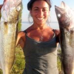
Based on recent verified biological data and local catch reports, Spotted Seatrout and Flounder (both Gulf and Southern species) are dominating the nearshore coastal catches around the Crawfordville and St. Marks coastal zones. The Seatrout are holding in the sandy potholes, while the Flounder are staging along the drop-offs. In the brackish estuaries and freshwater tributaries, Florida Bass and Redear Sunfish (locally known as Shellcrackers) are pushing aggressively into shallow spawning grounds. Verified catch data even highlights Bluegill and Redear hybrids in the local ponds, providing fantastic light-tackle action.
Sleeper Pick
Black Crappie and Pigfish. While most coastal anglers are entirely focused on the inshore saltwater glamour species, the deep river bends and inland lakes are producing excellent crappie slabs right now. Meanwhile, Pigfish are showing up in solid numbers near Alligator Point. Not only do Pigfish provide excellent light-tackle action for young anglers, but they are also the absolute best live bait you can pitch for trophy-sized Seatrout and roaming predators.
Baitfish Report
The shallows are absolutely flooded with forage right now, and understanding this food web is critical to your success. Biological ground truth data confirms massive, concentrated schools of baitfish in the area. Key forage species include:
Eastern Mosquitofish & Sailfin Mollies: Swarming in the marsh creeks and tidal runouts.
Gulf Killifish (Mud Minnows): Holding tight to the muddy bottom and oyster shell edges.
Juvenile Pinfish & Inland Silversides: Schooling heavily over the open turtle grass flats.
If you are not matching these specific baitfish profiles in size, shape, and color, you are leaving fish on the table.
Tactical Strategy
Where to Look
For premier saltwater action, focus your efforts on the grass flats and rock weedlines directly south and east of the St. Marks Lighthouse. Work the 3 to 6
foot depth range where sandy potholes break up the dense turtle grass. For Flounder, shift your focus to the deeper creek mouths, oyster bar points, and the sharp drop-offs along the main St. Marks River channel where receding water sweeps bait off the shallow flats. Freshwater anglers chasing Florida Bass and Shellcrackers should target the shallow, lily-pad-lined margins of the Wakulla River and local Crawfordville lakes, paying special attention to areas with hard, sandy bottoms that provide ideal spawning habitat.
What to Throw
Saltwater: To match the abundant Inland Silversides and juvenile Pinfish, tie on a 3-to-4-inch soft plastic paddletail in pearl white, rootbeer, or natural baitfish patterns rigged on a 1/8 to 1/4-ounce jighead. Suspending twitchbaits are also highly effective right now for drawing aggressive strikes from Spotted Seatrout holding over the grass. If you prefer live bait, freelining a live Pigfish or suspending a Mud Minnow under a popping cork is a nearly guaranteed method for targeting larger, trophy-class predators.
Freshwater: For the staging Florida Bass, weightless weedless flukes and wacky-rigged stick worms pitched into the shoreline vegetation are producing consistent bites. To target the Shellcrackers and Crappie, small beetle spins, 1/16-ounce marabou jigs in chartreuse or white, or a simple live red wiggler under a float will keep your rod bending all day.
Technique
Because of the lower tidal coefficients mentioned earlier, finding water movement is your most valuable asset. Time your fishing around the precise hours of the incoming or outgoing tide, no matter how slight the flow. When targeting Flounder on the drop-offs, ensure your bait is maintaining constant contact with the bottom; a slow, steady drag with occasional pauses will out-produce a fast retrieve. For the Seatrout, a vigorous pop of the cork followed by a long, five-second pause allows the bait to settle naturally into the strike zone where ambush predators are waiting.
Solunar & Environmental Outlook
With stable barometric pressure in place, the early morning topwater bite is prime before the sun gets too high and pushes the fish into slightly deeper, cooler water. Peak feeding windows will align tightly with the major and minor solunar periods, specifically during the brief windows of maximum tidal flow. Keep an eye on the water clarity; if the afternoon sea breeze churns up the flats, switch to darker colored lures or baits with internal rattles to help the fish locate your presentation through vibration and contrast rather than sight.
Tight lines!
Editor's Choice: Must-Have Gear
FISHINGSIR Next-Gen Waterproof Chest Waders
★★★★★4.4 (7,370+ reviews)
2-Ply Tech: Upgraded nylon with 2.5x higher density than standard fabrics.
100% Waterproof: Lab-approved intrusion resistance with taped visible seams.
Ultra-Lightweight: Designed for all-day comfort while hunting or fishing.
As an Amazon Associate I earn from qualifying purchases. #ad
Loading forecast...
Live Fishing Conditions: Tides, Weather & Waves
Get real‑time tides, marine weather, swell and solunar activity for each spot so you know exactly when conditions line up for your best chance at a bite.
🎣
St. Marks
Loading coordinates...
🌤️
WEATHER CONDITIONS
--°F
--°C
Loading...
🌡️
Feels Like--°F--°C
💧
Humidity--%
💨
Wind-- mph-- km/h
🧭
Direction--
📊
Pressure-- inHg-- hPa
☀️
UV Index--
🌊
MARINE CONDITIONS
🌊Wave Height
-- ft
-- m
Loading...
🧭Wave Direction
--°
Loading...
⏱️Wave Period
-- s
Loading...
📈Tide Status
-- ft
-- m
Loading...
🌙
LUNAR & SOLUNAR
🌕
Loading...
Illumination: --%
Major Period--:-- - --:----:-- - --:--
Minor Period--:-- - --:----:-- - --:--
🌅Sunrise--:--
🌇Sunset--:--
📅
24-HOUR FORECAST
Loading fishing conditions...
Fishing Spots Map
🎣
Book a Fishing Charter near St. Marks Fishing Report Today 🎣
Local guides & charters. Verified captains, instant booking, best price guaranteed.
There was an error loading the map. Please try refreshing the page.
Info
Local Access & Facilities
St. Marks represents a quintessential slice of "Old Florida," offering a rugged, historically rich fishery that stands in stark contrast to the manicured marinas found further south. Situated at the confluence of the St. Marks River and the vast Apalachee Bay, this location is defined by its extensive salt marshes, tidal creeks, and the iconic St. Marks National Wildlife Refuge. For the serious angler, the draw here is the pristine quality of the water and the complex bottom topography created by the limestone shelf of the Gulf Coast. The atmosphere is quiet and wild, dominated by the calls of migratory birds rather than the hum of highway traffic.
The fishery is anchored by the historic St. Marks Lighthouse, which has stood sentinel over these waters since 1842. The surrounding estuarine system serves as a nursery for a massive variety of inshore game fish, while the deeper channels offer access to open Gulf species. This is not a location for casual, spur-of-the-moment trips; the wilderness designation implies a level of self-reliance and preparation that seasoned captains respect. The lack of high-rise developments ensures that the horizon remains unbroken, but it also means amenities are specific and spread out.
Anglers targeting this area are typically pursuing species that thrive in the transition zones between freshwater output and the high salinity of the Gulf. The extensive seagrass beds and oyster bars require technical poling or careful navigation. Whether you are launching a technical skiff to stalk the flats or heading out for a day of nearshore bottom fishing, St. Marks offers a solitude that is becoming increasingly rare in Florida waters.
Access & Getting There
Reaching the primary launch zones in St. Marks generally involves a drive south from Tallahassee. The most direct route for those towing vessels is State Road 363 (Woodville Highway) south to Wakulla. From there, the route connects to State Road 267 (Bloxham Cutoff) before hitting US 98 (Coastal Highway). The final leg involves crossing the St. Marks River and turning onto Lighthouse Road (County Road 59). This road dead-ends at the Gulf, providing a scenic but slow drive through the heart of the refuge. Traffic on Woodville Highway can be heavy during weekday commuter hours, so early departures are recommended.
💡 Captain's Tip: Trailer Logistics
The drive down Lighthouse Road is scenic but narrow in sections. Ensure your trailer lights and bearings are in top condition, as there are few places to pull over for repairs once you enter the Refuge. The speed limits are strictly enforced to protect wildlife.
The primary boat access is located within the St. Marks National Wildlife Refuge. The ramps here provide direct access to Apalachee Bay. While the ramps are generally well-maintained, the surrounding infrastructure is minimal. Parking is available for trailers, but during peak migration seasons or weekends with favorable tides, the lots can fill rapidly. The launch areas are exposed to weather; strong winds from the south or southwest can make loading and unloading challenging due to the chop building up across the open bay.
For those accessing the water from the town of St. Marks itself, rather than the Refuge end, the navigation downriver requires attention to channel markers. The river winds significantly before dumping into the bay. Anglers should be aware that the area is tidal, and extreme low tides can expose mudflats that extend far from the marsh grass lines. Always consult a tide chart specific to the St. Marks River entrance, as the lag from the open Gulf can be significant.
St. Marks Pre-Trip Checklist
Facilities & Amenities
Infrastructure in St. Marks is purpose-built for the outdoorsman but is geographically dispersed. Unlike centralized marinas where fuel, ice, and bait are all on one dock, you will likely need to make stops before reaching the launch. RMS Marine Supply (formerly Angie's Marine Supply) in Crawfordville, located about 11.4 miles away, is a critical stop for seasoned skippers. They are known for stocking specialized heavy tackle and marine supplies that the average gas station does not carry. If you require live bait or specific terminal tackle, it is highly advisable to secure it here or at North Florida Sporting Goods (22.4 miles away) before committing to the final drive down Lighthouse Road.
The local charter fleet is concentrated along Riverside Drive and Port Leon Drive. This area serves as the hub for professional guidance. Operators like St Marks Outfitters and Viking Coastal Charters are based within a few hundred feet of the water. Their proximity to the river suggests that if you are looking for up-to-the-minute intelligence on water clarity or bite patterns, this is the neighborhood to visit. The table below details the primary service providers in the immediate vicinity.
Business Name
Type
Distance from Spot
Specialty/Notes
St Marks Outfitters
Charter
350 ft
Local inshore specialists; open daily 9 AM - 5 PM.
Viking Coastal Charters
Charter
0.5 miles
24-hour operation listed; convenient for pre-dawn coordination.
Lost Creek Charters
Charter
0.5 miles
Located on Riverside Dr; highly rated local guides.
RMS Marine Supply
Supply Shop
11.4 miles
Critical stop for heavy tackle; closed Sundays.
💡 Captain's Tip: Fuel Management
There is no fuel dock at the Refuge boat ramp. Top off your tanks in Crawfordville or Wakulla before turning onto Lighthouse Road. Running out of fuel in the marsh creeks can result in a long wait for a tow.
Lodging options in the immediate vicinity of the launch are sparse. Most accommodations are geared towards camping or are located 10 to 20 miles inland. Pinhook River Campsite offers a rustic experience about 11 miles out, while the Econfina Resort (19.2 miles away) provides a more structured stay. For anglers planning a multi-day trip, booking accommodations in advance is crucial, as the limited inventory fills up quickly during peak fishing and hunting seasons.
Permits, Regulations & Fees
Fishing within the St. Marks National Wildlife Refuge requires strict adherence to federal regulations. The Refuge was established in 1931 and encompasses over 86,000 acres, including 17,000 acres designated under the Federal Wilderness Act. This designation often carries restrictions regarding motorized access in specific zones to preserve the primitive character of the landscape. Anglers must respect these boundaries, which are typically marked on Refuge maps. The primary goal here is conservation, so "Leave No Trace" principles are legally enforced.
Access to the Refuge generally requires an entrance fee at the gate on Lighthouse Road. While specific permit prices can fluctuate, visitors should be prepared to pay a daily vehicle fee or present a valid Federal Recreational Lands Pass. Because the Refuge is a sanctuary for migratory birds, certain areas may be closed seasonally to protect nesting habitats. It is the skipper's responsibility to identify these closures, which are often posted at the Visitor Center (located 3 miles down Lighthouse Road).
State fishing regulations are managed by the Florida Fish and Wildlife Conservation Commission (FWC). However, because you are launching from federal land, enforcement can be conducted by both state officers and federal wildlife officers. Pay close attention to size and bag limits, particularly for Redfish and Sea Trout, as these populations are carefully monitored in the Apalachee Bay region. Culturally, this area has a deep history of subsistence and sport fishing; respecting other boats by maintaining a wide berth on the flats is considered mandatory etiquette.
Events & Seasonal Information
The biological rhythms of St. Marks are dictated by migration. October is a particularly notable month, not just for the cooling water temperatures that fire up the inshore bite, but for the arrival of thousands of Monarch butterflies stopping to feed before crossing the Gulf. For the angler, this signals the transition to fall fishing patterns where baitfish begin to exit the marshes, triggering aggressive feeding from predators.
Winter fishing here is distinct. The shallow nature of the bay means water temperatures can drop rapidly with the passage of cold fronts. During these times, fish often move into the deeper holes of the tidal creeks or the St. Marks River channel itself. Conversely, summer brings the heat and the need for "dawn patrol" tactics. The trade winds and sea breezes typically pick up by mid-morning, making fly fishing or sight casting on the open flats difficult after 10:00 AM.
💡 Captain's Tip: Seasonal Crowds
The Refuge is a global destination for birders, especially in winter. Expect the Lighthouse area and parking lots to be congested with photographers and wildlife viewers. Launching before sunrise avoids the bulk of this non-fishing traffic.
While there are no major high-stakes billfish tournaments centered directly at this specific ramp, the area serves as a quiet training ground for serious anglers. The "event" here is the changing of the seasons—from the arrival of migratory ducks in the winter to the Tarpon rolling in the summer heat. Aligning your trip with these natural cycles is far more critical here than checking a tournament calendar.
Contact Information & Resources
For official information regarding ramp closures, gate hours, and current access fees, the primary point of contact is the St. Marks National Wildlife Refuge administrative office. They can be reached at 850-925-6121 or via email at saintmarks@fws.gov. The Visitor Center is an excellent resource for physical maps and current tide tables.
Safety in this region is paramount due to the remoteness of the marsh systems. Cell phone coverage can be spotty once you are deep in the creeks or offshore. Ensure you have a VHF radio and valid safety gear. In the event of an emergency, local marine patrol and the U.S. Coast Guard monitor standard hailing channels, but response times can be longer than in urban ports.
For precise locations of the boat ramps, detailed facility ratings, and real-time weather conditions, consult the live dashboard and interactive maps below.
Our spot reports combine data-driven forecasts with curated local information. The forecast is generated by our proprietary Fishing Score algorithm (0–100%), which analyzes real-time data from Open-Meteo API, validated against NOAA CO-OPS tide gauges and USGS water-monitoring stations. The model weights tide dynamics (35%), wave energy (25%), wind patterns (20%) and time of day (20%)—factors shown to influence fish feeding behavior through marine-biology research and decades of charter log data.
Access, facilities and services information for each fishing spot is sourced from official datasets such as Recreation.gov (RIDB), state park & wildlife agencies, and geospatial providers like Google Maps. These sections undergo scheduled re-validation every 3–6 months to ensure that boat ramps, park access, contact details and local services remain accurate.
Narrative sections (catches, seasonal behavior, local tips) are synthesized from these data sources and refined following the Fishing Reports Today editorial guidelines, combining bibliographic research from ichthyology and oceanography with expert angler experience. Our team reviews reports on a regular basis, while the forecast model itself updates every 6 hours for real-time accuracy.
⚠️ Important: Always verify current local regulations, access restrictions and weather conditions before fishing. These reports are intended as a planning aid, not a guarantee of catches or safety. When in doubt, contact local authorities or park managers listed on the page.
To provide the best experiences, we use technologies like cookies to store and/or access device information. Consenting to these technologies will allow us to process data such as browsing behavior or unique IDs on this site. Not consenting or withdrawing consent, may adversely affect certain features and functions.
Functional Always active
The technical storage or access is strictly necessary for the legitimate purpose of enabling the use of a specific service explicitly requested by the subscriber or user, or for the sole purpose of carrying out the transmission of a communication over an electronic communications network.
Preferences
The technical storage or access is necessary for the legitimate purpose of storing preferences that are not requested by the subscriber or user.
Statistics
The technical storage or access that is used exclusively for statistical purposes.The technical storage or access that is used exclusively for anonymous statistical purposes. Without a subpoena, voluntary compliance on the part of your Internet Service Provider, or additional records from a third party, information stored or retrieved for this purpose alone cannot usually be used to identify you.
Marketing & Affiliates
The technical storage or access is required to create user profiles to send advertising, or to track the user on a website or across several websites for similar marketing purposes, including affiliate tracking for products recommended in our reports.


Leave a Reply