Current seasonal conditions are absolutely prime for urban angling at Sandy Pond, affectionately known by locals as Grandpa's Pond or the Sandy Urban Fishery. As summer temperatures elevate the surface water heat, the thermal dynamics of this compact three-acre waterbody dictate fish behavior. Warm-water species are highly active and feeding aggressively, while cold-water holdovers are seeking thermal refuge in the deepest basins.
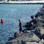
Safety & Weather Advisory: The infrastructure here is excellent. With fully paved banks, a dedicated fishing pier, and manicured walking trails, the location is exceptionally safe and accessible for anglers of all ages and mobility levels. However, during the peak summer season, be prepared for intense midday heat and potential afternoon canyon winds that can ripple the surface and complicate bite detection. Thunderstorms can roll over the Wasatch Front quickly, so maintain situational awareness and be ready to pack up if lightning threatens the valley.
From the editor
Tired of fishing with strangers you can’t trust?
Nautrek is the first social network for serious anglers — verified partners, real trips, cost splitting and intel sharing without burning your spots. Private beta now open.
Pro Tip:Urban fisheries experience heavy recreational traffic from picnickers and dog walkers on weekends. Arrive at first light to secure the best casting lanes, capitalize on the morning bite, and avoid the tangled lines of midday crowds.
SPECIES INTEL
Primary Target
Channel Catfish and Largemouth Bass: During the warmer months, the Utah Division of Wildlife Resources (DWR) shifts its community pond stocking focus toward Channel Catfish. These bottom-dwelling scavengers thrive in the warmer water and provide excellent, rod-bending action for stationary anglers. Concurrently, the resident Largemouth Bass are in their peak metabolic state, aggressively hunting along the shaded margins, submerged root systems, and weed lines.
Sleeper Pick
Bluegill: Often overlooked by anglers swinging for the fences, the panfish population here is robust and highly active. They provide constant, reliable action for young anglers and can be used by savvy veterans to pattern the larger bass that actively feed on them in the shallows.
Baitfish Report
The forage base in this urban ecosystem consists primarily of aquatic insects, terrestrial bugs blown in from the surrounding park, small worms, and juvenile panfish. Pay close attention to the terrestrial insect activity near the Russian Olive trees. During the warmer months, beetles, grasshoppers, and ants frequently fall from the overhanging branches, creating a localized feeding frenzy. Matching the hatch requires downsizing your presentation. Mimicking distressed bluegill or terrestrial insects will yield the highest strike rates.
TACTICAL STRATEGY
Where to Deploy
To maximize your success at Sandy Pond, you must approach the water with a precise, guide-level game plan. Randomly casting into the middle of the lake will rarely yield consistent results. The pond features a maximum depth of approximately twelve feet, with the deepest basin located centrally. Skip the featureless shallow flats on the western edge near the Jordan River.
Instead, focus your efforts toward the southern bank where large Russian Olive trees dominate the landscape. The shade canopy and submerged root systems here create a crucial micro-habitat and prime ambush points for Largemouth Bass and larger Bluegill. If you are targeting holdover Trout or Channel Catfish, set up near the dedicated fishing pier on the eastern edge. Cast toward the center of the pond, working your bait down the drop-off into the eight to twelve-foot zone where cooler water pools and fish congregate.
Gear & Presentation
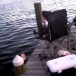
Rod and Reel Setup: For the ultimate urban pond setup, versatility is your greatest asset. A medium-light spinning rod paired with a 2000-size spinning reel provides the perfect balance of finesse and backbone. Spool up with eight-pound braided main line tied to a six-pound fluorocarbon leader.
Lure: For bass, pitch a four-inch wacky-rigged Senko or a 1/8oz tungsten tear drop jig tipped with a small curly tail grub under the overhanging branches. Fly anglers can capitalize on the terrestrial bite by tossing foam hoppers, while spin anglers can use clear casting bubbles to deliver weightless artificial flies. For holdover trout in the deep basin, a Rapala Jigging Rap #5 allows you to precision-bomb the deeper, cooler water.
Color: Water clarity in urban ponds during summer can range from stained to murky due to seasonal algae blooms. Stick to high-contrast colors. Utilize green pumpkin or black-and-blue for soft plastics, and firetiger or chartreuse for hard baits.
Bait: For Channel Catfish, deploy a slip-sinker rig consisting of a 1/2oz egg weight, barrel swivel, eighteen-inch fluorocarbon leader, and a 1/0 circle hook. Load the hook with chicken liver, nightcrawlers, or heavily scented cut bait.
Timing
The low-light windows of dawn and dusk are absolutely critical. The midday sun drives fish deep into a state of lethargy and brings out heavy park crowds. The first two hours of daylight offer the best topwater bite for bass, while the last hour of light triggers the catfish to begin roaming the flats to feed heavily.
Pro Tip:If the bottom of the pond is covered in summer muck or decaying vegetation, swap your slip-sinker rig for a slip-bobber setup. Suspending your chicken liver or nightcrawler just twelve to eighteen inches above the bottom keeps it in the visual strike zone and prevents it from getting lost in the silt.
REGULATIONS SNAPSHOT
Sandy Pond falls under Utah's community pond fishing regulations. Enforcement is strict to maintain the quality of the fishery for all residents. Always verify current DWR proclamations before hitting the water.
Regulation Type
Details
Daily Bag Limit
Two fish total (combined species limit).
Largemouth Bass
Voluntary catch and release is highly encouraged to sustain the predatory population.
Operating Hours
Open to fishing only when the community park is open (Dawn to 10:00 PM).
Watercraft Restrictions
Strictly prohibited. No boats, swimming, or floating devices of any kind are allowed on the lake.
REGIONAL ALTERNATIVE
If Sandy Pond is too crowded with weekend picnickers, or if the bite shuts off due to a sudden weather front, you have excellent backup options within a very short drive. Willow Pond in nearby Murray is a phenomenal alternative located just a few miles north in the Salt Lake Valley.
Willow Pond is a slightly larger community fishery that receives massive, frequent stocking allocations of both Channel Catfish and Rainbow Trout from the DWR. The facility offers similar paved access, fishing piers, and excellent shorelines. The tactical approach at Willow Pond mirrors Sandy Pond: deploy nightcrawlers under a slip bobber near the water aerators for roaming catfish, or fan-cast small inline spinners for aggressive trout. The aerators at Willow Pond are key structural elements, as they oxygenate the water and create artificial current seams where predatory fish stack up to ambush bait.</p
Editor's Choice: Must-Have Gear
FISHINGSIR Next-Gen Waterproof Chest Waders
★★★★★4.4 (7,370+ reviews)
2-Ply Tech: Upgraded nylon with 2.5x higher density than standard fabrics.
100% Waterproof: Lab-approved intrusion resistance with taped visible seams.
Ultra-Lightweight: Designed for all-day comfort while hunting or fishing.
As an Amazon Associate I earn from qualifying purchases. #ad
Loading forecast...
Live Fishing Conditions: Tides, Weather & Waves
Get real‑time tides, marine weather, swell and solunar activity for each spot so you know exactly when conditions line up for your best chance at a bite.
🎣
Sandy Pond Utah
Loading coordinates...
🌤️
WEATHER CONDITIONS
--°F
--°C
Loading...
🌡️
Feels Like--°F--°C
💧
Humidity--%
💨
Wind-- mph-- km/h
🧭
Direction--
📊
Pressure-- inHg-- hPa
☀️
UV Index--
🌊
MARINE CONDITIONS
🌊Wave Height
-- ft
-- m
Loading...
🧭Wave Direction
--°
Loading...
⏱️Wave Period
-- s
Loading...
📈Tide Status
-- ft
-- m
Loading...
🌙
LUNAR & SOLUNAR
🌕
Loading...
Illumination: --%
Major Period--:-- - --:----:-- - --:--
Minor Period--:-- - --:----:-- - --:--
🌅Sunrise--:--
🌇Sunset--:--
📅
24-HOUR FORECAST
Loading fishing conditions...
Fishing Spots Map
🎣
Book a Fishing Charter near Sandy Pond Utah Fishing Report Today 🎣
Local guides & charters. Verified captains, instant booking, best price guaranteed.
There was an error loading the map. Please try refreshing the page.
Info
Local Access & Facilities
The coordinates for Sandy Pond Utah place anglers squarely in the heart of one of the most prolific fisheries on the Emerald Coast, specifically within the bustling waters of Destin, Florida. Despite the inland-sounding name, this waypoint represents a gateway to high-stakes saltwater angling where the continental shelf dips dramatically close to shore. The atmosphere here is electric, defined by the constant hum of diesel engines, the smell of salt spray mixed with rigging grease, and the visual spectacle of sugar-white sands meeting deep, nutrient-rich blue water. This is not a location for the solitary, contemplative fisherman; it is a high-energy arena where seasoned captains and aggressive recreational anglers vie for position.
The primary draw for experts visiting this specific sector is the sheer variety of target species available within a short run from the dock. The bottom topography near these coordinates supports a robust population of reef dwellers, including Red Snapper and Grouper, while the water column is frequently patrolled by pelagics like King Mackerel and Cobia. The juxtaposition of inshore bay access and nearshore gulf depths creates a unique biological intersection, allowing versatile skippers to switch tactics from bay drifting to trolling without burning excessive fuel. Understanding the logistical pulse of this area is just as important as selecting the right bait, as the human pressure here is as intense as the fishing action.
💡 Captain's Tip: Navigating the Pass
The transition from the protected harbor to the open Gulf can be treacherous during falling tides with opposing southerly winds. Experienced skippers know to time their exit carefully to avoid the stacked waves that form at the mouth of the pass.
Access & Getting There
Reaching the launch points surrounding Sandy Pond Utah requires navigating the notorious traffic of the Florida Panhandle. The primary artery, Highway 98, serves as the logistical spine for the entire region. Seasoned anglers know that "island time" here refers to the delays caused by congestion, not a relaxed pace of life. During peak season, the stretch along Harbor Blvd can become a gridlock, particularly in the mid-afternoon. To maximize time on the water, dawn patrol is not just a preference; it is a necessity. Arriving before the commercial fleets mobilize is the only way to ensure a smooth transit to the ramp.
For those trailering vessels, the launch realities are dictated by tide and volume. The data indicates multiple boat ramps in the immediate vicinity, including points near the harbor entrance and further north into the bay system. These ramps are generally well-maintained concrete structures, but they can become slick with algae at the low water mark. The high volume of recreational traffic means that ramp etiquette is strictly enforced by the locals; have your vessel prepped in the staging lane, not on the ramp. During periods of heavy southerly swell, the surge can push into the outer ramps, making recovery difficult for smaller skiffs.
Parking is a critical logistical component in this dense urban fishery. While many commercial lots restrict trailer access, the Public parking facility located at 2701 Scenic Hwy 98 offers a distinct advantage with its 24-hour access. This allows for overnight excursions or ultra-early starts without the fear of towing enforcement. Conversely, smaller lots like the one at The UPS Store on Harbor Blvd are typically reserved for short-term patrons and are ill-suited for trucks with trailers. For those flying in to fish with local guides, the Fly VPS Credit Card Parking Lot in Valparaiso provides a secure location to leave a rental vehicle while you head to the docks.
💡 Captain's Tip: Parking Strategy
The Public parking lot on Scenic Hwy 98 operates 24 hours a day. This is your best bet for secure, legal parking if you plan on an overnight offshore run or a pre-dawn launch when other gates are locked.
Sandy Pond Utah Pre-Trip Checklist
Facilities & Amenities
The infrastructure surrounding this waypoint is tailored to the needs of heavy-tackle saltwater angling. Unlike remote outposts where you must bring every scrap of gear, this location is serviced by specialized outfitters. All Water Fishing, located directly on Harbor Blvd at Kiosk 60D, serves as a convenient tactical hub. Its proximity to the main harbor—less than a mile from the central waypoint—makes it the ideal stop for last-minute terminal tackle or replacement line. For live bait needs, specifically for those targeting Kingfish or Cobia, Fresh Fish Live Bait in Fort Walton Beach is a known resource. Anglers should monitor VHF Channel 80, as implied by their listing, for real-time bait availability reports.
The charter fleet here is world-class, and the density of professional operations is high. Silver Lining Charter Fishing and O Sea D Fishing Charters operate right off Harbor Blvd, placing them in the thick of the action. These outfits are accustomed to the specific seasonal runs of the Gulf and are excellent resources for local intelligence. Charter Boat Stelluna is another key player in the harbor, offering access to the deeper waters where the big pelagics roam. For those looking to explore the bay or nearshore flats, Blue Water Escape Charters in Fort Walton Beach offers a slightly different geographic starting point, which can be advantageous depending on wind direction.
Accommodations for the traveling angler are robust, with a strong emphasis on RV facilities for those hauling their own rigs. Fort Walton Beach RV Park is a highly-rated option that allows for 24-hour access, crucial for anglers returning late from offshore. Destin Village RV Lot # 25 and Geronimo RV Park in Miramar Beach provide alternative basecamps. It is important to note that while fuel is generally available at major marinas, the specific amenities data for this spot does not explicitly list a dedicated fuel dock with 24-hour card access. Prudent captains should top off their tanks at highway stations before launching or verify marina hours visually upon arrival.
💡 Captain's Tip: Bait Logistics
While there are bait shops nearby, the most prized live baits often sell out before sunrise. Contact Fresh Fish Live Bait or All Water Fishing the day before to reserve your order, especially during the peak of the Red Snapper season.
Permits, Regulations & Fees
Fishing in these waters is governed by strict state and federal regulations, managed by the State Fishing Agency. The high visibility of this fishery means that enforcement is active and presence is felt on the water. The rules here exist to protect the breeding stocks of reef fish that have been pressured by decades of commercial and recreational harvest. It is not uncommon to be boarded by officers checking cooler contents, safety gear, and proper licensing. Ignorance of the current bag limits or seasonal closures is not accepted as a valid defense.
Anglers must be particularly aware of the distinction between state and federal waters, as the regulations often diverge significantly once you cross the boundary line. Red Snapper seasons, for instance, are notoriously complex and subject to in-season adjustments. Furthermore, cultural respect for the fishery involves recognizing the "unwritten rules" of the fleet. When trolling near the sea buoys or popular hard-bottom spots, maintain a respectful distance from anchored vessels. Cutting across a chum line or trolling too close to a drift pattern is considered a serious breach of etiquette in this crowded theater.
While specific permit fees are subject to change, the general requirement involves a saltwater fishing license for all anglers aboard. If you are launching a private vessel, be prepared for potential launch fees at private ramps, though the public access points may be free or low-cost. Always carry a digital or physical copy of your license, as the reception offshore can be spotty, making digital verification difficult during a boarding.
Events & Seasonal Information
The rhythm of the fishery at Sandy Pond Utah is dictated by the migration patterns of pelagic species and the legislative seasons for reef fish. The summer months bring the famous "Billfish" tournaments, where the harbor transforms into a spectacle of sportfishing yachts and weigh-ins. During these weeks, the marina slips are at capacity, and the energy is palpable. However, for the meat fisherman, the opening of Red Snapper season is the true high holy day, resulting in a "Gold Rush" mentality at the boat ramps.
Weather patterns also drive the schedule. The calm, flat days of summer allow for long runs to the deep canyons, but they also bring the threat of violent afternoon thunderstorms. Experienced locals know that the bite often fires up right before a pressure change. Conversely, the winter months bring strong northerly winds that can flatten the nearshore waters while making the offshore grounds unfishable. Understanding these seasonal trade-offs is key to planning a successful trip. The best time of day to fish is almost invariably early morning, as the trade winds often kick up by 10:00 AM, chopping up the surface and making sight-fishing difficult.
Contact Information & Resources
For emergency assistance, the United States Coast Guard maintains a strong presence in the area, and they can be hailed on VHF Channel 16. Local marine police also patrol the harbor and bay areas to ensure safe boating practices. For specific questions regarding ramp conditions or harbor rules, contacting the local marina masters or the city's harbor department is recommended. Self-reliance is paramount; ensure your safety gear, including flares and life jackets, is up to date and easily accessible.
When planning your approach to Sandy Pond Utah, utilize the digital tools available to monitor real-time conditions. The nuances of tide, wind, and traffic can change rapidly, and having the latest data can make the difference between a full cooler and a frustrating day on the water.
For precise locations, real-time weather conditions, and detailed facility maps, consult the live dashboard and interactive widgets below.
Our spot reports combine data-driven forecasts with curated local information. The forecast is generated by our proprietary Fishing Score algorithm (0–100%), which analyzes real-time data from Open-Meteo API, validated against NOAA CO-OPS tide gauges and USGS water-monitoring stations. The model weights tide dynamics (35%), wave energy (25%), wind patterns (20%) and time of day (20%)—factors shown to influence fish feeding behavior through marine-biology research and decades of charter log data.
Access, facilities and services information for each fishing spot is sourced from official datasets such as Recreation.gov (RIDB), state park & wildlife agencies, and geospatial providers like Google Maps. These sections undergo scheduled re-validation every 3–6 months to ensure that boat ramps, park access, contact details and local services remain accurate.
Narrative sections (catches, seasonal behavior, local tips) are synthesized from these data sources and refined following the Fishing Reports Today editorial guidelines, combining bibliographic research from ichthyology and oceanography with expert angler experience. Our team reviews reports on a regular basis, while the forecast model itself updates every 6 hours for real-time accuracy.
⚠️ Important: Always verify current local regulations, access restrictions and weather conditions before fishing. These reports are intended as a planning aid, not a guarantee of catches or safety. When in doubt, contact local authorities or park managers listed on the page.
To provide the best experiences, we use technologies like cookies to store and/or access device information. Consenting to these technologies will allow us to process data such as browsing behavior or unique IDs on this site. Not consenting or withdrawing consent, may adversely affect certain features and functions.
Functional Always active
The technical storage or access is strictly necessary for the legitimate purpose of enabling the use of a specific service explicitly requested by the subscriber or user, or for the sole purpose of carrying out the transmission of a communication over an electronic communications network.
Preferences
The technical storage or access is necessary for the legitimate purpose of storing preferences that are not requested by the subscriber or user.
Statistics
The technical storage or access that is used exclusively for statistical purposes.The technical storage or access that is used exclusively for anonymous statistical purposes. Without a subpoena, voluntary compliance on the part of your Internet Service Provider, or additional records from a third party, information stored or retrieved for this purpose alone cannot usually be used to identify you.
Marketing & Affiliates
The technical storage or access is required to create user profiles to send advertising, or to track the user on a website or across several websites for similar marketing purposes, including affiliate tracking for products recommended in our reports.


Leave a Reply