
Spring Lake, New Jersey, presents a unique tactical scenario for the serious angler. Situated squarely between two of the state's most productive inlets—Shark River to the north and Manasquan River to the south—this location serves as a strategic pivot point for accessing the Atlantic's migratory highways. While the town itself is known for its quiet, Victorian charm and the freshwater lake that gives it its name, the saltwater game here is defined by surfcasting along the beachfront and accessing offshore grounds via the neighboring harbors. The atmosphere is distinct from the commercial bustle of Point Pleasant or the party vibe of Belmar; it is a stretch of coast that rewards the disciplined surfcaster and serves as a high-end launchpad for captains trailering their vessels to the most favorable inlet based on the day's wind and tide.
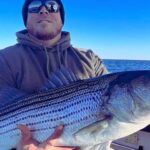
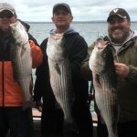
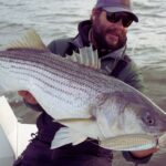
For the seasoned captain, the value of Spring Lake lies in its logistics. You are effectively positioning yourself within a three-mile radius of two major boat launches, allowing for a game-time decision on where to splash the boat. The shoreline here features a specific topography that attracts striped bass and bluefish during the spring and fall runs, often within casting distance of the sand. Unlike the rugged, lava-lined coasts of the Pacific, this is classic Jersey Shore territory: shifting sandbars, distinct cuts in the trough, and a reliance on reading the whitewater. The primary target species driving the local economy include Striped Bass, Fluke (Summer Flounder), and Bluefish, with offshore runs targeting Tuna and Mahi when the window opens.
The operational tempo here is dictated by the seasons and the tides. While the summer months bring crowds to the beaches, the "shoulder seasons" belong to the angler. The infrastructure supporting this fishery is robust but dispersed. You will not find a centralized "Spring Lake Marina" with fuel and ice; rather, you must rely on a network of specialized tackle shops, launch ramps, and support facilities located in the adjacent townships of Belmar, Wall, and Manasquan. Success in these waters requires understanding this decentralized layout and planning your logistics—fuel, bait, and launch—before you hitch the trailer.
Access & Getting There
Reaching Spring Lake is generally straightforward, with the primary artery being the Garden State Parkway. However, the final few miles to the water can be deceptive during peak hours. The most efficient approach for trailering captains is typically exiting the Parkway onto Route 34 or Route 138, filtering toward the coast. Traffic congestion is a genuine variable here, particularly on weekends during the summer season. The "dawn patrol" advantage is real; arriving before 6:00 AM not only secures parking but avoids the infamous Jersey Shore traffic bottlenecks that form on the main state highways leading into Belmar and Manasquan.
💡 Captain's Tip: Trailer Strategy
If you are arriving early or need a staging area before your launch slot opens, utilize the Garden State Parkway Park And Ride in Wall Township. It is open 24 hours and located just 3.8 miles from the fishing grounds, providing ample space to check bearings and rigging away from the tight coastal streets.
Launch Realities and Ramps
For boat owners, the primary access point is the Manasquan Boat Launch, located approximately 2.5 miles south of the central Spring Lake spot. This facility is the workhorse for the area. The ramps are generally well-maintained, but the popularity of the Manasquan Inlet means this location can reach capacity rapidly. The current strength in the Manasquan River can be significant; launching during a ripping outgoing tide requires a steady hand on the throttle and a well-coordinated crew on the lines. There are also unnamed overpass access points noted in the local data roughly 2 miles out, but these are often less developed and better suited for kayaks or light skiffs rather than heavy center consoles.
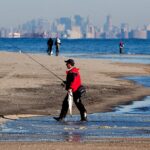
Shore access is excellent for surf anglers. The data indicates multiple shore access points suitable for families and serious casters alike. The beachfront along Spring Lake offers open access, though parking meters and seasonal beach badge requirements are strictly enforced during the day. Night fishing often provides relief from these restrictions, but always verify local signage. The topography of the beach changes with winter storms, so scouting the cuts at low tide is essential for productive high-tide sessions.
Parking and Staging
Parking with a trailer in Spring Lake proper can be challenging due to narrow residential streets and restrictions. The Garden State Parkway Park And Ride mentioned earlier is a critical asset for logistics. For those without trailers, street parking is available but competitive. The data highlights New Frontier Valet in Eatontown, but includes a critical operational note: "Avoid with trailers." Do not attempt to navigate heavy rigs into facilities not designed for them. Similarly, Country Club Services is listed nearby, but verify their lot capacity before committing. For long-term storage or staging during a multi-day trip, Snapbox Self-Storage is located about 17.5 miles away in Manchester Township, offering a secure option if you are staying inland.
Spring Lake, NK Pre-Trip Checklist
Facilities & Amenities
The region surrounding Spring Lake boasts a high density of fishing-specific infrastructure, though it is spread across several towns. You will not find a "one-stop-shop" at the water's edge in Spring Lake itself; instead, you must tap into the surrounding ecosystem of businesses. The caliber of the local fleet is high, with Belmar serving as the home port for many top-tier charter operations.
Bait & Tackle Logistics
The local tackle shops are institutions, catering to distinct styles of fishing. Gabriel Tackle Co. in Brick Township (8.5 miles away) is a reliable hub for inshore and offshore gear, maintaining hours that accommodate the serious angler (opening at 8:00 AM, which is suitable for mid-morning tides or gearing up the day before). For those headed further north or coming from the bay side, TN Tackle in Hazlet offers comprehensive service.
However, for the surfcaster who lives by the tide, Grumpys Tackle in Seaside Park (15.7 miles south) is the gold standard. Their operating hours are optimized for the dawn patrol, opening the doors at 04:30 AM. This is where you go for fresh bunker, custom plugs, and real-time intelligence on the surf bite. Charlies Bait n Tackle in Normandy Beach (10.3 miles) is another excellent option, opening at 7:00 AM. Up Front Bait and Tackle in Keyport is also available for those accessing the area from the north, with a 5:00 AM opening time that respects the early riser.
💡 Captain's Tip: The "Dawn Patrol" Resupply
If you are targeting the sunrise bite, Grumpys Tackle is your only viable option for fresh bait before 5:00 AM. Most other shops in the immediate vicinity do not open until 7:00 AM or 8:00 AM. Plan your bait run the evening before if you intend to fish the immediate Spring Lake surf at first light.
Charter Fleet and Guides
If you prefer to leave the helm to someone else, the charter fleet operating out of the nearby Belmar Marina (just 1.9 miles away) is world-class. Nearfall Fishing Charters and Finominal Sportfishing Charters are located practically next door to the Spring Lake zone. These outfits specialize in striped bass and bottom fishing. Chasin' Tail Sportfishing in Port Monmouth (20.2 miles) and Reel Happy Fishing Charters in Highlands (17.5 miles) are options if you are looking to depart from the Raritan Bay side to target specific migration patterns. The proximity of the Belmar fleet means you can stay in Spring Lake and be at the dock within 10 minutes.
| Facility Name | Type | Distance / Location | Key Notes & Hours |
|---|---|---|---|
| Grumpys Tackle | Bait & Tackle | 15.7 mi (Seaside Park) | Opens 04:30 AM. Essential for early bait. |
| Gabriel Tackle Co. | Bait & Tackle | 8.5 mi (Brick Twp) | Opens 8:00 AM. Solid general outfitter. |
| Manasquan Boat Launch | Boat Ramp | 2.5 mi (Manasquan) | Primary launch. Heavy current awareness required. |
| Nearfall Fishing Charters | Charter | 1.9 mi (Belmar) | Rated 5.0. Very close proximity. |
| Garden State Parkway Park And Ride | Parking | 3.8 mi (Wall Twp) | Open 24 Hours. Good for staging. |
Lodging and Accommodation
Accommodation options directly in the data set lean towards camping and extended stay facilities, reflecting the outdoor nature of the region. Allaire State Park Group Campsite offers a rustic option just 5.1 miles away, perfect for anglers who want to maximize their budget for fuel and gear. For a more structured stay, Pine Grove Day Camp in Wall Township is nearby, though availability for transients should be checked. Javdeck Inc in Jackson Township and Quail Hill Scout Reservation offer alternative lodging logistics further inland. Note that high-end hotel accommodations are not explicitly detailed in this dataset, suggesting that anglers seeking luxury should look to the bed and breakfasts within Spring Lake proper or commercial hotels in Wall Township.
Permits, Regulations & Fees
Navigating the regulatory environment in New Jersey requires attention to detail. The official data indicates that fishing is allowed and managed by the State Fishing Agency. While no specific "Spring Lake" permit is flagged in the system, all saltwater anglers in New Jersey aged 16 and older must register with the New Jersey Saltwater Recreational Registry Program (NJSRRP). This is a free registration but is legally mandatory.
Gateway National Recreation Area (Sandy Hook), located approximately 17 miles north, introduces a different set of federal regulations if your trip takes you that far. The data lists specific fees for amenities like the "Sandy Hook Canoe Cruise" and seasonal beach parking. While Spring Lake itself is municipal, if you launch and run north to fish the Sandy Hook rips or the bay, be aware that you are entering National Park Service jurisdiction. The "Sandy Hook Beach Parking" facility listed has a phone number (732-872-5970) which can be a useful resource for checking real-time access status for the northern barrier spit.
Cultural respect and local ordinances are paramount. Spring Lake is a residential community with strict noise and parking enforcement. The concept of "Kapu" or sacred restriction may not be native to New Jersey, but the local equivalent is the privacy of beachfront homeowners and the strict enforcement of beach badge policies. Accessing the beach via established entry points is not just a courtesy; it is a legal requirement to avoid trespassing fines.
Events & Seasonal Information
The fishing calendar in this region is driven by the migration of Striped Bass. The spring run (April-June) and the fall run (October-December) are the peak operational windows. During these times, the local boat ramps at Manasquan and the charter docks in Belmar operate at maximum capacity. The summer season shifts focus to Fluke (Summer Flounder) and offshore pelagics. The data notes "Sandy Hook Canoe Cruises" during the summer, indicating that the calmer summer waters in the bay allow for paddle sports, which can be a conflict for powerboaters navigating the channels. Keep a sharp lookout for kayak fleets and paddleboards, especially near the inlet jetties during July and August.
💡 Captain's Tip: Summer Traffic
During the summer months, the waterways between Belmar and Manasquan become heavily trafficked recreational zones. The "Canoe Cruise" activities mentioned in the data suggest a high volume of non-motorized vessels. Reduce speed and increase vigilance when transiting the Intracoastal Waterway or near the inlet mouths.
Contact Information & Resources
Self-reliance is the rule, but knowing who to call is essential. For issues regarding the northern reaches and federal lands, the Gateway National Recreation Area contact line is 732-872-5970. For local parking and beach access questions, the municipal authorities in Spring Lake and the harbor masters in Belmar and Manasquan are the primary points of contact. Safety notes emphasize the need to "check weather and ocean conditions before fishing" and "wear appropriate footwear," particularly when navigating the slippery jetties or launching at low tide.
For precise locations, real-time wind conditions, and detailed bathymetry of the nearby inlets, consult the live dashboard and interactive maps below.


Leave a Reply