Skull Valley Fishing Report: Horseshoe Springs WMA
Welcome to the definitive angler's guide for Skull Valley, a unique and often overlooked gem nestled in the western deserts of Utah. While the arid landscape might not immediately scream "prime fishing destination," those in the know recognize the area for its hidden geothermal oases and resilient fish populations. The crown jewel of this region is the Horseshoe Springs Wildlife Management Area. Managed by the Bureau of Land Management, this natural spring system emerges from the Skull Valley fault line, creating a lush, riparian habitat that served as a historic watering hole for pioneers on the Hastings Cutoff. Today, it serves as a fascinating, highly technical micro-fishery for dedicated anglers.
1. GO/NO-GO STATUS
Verdict: GO
Current conditions at Horseshoe Springs dictate a definitive "GO" for anglers willing to employ stealth and finesse. Because this is a geothermal warm spring, the water temperature remains locked at approximately 70 degrees Fahrenheit all year long. This creates a remarkably stable environment where seasonal cold fronts or sudden weather shifts have minimal impact on the water itself. Spring conditions are excellent, as increasing daylight hours trigger heightened insect hatches, bringing the entire aquatic food chain to life.
From the editor
Tired of fishing with strangers you can’t trust?
Nautrek is the first social network for serious anglers — verified partners, real trips, cost splitting and intel sharing without burning your spots. Private beta now open.
Safety and Environmental Advisory: While the water is invitingly warm, the surrounding high desert requires proper preparation. The banks around the spring pools are notoriously steep, muddy, and slippery. Anglers should stick to the established wooden boardwalks whenever possible to avoid tumbling into the brackish water. Furthermore, as the desert heats up, rattlesnake activity in Skull Valley increases dramatically. Always watch your step, avoid reaching blindly into thick brush, and wear sturdy boots. Finally, the biting gnats and mosquitoes can be relentless near the water's edge, so a heavy application of DEET is highly recommended.
2. SPECIES INTEL
Primary Target: Largemouth Bass
The crystal-clear, brackish waters of this desert spring hold a very surprising and localized population of largemouth bass. Because the water visibility is incredibly high, these bass are highly visual, opportunistic feeders that patrol the edges of the dense vegetation. They are notoriously skittish and line-shy. Expect to encounter fish primarily in the 1-to-2-pound class, though a few seasoned 3-pound cruisers hide deep beneath the moss mats.
Sleeper Pick: Common Carp
Most bass anglers completely ignore them, but the spring system sustains a healthy population of large common carp that slowly vacuum the sandy bottoms of the main source pools. If the bass are experiencing lockjaw due to high sun or angling pressure, targeting these golden heavyweights on light tackle provides an incredible, drag-peeling fight in a very confined space.
Baitfish and Forage Report: The forage base in Horseshoe Springs is not your typical shad or bluegill profile. The bass here sustain themselves heavily on aquatic insects, leeches, small frogs, and juvenile fish hiding in the weeds. Matching the hatch means downsizing your presentation and focusing on subtle, natural movements rather than loud, aggressive reaction baits.
3. TACTICAL STRATEGY
Fishing this unique desert spring requires a highly disciplined, finesse-oriented approach. You must treat this fishery more like a high-alpine, technical trout stream than a traditional bass lake. Sight-fishing is the name of the game.
Where to Target
Focus your efforts on the two main source pools that form the namesake "horseshoe" shape, as well as the narrow connecting channels. The absolute best holding zones are the thick mats of green vegetation lining the edges. Do not walk right up to the bank; the fish will spot your silhouette and spook long before you can make a cast. Stand well back from the water's edge or utilize the wooden boardwalk for elevation. Make long casts parallel to the weed lines, and look for small, dark holes or pockets in the vegetation mats to pitch your bait into.
Lure & Bait Selection
Finesse Plastics: A 6-inch finesse worm rigged on a lightweight 3/16-ounce shaky head is deadly here. Alternatively, a weightless Texas-rigged stick bait allows for a slow, horizontal flutter that won't spook wary fish on the fall.
Color Palette: Stick strictly to natural, translucent tones. Green Pumpkin, Watermelon Seed, and Smoke are your best bets. Avoid bright chartreuse or heavy metallic flakes in this gin-clear water.
Carp Tactics: If you pivot to the sleeper carp, a simple hair rig loaded with sweet corn or a small piece of nightcrawler fished dead-stick on the bottom of the main pool is the ticket. Keep your rod tip low and wait for a steady pull.
Timing
The low-light windows of early dawn and late dusk are absolutely critical at Horseshoe Springs. Once the desert sun is high and directly illuminating the clear pools, the bass retreat deep under the vegetation mats and become extremely difficult to coax out. Overcast days or periods of light rain will extend the active bite window significantly.
Pro Tip:Downsize your line immediately. Leave the heavy braided line at home. Spool up with 6-to-8-pound fluorocarbon to remain completely invisible in the clear spring water. If you prefer the sensitivity of braid, you must tie on a micro-swivel and a very long (10 to 12 feet) fluorocarbon leader.
Pro Tip:When pitching into the vegetation holes, let your bait fall on a completely slack line. The strike almost always happens on the initial drop, and any tension from your rod tip will cause the bait to pendulum unnaturally away from the strike zone.
4. REGULATIONS SNAPSHOT
While general statewide fishing regulations apply to this Bureau of Land Management Wildlife Management Area, there are a few site-specific rules and strong ethical guidelines that every visiting angler must respect:
Species
Size Limit
Bag Limit
Special Site Rules
Largemouth Bass
No minimum size
Statewide limits apply
Catch and release strongly encouraged
Common Carp
None
No limit
Do not discard fish on the boardwalk
Conservation Note: Because this is a fragile, isolated micro-fishery in the middle of a harsh desert, harvest can quickly and permanently decimate the local bass population. Catch and release is strongly urged by local guides and conservationists to preserve the resource. Furthermore, despite being a warm spring, swimming, wading, and soaking are strictly prohibited by the BLM. The site is managed strictly for riparian habitat, historical preservation, and wildlife viewing.
5. REGIONAL ALTERNATIVE
If you arrive at Horseshoe Springs and find the small parking lot full, or if the clear-water bass are simply too spooked to bite, you have excellent backup options just a short drive away in Tooele County.
Grantsville Reservoir
Located to the east toward the Stansbury Mountains, Grantsville Reservoir offers a completely different angling experience. This is a classic, cooler-water reservoir that is regularly stocked with Rainbow Trout by the Division of Wildlife Resources.
Target Species: Stocked Rainbow Trout and the occasional wild Brown Trout.
Access: The reservoir features easy, sloping shoreline access with plenty of room to spread out, plus a primitive boat ramp for small, non-motorized watercraft and float tubes.
Tactical Approach: Throw 1/8-ounce to 1/4-ounce inline spinners (gold blades with dark bodies work best) along the rocky dam face. If you prefer bait fishing, float traditional garlic-scented dough bait on a slip-sinker rig near the inlet. The water here is cooler and slightly more stained, making the mid-day bite much more forgiving than the ultra-clear springs of Skull Valley.
Pro Tip:Always keep a secondary rod rigged with a small flashy spoon or spinner when visiting Tooele County waters. If the finesse bass bite dies at the springs, you can easily pivot to the reservoir, hike the banks, and immediately start covering water for aggressive stocker trout without needing to re-tie your entire setup.
Tight lines!
Editor's Choice: Must-Have Gear
FISHINGSIR Next-Gen Waterproof Chest Waders
β β β β β 4.4 (7,370+ reviews)
2-Ply Tech: Upgraded nylon with 2.5x higher density than standard fabrics.
100% Waterproof: Lab-approved intrusion resistance with taped visible seams.
Ultra-Lightweight: Designed for all-day comfort while hunting or fishing.
As an Amazon Associate I earn from qualifying purchases. #ad
Loading forecast...
Live Fishing Conditions: Tides, Weather & Waves
Get realβtime tides, marine weather, swell and solunar activity for each spot so you know exactly when conditions line up for your best chance at a bite.
π£
Skull Valley
Loading coordinates...
π€οΈ
WEATHER CONDITIONS
--Β°F
--Β°C
Loading...
π‘οΈ
Feels Like--Β°F--Β°C
π§
Humidity--%
π¨
Wind-- mph-- km/h
π§
Direction--
π
Pressure-- inHg-- hPa
βοΈ
UV Index--
π
MARINE CONDITIONS
πWave Height
-- ft
-- m
Loading...
π§Wave Direction
--Β°
Loading...
β±οΈWave Period
-- s
Loading...
πTide Status
-- ft
-- m
Loading...
π
LUNAR & SOLUNAR
π
Loading...
Illumination: --%
Major Period--:-- - --:----:-- - --:--
Minor Period--:-- - --:----:-- - --:--
π Sunrise--:--
πSunset--:--
π
24-HOUR FORECAST
Loading fishing conditions...
Fishing Spots Map
π£
Book a Fishing Charter near Skull Valley Fishing Report Today π£
Local guides & charters. Verified captains, instant booking, best price guaranteed.
There was an error loading the map. Please try refreshing the page.
Info
Local Access & Facilities
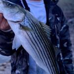
Skull Valley represents a unique logistical hub for the serious Arizona anglerβa high-desert gateway that serves as the "back door" to the productive fisheries of the Prescott National Forest. Unlike the manicured marinas of the Colorado River, this location is defined by its rugged, ranch-land atmosphere, towering cottonwoods, and the historic railway lines that cut through the silence of the valley. It is not a fishery where you cast from your hotel balcony; it is a staging ground for expeditions into the surrounding elevations where lakes like Granite Basin and Watson Lake hold populations of largemouth bass, crappie, and rainbow trout.
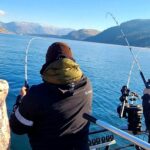
The vibe here is distinctly Western and utilitarian. The air is thinner, the terrain is red dirt and scrub oak, and the pace is dictated by the sun and the ranching calendar. For the seasoned captain or kayak angler, Skull Valley offers a strategic launchpad that avoids the urban congestion of central Prescott while providing access to the western slopes of the Bradshaws. The primary targets here are cool-water species in the reservoirs and creek fishing in the riparian zones during wet years, requiring a versatility in tackle that ranges from ultra-light spinning gear for trout to heavy cover jigs for structure-oriented bass.
Anglers utilizing this area are typically mobile, trailering aluminum boats or hauling kayaks in truck beds. The topography demands respect; this is canyon country where weather shifts rapidly, and access points are often located at the end of winding forest service roads. Understanding the relationship between the valley floor's staging potential and the higher elevation water bodies is the key to unlocking the fishing potential of this region.
Access & Getting There
Reaching Skull Valley generally involves traversing Iron Springs Road, a route that is as scenic as it is demanding for those towing heavy loads. This two-lane artery winds through the mountains, connecting the heat of the lower deserts with the cool air of the uplands. Experienced drivers know that the switchbacks require vigilant brake management and a vehicle with sufficient torque. Traffic here is generally light, but during summer weekends, the flow of recreational vehicles and horse trailers can create bottlenecks, particularly on the steeper grades approaching the Iron Springs facility.
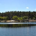
While Skull Valley itself serves as the geographic anchor, the actual water access points are dispersed through the surrounding National Forest. The data indicates boat launch facilities approximately 11 to 15 miles from the town center, placing destinations like Granite Basin Recreation Area within a tactical striking distance. The "launch realities" here are rustic; do not expect multi-lane concrete mega-ramps with wash-down stations. Instead, prepare for improved dirt or single-lane paved ramps where traction can be an issue after summer storms. For kayak anglers, the Flinn Park area and various shoreline access points offer gentler entries, though carrying gear over uneven terrain is often required.
π‘ Captain's Tip: Trailer Management
When descending into the valley via Iron Springs Road, gear down early. The winding grades can overheat trailer brakes quickly. Local pros check their hubs immediately upon arrival at the staging area to ensure bearings haven't cooked during the descent.
Weather plays a critical role in access logistics in this high-desert environment. The region is prone to the North American Monsoon season in late summer, where violent thunderstorms can materialize in early afternoon. These storms bring flash flood risks to low-lying crossings and washes. A dry creek bed in the morning can become an impassable torrent by 2:00 PM. Furthermore, high winds often sweep through the valley and over the nearby lakes; when sustained winds exceed 15-20 mph, the exposed waters of the local reservoirs can become choppy and dangerous for small craft.
Parking in this rural sector requires a strategy distinct from urban harbors. The Metate Trailhead Parking and Turley Trail Trailhead Parking offer designated spots, but they are primarily designed for hikers and equestrians. Anglers towing boats must arrive earlyβoften before sunriseβto secure a spot that allows for a pull-through or an easy back-in without blocking the flow. Skull Valley Park, located right in the heart of the location, serves as an excellent rendezvous point for convoys or for checking gear before the final push to the water.
Skull Valley Pre-Trip Checklist
Facilities & Amenities
The infrastructure in Skull Valley is minimal, catering more to the self-reliant outdoorsman than the resort tourist. This is "bring-what-you-need" country. There are no specialized big-game tackle shops or marine mechanics located directly in the hamlet. Anglers must rely on their own inventory, ensuring all terminal tackle, live bait, and spare parts are purchased in larger hubs like Prescott before descending into the valley. The US Forestry Department office listed in the area is a resource for information, not retail, so don't expect to buy a fishing license over the counter there at 5:00 AM.
Accommodations in the immediate vicinity reflect the rural character of Yavapai County. Groom Creek Horse Camp offers a rustic overnight option for those willing to camp, situated about 14 miles away. This is ideal for anglers who want to be on the water at first light without the commute from the city. For a more unique stay, the Gold Bar Cattle Ranch provides a glimpse into the local heritage, though availability should be checked well in advance. The Skull Valley Park offers local amenities closer to the pin, but it is primarily a day-use community asset rather than a campground.
π‘ Captain's Tip: Fuel Logistics
There are no marine fuel docks in this sector. Top off your boat tanks and jerry cans in Prescott or Wickenburg before entering the valley. Running out of gas on a forest service road here means a long hike with a gas can.
Below is a breakdown of the key facilities available to anglers in the Skull Valley vicinity. Note the distinction between parking areas and actual accommodation or service centers.
Facility Name
Type
Distance / Location
Angler Notes
Skull Valley Park
Day Use / Local Park
Immediate (448 ft)
Excellent staging area for gear checks; open 10am-4pm (Mon-Sat).
Metate Trailhead
Parking / Access
10.8 miles
Key access point for forest entry; limited trailer space.
Groom Creek Horse Camp
Camping
14.2 miles
High-elevation camping option; allows for early alpine starts.
Watson Lake Vista
Parking / Viewpoint
15.8 miles
Paved parking; proximity to major water body (Watson Lake).
US Forestry Dept
Agency Office
18.1 miles
Information on road closures and fire restrictions.
It is vital to note the "Negative Knowledge" regarding this location: there are no fish cleaning stations, no lighted docks for night fishing, and scarce public restrooms once you leave the main trailheads like Turley Trail. Anglers must practice "Leave No Trace" principles strictly, packing out all line, lead, and biological waste. The lack of commercial amenities is the price paid for the solitude found in this sector.
Permits, Regulations & Fees
Fishing in the Skull Valley region falls under the jurisdiction of the Arizona Game and Fish Department. A valid state fishing license is mandatory for all anglers 10 years of age and older. Because the access points often traverse the Prescott National Forest, anglers must also be cognizant of federal land use fees. Many of the developed recreation sites, such as Granite Basin or Thumb Butte, require a Tonto Pass or a specific day-use fee which must be displayed on your vehicle's dashboard. Electronic kiosks are becoming more common, but carrying small bills for self-pay iron rangers is a hallmark of the prepared local.
The regulations here are strictly enforced to protect the delicate high-desert ecosystems. Specific attention should be paid to "Kapu" or restricted areas, particularly regarding private lands. Skull Valley is a patchwork of public forest and private ranch land. Crossing a fence line to reach a creek without permission is not just illegal; it is a breach of the deep-seated cultural respect for property rights in rural Arizona. Stick to marked Forest Service roads and designated access points like Metate Trailhead to remain compliant.
π‘ Captain's Tip: Fire Safety
This is high fire danger country. During dry months (May-June), strict fire bans are often in effect. This includes smoking outside of enclosed vehicles and sometimes even the use of charcoal grills at campsites. Always check current Forest Service restrictions before towing up.
Protected zones include areas around Thumb Butte, where nesting peregrine falcons may trigger seasonal closures of cliff faces and nearby trails. While this impacts climbers more than anglers, it reflects the conservation-first management style of the area. Additionally, be aware of seasonal stocking schedules for the nearby lakes; regulations regarding daily bag limits for trout can change based on the season and the specific body of water (e.g., catch-and-release only seasons).
Events & Seasonal Information
The angling rhythm in Skull Valley is dictated by the dramatic seasonal shifts of the Arizona highlands. Spring (March-May) is often the prime window, as water temperatures in the nearby reservoirs rise, triggering the pre-spawn staging for largemouth bass. This is also when the trout stocking programs are most active, drawing anglers to the shorelines of Watson and Granite Basin. The cottonwoods in the valley leaf out, and the wind is generally manageable in the early mornings.
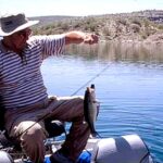
Summer brings the heat, pushing the bite into the nocturnal hours or the very first light of dawn. This is "Dawn Patrol" territory; seasoned skippers are launching by 4:30 AM and are off the water by 10:00 AM when the recreational boat traffic and solar intensity peak. The late summer "Monsoon Season" (July-August) introduces a wild card: afternoons are characterized by dramatic thunderheads. While the pressure drops can trigger feeding frenzies, the lightning risk is severe. Never be the tallest object on a high-desert lake during a monsoon build-up.
Winter fishing is for the hardy. Snow is possible in Skull Valley and likely at the higher elevations of the access roads. However, for those targeting trophy trout or winter crappie schools suspended in deep water, the solitude is unmatched. There are few formal tournaments held directly in Skull Valley due to the lack of water, but the nearby Prescott lakes host local bass club events and kayak fishing series, usually peaking in the spring and fall months.
Contact Information & Resources
For the most current information on road conditions and fire restrictions, the primary authority is the Prescott National Forest. Their offices can provide real-time updates on gate closures, which are common during winter snows or high fire danger periods. The Arizona Game and Fish Department is your source for stocking reports and licensing.
Emergency: 911 (Note: Cell service is spotty in canyons; satellite messengers are recommended).
Forest Management: US Forestry Department (Prescott Office).
Local Parks: Skull Valley Park Management (for local day-use inquiries).
Self-reliance is the rule here. Ensure your spare tire is inflated, your battery is charged, and you have ample water. The beauty of Skull Valley lies in its remoteness, but that same isolation demands preparation. For precise locations, trailheads, and real-time weather conditions, consult the live dashboard and interactive maps below.
Our spot reports combine data-driven forecasts with curated local information. The forecast is generated by our proprietary Fishing Score algorithm (0β100%), which analyzes real-time data from Open-Meteo API, validated against NOAA CO-OPS tide gauges and USGS water-monitoring stations. The model weights tide dynamics (35%), wave energy (25%), wind patterns (20%) and time of day (20%)βfactors shown to influence fish feeding behavior through marine-biology research and decades of charter log data.
Access, facilities and services information for each fishing spot is sourced from official datasets such as Recreation.gov (RIDB), state park & wildlife agencies, and geospatial providers like Google Maps. These sections undergo scheduled re-validation every 3β6 months to ensure that boat ramps, park access, contact details and local services remain accurate.
Narrative sections (catches, seasonal behavior, local tips) are synthesized from these data sources and refined following the Fishing Reports Today editorial guidelines, combining bibliographic research from ichthyology and oceanography with expert angler experience. Our team reviews reports on a regular basis, while the forecast model itself updates every 6 hours for real-time accuracy.
β οΈ Important: Always verify current local regulations, access restrictions and weather conditions before fishing. These reports are intended as a planning aid, not a guarantee of catches or safety. When in doubt, contact local authorities or park managers listed on the page.
To provide the best experiences, we use technologies like cookies to store and/or access device information. Consenting to these technologies will allow us to process data such as browsing behavior or unique IDs on this site. Not consenting or withdrawing consent, may adversely affect certain features and functions.
Functional Always active
The technical storage or access is strictly necessary for the legitimate purpose of enabling the use of a specific service explicitly requested by the subscriber or user, or for the sole purpose of carrying out the transmission of a communication over an electronic communications network.
Preferences
The technical storage or access is necessary for the legitimate purpose of storing preferences that are not requested by the subscriber or user.
Statistics
The technical storage or access that is used exclusively for statistical purposes.The technical storage or access that is used exclusively for anonymous statistical purposes. Without a subpoena, voluntary compliance on the part of your Internet Service Provider, or additional records from a third party, information stored or retrieved for this purpose alone cannot usually be used to identify you.
Marketing & Affiliates
The technical storage or access is required to create user profiles to send advertising, or to track the user on a website or across several websites for similar marketing purposes, including affiliate tracking for products recommended in our reports.
Leave a Reply