


Mingus Lake: Alpine Angling in the Arizona High Country
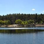
Perched high above the heat of the Verde Valley, Mingus Lake offers a distinct high-altitude fishery that contrasts sharply with the desert reservoirs typical of Arizona. Sitting at an elevation of approximately 7,500 feet within the Prescott National Forest, this water body is less about high-speed bass boats and more about the quiet, calculated approach of the alpine angler. The lake is enveloped by a dense stand of Ponderosa pines, providing a windbreak and a scenic backdrop that feels worlds away from the cactus-studded plains below.
The atmosphere here is defined by thin, cool air and the scent of pine needles baking in the sun. Unlike the sprawling impoundments of the lower Colorado River, Mingus Lake is an intimate setting where stealth and presentation are paramount. The water here is stocked, primarily targeting trout anglers looking for a cool-weather bite even during the peak of summer. The surrounding terrain is rugged and steep, a testament to the geological forces that shaped the Black Hills, offering a fishing experience that requires a bit of logistical planning regarding weather and altitude.
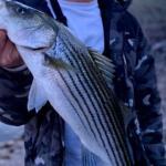
For the seasoned captain or serious angler, Mingus Lake represents a technical shift. The primary game here involves stocked trout, but the challenge lies in the conditions. The high elevation means weather patterns can shift rapidly from calm sunshine to mountain thunderstorms. This is a location for those who appreciate the solitude of the forest and the technical aspects of light-tackle fishing in clear, mountain waters. It serves as a quiet respite and a testing ground for finesse techniques.
Access & Getting There
Reaching Mingus Lake is an adventure in itself and requires a vehicle capable of handling significant elevation gains and winding mountain roads. The primary artery for access is State Highway 89A. This historic route connects the Prescott Valley to the Verde Valley and is renowned for its steep grades and tight curves. If you are towing a small vessel or a travel trailer, extreme caution is advised. The road is narrow in places, with hairpin turns that demand the full attention of the driver. Seasoned haulers know to check their brake systems thoroughly before descending into Jerome or Cottonwood.
From the town of Prescott, you will travel north past the Granite Dells, turning right onto Highway 89A and climbing approximately 20 miles to the summit of Mingus Mountain. The ascent is rigorous, and traffic can bottleneck behind slow-moving heavy trucks or recreational vehicles. Once you reach the summit area, access to the lake and campgrounds is via Forest Road 104 and Forest Road 106. These are Forest Service roads, and while generally maintained, conditions can deteriorate after heavy summer monsoons or winter snowmelt.
💡 Captain's Tip: Trailer Management
Highway 89A features tight hairpin turns and few pull-offs. If you are towing a trailer longer than 25 feet, approach the switchbacks near Jerome with extreme caution. Local knowledge suggests using the lower gears to save your brakes on the steep descent.
Parking at the lake itself is relatively informal compared to major marinas. The Mescal Trail #547 Parking area, located about 2.5 miles from the main recreational hub, serves as a reference point for the general vicinity, but anglers should look for designated turnouts near the Potato Patch Campground entrance. During peak summer weekends, these spots fill rapidly. The "dawn patrol" strategy is essential here; arriving by 5:00 AM not only secures a spot near the water but also allows you to fish the prime low-light window before the recreational hikers and picnickers arrive.
Weather is the single biggest factor dictating access to Mingus Lake. Due to the high altitude, winter snows can render the Forest Service roads impassable. The lake often freezes or becomes inaccessible during the deep winter months. Conversely, the summer monsoon season brings heavy afternoon thunderstorms. The road surfaces on FR 104 and FR 106 can become slick mud instantly during a downpour. It is critical to monitor the forecast for the Verde Ranger District before hitching up.
Mingus Lake, AZ Pre-Trip Checklist
Facilities & Amenities
Infrastructure around Mingus Lake is designed for the self-reliant angler. This is not a location with a full-service marina, fuel docks, or lakeside dining. The facilities are rugged and focused on camping and basic access. The nearest substantial amenities, including fuel and specialized marine repair, are located miles away in the towns of Cottonwood, Clarkdale, or Prescott. You must arrive with full fuel tanks and all necessary provisions.
The crown jewel of the local infrastructure is the Potato Patch Campground. Situated just across the highway from the lake, this facility offers the highest level of comfort in the immediate area. It features paved parking and, crucially, Loop B offers electrical hookups (30 amp), which is a rarity in such remote forest settings. For anglers planning a multi-day trip, securing a site in Loop B is the strategic move for keeping trolling motor batteries charged. Note that Potato Patch is currently the only site on the mountain with available potable water, a vital logistical detail for those staying at other nearby primitive sites.
💡 Captain's Tip: Supply Chain Reality
There are no bait shops or tackle vendors on the mountain. The nearest gear is over 19 miles away at Canyon Outfitters in Sedona or Sportsman's Warehouse in Prescott. Stock up on PowerBait, spinners, and fluorocarbon leaders before you leave the valley floor.
For larger groups or fishing clubs, the Playground Group Campground offers a secluded setting capable of hosting up to 75 people. However, be aware that this site has no drinking water and utilizes vault toilets. It sits at 7,500 feet, offering spectacular views of the Verde Valley, but requires you to haul in every drop of water you intend to use. The Mingus Mountain Camp is another option, primarily for tent camping and smaller setups. The table below details the specific amenities available at the key locations nearby.
| Facility Name | Type | Distance | Key Amenities & Notes |
|---|---|---|---|
| Potato Patch Campground | Campground | 3.1 mi | Paved parking, 30 Amp electric (Loop B), potable water, vault toilets. Best basecamp for anglers. |
| Playground Group | Group Camp | 2.4 mi | Capacity for 75 people, gravel driveways, large fire pit. No water available. |
| Mingus Mountain Camp | Campground | 2.7 mi | Scenic views, hiking access. No water available. |
| PRAM LLC | Parking | 5.8 mi | Located in Cottonwood. Useful for overflow or trailer storage if needed. |
The "Negative Knowledge" regarding this location is substantial. There is no boat ramp suitable for trailered vessels at Mingus Lake; it is strictly a car-topper, kayak, or float tube fishery. Do not tow a heavy bass boat up the mountain expecting to launch. Additionally, there are no fish cleaning stations or trash disposal services at the water's edge. This is a "pack it in, pack it out" fishery. The nearest specialized fly shop support is Sedona Fly Fishing or Canyon Outfitters, both located a significant drive away in the valley.
Permits, Regulations & Fees
Fishing at Mingus Lake falls under the jurisdiction of the state wildlife agency, and standard state fishing licenses are required for all anglers. The lake is managed as a recreational resource within the Prescott National Forest, meaning that federal land use rules also apply. The "fishing allowed" designation is active, but anglers should always verify current bag limits, particularly for trout, as these can change based on stocking schedules and water conditions.
There are specific fees associated with the developed recreation areas. The campgrounds, including Potato Patch and Playground Group, operate on a fee basis and many sites are reservable. Given the popularity of the area during the summer escape season, reservations are highly recommended. While day-use fishing at the lake generally does not require a specific federal permit beyond your state fishing license, parking in developed campground day-use areas may incur a "Red Rock Pass" or similar recreational fee depending on the specific lot used. Always check the signage at the entrance kiosk.
💡 Captain's Tip: Fire Restrictions
During dry summer months, strict fire bans are often enforced in the Prescott National Forest. Propane stoves may be allowed, but charcoal and wood fires are frequently prohibited. Check current fire restrictions with the Verde Ranger District before planning a shore lunch.
Cultural respect is paramount in this region. The Verde Valley and surrounding mountains are ancestral lands with deep significance. Nearby sites like Tuzigoot National Monument and Montezuma Castle National Monument preserve the history of the Sinagua people who thrived here a thousand years ago. When fishing or hiking near the lake, respect all boundaries, do not disturb rock formations, and treat the land with the reverence due to a place of such historical continuity. The concept of stewardship is vital to keeping these high-elevation waters open and productive.
Events & Seasonal Information
The rhythm of life and fishing on Mingus Mountain is dictated entirely by the seasons. The prime fishing window opens in late spring, usually May, once the snow has cleared from the north-facing slopes and the access roads have dried. This is when the trout bite is most active, fueled by the fresh snowmelt and cool water temperatures. As summer progresses into June and July, the "monsoon" season begins. Anglers should aim to be off the water and near shelter by early afternoon, as violent electrical storms are common and dangerous at this exposed elevation.
Fall brings a second peak in activity. As the Aspen trees turn gold and the temperatures drop, the fish become active again in preparation for winter. This is arguably the most beautiful time to fish Mingus Lake, with crisp air and fewer crowds. By late November, the threat of winter storms increases, and access becomes unreliable. The Verde Ranger District may close gates seasonally to protect road surfaces and public safety.
While there are no major professional bass tournaments held on this small water, the area is a hub for recreational events. The campgrounds often host large groups, and the Mingus Hang Glider Launch nearby draws spectators and aviation enthusiasts, adding a unique dynamic to the skyline. For the angler, the "event" is often the stocking schedule. Local forums and state agency reports are the best way to time your trip to coincide with fresh deliveries of trout.
Contact Information & Resources
For the most current information on road closures, fire restrictions, and campground availability, direct contact with the managing agencies is essential. The primary authority for the land surrounding the lake is the Prescott National Forest, Verde Ranger District.
- Verde Ranger District Office: Located in Camp Verde. Phone: (928) 567-4121.
- Tuzigoot National Monument: For historical context and regional info. Phone: (928) 634-5564.
- Montezuma Castle National Monument: Phone: (928) 567-3322.
In terms of safety, cell phone reception can be spotty in the deep timber and canyons of Mingus Mountain. It is advisable to file a float plan with someone back home. Emergency medical services are dispatched from the valley floor, meaning response times can be lengthy. Carry a basic first aid kit and be self-sufficient. Access to the lake involves nature at its most rugged; respect the altitude, stay hydrated, and keep an eye on the horizon for weather changes.
For precise locations, real-time weather updates, and detailed interactive maps of the boat access points and campgrounds mentioned above, consult the live dashboard and widgets below.


Leave a Reply