Perth Amboy to Atlantic Highlands Fishing Report Today 🎣
9 months ago · Updated 1 week ago

Raritan Bay to Atlantic Highlands: Comprehensive Fishing Intelligence
As a professional guide navigating the dynamic waters from the industrial stretches of Perth Amboy down to the scenic Atlantic Highlands, I can confidently report that the early summer transition is in full swing. The Raritan Bay ecosystem is currently teeming with life. The convergence of steadily warming water temperatures and massive influxes of forage has created a highly productive fishery. Whether you are running a large center console out of the Highlands, working the shorelines near Keyport, or drifting the flats near Perth Amboy, the bite is highly active. This estuary is one of the most vital marine environments on the East Coast, and right now, it is showing exactly why it holds that reputation.
1. GO/NO-GO STATUS
Verdict: GO WITH AFTERNOON CAUTION
The current conditions dictate a definitive green light for anglers, but seasonal weather patterns require strategic planning. The mornings are generally slick and calm, providing ideal conditions for running across the open bay and exploring the outer reaches near Sandy Hook. However, as the mainland heats up, afternoon thermal sea breezes can kick up a sharp, steep chop, turning the open water into a washing machine. Furthermore, pop-up thunderstorms can roll off the New Jersey mainland with very little warning.

For larger center consoles and sportfishing vessels, the open bay and ocean side are a clear go. For kayak anglers and those in small skiffs, exercise caution past mid-day. If the wind shifts hard out of the south or northwest and exceeds fifteen knots, plan to stay tucked inside the protection of the hook or navigate up the Navesink and Shrewsbury rivers. Water temperatures are comfortably climbing into the upper sixties, but safety and situational awareness remain paramount.
2. SPECIES INTEL
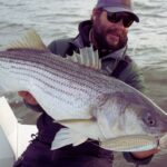
Primary Targets: Striped Bass & Summer Flounder
The undisputed king of the local waters remains the Striped Bass. We are still seeing a solid push of large, migratory linesiders mixing with the resident population. These fish are aggressively feeding before pushing further out into the ocean or heading north. Simultaneously, the Summer Flounder (fluke) bite is heating up significantly. As the shallow mud flats warm up, the fluke are moving out of the deep channels and setting up on the channel edges to ambush prey.
Sleeper Pick: Weakfish
While the fleet chases stripers and fluke, the weakfish bite is quietly producing excellent results. Often overlooked, these beautiful tide-runners are holding in the deeper holes of the tidal rivers and the back-bay channels. They offer fantastic light-tackle action and are a perfect target when you want to get away from the heavy boat traffic.
Baitfish Report
The bay is currently a veritable buffet. Matching your presentation to the specific forage is the key to consistent hookups. We are currently marking:
- Adult Atlantic Menhaden (Bunker): Tightly packed schools throughout the deeper channels.
- Peanut Bunker: Nervous pods pushing through the shallow flats and river mouths.
- Sand Eels: Holding in the sandy stretches near the hook.
- Squid: Present in surprising numbers over the deeper reefs and rock piles.
3. TACTICAL STRATEGY
Where to Deploy
If you are hunting for trophy Striped Bass, focus your efforts around the Shrewsbury Rocks and the deeper channel edges like the Chapel Hill Channel and Swash Channel. Look for the distinct drop-offs where the current creates rips and funnels the bait. For those running out of Perth Amboy, the waters around the Great Beds Lighthouse and the edges of the Raritan River channel are holding solid numbers of resident fish. If you are targeting fluke, the Navesink and Shrewsbury rivers are currently holding warmer water and producing quality keepers. Work the eight to fifteen-foot drop-offs where the tidal current sweeps bait off the shallow flats.
Lure Selection & Color
For fluke, a half-ounce to three-quarter-ounce bucktail jig paired with a teaser hook tied eighteen inches above the main jig is absolutely deadly. Tip both with a five-inch scented soft plastic grub. In clear water conditions, stick to natural patterns like white, pearl, and silver to mimic sand eels and spearing. If the water is stained from recent rains or heavy tidal flow, switch to chartreuse or pink shine, which is currently the hottest color in the bay. For weakfish, a quarter-ounce leadhead paired with a four-inch pink or bubblegum soft plastic jerk shad is the ticket.
Bait & Rigging
Live eels are the absolute top producer for big striped bass right now, especially when drifted over dark bottom structure or rocks. Hook the eel through the lips with an inline circle hook to ensure a healthy release. For bluefish and resident bass, fresh bunker chunks fished on a fish-finder rig remain highly effective. When bottom fishing for black sea bass on the nearshore reefs, tipping your high-low rigs with fresh squid strips is currently out-fishing standard clam baits.
Timing the Bite
Tide is everything in this estuary. The last two hours of the incoming tide and the first two hours of the outgoing tide are providing the most consistent action, as the moving water pulls bait out of the marshes and into the strike zones. Fish the low-light periods of dawn and dusk for the best topwater and shallow-water bass bite. Conversely, the mid-day sun is actually preferable for fluke fishing, as the solar radiation warms the shallow flats and stimulates their metabolism. Pay attention to the moon phases; the stronger tidal pulls around the full

FISHINGSIR Next-Gen Waterproof Chest Waders
- 2-Ply Tech: Upgraded nylon with 2.5x higher density than standard fabrics.
- 100% Waterproof: Lab-approved intrusion resistance with taped visible seams.
- Ultra-Lightweight: Designed for all-day comfort while hunting or fishing.
✓ Amazon's Choice | 100+ bought last month
Bandit Walleye Deep
Mandatory for reaching deep schools in 35-50ft mud flats.
Check Price on Amazon #adAs an Amazon Associate I earn from qualifying purchases. #ad
Live Fishing Conditions: Tides, Weather & Waves
Get real‑time tides, marine weather, swell and solunar activity for each spot so you know exactly when conditions line up for your best chance at a bite.
Perth Amboy to Atlantic Highlands
Loading coordinates...
WEATHER CONDITIONS
Loading...
MARINE CONDITIONS
LUNAR & SOLUNAR
Loading...
Illumination: --%
24-HOUR FORECAST
Fishing Spots Map
Local guides & charters. Verified captains, instant booking, best price guaranteed.
Local Access & Facilities
Perth Amboy to Atlantic Highlands
Parking
Bait & Tackle
Fishing Charters
Lodging
Boat Ramps
Restrooms
Family Friendly
Accessibility
Wheelchair Access
Not Confirmed
Pets Allowed
Not Permitted
⚠️ Some accessibility info not officially confirmed. Please verify with location directly.
Local guides & charters. Verified captains, instant booking, best price guaranteed.
Nearby Spots


About Our Fishing Reports & Forecasts
Our spot reports combine data-driven forecasts with curated local information. The forecast is generated by our proprietary Fishing Score algorithm (0–100%), which analyzes real-time data from Open-Meteo API, validated against NOAA CO-OPS tide gauges and USGS water-monitoring stations. The model weights tide dynamics (35%), wave energy (25%), wind patterns (20%) and time of day (20%)—factors shown to influence fish feeding behavior through marine-biology research and decades of charter log data.
Access, facilities and services information for each fishing spot is sourced from official datasets such as Recreation.gov (RIDB), state park & wildlife agencies, and geospatial providers like Google Maps. These sections undergo scheduled re-validation every 3–6 months to ensure that boat ramps, park access, contact details and local services remain accurate.
Narrative sections (catches, seasonal behavior, local tips) are synthesized from these data sources and refined following the Fishing Reports Today editorial guidelines, combining bibliographic research from ichthyology and oceanography with expert angler experience. Our team reviews reports on a regular basis, while the forecast model itself updates every 6 hours for real-time accuracy.
⚠️ Important: Always verify current local regulations, access restrictions and weather conditions before fishing. These reports are intended as a planning aid, not a guarantee of catches or safety. When in doubt, contact local authorities or park managers listed on the page.
Leave a Reply