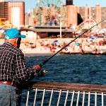
Welcome to the definitive guide for fishing Canarsie Pier. Situated in the heart of Brooklyn, this historic 600-foot structure juts directly into the nutrient-rich waters of Jamaica Bay, providing shore-bound anglers with unparalleled access to migratory travel lanes and deep-water channels. As we settle into the core summer months, the bay's ecosystem is firing on all cylinders. Rising water temperatures have drawn massive schools of forage into the estuary, and the apex predators have followed suit. Based on our latest habitat analysis and seasonal migration tracking, here is your comprehensive, tactical breakdown for maximizing your success on the concrete this season.
1. GO/NO-GO STATUS
Verdict: GO
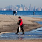
Current seasonal conditions dictate a definitive "GO" for Canarsie Pier. The summer weather patterns have stabilized the water temperatures in Jamaica Bay, creating an incredibly active feeding environment. Safety is paramount, and the pier offers a highly secure, family-friendly platform with sturdy railings and ample lighting for night shifts. Weather impacts are currently standard for the summer season—expect warming surface temperatures during the midday sun, which pushes fish deeper into the adjacent channels. Wind direction plays a crucial role here; a southerly breeze will push bait directly toward the pier, igniting feeding frenzies within casting distance. Anglers should exercise standard caution during afternoon pop-up thunderstorms, as the exposed concrete pier is not a place you want to be when lightning is present.
From the editor
Tired of fishing with strangers you can’t trust?
Nautrek is the first social network for serious anglers — verified partners, real trips, cost splitting and intel sharing without burning your spots. Private beta now open.
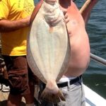
Primary Target: Summer Flounder (Fluke) Fluke are currently the undisputed kings of the pier. These aggressive flatfish have moved into the bay to feed heavily on the abundant baitfish populations. They are actively staging along the sandy bottom transitions and drop-offs surrounding the structure, waiting to ambush prey swept by the tidal currents.
Sleeper Pick: Weakfish (Sea Trout) While the crowds are busy bouncing heavy sinkers for fluke or casting large chunks for bluefish, the discerning angler can find gorgeous weakfish hunting in the shadows. These "tide runners" are the true sleeper pick of the summer. They possess incredibly soft mouths and require a finesse approach, but the reward of landing one of these iridescent beauties is unmatched.
Baitfish Report: The forage base in Jamaica Bay is currently robust. We are seeing massive schools of Atlantic menhaden (bunker) cruising the shorelines, periodically erupting when harassed by bluefish. Additionally, the pilings are teeming with spearing (silversides) and killifish. Matching your presentation to these specific baitfish profiles is the key to triggering strikes from wary gamefish.
3. TACTICAL STRATEGY
To fish Canarsie Pier like a pro, you must abandon the "cast and wait" mentality and adopt a highly specific, targeted approach. The pier sits adjacent to the deep waters exiting Paerdegat Basin, creating distinct current seams and depth changes.
Where to Cast
Do not simply cast blindly straight off the end of the pier. The most productive zone for fluke is the 15 to 20-foot drop-off located off the southeastern corner of the structure. This is where the muddy shallows transition into the harder, sandy channel edge. For porgy (scup) and black sea bass, drop your rigs straight down parallel to the concrete pilings—these fish hold tight to the vertical structure to feed on barnacles and crustaceans.
Lure Selection and Color
For fluke, leave the heavy three-way sinker rigs at home. Opt for a 1/2 oz to 3/4 oz Spro Prime Bucktail Jig in glow-white or chartreuse. Tip this bucktail with a 4-inch Gulp! Swimming Mullet in Chartreuse or Pearl White. The water in Jamaica Bay often carries a slight stain during the summer, making high-visibility UV colors incredibly effective. For targeting bluefish, keep a 1.5 oz chrome Diamond Jig or a bone-colored topwater popper tied on a backup rod, ready to deploy the second you see birds diving.
Pro Tip: To avoid the notorious Jamaica Bay green crabs destroying your soft plastics, keep your bucktails moving constantly. A static bait on the bottom is a stolen bait. Employ a sharp, rhythmic twitching motion to make the jig dart erratically just inches off the sand.
Bait and Rigging
If you prefer fishing meat, live spearing or killifish fished on a high-low rig is deadly for summer flounder. For those targeting late-season striped bass or roaming bluefish, utilize fresh bunker chunks. Rig your chunks on a fish-finder rig utilizing a 6/0 inline circle hook and a 3 oz pyramid sinker to hold bottom in the sweeping tide.
Timing the Bite
Tide is everything at Canarsie Pier. The absolute best feeding window occurs during the last two hours of the incoming tide and the first two hours of the outgoing tide. This period of moving water disorients baitfish and triggers the predatory instinct of gamefish. Furthermore, targeting the dawn window will allow you to beat the intense summer heat and secure a prime casting location before the midday crowds arrive.
Pro Tip: When targeting late-summer weakfish, switch to bubblegum pink soft plastics (like a 5-inch Zoom Super Fluke on a 3/8 oz lead head) specifically during the slack tide window. Weakfish often feed heavily when the current dies down and other species become sluggish.
4. REGULATIONS SNAPSHOT
New York State marine regulations are strictly enforced by the DEC, and ignorance of the law is never an excuse. You must be enrolled in the free NYS Recreational Marine Fishing Registry before wetting a line. Note: Always use non-offset (inline) circle hooks when fishing for striped bass with natural bait.
Target Species
Minimum Size Limit
Daily Bag Limit
Summer Flounder (Fluke)
19 inches (increases to 19.5" late summer)
3 fish
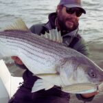
Striped Bass (Marine Waters)
28" to 31" Slot Limit
1 fish
Porgy (Scup) - Shore Anglers
9.5 inches
30 fish
Bluefish
No minimum size
3 fish
Weakfish
16 inches
1 fish
Pro Tip: When measuring fluke, the carcass with the dark side completely intact must be retained for inspection of the size limit. Do not fillet your catch in a way that prevents a DEC officer from verifying the total length.
5. REGIONAL ALTERNATIVE
Backup Plan: Shirley Chisholm State Park (Penn Pier)
If Canarsie Pier is overcrowded, or if a stiff southerly wind makes holding bottom impossible, your premium fallback location is just a short drive away at Shirley Chisholm State Park. Specifically, head to Penn Pier. Built on a reclaimed landfill, this pristine state park offers phenomenal, elevated access to Jamaica Bay's northern shore.
Penn Pier extends into slightly different current breaks than Canarsie, often holding massive schools of baitfish in its geometric corners. The target species remain exactly the same—fluke, bluefish, and porgy—but the pressure from other anglers is typically much lighter. The tactical approach here requires slightly heavier tackle; upgrade your bucktails to 1 oz or 1.5 oz to deal with the deeper water and faster current sweeps found directly off the end of the pier. Keep in mind that Shirley Chisholm State Park operates strictly under catch-and-release rules for certain areas, so verify the specific park guidelines at the entrance kiosk before harvesting any fish.
Whether you are bouncing bucktails for doormat fluke or casting metals into breaking bluefish, the urban estuary of Jamaica Bay offers world-class angling right in the shadow of the New York skyline. Respect the resource, pack out your trash, and fish hard.
Tight lines!
Editor's Choice: Must-Have Gear
FISHINGSIR Next-Gen Waterproof Chest Waders
★★★★★4.4 (7,370+ reviews)
2-Ply Tech: Upgraded nylon with 2.5x higher density than standard fabrics.
100% Waterproof: Lab-approved intrusion resistance with taped visible seams.
Ultra-Lightweight: Designed for all-day comfort while hunting or fishing.
As an Amazon Associate I earn from qualifying purchases. #ad
Loading forecast...
Live Fishing Conditions: Tides, Weather & Waves
Get real‑time tides, marine weather, swell and solunar activity for each spot so you know exactly when conditions line up for your best chance at a bite.
🎣
Canarsie Pier
Loading coordinates...
🌤️
WEATHER CONDITIONS
--°F
--°C
Loading...
🌡️
Feels Like--°F--°C
💧
Humidity--%
💨
Wind-- mph-- km/h
🧭
Direction--
📊
Pressure-- inHg-- hPa
☀️
UV Index--
🌊
MARINE CONDITIONS
🌊Wave Height
-- ft
-- m
Loading...
🧭Wave Direction
--°
Loading...
⏱️Wave Period
-- s
Loading...
📈Tide Status
-- ft
-- m
Loading...
🌙
LUNAR & SOLUNAR
🌕
Loading...
Illumination: --%
Major Period--:-- - --:----:-- - --:--
Minor Period--:-- - --:----:-- - --:--
🌅Sunrise--:--
🌇Sunset--:--
📅
24-HOUR FORECAST
Loading fishing conditions...
Fishing Spots Map
🎣
Book a Fishing Charter near Canarsie Pier Fishing Report Today 🎣
Local guides & charters. Verified captains, instant booking, best price guaranteed.
There was an error loading the map. Please try refreshing the page.
Info
Local Access & Facilities
Canarsie Pier serves as a critical junction where the concrete density of New York City meets the fertile, salt-washed expanse of Jamaica Bay. Part of the massive Gateway National Recreation Area, this location offers a fishing experience that is distinctly urban yet surprisingly productive. For the serious angler, this isn't just a city pier; it is a gateway to over 27,000 acres of diverse aquatic environments, ranging from deep channels to salt marshes. The atmosphere here is a unique collision of maritime history and metropolitan energy, situated near the historic Floyd Bennett Field. While the skyline is always visible, the water here holds the promise of significant saltwater game, drawing seasoned locals who know how to work the tides in this complex estuarine system.
The fishery here is defined by its accessibility and its exposure to the Atlantic influence pushing into the harbor. Unlike manicured resort marinas, this is a working recreation area where aviation history and angling culture intersect. The vibe is rugged and functional, catering to those who are self-sufficient and understand the logistical demands of fishing within one of the world's busiest cities. Whether you are launching a vessel to patrol the channels of Jamaica Bay or setting up for a long soak from the rail, success here requires navigating not just the water, but the unique infrastructure of the National Park Service (NPS) units that manage this coastline.
Experienced captains know that Canarsie Pier and the surrounding Gateway units act as a funnel for migratory species moving in and out of the harbor. The bottom topography varies significantly across the bay, requiring precise knowledge of the channels. While the area is open to the public, the sheer scale of the Gateway National Recreation Area—spanning from Sandy Hook to Breezy Point—means that local knowledge of specific access points and facility limitations is the difference between a productive outing and a logistical headache.
Access & Getting There
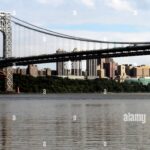
Reaching Canarsie Pier and the adjacent Floyd Bennett Field requires a strategic approach to navigating Brooklyn traffic. The primary artery for vehicular access is the Belt Parkway. Seasoned anglers know that timing your arrival is not just about the tide, but about beating the notorious congestion on this highway. The most direct route for those towing trailers or carrying heavy gear is via Exit 11S (Flatbush Avenue South). This route leads you directly toward the Marine Parkway Bridge; making a left at the last traffic light before the toll plaza puts you into the main entrance of Floyd Bennett Field, a central hub for the area's recreational logistics.
💡 Captain's Tip: Beat the Belt Parkway
The Belt Parkway is infamous for congestion. Local pros plan their transit to arrive before 6:00 AM or after 8:00 PM to avoid gridlock. If you are towing a boat, be hyper-aware of bridge height restrictions on connecting parkways in the NY metro area; stick to designated truck/trailer routes where possible.
For boaters, the launch situation within the Gateway National Recreation Area is functional but requires patience. The boat access points are managed by the NPS, and while they are generally well-maintained, they can become choke points during peak summer weekends. The ramps are designed to handle the tidal fluctuations of Jamaica Bay, but low tide can expose slick, mud-covered lower sections. It is advisable to inspect the ramp conditions at the Ryan Visitor Center area before committing to a launch, especially if you are hauling a deeper draft vessel. The wind is a major factor here; the bay is relatively protected, but a strong southerly wind can stack chop against the outgoing tide, making recovery at the ramp challenging.
Parking is a critical logistical component in this urban fishery. Unlike remote spots where you can park on the verge, enforcement here is strict. The Floyd Bennett Field area offers paved driveway surfaces for camping and recreation, but day-use parking fills rapidly. The Ryan Visitor Center (located at 5031 Flatbush Avenue) is the best initial stop for orientation and parking permits if required. For those looking for off-site parking or long-term storage, commercial lots like SmartPark JFK are available but are located over 4 miles away, making them impractical for day-of trailer storage. Stick to the official NPS lots designated for boaters and anglers to ensure vehicle security.
Canarsie Pier Pre-Trip Checklist
Facilities & Amenities
The infrastructure around Canarsie Pier is a mix of federal recreation facilities and distant commercial amenities. It is vital to understand that while the National Park Service provides excellent access and camping facilities, the immediate area is a "resource desert" for specific fishing supplies. There is no tackle shop directly on the pier or within the immediate park gates. The nearest reliable provisioning centers are significant distances away. For example, Lucky’s Bait & Tackle is approximately 11.8 miles away on Staten Island, and Magnolia Pier Bait & Tackle is roughly 11.5 miles east in Long Beach. This logistical reality dictates that you must be fully stocked with bait, ice, and terminal tackle before you exit the highway.
💡 Captain's Tip: The "No-Go" Supply Zone
Do not expect to find fuel or ice at the boat ramp. The nearest marine amenities are often miles away in heavy traffic. Fill your tanks and coolers on the highway before you enter the Flatbush Avenue corridor to avoid burning valuable fishing time.
One of the most unique features of this location is the presence of Camp Gateway within Floyd Bennett Field. This is one of the few places in the world where you can camp legally within a major metropolis. The campground offers both RV (non-electric) and tent sites. This allows for a "dawn patrol" strategy that is otherwise impossible for anglers commuting from the suburbs. Sites like A50 and A45 offer paved driveways suitable for RVs up to 50 feet (check specific site lengths), while tent loops like Tamarack and Wiley Post B provide a more rustic experience. The campground includes flush toilets and showers seasonally, making it a viable basecamp for a multi-day fishing expedition.
The table below details key facilities and their proximity to the main fishing grounds. Note the distances, as "nearby" in New York City can translate to 45 minutes of driving.
Facility Name
Type
Distance
Details / Specialization
Camp Gateway - Brooklyn
Campground
2.5 miles
Located at Floyd Bennett Field. RV & Tent sites. Rare urban camping opportunity.
Ryan Visitor Center
Info / Permits
3.0 miles
Ranger desk, maps, and park orientation. Historic aviation terminal.
SmartPark JFK
Parking
4.1 miles
24-hour access. Useful for overflow or non-trailer vehicle storage.
Lucky’s Bait & Tackle
Bait Shop
11.8 miles
Nearest full-service shop. Located on Staten Island.
Gina Ann Fishing Charters
Charter Fleet
16.2 miles
Based in Freeport. High-rated local captain for offshore/inshore trips.
Accommodations outside of the campground are standard urban fare, but generally removed from the immediate waterfront. If camping isn't your preference, look for lodging towards Queens or Brooklyn centers, though this adds commute time. For those seeking a guided experience, the local charter fleet is not centered at Canarsie itself. You will likely need to travel to Freeport or Port Washington to link up with top-tier operations like Gina Ann Fishing Charters or Long Island Fishing Charters. These fleets are known for targeting the seasonal runs of striped bass and bluefish that the region is famous for.
Permits, Regulations & Fees
Navigating the regulatory landscape here is as important as navigating the channels. Canarsie Pier and Jamaica Bay fall under the jurisdiction of the Gateway National Recreation Area, meaning federal rules apply in addition to New York State regulations. While a general saltwater fishing registry is required by New York State (the registry is free but mandatory), the NPS may have specific restrictions regarding access hours and parking permits for anglers. The Ryan Visitor Center is your primary checkpoint for current "Kapu" (restrictions) or closures, particularly regarding sensitive marshland restoration areas.
Conservation is a major focus in Jamaica Bay. The area serves as a critical nursery for marine life and a sanctuary for migratory birds. Anglers should be particularly aware of "No Wake" zones and restricted areas near the Jamaica Bay Wildlife Refuge. This is not just about avoiding fines; it is about respecting the ecological recovery of one of the most resilient urban estuaries on the planet. Special permits are often required for activities like archery or off-road beach access (where applicable in the wider Gateway area), so never assume that a general state license covers all activities.
💡 Captain's Tip: Verify Parking Permits
While fishing is generally open, parking at specific lots within Gateway National Recreation Area often requires a specific permit, especially for night fishing. Visit the Ryan Visitor Center immediately upon arrival to ensure your vehicle dashboard displays the correct pass to avoid federal tickets.
Events & Seasonal Information
The rhythm of Canarsie Pier and Jamaica Bay is dictated by the seasons. The fishery comes alive in the spring with the arrival of migratory striped bass, followed by bluefish and fluke in the warmer months. The "shoulder seasons" of late spring and early autumn are prime times for anglers, as the water temperatures in the bay are optimal. During the height of summer, the heat radiating from the city can shut down the bite by mid-morning, making pre-dawn starts essential. The Camp Gateway season runs from April through October, aligning perfectly with the most productive fishing months.
While specific tournament schedules fluctuate, the summer months often see increased recreational traffic due to general boating and family activities. The Ryan Visitor Center hosts various interpretive programs, and while these are often history or nature-focused, they can impact parking availability. The bay is also a popular spot for paddle sports; anglers operating powerboats should be vigilant for kayaks and paddleboards, particularly in the narrow channels winding through the marsh grass.
Contact Information & Resources
For the most accurate and up-to-date information, direct communication with the managing agencies is recommended. The Gateway National Recreation Area headquarters can be reached at (718) 354-4606. For specific inquiries regarding the Camp Gateway campground at Floyd Bennett Field, contact the ranger station at 718-338-3799. In case of emergency on the water, the U.S. Coast Guard maintains a strong presence in New York Harbor, but self-reliance is key. Ensure your VHF radio is functional, as cell service can be surprisingly spotty in the marsh channels despite the proximity to the city.
For precise locations, real-time wind conditions, and detailed maps of the boat ramps and camping loops mentioned above, consult the live dashboard and interactive widgets below.
Our spot reports combine data-driven forecasts with curated local information. The forecast is generated by our proprietary Fishing Score algorithm (0–100%), which analyzes real-time data from Open-Meteo API, validated against NOAA CO-OPS tide gauges and USGS water-monitoring stations. The model weights tide dynamics (35%), wave energy (25%), wind patterns (20%) and time of day (20%)—factors shown to influence fish feeding behavior through marine-biology research and decades of charter log data.
Access, facilities and services information for each fishing spot is sourced from official datasets such as Recreation.gov (RIDB), state park & wildlife agencies, and geospatial providers like Google Maps. These sections undergo scheduled re-validation every 3–6 months to ensure that boat ramps, park access, contact details and local services remain accurate.
Narrative sections (catches, seasonal behavior, local tips) are synthesized from these data sources and refined following the Fishing Reports Today editorial guidelines, combining bibliographic research from ichthyology and oceanography with expert angler experience. Our team reviews reports on a regular basis, while the forecast model itself updates every 6 hours for real-time accuracy.
⚠️ Important: Always verify current local regulations, access restrictions and weather conditions before fishing. These reports are intended as a planning aid, not a guarantee of catches or safety. When in doubt, contact local authorities or park managers listed on the page.
To provide the best experiences, we use technologies like cookies to store and/or access device information. Consenting to these technologies will allow us to process data such as browsing behavior or unique IDs on this site. Not consenting or withdrawing consent, may adversely affect certain features and functions.
Functional Always active
The technical storage or access is strictly necessary for the legitimate purpose of enabling the use of a specific service explicitly requested by the subscriber or user, or for the sole purpose of carrying out the transmission of a communication over an electronic communications network.
Preferences
The technical storage or access is necessary for the legitimate purpose of storing preferences that are not requested by the subscriber or user.
Statistics
The technical storage or access that is used exclusively for statistical purposes.The technical storage or access that is used exclusively for anonymous statistical purposes. Without a subpoena, voluntary compliance on the part of your Internet Service Provider, or additional records from a third party, information stored or retrieved for this purpose alone cannot usually be used to identify you.
Marketing & Affiliates
The technical storage or access is required to create user profiles to send advertising, or to track the user on a website or across several websites for similar marketing purposes, including affiliate tracking for products recommended in our reports.


Leave a Reply