Summer angling conditions are in full effect along the Palisades in Fort Lee, making this an excellent time to hit the water. However, the Hudson River is a massive, dynamic tidal estuary that demands respect. The verdict is a solid "GO," but caution is mandatory due to the intense summer boat traffic and powerful river currents.
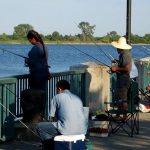
The area directly beneath the George Washington Bridge acts as a geographical funnel for tidal flow. During the peak of the ebb (outgoing) tide, the current can be incredibly swift. When a strong southerly summer breeze opposes this outgoing tide, it creates steep, tightly packed waves that can be hazardous for kayaks and small aluminum boats. Shoreline anglers operating near the Ross Dock Picnic Area or the Hazard's Ramp seawalls must remain vigilant. Large commercial barges and high-speed recreational cruisers frequently pass through this deep-water channel, throwing massive wakes that can easily sweep over the lower retaining walls and riprap. Always keep an eye on the horizon, wear sturdy footwear with gripping soles to navigate the slick, algae-covered rocks, and consult a reliable tidal chart before planning your trip.
From the editor
Tired of fishing with strangers you can’t trust?
Nautrek is the first social network for serious anglers — verified partners, real trips, cost splitting and intel sharing without burning your spots. Private beta now open.
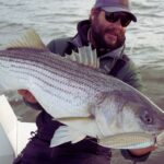
While the legendary spring spawning run has concluded and the massive breeders have migrated out to the Atlantic Ocean, the Fort Lee stretch remains a highly productive zone for resident summer Striped Bass. These schoolie-sized fish, generally ranging from 18 to 26 inches, are actively feeding along the shadow lines and structure. You may also encounter the occasional larger holdover bass lurking in the deeper, cooler channels where the water temperatures remain stable.
Sleeper Pick: Channel Catfish and White Perch
Most anglers obsess over Striped Bass and completely ignore the phenomenal bottom fishery that peaks during the summer months. Channel Catfish and White Catfish are incredibly abundant in this stretch of the Hudson. They are aggressive, put up a fantastic fight on medium tackle, and are highly active during the dog days of summer. Additionally, White Perch school up tightly along the rocky banks and provide non-stop action for light-tackle enthusiasts.
Baitfish Report:
The river is currently teeming with forage. Adult Atlantic Menhaden (bunker) are moving through the channel, while juvenile river herring and peanut bunker can be seen dimpling the surface in the quieter shoreline eddies. Down on the bottom, the muddy substrates are loaded with bloodworms, sandworms, and blue crabs. Matching this forage is the key to unlocking the summer bite.
3. TACTICAL STRATEGY
Where to Deploy
Location is everything on the Hudson. The most productive shoreline structure in Fort Lee is the stretch from the Ross Dock Picnic Area heading south toward the George Washington Bridge stanchions. The bathymetry here is dramatic; the riverbed drops off rapidly from the rocky shoreline into 20 to 30 feet of water. Focus your efforts on the current seams—the visible lines on the surface where the fast-moving main river current rubs against the slower-moving water near the shore. Fish use these seams as conveyor belts to ambush baitfish being swept downriver.
Lure Selection and Color
Because of the deep water and fast current, you must use heavy artificials to reach the strike zone. A 1.5oz to 2oz bucktail jig is the ultimate weapon here. Opt for white or chartreuse colors, as the Hudson's water clarity is often stained with a greenish-brown tint. Tip your bucktail with a 4-inch white curly tail grub or a synthetic strip bait for added action. If you are fishing vertically from a boat near the bridge pilings, a Rapala Jigging Rap in size #9 (Chrome Blue or Silver) is incredibly effective for triggering reaction strikes from bass holding tight to the concrete structure.
Pro Tip: If you notice Striped Bass swirling on the surface at dawn but they refuse your sub-surface jigs, switch immediately to a topwater pencil popper. Work it aggressively with a walk-the-dog cadence to mimic a wounded bunker fleeing the scene. The explosive surface strikes in the shadow of the bridge are unforgettable.
Bait Strategies and Rigging
For bait fishermen, fresh chunked bunker is the undisputed champion for both Striped Bass and large Channel Catfish. Rig your chunks on a standard fish-finder slide to allow the fish to take the bait without feeling the weight of the sinker. You will need a heavy 3oz to 5oz pyramid sinker to hold bottom in this current. Use a short 18-inch fluorocarbon leader (40lb test) to prevent your bait from spinning and tangling in the heavy flow.
Pro Tip: When targeting the sleeper White Perch or summer catfish, downsize your gear. A simple high-low rig tied with 15lb fluorocarbon, armed with #4 baitholder hooks and baited with fresh bloodworms or nightcrawlers, will keep your rod bent all day when fished right off the Ross Dock retaining wall.
Timing the Bite
Tidal movement dictates feeding behavior. The absolute best bite window occurs during the last two hours of the incoming tide and the first hour of the outgoing tide. During this phase, the water is moving, but the current is manageable enough to keep your bait in the strike zone. Combine this tidal window with dawn or dusk, and your chances of success skyrocket. The summer sun pushes fish into the deep channel during midday, making low-light periods critical for shoreline anglers.
4. REGULATIONS SNAPSHOT
Compliance is critical. All anglers 16 and older must be registered with the free New Jersey Saltwater Recreational Registry Program before casting a line. Below are the essential summer regulations for the target species in this region:
Target Species
Size Limit
Bag Limit
Important Notes
Striped Bass
28 inches to less than 31 inches
1 fish per angler
Strict slot limit. Non-offset circle hooks are mandatory when fishing with bait to reduce release mortality.
Bluefish
No minimum size
5 fish (shore/private vessel)
Charter and for-hire vessel patrons are permitted 7 fish per day.
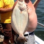
Summer Flounder (Fluke)
18 inches
3 fish per angler
Applies to general New Jersey marine waters.
5. REGIONAL ALTERNATIVE
If the Hudson River is blown out by heavy winds, rendered unfishable by massive boat wakes, or you simply want a change of pace, you do not have to travel far for excellent fishing. Your primary backup plan should be Overpeck Creek in nearby Leonia, or the adjacent Hackensack River.
Overpeck Creek provides a highly sheltered, calm-water environment with fantastic public access parks. This area is a haven for freshwater and brackish species. Leave the heavy surf gear in the truck and switch to a medium-light spinning setup. Target species in the Overpeck Creek system include:
Largemouth Bass: Target the shoreline weed beds and submerged timber. A 1/4oz weedless jig or a classic wacky-rigged Senko worm in green pumpkin or black-and-blue will produce aggressive strikes from fish hiding in the shade.
Black Crappie: Suspend small live minnows or 1/16oz marabou jigs under a slip bobber near submerged branches and dock pilings.
Common Carp: Chum the shallow muddy flats with sweet corn and use a specialized hair rig for these heavyweight fighters.
It is a peaceful, highly productive alternative when the mighty Hudson is too aggressive to fish comfortably.
Pro Tip: When fishing the rocky banks of the Hudson River at Fort Lee, always pack double the amount of terminal tackle (sinkers, hooks, and pre-tied rigs) you think you will need. The jagged riprap, submerged bridge debris, and old pilings are notorious tackle graveyards. Expect to lose a few rigs to the river gods, and re-tie often to check your leader for abrasions.
Tight lines!
Editor's Choice: Must-Have Gear
FISHINGSIR Next-Gen Waterproof Chest Waders
★★★★★4.4 (7,370+ reviews)
2-Ply Tech: Upgraded nylon with 2.5x higher density than standard fabrics.
100% Waterproof: Lab-approved intrusion resistance with taped visible seams.
Ultra-Lightweight: Designed for all-day comfort while hunting or fishing.
As an Amazon Associate I earn from qualifying purchases. #ad
Loading forecast...
Live Fishing Conditions: Tides, Weather & Waves
Get real‑time tides, marine weather, swell and solunar activity for each spot so you know exactly when conditions line up for your best chance at a bite.
🎣
Hudson River, Fort Lee, NJ
Loading coordinates...
🌤️
WEATHER CONDITIONS
--°F
--°C
Loading...
🌡️
Feels Like--°F--°C
💧
Humidity--%
💨
Wind-- mph-- km/h
🧭
Direction--
📊
Pressure-- inHg-- hPa
☀️
UV Index--
🌊
MARINE CONDITIONS
🌊Wave Height
-- ft
-- m
Loading...
🧭Wave Direction
--°
Loading...
⏱️Wave Period
-- s
Loading...
📈Tide Status
-- ft
-- m
Loading...
🌙
LUNAR & SOLUNAR
🌕
Loading...
Illumination: --%
Major Period--:-- - --:----:-- - --:--
Minor Period--:-- - --:----:-- - --:--
🌅Sunrise--:--
🌇Sunset--:--
📅
24-HOUR FORECAST
Loading fishing conditions...
Fishing Spots Map
🎣
Book a Fishing Charter near Hudson River, Fort Lee, NJ Fishing Report Today 🎣
Local guides & charters. Verified captains, instant booking, best price guaranteed.
There was an error loading the map. Please try refreshing the page.
Info
Local Access & Facilities
Fishing the Shadow of the Palisades
The Hudson River along the Fort Lee, New Jersey shoreline offers a fishery defined by dramatic contrasts. To the west, the ancient basalt cliffs of the Palisades rise steeply, creating a windbreak and a stunning visual backdrop; to the east, the urban sprawl of Manhattan dominates the horizon. For the expert angler, this section of the river—located roughly at 40.85° N, 73.96° W—presents a complex hydrological environment where deep channel currents collide with structure, creating prime holding grounds for migratory striped bass and bluefish. The water here is dynamic, heavily influenced by the tidal push from the Atlantic and the freshwater discharge from the north.
This is not a manicured resort fishery; it is an industrial and historic waterway that demands respect and navigational competence. The vibe is gritty and purposeful, frequented by serious captains who know how to play the tides around the George Washington Bridge pilings. While the shoreline offers pockets of serenity near historic sites, the main channel is a working highway for barges and tugs. Anglers targeting this zone must be comfortable maneuvering in heavy traffic and reading water that can shift from glass-calm to choppy confusion when the wind opposes the strong tidal flow.
Success in Fort Lee requires logistical precision. Unlike the dedicated fishing towns of the Jersey Shore or Montauk, this area lacks a centralized "fisherman’s wharf" atmosphere. You are fishing on the edge of a metropolis, meaning shore access is prized and boat ramps are functional rather than luxurious. The primary draw here is the seasonal run of game fish that funnel through this narrow stretch of the Hudson, using the structure and current breaks as ambush points. It is a fishery that rewards the prepared tactician who brings their own gear, bait, and local knowledge.
💡 Captain's Tip: Current Awareness
The Hudson River current near the George Washington Bridge is deceptively powerful. When the tide turns, the water moves with significant velocity. Ensure your trolling motor batteries are fully charged and your anchor rode is sufficient for depths exceeding 40 feet in the main channel.
Access & Getting There
Reaching the Fort Lee waterfront involves navigating some of the most congested roadways in the Northeast. The primary arteries are Interstate 95 and the Palisades Interstate Parkway. Seasoned locals know that timing is everything; attempting to tow a boat through the bridge approaches during rush hour is a recipe for frustration. The best strategy is a "dawn patrol" approach, hitting the road well before 5:00 AM to beat the commuter crush that inevitably builds on the approach to the George Washington Bridge.
The boat launch situation in this specific sector requires careful planning. The data indicates specific access coordinates near 40.85° N and 40.86° N, but these are often municipal or park-managed ramps that may lack the expansive infrastructure of coastal marinas. The ramps here can be steep, and during low tide, the drop-off at the end of the concrete can be severe. It is imperative to check the tide charts before launching or retrieving. A low-tide retrieval on a slick, algae-covered ramp with a heavy current sweeping sideways can test even the most experienced trailer driver.
Weather contingencies are critical in this corridor. The Palisades provide excellent shelter from westerly winds, creating a calm lane along the Jersey side even when the rest of the region is blowing hard. However, a strong north or south wind will funnel down the river valley. If the wind opposes the tide—specifically a south wind against an outgoing tide—the river can stack up into short, steep chop that is punishing for small skiffs. In these conditions, sticking close to the shoreline structure or shifting to the leeward side of bridge pilings is the only viable option.
Parking is the most significant logistical hurdle in Fort Lee. The available data highlights that street parking in the vicinity of nearby landmarks like the Hamilton Grange National Memorial is "very limited." For boaters, trailer parking is at a premium. Unlike the sprawling lots found at shore points, the lots here are often shared with park visitors and commuters. Security is generally decent due to the high visibility of public parks, but leaving gear exposed in the bed of a truck is never advisable in an urban interface zone.
💡 Captain's Tip: Launch Logistics
Because trailer parking is scarce and local streets are tight, have a "load and go" system ready. Prep your boat in the staging lane—straps off, plug in, gear loaded—before you hit the ramp. Lingering on the ramp to load coolers will cause gridlock and draw the ire of local regulars.
Hudson River, Fort Lee, NJ Pre-Trip Checklist
Facilities & Amenities
The infrastructure surrounding the Fort Lee fishing grounds is distinctively urban, meaning you will find plenty of convenience stores but very few specialized marine amenities immediately at the water's edge. The data indicates a significant gap in immediate bait and tackle availability. The nearest listed bait sources, such as In N’ Out Smoke Shop in Paterson (12.6 miles away) or Lucky’s Bait & Tackle in Staten Island (20.4 miles away), are substantial drives from the launch. This is a critical piece of "negative knowledge": do not arrive at the ramp expecting to buy live eels or fresh bunker. You must procure all bait and terminal tackle the day before or en route.
The charter fleet servicing this area does not typically dock in Fort Lee itself. Operators like RockFish Charters (Howard Beach, 15.2 miles) and Gypsea Fishing Charters (Brooklyn, 18 miles) run trips that may reach into the lower Hudson or surrounding bays, but they are based in the outer boroughs or Long Island. For the visiting angler, this means there is no local "dock talk" hub where you can walk up and ask a mate what's biting. You are largely on your own for real-time intelligence unless you are plugged into the local radio channels.
In terms of missing amenities, be aware that fuel docks are virtually non-existent on this immediate stretch of the Jersey side. Plan your fuel consumption carefully. If you are running a center console, fill up at a highway gas station before launching. The lack of a local marina fuel pump means that running dry on the river will result in a long, expensive tow from a commercial salvage operator. Similarly, ice is a commodity you should buy in bulk at a grocery store on the highway, as the immediate ramp areas often lack high-capacity ice vendors.
Lodging options are plentiful but generally cater to NYC tourists rather than anglers with boats. Listings like Camp Kinderland or scout camps are not suitable for transient anglers. For those towing boats, look for hotels along the Route 4 or Route 46 corridors west of Fort Lee, where parking lots are larger and surveillance is better. Avoid trying to park a trailer at hotels in the dense urban core or immediately adjacent to the bridge.
Facility Name
Type
Distance
Notes
In N’ Out Smoke Shop
Bait/Supplies
12.6 miles
Nearest bait source; Plan ahead.
RockFish Charters
Charter Fleet
15.2 miles
Based in Howard Beach; High rating (4.9).
The Parking Spot Haynes
Parking
15.7 miles
Airport parking; Not suitable for daily trailer use.
Hamilton Grange Visitor Center
Info/Restrooms
2.2 miles
Good for area orientation and maps.
Permits, Regulations & Fees
Navigating the regulatory landscape here is as complex as the currents. Because the Hudson River forms the border between New Jersey and New York, jurisdictional boundaries can be tricky. While the boat launch may be in New Jersey (Fort Lee), the channel markers often delineate the state line. Anglers should possess a valid fishing registration for the state they are launching from, but it is prudent to understand the reciprocity rules for the Hudson River. The State Fishing Agency manages the regulations, and strict size and bag limits for striped bass are enforced to protect the spawning stock.
Protected zones in this area are largely cultural and historical. The Hamilton Grange National Memorial and General Grant National Memorial are federally managed sites nearby. While these are primarily land-based attractions, the waters adjacent to parks and monuments may have specific restrictions regarding anchoring or beaching vessels. Respecting these "Kapu" (restricted) zones is essential not only for legal compliance but to maintain the relationship between the angling community and the National Park Service.
There is no specific "fishing permit" required to access the water itself, but parking fees at municipal ramps or adjacent lots are standard. These are often automated kiosks or app-based payment systems. Bring a credit card and a smartphone, as cash drop-boxes are becoming obsolete. Additionally, be mindful of the commercial traffic lanes. Anchoring in the navigable channel is a federal offense and creates a severe safety hazard. The Coast Guard and Harbor Police patrol this sector aggressively to ensure the safety of commercial transit.
Events & Seasonal Information
The rhythm of the Hudson River fishery is dictated by the migration of anadromous fish. The spring run, typically peaking from April through early June, sees the arrival of large striped bass moving upriver to spawn. This is the "main event" for local anglers. During this window, the river comes alive with boats drifting live bait or trolling tube and worm rigs. The fall run offers a second, often more aggressive bite as fish exit the estuaries to head south for the winter.
Summer in Fort Lee is characterized by slower fishing during the heat of the day and increased recreational boat traffic. The "dawn patrol" becomes essential during July and August, not just to beat the traffic on the GWB, but to capitalize on the bite before the sun drives the fish deep. The trade-off is the wind; summer afternoons often bring a stiff southerly breeze that bucks the outgoing tide, creating the choppy conditions mentioned earlier.
While there are no major professional tournaments hosted directly at the Fort Lee ramps, the area is part of the broader NY/NJ striped bass tournament circuit. Local clubs often hold seasonal derbies. Anglers should also be aware of non-fishing events, such as fleet weeks or fireworks displays, which can result in temporary security zones and river closures enforced by the Coast Guard. Checking the "Local Alerts" before hitching up the boat is standard procedure for the Hudson River regular.
💡 Captain's Tip: Seasonal Debris
During the spring thaw or after heavy rain events, the Hudson carries massive amounts of floating debris—whole trees, railroad ties, and pallets. Navigate with extreme caution, especially when running on plane in low light. A submerged log can take out a lower unit instantly.
Contact Information & Resources
For official information regarding park access, shoreline closures, and historical site hours, the National Park Service is the primary point of contact. The Hamilton Grange National Memorial can be reached at (646) 494-5366, and the General Grant National Memorial visitor center is available at (646) 670-7251. These offices can provide up-to-date information on parking availability and any special events that might impact access to the waterfront parks.
In terms of safety, self-reliance is key. While the Coast Guard is active in the harbor, response times can vary. Ensure you have a working VHF radio monitoring Channel 16. For non-emergency assistance or towing, you will likely be relying on commercial providers based out of nearby harbors in NY or NJ. Always file a float plan with a contact on land, detailing your launch point and expected return time, as cell service can be spotty directly under the cliffs of the Palisades.
For precise locations of the unnamed boat ramps, real-time wind conditions, and the exact boundaries of the state lines, consult the live dashboard and interactive maps below.
Our spot reports combine data-driven forecasts with curated local information. The forecast is generated by our proprietary Fishing Score algorithm (0–100%), which analyzes real-time data from Open-Meteo API, validated against NOAA CO-OPS tide gauges and USGS water-monitoring stations. The model weights tide dynamics (35%), wave energy (25%), wind patterns (20%) and time of day (20%)—factors shown to influence fish feeding behavior through marine-biology research and decades of charter log data.
Access, facilities and services information for each fishing spot is sourced from official datasets such as Recreation.gov (RIDB), state park & wildlife agencies, and geospatial providers like Google Maps. These sections undergo scheduled re-validation every 3–6 months to ensure that boat ramps, park access, contact details and local services remain accurate.
Narrative sections (catches, seasonal behavior, local tips) are synthesized from these data sources and refined following the Fishing Reports Today editorial guidelines, combining bibliographic research from ichthyology and oceanography with expert angler experience. Our team reviews reports on a regular basis, while the forecast model itself updates every 6 hours for real-time accuracy.
⚠️ Important: Always verify current local regulations, access restrictions and weather conditions before fishing. These reports are intended as a planning aid, not a guarantee of catches or safety. When in doubt, contact local authorities or park managers listed on the page.
To provide the best experiences, we use technologies like cookies to store and/or access device information. Consenting to these technologies will allow us to process data such as browsing behavior or unique IDs on this site. Not consenting or withdrawing consent, may adversely affect certain features and functions.
Functional Always active
The technical storage or access is strictly necessary for the legitimate purpose of enabling the use of a specific service explicitly requested by the subscriber or user, or for the sole purpose of carrying out the transmission of a communication over an electronic communications network.
Preferences
The technical storage or access is necessary for the legitimate purpose of storing preferences that are not requested by the subscriber or user.
Statistics
The technical storage or access that is used exclusively for statistical purposes.The technical storage or access that is used exclusively for anonymous statistical purposes. Without a subpoena, voluntary compliance on the part of your Internet Service Provider, or additional records from a third party, information stored or retrieved for this purpose alone cannot usually be used to identify you.
Marketing & Affiliates
The technical storage or access is required to create user profiles to send advertising, or to track the user on a website or across several websites for similar marketing purposes, including affiliate tracking for products recommended in our reports.


Leave a Reply