❄️ Raritan Bay & Highlands Fishing Report: Winter's Grip & The Perch Patrol
Region: Perth Amboy to Atlantic Highlands, NJ
Report Date: February 10, 2026
Utility Score: 10/10
The hardwater season has descended upon the Raritan Bay complex with a vengeance. Recent reports confirm significant ice buildup in the marinas from Keansburg to Atlantic Highlands, making boat operations challenging. While the open bay is largely quiet due to closed seasons and frigid temps, the biological data indicates specific pockets of life for the dedicated angler. The headline right now is White Perch in the brackish tributaries and a "last call" for Tautog on the oceanfront before the season closes.
1. GO/NO-GO STATUS
VERDICT: CAUTION / RESTRICTED
- Ice Conditions: Skim ice is present in Atlantic Highlands Yacht Harbor and heavy ice flows are reported in the upper Raritan River. Marina access may be blocked.
- Wind/Weather: Frigid temperatures have locked up backwater coves. Open bay fishing is only viable on calm days for vessels capable of breaking thin harbor ice.
- Safety Advisory: Do not attempt to walk on salt ice in the bay—it is porous and unstable. Stick to verified safe freshwater ice or open water banks.
2. SPECIES INTEL (Bio-Verified)
Based on citizen science observations from Jan 11–Feb 10, 2026, here is what is actually swimming in our local waters:
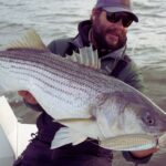
🏆 Primary Target: White Perch & "Ray-finned Fishes"
Bio-Source: Ray-finned Fishes (Feb 5, New Brunswick), White Sucker (Jan 11, Marlboro)
While the "Ray-finned Fish" observation in New Brunswick is generic, in February, this almost exclusively correlates to the White Perch overwintering schools or Carp in the upper Raritan. These fish stack up in deep holes in brackish water, becoming the most reliable game in town when the bay is shut down.
🎣 The Sleeper Pick: Tautog (Blackfish)
Bio-Source: Tautog (Feb 5, Regional)
With the season open until February 28, Tautog are the only heavy-hitter available for saltwater anglers. The catch data confirms they are active, but you must look to the ocean reefs (Sandy Hook Reef, Shrewsbury Rocks), not the bay.
🐟 Forage Report (Match the Hatch)
Bio-Source: Naked Goby (Atlantic Highlands), Inland Silverside (Atlantic Highlands), American Gizzard Shad (Regional)
The presence of Silversides and Gobies inside the Atlantic Highlands harbor (observed Jan 11-12) is critical intel. Any holdover predatory fish will be keying in on small, slender profiles.
Pro Tip: Downsize your presentations. If you are targeting holdover Stripers (catch & release only in the ocean) or Perch, use 2-3 inch slim profiles to mimic these silversides.
3. TACTICAL STRATEGY
Scenario A: The Brackish Bank Game (White Perch)
- Where: Raritan River near the Edison/New Brunswick bridges and the Sayreville marsh banks. Look for the "warm" water pockets or deep scour holes near bridge pilings (15-20ft depth).
- The Rig: High-low bottom rig with #4 or #6 Baitholder hooks.
- Bait: Grass Shrimp is king. If unavailable, small pieces of Bloodworm are the standard.
- Artificial Option: 1/16oz or 1/32oz jig heads tipped with a 2-inch white or chartreuse grub. Work it painfully slow along the bottom.
- Timing: The last two hours of the outgoing tide concentrate these fish in the deeper channels.
Scenario B: Ocean Tautog (Boat Only)
- Where: Sandy Hook Reef or Shrewsbury Rocks. You need to get out of the bay. Depths of 45-65ft are producing the best bites.
- The Jig: 1.5oz to 3oz Flat-Sided Jigs (Magictail or similar) in "Green Crab" or "Glow White" patterns.
- Bait: White Legger Crabs (halved) or Green Crabs. Use scissors to trim legs and expose the scent.
- Pro Tip: The bite is a "scratch." You will feel a tap-tap before the weight. Wait for the second solid thump before setting the hook.
4. REGULATIONS SNAPSHOT (Feb 2026)
| Species | Status (NJ) | Limits |
|---|
| Striped Bass | CLOSED in Bay/Rivers | Opens March 1. (Ocean 0-3mi open, 1 fish 28"-31") |
| Tautog | OPEN | 4 Fish, 15" Min (Closes Feb 28) |
| Winter Flounder | CLOSED | Opens March 1 |
| White Perch | OPEN | No Limit (Fresh/Brackish) |
5. REGIONAL ALTERNATIVE (Freshwater Fallback)
Location: Manalapan Lake or Big Brook Park (Marlboro)
If the wind is howling on the bay (20kts+), head inland. The bio-data confirms activity for Eastern Mudminnow, White Sucker, and Blacknose Dace in these areas. While these are baitfish, their activity signals that Pickerel and Panfish are active.
- Tactic: Use small live minnows under a float for Pickerel.
- Lure: 1/8oz inline spinners (Mepps/Rooster Tail) retrieved slowly near weed edges.
Tight lines and stay warm!
Get real‑time tides, marine weather, swell and solunar activity for each spot so you know exactly when conditions line up for your best chance at a bite.
The waters stretching from
Perth Amboy to
Atlantic Highlands represent one of the most dynamic and historically significant fisheries in the Northeast. This is not a pristine, silent wilderness; it is a rugged, industrial maritime theater where the
Raritan Bay meets the
New York Harbor, offering seasoned anglers a unique challenge against a backdrop of urban infrastructure. The area is defined by its strategic location near the
Verrazzano-Narrows Bridge, where powerful currents flush baitfish through the channels, creating prime ambush points for game fish.For the expert angler, this region offers a stark contrast between the heavy shipping traffic of the channel and the productive shoals along the coastline. The atmosphere here is electric, dominated by the visual magnitude of the bridge and the distant
Manhattan skyline. While the environment is heavily developed, the sub-surface topography is rich with structure. Anglers launching here are often targeting the dawn patrol window, looking to capitalize on the moving tides that scour the bridge pilings and the riprap along the shoreline before the commercial traffic peaks.Success in this corridor requires more than just good gear; it demands a logistical mastery of the urban environment. The interplay between New Jersey and New York waters means navigating a complex boundary line, while the physical access points are often gateways to historic fortifications like
Fort Wadsworth. Whether you are surf casting from the shadow of
Battery Weed or navigating the currents near
Staten Island, this fishery commands respect for both its heavy water and its heavy history.
Access & Getting There
Navigating to the
Perth Amboy and
Staten Island access points requires a strategic approach to traffic, particularly given the reliance on major arteries like the
New Jersey Turnpike and the
Verrazzano-Narrows Bridge. For anglers towing center consoles, the approach from
Brooklyn involves staying to the far right on the lower level of the bridge. If the lower level is closed, the upper level is the only option, but heavy crosswinds can make this a white-knuckle drive with a high-profile boat trailer. From
New Jersey, the
Outerbridge Crossing or
Goethal's Bridge leads into the
Staten Island Expressway, where the
Lily Pond Avenue exit is the critical gateway to the
Fort Wadsworth and
Camp Gateway areas.The primary boat access point identified in the official records is the
Gateway NRA-Staten Isl Boat Launch Parking. This facility serves as a crucial hub for launching into the
Narrows. While the ramps are generally serviceable, veteran captains know that the parking situation can be tight. The lot at
Camp Gateway Ranger Station (Building #220) is the check-in point. It is essential to arrive well before the mid-morning rush, as this area serves a dual purpose for recreational boaters and visitors to the historic sites.
💡 Captain's Tip: Bridge Logistics
When crossing the Verrazzano-Narrows Bridge with a trailer, always aim for the lower level to reduce windage. If approaching from New Jersey via the Outerbridge, monitor the Staten Island Expressway traffic; delays here can cost you the entire morning bite. Plan to be wheels-down at the ramp by 5:00 AM to beat the commuter crush.
Weather contingencies are paramount in this sector. The
New York Harbor acts as a massive funnel. When the wind opposes the tide, particularly a strong south wind against an outgoing tide, the waters near the bridge and the mouth of the bay can stack up into confused, dangerous seas. In these conditions, utilizing the leeward protection of the
Staten Island shoreline or retreating into the
Raritan Bay closer to
Perth Amboy is the prudent move. Parking at the
Gateway NRA is generally secure, but standard urban precautions apply: lock the trailer tongue and remove extensive electronics from the dash if leaving the rig overnight.
Facilities & Amenities
The infrastructure supporting this fishery is a mix of federal recreation facilities and gritty, reliable local businesses. Unlike manicured resort marinas, the facilities here are functional and geared toward the serious user. The
Camp Gateway - Staten Island campground offers a rare opportunity to stay directly on the water within the city limits. However, anglers must be aware of the limitations: these are tent-only sites with no electrical outlets. The sites, specifically
H1,
H2,
H4,
H6, and
H7, are rated as "Prime" for their location but offer no shade. They provide a spectacular view of the harbor, but you must be self-sufficient. There are flush toilets and showers, but they are seasonal.For tackle and bait, the local network is robust, catering to the heavy demands of striped bass and bluefish anglers.
Dockside Bait and Tackle in
Sewaren is the closest dedicated shop to the Perth Amboy center, located just
3.1 miles away. It opens at
6:00 AM, making it a viable stop for fresh bunker or clams before hitting the water. For those launching closer to the bay side or needing earlier service,
Up Front Bait and Tackle in
Keyport opens its doors at
5:00 AM on weekends, catering specifically to the early morning fleet.
💡 Captain's Tip: Fuel & Ice Strategy
There is no fuel dock explicitly listed at the immediate Gateway launch site. Captains should top off their tanks at highway stations along Route 35 or I-278 before entering the park grounds. Similarly, ensure your cooler is packed with ice from a roadside vendor, as park facilities focus on camping, not marine provisioning.
The table below details the key facility providers in the immediate vicinity:
| Facility Name | Type | Distance | Notes |
|---|
| Dockside Bait and Tackle | Bait & Tackle | 3.1 miles | Closest option; Opens 6 AM. |
| Up Front Bait and Tackle | Bait & Tackle | 5.8 miles | Opens 5 AM; ideal for dawn patrol. |
| Keyport Bait and Tackle | Bait & Tackle | 5.8 miles | Solid reputation; open until 9 PM. |
| Camp Gateway - Staten Island | Lodging/Camp | 12.8 miles | Tent only; bridge views; seasonal water. |
For those seeking guided expertise, the local charter fleet is concentrated slightly south in
Neptune City and
Belmar, roughly
25 miles away. Boats like
Last Lady Fishing Charters and
Smokin Reel Charters are known for their heavy-hitting approach to local game fish. If you are trailering a boat, note that
Cycle Gear in
Edison and
The Parking Spot Haynes in
Newark are listed as parking amenities, but these are likely not suitable for boat trailers; stick to the official
Gateway NRA lots for reliable access.
Permits, Regulations & Fees
Fishing in the
National Parks of New York Harbor and the surrounding
Gateway National Recreation Area is strictly regulated to balance recreation with conservation and security. A specific
Gateway NRA-Fishing Access Permit is often required for off-hours access or specific vehicle access points. This is separate from your state fishing license. Because this spot sits on the border of
New Jersey and
New York, possessing valid licenses for both states is highly recommended if you plan to drift across the channel. The boundary line can be ambiguous on the water, and enforcement is active.
💡 Captain's Tip: The Paperwork
Don't get caught without the Gateway NRA Fishing Access Permit. It unlocks specific parking and access privileges that the general public doesn't get. Also, double-check the reciprocity rules for saltwater registries between NY and NJ—they often require separate registration.
The area is rich in cultural heritage, and "Kapu" (respect) for the land applies here in the form of federal preservation.
Fort Wadsworth and
Battery Weed are historic structures; climbing on fortifications or disturbing the grounds is prohibited. The
Camp Gateway area enforces a strict carry-in/carry-out policy. The
African Burial Ground National Monument and other sites within the
National Parks of New York Harbor system remind visitors of the deep, complex history of this land. Anglers are expected to operate with a high degree of stewardship, ensuring that the shoreline remains clean and that interactions with park rangers are professional.
Events & Seasonal Information
The rhythm of this fishery is dictated by the seasons. The campgrounds and many park facilities operate on a seasonal basis, typically from late spring through early autumn. The flush toilets and showers at
Camp Gateway are seasonal, meaning winter anglers must be prepared for limited amenities. The "prime" camping season sees high demand, so reservations at sites like
H6 or
H7 should be made well in advance if you plan to use them as a base camp.Wind patterns shift dramatically here. Summer offers the famous "sea breeze" effect where south winds crank up in the afternoon, often opposing the outgoing tide in the
Narrows and creating steep chop. The best fishing windows are often early morning before this thermal wind machine activates. While specific tournament dates vary annually, the summer months bring a surge of activity targeting migratory species. Anglers should also be aware of the "urban heat island" effect, which can keep water temperatures slightly warmer in the harbor than in the open ocean, potentially extending the season for certain species.
Contact Information & Resources
For the most current information on launch ramp status, camping availability, and security alerts, direct contact with the managing agencies is essential.
Camp Gateway - Staten Island: 718-354-4655 (Ranger Station/Check-in). National Parks of New York Harbor: 917-731-1997.*
Lincoln Park Coast Cultural District: 973-242-4144.In an emergency, remember that cell service is generally strong due to the urban setting, but the noise of the bridge and water can make communication difficult. Always have a VHF radio tuned to Channel 16. The currents in the
Verrazzano-Narrows are powerful and unforgiving; engine failure here can quickly result in a dangerous drift into shipping lanes.For precise locations, real-time wind conditions, and detailed bathymetry of the channel, consult the live dashboard and interactive maps below.


Leave a Reply