0%

Fortescue CreeK, New Jersey Fishing Report Today 🎣

7 months ago · Updated 1 month ago

Fortescue Creek Early Spring Fishing Report

Fortescue Creek represents the rugged, unfiltered heart of the Delaware Bay fishery. Far removed from the manicured marinas of the Atlantic coast, this labyrinth of tidal salt marshes and nutrient-rich mudflats is a tactical environment where understanding the interplay between tidal flow, water temperature, and bottom topography is paramount. As we push into the early spring transition, the back bays are slowly waking up from their winter slumber. The shallow mudflats are acting as thermal refuges, kickstarting the marine food web and drawing in early-season predators.

Go/No-Go Status: GO WITH CAUTION

Verdict: GO, but with strict attention to tides and wind conditions.

Weather & Water Conditions: While the main body of the Delaware Bay is still shaking off the winter chill, the dark mudflats of Fortescue Creek are absorbing solar radiation. On sunny afternoons, this "mud heat" can raise back-creek water temperatures by several degrees, providing enough thermal relief to activate dormant fish. Water clarity remains typically stained, a hallmark of this tidal marsh environment.

From the editor

Tired of fishing with strangers you can’t trust?

Nautrek is the first social network for serious anglers — verified partners, real trips, cost splitting and intel sharing without burning your spots. Private beta now open.

Join the Waitlist — Free → 100+ anglers on the list
Nautrek App

Safety Advisory: Navigating Fortescue Creek requires extreme tidal awareness. The creek mouth features extensive mudflats that become impassable at dead low tide. Plan your launch and return around the upper half of the tide to avoid getting stranded in the muck. Additionally, keep a close eye on the forecast for stiff northwest winds, which can quickly whip the open Delaware Bay into a dangerous, steep chop. Always wear sturdy, knee-high deck boots when navigating the slippery marsh banks.

Pro Tip: Never trust the visual depth of muddy water. Rely on your marine electronics to find the subtle 2-to-3-foot depth changes in the creek channels—that is exactly where the fish will stage as the tide drops.

Biological Intelligence & Species Intel

Primary Targets: Striped Bass & White Perch

The early spring fishery in Fortescue is dominated by the arrival of migratory Striped Bass and the activation of resident White Perch. The perch are currently schooling tightly in the deeper scour holes of the creek, preparing for their spring spawn. Meanwhile, schoolie-sized Striped Bass are beginning to push into the tidal creeks, actively hunting along the marsh edges as the water warms.

Sleeper Pick: White Catfish & Oyster Toadfish

While most anglers are laser-focused on bass and perch, the brackish upper reaches of the local tidal systems (including the nearby Tuckahoe River) are holding highly active White Catfish. These aggressive bottom-feeders provide excellent light-tackle action when the primary bite slows. Closer to the bay, do not be surprised if you pull up an Oyster Toadfish—a rugged, prehistoric-looking resident that frequently intercepts baits meant for other species along the bottom.

Baitfish & Forage Report

Recent biological sampling and verified catch data confirm a massive influx of forage in the immediate area. The shallows are currently teeming with Southern Mummichogs (often referred to locally as killifish or minnows), particularly around the nearby Port Norris flats. We are also seeing early pushes of Atlantic Menhaden (peanut bunker) and Atlantic Silversides moving through the region. To be successful, your presentation must match these specific 3-to-4-inch bait profiles.

Tactical Strategy

Where to Deploy

Forget the main bay for now; the action is entirely in the backwaters. Focus your efforts on the "Mud Heat" pattern. Locate the dark, shallow mudflats that are exposed to direct sunlight during the low tide. As the incoming tide floods these sun-baked flats, the water warms rapidly. Position your boat or set your bank gear near the first major drop-off adjacent to these flats—specifically targeting the 4-to-8-foot contour lines where the creek bends. The fish will sit in the deeper, cooler water and ambush bait being swept off the warm flats.

Lure & Bait Selection

If you prefer artificials, "match the hatch" based on the silverside and menhaden presence. Your tackle box should include:

  • Soft Plastics: 4-inch paddletails on 3/8-ounce leadhead jigs.
  • Colors: High-visibility chartreuse, pearl white, or "electric chicken" to cut through the stained water.
  • Live Bait: Southern Mummichogs hooked through the lips on a light Carolina rig for Striped Bass.
  • Cut Bait: Bloodworms or lugworms on a high-low rig utilizing #4 baitholder hooks for White Perch.

Pro Tip: When fishing bloodworms for perch, do not overload the hook. A half-inch piece of worm on a small hook is plenty. Perch are notorious bait-stealers, and a smaller profile ensures they take the hook point, not just the trailing bait.

Timing the Bite

Tide and solar heating are everything right now. The absolute best bite window occurs during the last two hours of the outgoing tide and the first hour of the incoming tide, specifically when this coincides with late afternoon. This timing ensures the water has had maximum exposure to the sun, raising the temperature just enough to trigger a feeding frenzy.

Regulations Snapshot

Compliance is critical. New Jersey marine regulations are strictly enforced, especially during the spring runs. Please note the specific gear mandates for bait fishing.

SpeciesMinimum SizeBag LimitSeason Status & Gear Notes
Striped Bass28 inches to less than 31 inches1 per anglerOpen. Mandatory: Inline, non-offset circle hooks required when fishing with natural bait.
White PerchNo minimum sizeNo limitOpen year-round in tidal/saltwater.
Winter Flounder12 inches2 per anglerOpen (March 1 - December 31).
White CatfishNo minimum sizeNo limitOpen year-round.

Regional Alternative: Scotland Run Park & Wilson Lake

If a howling northwest wind turns the Delaware Bay and Fortescue Creek into a dangerous, unfishable washing machine, do not cancel your trip. Head inland to the protected freshwaters of Scotland Run Park and Wilson Lake in Clayton, New Jersey.

Recent biological ground truth data confirms highly active freshwater species in this corridor, including Largemouth Bass, Black Crappie, Bluegill, Redbreast Sunfish, and Tadpole Madtoms. Golden Shiners are the primary forage here. Target the wind-protected coves and the edges of submerged laydowns. A 1/16-ounce marabou jig suspended under a small slip-bobber, or a live shiner pitched near structure, will quickly salvage a blown-out coastal trip. The tree lines offer excellent windbreaks, making it a safe and productive fallback option.

Pro Tip: When fishing Scotland Run Park after a cold front, downsize your line to 4lb fluorocarbon and slow your retrieve to a crawl to coax strikes from lethargic crappie.

Tight lines!

Editor's Choice: Must-Have Gear

FISHINGSIR Next-Gen Waterproof Chest Waders

★★★★★ 4.4 (7,370+ reviews)
  • 2-Ply Tech: Upgraded nylon with 2.5x higher density than standard fabrics.
  • 100% Waterproof: Lab-approved intrusion resistance with taped visible seams.
  • Ultra-Lightweight: Designed for all-day comfort while hunting or fishing.
Check Availability on Amazon

✓ Amazon's Choice | 100+ bought last month

🛒 Tactical Gear for this Spot

Bandit Walleye Deep

Mandatory for reaching deep schools in 35-50ft mud flats.

Check Price on Amazon #ad

As an Amazon Associate I earn from qualifying purchases. #ad

Loading forecast...

Live Fishing Conditions: Tides, Weather & Waves

Get real‑time tides, marine weather, swell and solunar activity for each spot so you know exactly when conditions line up for your best chance at a bite.

🎣

Fortescue CreeK, New Jersey

Loading coordinates...

🌤️

WEATHER CONDITIONS

Weather
-- °F
--°C

Loading...

🌡️
Feels Like --°F --°C
💧
Humidity --%
💨
Wind -- mph -- km/h
🧭
Direction --
📊
Pressure -- inHg -- hPa
☀️
UV Index --
🌊

MARINE CONDITIONS

🌊 Wave Height
-- ft
-- m
Loading...
🧭 Wave Direction
--°
Loading...
⏱️ Wave Period
-- s
Loading...
📈 Tide Status
-- ft
-- m
Loading...
🌙

LUNAR & SOLUNAR

🌕

Loading...

Illumination: --%

Major Period --:-- - --:-- --:-- - --:--
Minor Period --:-- - --:-- --:-- - --:--
🌅 Sunrise --:--
🌇 Sunset --:--
📅

24-HOUR FORECAST

Loading fishing conditions...

Fishing Spots Map

🎣
Book a Fishing Charter near Fortescue CreeK, New Jersey Fishing Report Today 🎣

Local guides & charters. Verified captains, instant booking, best price guaranteed.

See Available Trips →

My location
Loading map...

Local Access & Facilities

Fortescue Creek represents the raw, unpolished heart of the Delaware Bay fishery. Far removed from the manicured marinas of the Atlantic coast, this area is defined by vast expanses of tidal salt marsh, nutrient-rich mudflats, and a labyrinth of tidal creeks. For the serious angler, this isn't a place for casual cruising; it is a tactical environment where understanding the interplay between tidal flow and bottom topography is paramount. The area serves as a critical nursery for finfish and shellfish, fed by the nutrient exchange of the Delaware National Estuarine Research Reserve.

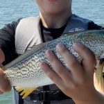
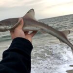
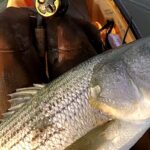
The vibe here is decidedly rugged and quiet. You won't find bustling boardwalks or high-rise condos casting shadows on the water. Instead, the horizon is dominated by cordgrass and the open expanse of the bay. It is a destination for those who prefer solitude and are willing to navigate the challenges of a shallow-water estuary. The primary draw here includes striped bass, weakfish, and blue crabs, all thriving in the brackish mix where the creek meets the bay.

Expert captains know that this fishery is biologically dense. The area boasts the largest population of spawning horseshoe crabs in the world and the second-largest concentration of migrating shorebirds in the Western Hemisphere. This biological richness translates directly to the food chain, attracting game fish to the shallows. However, the very mudflats that support this life can trap the unprepared mariner, making local knowledge of the channels essential.

Access & Getting There

Reaching Fortescue Creek requires a commitment to back roads and a departure from the main highway arteries. Located in Downe, New Jersey, the approach is generally low-traffic, but the final miles are on smaller coastal roads where speed limits drop and wildlife crossings are frequent. Access to the water is primarily facilitating through local ramps and the nearby wildlife refuges. There are three identified boat launch points in the immediate vicinity, ranging from less than half a mile to 2.3 miles from the central creek area. These are functional, utility-focused launch sites rather than luxury facilities.

The launch realities here are dictated entirely by the tide. The ramps are generally trailer-accessible, but the gradient can be tricky at dead low tide. The mudflats in this region are unforgiving; launching a larger draft vessel requires strict adherence to the tide charts. Experienced locals generally aim to launch on the rising tide to ensure safe passage through the creek mouth out to the bay.

💡 Captain's Tip: Tides & Topography

The mudflats here are extensive. Never stray from the marked channels on a falling tide. Local pros recommend marking your track line on a high tide entry to ensure a safe return if you stay out through the ebb.

Weather is the primary gatekeeper for this fishery. The Delaware Bay is notorious for its short, steep chop when the wind bucks the tide. A strong northwest wind can drain the creek, making recovery at the ramp difficult, while a stiff southerly wind can stack water and create rough conditions at the creek mouth. Parking at the local access points is available but limited; unlike the massive lots at ocean inlets, these spots are designed for lower volume. Security is generally good due to the remote nature of the community, but standard precautions apply.

Fortescue Creek, New Jersey Pre-Trip Checklist

Facilities & Amenities

Infrastructure around Fortescue Creek is sparse, which is part of its charm but a logistical challenge for the unprepared. You will not find a "superstore" marine center at the water's edge. The closest reliable source for bait and essential gear is Hooked On Fishing, Not On Drugs - Cumberland County in Leesburg, located approximately 8.5 miles away. For heavy-duty offshore gear or specialized marine electronics support, you are looking at a haul to Boulevard Bait & Tackle in Ocean View or Off the Hook Marina Bait & Tackle in Cape May, both over 23 miles distant. This means you must arrive fully stocked; running back to the shop for a forgotten spool of leader is a trip-ending mistake.

The local charter fleet is largely based out of the larger hubs to the south. Operators like Salty Grunt Sportfishing and Atlantic Adventure run out of the Cape May area, often making the run north to fish the bay structure. If you are looking to hire a guide, expect to meet them at the southern marinas rather than at the creek itself.

💡 Captain's Tip: The "Negative" Logistics

Be aware that the local boat ramps listed have no restrooms, showers, or fish cleaning stations. Plan your comfort stops accordingly before hitting the landing, and bring a cooler to transport your catch whole for cleaning at home.

For anglers planning a multi-day assault on the bay, lodging options are rustic and centered around camping. Lazy River Campground in Estell Manor (19.4 miles) and Jersey Shore Haven Airstream Park offer proximity for those towing travel trailers. For a more conventional stay, Cape May Crossing provides accommodation, though it is a roughly 24-mile drive to the launch, necessitating an early start for dawn patrol.

Facility TypeNameDistanceNotes
Bait & TackleHooked On Fishing, Not On Drugs8.5 milesClosest option; essential for last-mile supplies.
ParkingParking Booths (Millville)10.1 milesNearest formal parking facility outside the immediate ramp areas.
LodgingLazy River Campground19.4 milesGood option for anglers towing campers.
Charter FleetSalty Grunt Sportfishing24.6 milesBased in Cape May; open 24 hours for booking.

Permits, Regulations & Fees

Fishing this region places you in the middle of a highly sensitive ecological zone. The waters are influenced by the Bombay Hook National Wildlife Refuge and the Cape May National Wildlife Refuge. While recreational fishing is a celebrated activity here, it is strictly managed to protect the habitat. Regulations are enforced by the State Fishing Agency, and anglers must possess a valid state saltwater registry or license. Because this is a shared border water with Delaware, be acutely aware of state boundary lines in the middle of the bay to avoid jurisdictional issues.

The area's designation as a Ramsar Wetland of International Importance underscores the need for "leave no trace" practices. Special attention must be paid during the spring horseshoe crab spawning season. These animals are protected, and their eggs are the fuel for the migratory shorebirds that define the region. Disturbing spawning crabs or sensitive marsh banks is a serious offense. Additionally, parts of the Delaware National Estuarine Research Reserve may have specific restrictions on speed or anchoring to protect research plots; always check the latest notices at the launch.

Events & Seasonal Information

The rhythm of Fortescue Creek is seasonal. The spring brings the legendary horseshoe crab spawn, a prehistoric spectacle that draws nature lovers and biologists. For the angler, this signals the arrival of drum and striped bass looking to feed on the eggs. Summer settles into a pattern of blue crabs and resident weakfish, while the fall migration sees the return of stripers pushing bait into the creeks.

While there are no major tournaments hosted directly on the creek's banks, the surrounding Delaware Bay is the arena for various regional tournaments, particularly for drum and striped bass in the spring and fall. The best fishing windows are dictated by the wind; early mornings are crucial before the thermal trade winds kick up across the open fetch of the bay. The "golden hour" here is often dead calm, allowing for topwater action before the chop builds.

Contact Information & Resources

For official information regarding access and regulations, the primary point of contact is the Delaware National Estuarine Research Reserve at 302-739-3436. For issues related to the nearby wildlife refuges, contact Bombay Hook National Wildlife Refuge at 302-653-9345. In an emergency, rely on VHF Channel 16, but be aware that cell service can be spotty in the low-lying marsh areas. Self-reliance is key; carry a backup battery and a visual distress signal.

For precise locations of the boat ramps, real-time wind conditions, and the locations of the nearest bait shops mentioned above, consult the live dashboard and interactive maps below.

🎣

Fortescue CreeK, New Jersey

Downe • New Jersey • 39.2379, -75.1719
🅿️

Parking

5
Parking booths
⭐ 5.0 10.1 mi
📍 8000 Dividing Creek Rd, Millville, NJ 08332, USA
🚗 Get Directions
Goodman's Sealcoating & Paving
⭐ 5.0 18.6 mi
📍 75 S Delsea Dr, Cape May Court House, NJ 08210, USA
🕒
Monday: 8:00 AM – 6:00 AM
Tuesday: 8:00 AM – 6:00 PM
Wednesday: 8:00 AM – 6:00 PM
Thursday: 8:00 AM – 6:00 PM
Friday: 8:00 AM – 5:00 PM
Saturday: 8:00 AM – 5:00 PM
Sunday: 8:00 AM – 5:00 PM
🚗 Get Directions
Truck Parking Club
⭐ 5.0 18.7 mi
📍 214 N Delsea Dr, Vineland, NJ 08360, USA
🕒
Monday: Open 24 hours
Tuesday: Open 24 hours
Wednesday: Open 24 hours
Thursday: Open 24 hours
Friday: Open 24 hours
Saturday: Open 24 hours
Sunday: Open 24 hours
🚗 Get Directions
Cape May County Park East
⭐ 4.7 21.7 mi
📍 25 Crest Haven Rd, Cape May Court House, NJ 08210, USA
🕒
Monday: 7:00 AM – 7:00 PM
Tuesday: 7:00 AM – 7:00 PM
Wednesday: 7:00 AM – 7:00 PM
Thursday: 7:00 AM – 7:00 PM
Friday: 7:00 AM – 7:00 PM
Saturday: 7:00 AM – 7:00 PM
Sunday: 7:00 AM – 7:00 PM
🚗 Get Directions
Columbia Self Storage
⭐ 4.6 15.1 mi
📍 4281 S Lincoln Ave, Vineland, NJ 08361, USA
🕒
Monday: 9:00 AM – 5:00 PM
Tuesday: 9:00 AM – 5:00 PM
Wednesday: Closed
Thursday: 9:00 AM – 5:00 PM
Friday: 9:00 AM – 5:00 PM
Saturday: 9:00 AM – 3:00 PM
Sunday: Closed
🚗 Get Directions
🐟

Bait & Tackle

3
Hooked On Fishing, Not On Drugs - Cumberland County
⭐ 5.0 8.5 mi
📍 198 Matts Landing Rd #176, Leesburg, NJ 08327, USA
🚗 Get Directions
Boulevard Bait & Tackle
⭐ 4.9 23.9 mi
📍 535 Sea Isle Blvd, Ocean View, NJ 08230, USA
🕒
Monday: Closed
Tuesday: Closed
Wednesday: Closed
Thursday: Closed
Friday: 6:30 AM – 4:00 PM
Saturday: 6:30 AM – 4:00 PM
Sunday: 6:30 AM – 12:00 PM
🚗 Get Directions
Off the Hook Marina Bait & Tackle
⭐ 4.9 24.9 mi
📍 989 Ocean Dr, Cape May, NJ 08204, USA
🕒
Monday: Closed
Tuesday: 9:00 AM – 4:00 PM
Wednesday: 9:00 AM – 4:00 PM
Thursday: 9:00 AM – 4:00 PM
Friday: 9:00 AM – 4:00 PM
Saturday: 9:00 AM – 4:00 PM
Sunday: Closed
🚗 Get Directions
🚤

Fishing Charters

3
Salty Grunt Sportfishing
⭐ 5.0 24.6 mi
📍 926 Ocean Dr, Cape May, NJ 08204, USA
🕒
Monday: Open 24 hours
Tuesday: Open 24 hours
Wednesday: Open 24 hours
Thursday: Open 24 hours
Friday: Open 24 hours
Saturday: Open 24 hours
Sunday: Open 24 hours
🚗 Get Directions
Avalon Fishing Charters
⭐ 5.0 25.0 mi
📍 701 Old Avalon Blvd Unit #4, Avalon, NJ 08202, USA
🕒
Monday: Open 24 hours
Tuesday: Open 24 hours
Wednesday: Open 24 hours
Thursday: Open 24 hours
Friday: Open 24 hours
Saturday: Open 24 hours
Sunday: Open 24 hours
🚗 Get Directions
Atlantic Adventure
⭐ 5.0 24.4 mi
📍 1231 NJ-109, Cape May, NJ 08204, USA
🕒
Monday: Open 24 hours
Tuesday: Open 24 hours
Wednesday: Open 24 hours
Thursday: Open 24 hours
Friday: Open 24 hours
Saturday: Open 24 hours
Sunday: Open 24 hours
🚗 Get Directions
🏠

Lodging

5
Cape May Crossing
⭐ 5.0 23.9 mi
📍 878 NJ-109, Cape May, NJ 08204, USA
🕒
Monday: 8:30 AM – 5:30 PM
Tuesday: 8:30 AM – 5:30 PM
Wednesday: 8:30 AM – 5:30 PM
Thursday: 8:30 AM – 5:30 PM
Friday: 8:30 AM – 5:30 PM
Saturday: Closed
Sunday: Closed
🚗 Get Directions
Jessie Creek Winery
⭐ 4.6 18.6 mi
📍 1 Route 47 North, Cape May Court House, NJ 08210, USA
🕒
Monday: 12:00 – 5:00 PM
Tuesday: 12:00 – 5:00 PM
Wednesday: 12:00 – 5:00 PM
Thursday: 12:00 – 5:00 PM
Friday: 12:00 – 6:00 PM
Saturday: 11:00 AM – 6:00 PM
Sunday: 12:00 – 6:00 PM
🚗 Get Directions

Boat Ramps

3
🚻

Restrooms

3
👨‍👩‍👧‍👦

Family Friendly

2

Accessibility

Wheelchair Access

Not Confirmed

🐕

Pets Allowed

Not Confirmed

⚠️ Some accessibility info not officially confirmed. Please verify with location directly.

📍 Showing 24 facilities on map
🎣
Book a Fishing Charter near Fortescue CreeK, New Jersey Fishing Report Today 🎣

Local guides & charters. Verified captains, instant booking, best price guaranteed.

See Available Trips →

📊

About Our Fishing Reports & Forecasts

Our spot reports combine data-driven forecasts with curated local information. The forecast is generated by our proprietary Fishing Score algorithm (0–100%), which analyzes real-time data from Open-Meteo API, validated against NOAA CO-OPS tide gauges and USGS water-monitoring stations. The model weights tide dynamics (35%), wave energy (25%), wind patterns (20%) and time of day (20%)—factors shown to influence fish feeding behavior through marine-biology research and decades of charter log data.

Access, facilities and services information for each fishing spot is sourced from official datasets such as Recreation.gov (RIDB), state park & wildlife agencies, and geospatial providers like Google Maps. These sections undergo scheduled re-validation every 3–6 months to ensure that boat ramps, park access, contact details and local services remain accurate.

Narrative sections (catches, seasonal behavior, local tips) are synthesized from these data sources and refined following the Fishing Reports Today editorial guidelines, combining bibliographic research from ichthyology and oceanography with expert angler experience. Our team reviews reports on a regular basis, while the forecast model itself updates every 6 hours for real-time accuracy.

⚠️ Important: Always verify current local regulations, access restrictions and weather conditions before fishing. These reports are intended as a planning aid, not a guarantee of catches or safety. When in doubt, contact local authorities or park managers listed on the page.

Learn more about our methodology & data sources

Leave a Reply

Your email address will not be published. Required fields are marked *