Current seasonal conditions are absolutely prime for offshore and nearshore anglers alike. We are witnessing a classic summer setup amplified by Epic El Nino conditions, which have pushed beautiful, warm 70-degree water deep into the Southern California bight. Weather patterns are highly favorable for the foreseeable future, featuring manageable north winds hanging around 5 to 10 knots and typical marine layer mornings that reliably burn off by midday to reveal clear skies. The ocean is laying down beautifully, making for a safe and comfortable ride whether you are pushing offshore for pelagics in a center console or working the coastal kelp forests in a pedal-drive kayak. There are no major weather or small craft advisories in effect. The water clarity is stellar, and the fish are actively feeding. Fuel up, prep your gear, and get on the water.
SPECIES INTEL
Primary Target
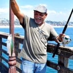
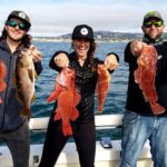
Yellowtail and Calico Bass. The influx of warm water has ignited a spectacular Yellowtail (Amberjack) bite just a mile or two off the harbor mouth. Fish in the solid 20 to 60-pound class are holding tight to offshore kelp patties in 200-plus feet of water, creating world-class surface strikes. Meanwhile, the nearshore Calico Bass (Kelp Bass) bite is absolutely wide open. Local sportfishing boats are reporting triple-digit release days, with highly aggressive bass crushing anything moving through the upper water column.
🎣Nautrek
Private Beta
J
M
R
100+ anglers on the waitlist
The fishing network where your reputation matters.
Find trusted captains, join real trips with cost splitting, and build your Angler Rank. Your spots stay private — you decide who sees your intel.
California Sheephead. While the majority of the fleet is constantly looking up for topwater surface action, massive Sheephead are quietly dominating the deep bottom structure. The local kelp beds are hiding some beautiful, legal-sized females and heavily-armored, bucket-headed males that most anglers are simply driving right over in search of exotics.
Baitfish Report
The forage base is exceptionally healthy and abundant right now. Massive bait balls of Pacific mackerel, anchovies, and sardines are present just outside the breakwater, often pushed to the surface by predatory fish below. Match your lure profiles to these 4-to-6-inch baits to maximize your strikes. If you can make your own bait, a sabiki rig dropped near the harbor entrance will fill your livewell in minutes.
TACTICAL STRATEGY
Where
Focus your nearshore efforts heavily on the Salt Creek Kelp bed. This sprawling, dense forest stretches for roughly a mile along Salt Creek Beach and is a haven for coastal predators. Position your vessel on the outside edge in 50 to 70 feet of water for a shot at cruising Yellowtail or ghost-like White Seabass patrolling the perimeter. For Calico Bass and Sheephead, slide to the inside edge near the Ritz Carlton in 35 to 45 feet of water where the kelp stalks meet the rocky reef. Alternatively, The Pipe—a well-known spill pipe running from the mainland out to a depth of 90 feet—is holding excellent concentrations of fish right on the 30-to-50-foot depth contour. Start at the marker buoy and work your way offshore.
Lure & Bait Selection
Lures: For the Yellowtail, you cannot beat throwing a Tady 45 or Salas 7X surface iron. For the Calicos hiding in the salad, rig a 5-inch weedless swimbait on a 3/4-ounce leadhead to penetrate the thick kelp canopy without snagging.
Colors: Mint and white or blue and white are the undeniable tickets for the surface irons right now. For swimbaits, stick to natural baitfish patterns like anchovy, smelt, or clear with heavy silver flake to mimic the local sardine population.
Bait: Fly-lining a lively, green-backed sardine on a size 2 or 1/0 circle hook with absolutely no weight is deadly for the Yellowtail on the outside patties. Let the bait swim naturally. If you are targeting Sheephead, drop a heavy dropper loop rig down to the rocky bottom pinned with fresh dead squid or crushed crab.
Pro Tip: When throwing surface irons for Yellowtail, the retrieval speed is everything. Cast past the kelp patty, let the jig sink for three to five seconds, and utilize a medium-fast, steady retrieve. Do not pump the rod. When the fish strikes, keep winding until the rod completely loads up before setting the hook.
Pro Tip: When fishing the Salt Creek Kelp, pay close attention to the tidal current. Always set up your drift or anchor up-current from the kelp line and chum a few cut pieces of mackerel to draw the Calico Bass out of the heavy structure and into the open water where you have a better chance of landing them.
Timing
The gray light period at dawn is absolutely critical for the surface iron Yellowtail bite, as they are most willing to chase lures in low-light conditions. However, current solunar data indicates a surprisingly strong secondary feeding window pushing into the early afternoon around 2:00 PM. If you miss the morning bite, stick it out through the tide swing and be ready for the afternoon flurry.
REGULATIONS SNAPSHOT
Before you drop a line, ensure you are fully compliant with current California Department of Fish and Wildlife ocean regulations. Note that while you are fishing within the Dana Point State Marine Conservation Area (SMCA), recreational hook-and-line fishing from a vessel or kayak is permitted. However, any take from the shoreline tidepools is strictly prohibited.
Species
Minimum Size
Bag Limit
Calico Bass (Kelp Bass)
14 inches (Total Length)
5 per day
California Sheephead
12 inches (Total Length)
5 per day
Yellowtail
24 inches (Fork Length)
10 per day (only 5 under 24")
White Seabass
28 inches (Total Length)
3 per day
Pro Tip: Total length for Calico Bass means measuring from the most forward point of the head to the farthest tip of the tail while the fish is lying flat and the tail is physically compressed or squeezed together. A 13.9-inch fish will earn you a hefty fine, so measure carefully and release the shorts quickly to ensure their survival.
REGIONAL ALTERNATIVE
If the Dana Point harbor traffic is too heavy, the boat ramps are overflowing, or the offshore patties have been picked clean by the sportboat fleet, do not hesitate to head south down the coast to San Clemente. The submerged rock formations sitting just south of the San Clemente Pier serve as phenomenal, low-pressure backup spots.
These jagged rocks rise dramatically off the sandy bottom and hold massive numbers of Barred Sand Bass, Calicos, and a variety of bottom fish including tasty Rockfish. Approach this zone cautiously, keeping a close eye on your sonar unit to avoid running aground on the tallest pinnacles, as they can sneak up on you during a low tide. Drop 3-ounce to 4-ounce torpedo sinkers with squid strips right onto the rock piles, or cast small, heavy swimbaits around the perimeter of the structure. It is a highly productive zone that sees only a fraction of the boating pressure compared to the waters directly in front of Dana Point.
Tight lines!
Editor's Choice: Must-Have Gear
FISHINGSIR Next-Gen Waterproof Chest Waders
★★★★★4.4 (7,370+ reviews)
2-Ply Tech: Upgraded nylon with 2.5x higher density than standard fabrics.
100% Waterproof: Lab-approved intrusion resistance with taped visible seams.
Ultra-Lightweight: Designed for all-day comfort while hunting or fishing.
As an Amazon Associate I earn from qualifying purchases. #ad
Loading forecast...
Live Fishing Conditions: Tides, Weather & Waves
Get real‑time tides, marine weather, swell and solunar activity for each spot so you know exactly when conditions line up for your best chance at a bite.
🎣
Dana Point
Loading coordinates...
🌤️
WEATHER CONDITIONS
--°F
--°C
Loading...
🌡️
Feels Like--°F--°C
💧
Humidity--%
💨
Wind-- mph-- km/h
🧭
Direction--
📊
Pressure-- inHg-- hPa
☀️
UV Index--
🌊
MARINE CONDITIONS
🌊Wave Height
-- ft
-- m
Loading...
🧭Wave Direction
--°
Loading...
⏱️Wave Period
-- s
Loading...
📈Tide Status
-- ft
-- m
Loading...
🌙
LUNAR & SOLUNAR
🌕
Loading...
Illumination: --%
Major Period--:-- - --:----:-- - --:--
Minor Period--:-- - --:----:-- - --:--
🌅Sunrise--:--
🌇Sunset--:--
📅
24-HOUR FORECAST
Loading fishing conditions...
Fishing Spots Map
🎣
Book a Fishing Charter near Dana Point Fishing Report Today 🎣
Local guides & charters. Verified captains, instant booking, best price guaranteed.
There was an error loading the map. Please try refreshing the page.
Info
Local Access & Facilities
Dana Point stands as one of Southern California's premier gateways to the Pacific, offering a sophisticated blend of accessibility and productive water. Situated in Laguna Beach, this fishery is characterized by its dramatic coastal cliffs and deep-water access that doesn't require hours of running time. The harbor atmosphere here strikes a balance between a polished recreational marina and a serious sportfishing hub, attracting anglers targeting coastal bass, halibut, and migratory pelagics.
For the experienced captain, this location serves as a strategic launchpad into the nutrient-rich currents of the Santa Barbara Channel's southern edge. The bottom topography in this region varies from sandy flats near the shore to rocky reefs and drop-offs further out, providing diverse habitats for game fish. Whether you are launching a private vessel or patrolling the shoreline, the infrastructure here is designed to support high-volume maritime traffic while maintaining a distinct local charm.
The primary draw for seasoned anglers is the proximity to cooler, nutrient-rich upwellings that attract yellowtail and white seabass during the transition seasons. Unlike the industrial sprawl of northern harbors, Dana Point maintains a cleaner, more navigable environment. It is a location where preparation meets opportunity, provided you understand the logistical nuances of the local ramps and weather patterns.
Access & Getting There
Reaching the water at Dana Point generally involves navigating the Pacific Coast Highway (CA-1), a route that is scenic but prone to heavy congestion during weekends and summer months. Experienced locals know to time their arrival well before the morning rush to secure prime positioning. The data indicates multiple boat ramps located approximately 2.9 miles from the central spot coordinates, facilitating launch capabilities for trailered vessels.
For those hauling heavy gear, trailer parking is available at the ramps, though capacity can be tested during peak season. If you are coordinating a meetup or utilizing public transit to reach the general area, the San Clemente Metrolink Station is located roughly 6.8 miles away, offering a logistical alternative for crew members traveling from San Diego or Los Angeles. While there are parking structures like Ampco System Parking and the Century Centre, these are significantly further inland (over 15 miles), making them impractical for immediate boat access but useful for overflow or long-term logistical planning.
💡 Captain's Tip: Launch Logistics
The boat ramps here are fully functional but can get slick at low tide. Ensure your vehicle has adequate traction and check the local tide charts before backing down. Early arrival is not just a suggestion; it is a necessity to avoid the recreational crowds that swell by mid-morning.
Shore access is a viable alternative for those without a hull. There are designated shore access points identified in the local data that are suitable for shore fishing and families. These spots allow anglers to work the surf line for corbina and perch. Be mindful that specific parking for these shore entries can be tight; the San Clemente Pier Metrolink Parking Lot (7.8 miles away) serves as a reference point for coastal access further south if the immediate harbor spots are full.
Dana Point Pre-Trip Checklist
Facilities & Amenities
The logistical support for anglers in this region is robust, with specialized shops catering to serious sportfishing needs. The standout facility for gear and local intelligence is Hogan's Bait & Tackle, located just 3.1 miles from the harbor on CA-1. Rated highly by the community, this shop is a critical stop for fresh bait and terminal tackle. Note that their operating hours are Tuesday through Saturday from 9:00 AM to 5:00 PM; they are closed on Sundays and Mondays, so weekend warriors must plan their provisioning accordingly.
For those seeking a guided experience or heavy-tackle offshore runs, the local fleet is anchored by reputable operations like Pacific Mistress Sportfishing. Situated only 2.8 miles away at 34571 Golden Lantern, this charter service opens as early as 5:00 AM, perfectly aligning with the "dawn patrol" mentality required for successful fishing. Another option, though further afield in Huntington Beach (24 miles away), is Wagner Charters, which operates 24 hours a day for flexible scheduling.
💡 Captain's Tip: Provisioning Alert
Hogan's Bait & Tackle is closed on Sundays and Mondays. If you are planning a trip early in the week, ensure you buy your frozen bait and terminal tackle on Saturday afternoon to avoid being caught empty-handed at the ramp.
Accommodations in the area range from high-end luxury to functional stays. For anglers who want to wake up within sight of the ocean, Montage Laguna Beach offers premium lodging just 2.6 miles away. For a more nature-immersive experience, Crystal Cove State Park offers accommodation options roughly 7.9 miles up the coast. If you prefer camping, the Arroyo Campground and Trabuco Creek Picnic Site are available, though they are located over 14 miles inland, requiring a commute to the harbor.
Public amenities near the water are adequate, with multiple public restrooms located within a mile radius of the main activity zones. This availability is crucial for long days on the water or when managing family outings along the shore. However, always verify the status of fish cleaning stations at the ramp, as local availability can fluctuate.
Permits, Regulations & Fees
Fishing activities in Dana Point and the surrounding Laguna Beach waters are strictly managed by the State Fishing Agency. Compliance is not optional; it is a prerequisite for preserving this fishery. Anglers must possess a valid California sport fishing license, with specific validations required for ocean fishing. The region is adjacent to several Marine Protected Areas (MPAs), particularly near Crystal Cove State Park, where take may be restricted or prohibited entirely.
While the official data indicates "No environmental alerts detected" currently, regulations regarding size limits and seasonal closures for species like lingcod, rockfish, and sheepshead change frequently. It is the skipper's responsibility to consult current charts and official state sources before wetting a line. Ignorance of MPA boundaries is not a valid defense in these waters.
Access to certain inland recreation areas nearby, such as the Holy Jim/Los Pinos Area or Trabuco Creek, requires an Adventure Pass for parking and entry. While these are secondary to the saltwater fishery, they represent the broader regulatory landscape of the region. Always carry identification and permits in a waterproof holder, as enforcement patrols are common both on the water and at the launch ramp.
Events & Seasonal Information
The fishing calendar in Dana Point follows the classic Southern California rhythm. The warmer months bring the pelagic species within range of the local fleet, while the cooler months shift the focus to structure-oriented rockfish and halibut. The charter fleets, including Breakaway Sportfishing, operate year-round but see peak activity during the summer yellowtail and tuna runs.
Inland, areas like the Trabuco Creek Picnic Site list Spring and Winter as their best seasons, suggesting that the cooler months are ideal for land-based activities if the ocean is blown out. Weather patterns here are dominated by the marine layer in the morning, which typically burns off by noon, followed by afternoon trade winds. The savvy captain plans to be off the water or in protected coves before the afternoon chop builds.
Contact Information & Resources
Safety is paramount when operating in the open Pacific. For emergency assistance, the local harbor patrol and the Coast Guard are the primary contacts. For land-based inquiries or camping information, the Trabuco Ranger District can be reached at (951) 736-1811. For lodging specifics at Crystal Cove State Park, contact (949) 494-3539.
Always file a float plan with a reliable contact on land before departing. Self-reliance is key, but knowing who to call when mechanical failure strikes is equally important. For precise locations, real-time conditions, and detailed mapping of the facilities mentioned, consult the live dashboard and maps below.
🎣
Dana Point
Laguna Beach • California • 33.4816, -117.7347
🅿️
Parking
5
Ampco System Parking
⭐ 5.016.6 mi
📍5 Hutton Centre Dr # 16, Santa Ana, CA 92707, USA
Our spot reports combine data-driven forecasts with curated local information. The forecast is generated by our proprietary Fishing Score algorithm (0–100%), which analyzes real-time data from Open-Meteo API, validated against NOAA CO-OPS tide gauges and USGS water-monitoring stations. The model weights tide dynamics (35%), wave energy (25%), wind patterns (20%) and time of day (20%)—factors shown to influence fish feeding behavior through marine-biology research and decades of charter log data.
Access, facilities and services information for each fishing spot is sourced from official datasets such as Recreation.gov (RIDB), state park & wildlife agencies, and geospatial providers like Google Maps. These sections undergo scheduled re-validation every 3–6 months to ensure that boat ramps, park access, contact details and local services remain accurate.
Narrative sections (catches, seasonal behavior, local tips) are synthesized from these data sources and refined following the Fishing Reports Today editorial guidelines, combining bibliographic research from ichthyology and oceanography with expert angler experience. Our team reviews reports on a regular basis, while the forecast model itself updates every 6 hours for real-time accuracy.
⚠️ Important: Always verify current local regulations, access restrictions and weather conditions before fishing. These reports are intended as a planning aid, not a guarantee of catches or safety. When in doubt, contact local authorities or park managers listed on the page.
To provide the best experiences, we use technologies like cookies to store and/or access device information. Consenting to these technologies will allow us to process data such as browsing behavior or unique IDs on this site. Not consenting or withdrawing consent, may adversely affect certain features and functions.
Functional Always active
The technical storage or access is strictly necessary for the legitimate purpose of enabling the use of a specific service explicitly requested by the subscriber or user, or for the sole purpose of carrying out the transmission of a communication over an electronic communications network.
Preferences
The technical storage or access is necessary for the legitimate purpose of storing preferences that are not requested by the subscriber or user.
Statistics
The technical storage or access that is used exclusively for statistical purposes.The technical storage or access that is used exclusively for anonymous statistical purposes. Without a subpoena, voluntary compliance on the part of your Internet Service Provider, or additional records from a third party, information stored or retrieved for this purpose alone cannot usually be used to identify you.
Marketing & Affiliates
The technical storage or access is required to create user profiles to send advertising, or to track the user on a website or across several websites for similar marketing purposes, including affiliate tracking for products recommended in our reports.


Leave a Reply