Connecticut Spring Fishing Report: Candlewood Lake & Farmington River
GO/NO-GO STATUS
Verdict: GO
Spring conditions have fully taken hold across Connecticut, making this one of the most productive windows of the entire angling season. Water temperatures on our major reservoirs, including Candlewood Lake, are currently holding in the upper 50s to low 60s. This temperature band triggers an aggressive active-water pattern for both warm and cold-water species. The barometric pressure has been relatively stable, creating extended feeding windows throughout the morning.
Weather Impact & Safety Advisory: The spring turnover is complete, and water clarity is exceptional. However, spring winds can whip up quickly through the western Connecticut valleys. While a steady chop is excellent for pushing baitfish against windward shorelines and masking your approach, it can make boat control challenging on expansive flats. Although the ice is long gone, water temperatures are still cold enough to present a severe hypothermia risk if you take an unexpected swim. Always wear your personal flotation device (PFD) while underway, and exercise extreme caution when navigating near rocky points and shoals during high winds.
🎣Nautrek
Private Beta
J
M
R
100+ anglers on the waitlist
The fishing network where your reputation matters.
Find trusted captains, join real trips with cost splitting, and build your Angler Rank. Your spots stay private — you decide who sees your intel.
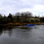
Candlewood Lake is Connecticut's crown jewel for bass fishing, and right now, the smallmouth and largemouth bass are the undisputed main events. The fish are heavily feeding as they transition through their pre-spawn and spawning phases, holding tight to structural transitions, submerged timber, and emerging vegetation.
Sleeper Pick: Black Crappie
While the bass boats crowd the prominent points, the Black Crappie bite is exceptional and largely ignored by the masses. These schooling panfish are currently staging near submerged brush piles and the edges of early milfoil growth in 8 to 15 feet of water. They provide phenomenal light-tackle action, are eager to bite, and make for excellent table fare.
Baitfish Report:
The primary forage driving the predatory bite right now is the landlocked alewife. These baitfish are pushing toward shallower coves and rocky shorelines in massive schools, drawing big smallmouths out of the deep basin. Matching the size, profile, and flash of a struggling alewife is critical for moving baits.
TACTICAL STRATEGY
Where:
On Candlewood Lake, bypass the featureless banks and focus your efforts near Squantz Cove and the steep, rocky drop-offs along the eastern shoreline. Early in the morning, target the main-lake flats and visible pockets in 2 to 6 feet of water where the water warms up the fastest. As the sun gets high and penetrates the clear water, slide your boat out to the 6 to 12-foot drop-offs where the shallow flats plunge into the main basin. If you are utilizing forward-facing sonar, scan the transition zones for cruising wolf packs of smallmouth bass.
Lure Selection:
When fishing the shallow pockets and flats, a slow and methodical approach is best. Tie on a 3/8oz finesse jig paired with a matching chunk trailer. If the wind picks up above 10 mph and creates a chop on the water, switch gears to a 1/2oz double-willow spinnerbait or a suspending jerkbait to cover water and trigger reaction strikes from cruising bass.
Color Patterns:
For your bottom-contact jigs, stick to natural tones like green pumpkin, watermelon seed, or brown to mimic local crayfish and blend into the ultra-clear water. For your spinnerbaits and moving lures, white, translucent clear, and chartreuse skirts with silver blades are essential to imitate the local alewife population.
Bait & Rigging:
If you prefer fishing live bait, large golden shiners are the ticket. Rig them on a slip bobber setup using a 1/8oz egg sinker and a size 1/0 circle hook. Target the deep edges of emerging weedlines, setting your bobber stop so the bait hovers about two feet off the bottom to keep it in the strike zone without snagging.
Timing:
The golden hours are paramount right now. The best feeding window occurs from first light until mid-morning before the sun pushes the fish deeper into cover. A secondary, slightly less intense feeding window opens in the late afternoon as the water reaches its peak daily temperature.
Pro Tip:When fishing finesse jigs in clear spring water, resist the urge to over-work the bait. Drag it slowly across the bottom and incorporate 5 to 10-second pauses. Spooky, pre-spawn bass will often pick up the jig while it is sitting dead still. Watch your line closely for subtle ticks.
REGULATIONS SNAPSHOT
Before hitting the water, ensure your Connecticut fishing license is up to date. Here are the critical regulations to keep in mind for our target species:
Current state regulations mandate a 9-inch minimum.
Trout (Upper TMA)
N/A
0 (Catch & Release)
Barbless, single-hook artificials only.
Black Crappie
7 inches
30
Excellent sleeper target right now.
Trout and Salmon Stamp: If you plan to fish any designated Trout Management Area (TMA), you must possess a valid Trout and Salmon Stamp in addition to your standard fishing license.
Invasive Species Prevention: Candlewood Lake is under strict monitoring for invasive species. Ensure your boat, trailer, and gear are thoroughly washed and dried before launching to prevent the spread of zebra mussels and hydrilla.
REGIONAL ALTERNATIVE: Farmington River
If the wind is howling too hard to safely fish the expansive waters of Candlewood Lake, or if you simply prefer wading in moving water, the Farmington River is your premier backup plan. Recognized as a world-class trout fishery right in the heart of New England, the Farmington offers miles of accessible, highly productive water.
Access and Target Species:
Head to the West Branch of the Farmington River, specifically the Trout Management Areas (TMAs) between the Route 318 Bridge and the Route 219 Bridge in New Hartford. The Connecticut DEEP has recently completed their massive spring stocking program, depositing over 500,000 Brook, Brown, Rainbow, and Tiger Trout into the state's waters. The cold-water releases from the Goodwin Dam keep the river temperatures in the optimal 50-degree range, making for highly active fish even when surrounding lakes get too warm.
Tactical Approach:
The Upper TMA is renowned for its classic pools and deep boulder pockets. Because this section is strictly catch-and-release year-round, you must use barbless, single-hook artificial lures or flies. Fly anglers should look for rising fish and match the hatch with blue-winged olives or small caddis dry flies. If there is no surface activity, tight-line nymphing with heavily weighted tungsten bead-head nymphs (sizes 16-18) through the deep runs is incredibly effective. For spin anglers, single-hook barbless inline spinners cast upstream and retrieved just faster than the current will draw aggressive strikes from territorial brown trout.
Pro Tip:The Farmington River experiences heavy angling pressure, especially on spring weekends. To find unpressured fish, bypass the easily accessible bridge pools. Put on your waders and hike a half-mile away from the parking areas to find isolated pocket water where trophy holdover trout ambush drifting nymphs.
Tight lines!
Editor's Choice: Must-Have Gear
FISHINGSIR Next-Gen Waterproof Chest Waders
★★★★★4.4 (7,370+ reviews)
2-Ply Tech: Upgraded nylon with 2.5x higher density than standard fabrics.
100% Waterproof: Lab-approved intrusion resistance with taped visible seams.
Ultra-Lightweight: Designed for all-day comfort while hunting or fishing.
As an Amazon Associate I earn from qualifying purchases. #ad
Loading forecast...
Live Fishing Conditions: Tides, Weather & Waves
Get real‑time tides, marine weather, swell and solunar activity for each spot so you know exactly when conditions line up for your best chance at a bite.
🎣
Connecticut
Loading coordinates...
🌤️
WEATHER CONDITIONS
--°F
--°C
Loading...
🌡️
Feels Like--°F--°C
💧
Humidity--%
💨
Wind-- mph-- km/h
🧭
Direction--
📊
Pressure-- inHg-- hPa
☀️
UV Index--
🌊
MARINE CONDITIONS
🌊Wave Height
-- ft
-- m
Loading...
🧭Wave Direction
--°
Loading...
⏱️Wave Period
-- s
Loading...
📈Tide Status
-- ft
-- m
Loading...
🌙
LUNAR & SOLUNAR
🌕
Loading...
Illumination: --%
Major Period--:-- - --:----:-- - --:--
Minor Period--:-- - --:----:-- - --:--
🌅Sunrise--:--
🌇Sunset--:--
📅
24-HOUR FORECAST
Loading fishing conditions...
Fishing Spots Map
🎣
Book a Fishing Charter near Connecticut Fishing Report Today 🎣
Local guides & charters. Verified captains, instant booking, best price guaranteed.
There was an error loading the map. Please try refreshing the page.
Info
Local Access & Facilities
Central Connecticut: The Naugatuck Valley Fishery
The central Connecticut fishing landscape, anchored around Newington and extending into the Naugatuck Valley, offers a distinct tactical change from the open waters of the Long Island Sound. This is a region defined by precision freshwater angling, where the industrial history of the valley meets aggressive natural reclamation. For the expert angler, this area presents a series of "pocket" fisheries—specifically Hop Brook Lake, Northfield Brook Lake, and Hancock Brook Lake—that require a shift in mindset from heavy trolling to technical casting. The topography here is characterized by rolling hills and hardwood forests, providing natural windbreaks that often keep surface conditions manageable even when coastal gusts render the Sound unfishable.
The primary draw for seasoned rods in this sector is the diverse freshwater portfolio managed by the U.S. Army Corps of Engineers and the State of Connecticut. While casual visitors flock to the beaches, the serious angler knows these waters for their seasonal trout dynamics and resident warmwater game fish. The waters here are periodically stocked with Brown, Brook, and Rainbow Trout, creating a high-stakes spring and fall fishery. As the water warms, the focus shifts to structure-oriented Largemouth Bass, Perch, and Panfish. The environment ranges from the shallow, vegetation-rich 40 acres of Hancock Brook Lake to the deeper, 536-acre recreational footprint of Hop Brook Lake.
This is not a fishery for large center consoles or high-speed runabouts; it is the domain of the kayak angler, the canoeist, and the shore-bound tactician. The atmosphere is deceptive; while located near the urban centers of Waterbury and Naugatuck, the immediate surroundings of the lakes are heavily forested with maple, oak, and hemlock, creating a sense of isolation essential for focused angling. The bottom topography varies from river rock in the feeder streams to silt and submerged timber in the impoundments, requiring a versatile tackle box and a willingness to adapt presentations on the fly.
Access & Getting There
Navigating to the prime fishing grounds in this region relies heavily on the Route 8 corridor, which serves as the spinal cord of the Naugatuck Valley. For anglers towing small johnboats or hauling kayaks, this highway provides the most direct link between the coastal populous and the inland reservoirs. Traffic in this corridor can be heavy during commuter hours, particularly around the interchange with I-84 near Waterbury. Seasoned locals know to time their arrival for early morning, bypassing the congestion that builds up by 7:00 AM.
Accessing Hop Brook Lake Recreation Area requires a strategic approach. The entrance is situated at the intersection of CT-63 and CT-188. Coming from Bridgeport, it is a roughly 23-mile run north on Route 8 to Exit 26. The internal roads are paved, a critical detail for those towing trailers, ensuring that you won't be navigating washed-out dirt tracks with a loaded rig. The facility features a designated boat ramp, but captains must be aware of the specific "Launch Realities" here: this is a facility optimized for non-motorized boating. While the ramp is serviceable, it is not designed for deep-draft vessels. The shallow nature of the launch area necessitates checking water levels, especially during late summer drawdowns.
💡 Captain's Tip: The Electric Advantage
While many of these waters are restrictive regarding internal combustion engines, they are prime territory for high-thrust trolling motors. At Hop Brook Lake, rig your kayak or johnboat with a heavy-duty electric motor to punch through wind tunnels in the valley without spooking the pressure-sensitive trout holding near the feeder streams.
Northfield Brook Lake, located further north in Thomaston via Route 254, offers a different access profile. This is largely a day-use scenario where access is often on foot or via light craft. The parking areas here are paved, but capacity can be an issue on peak summer weekends. The "Dawn Patrol" strategy is essential; arriving when the gates open (typically 8:00 AM for vehicles, though walk-in access may vary) guarantees proximity to the water. For Hancock Brook Lake in Plymouth, access is more rugged. Directions involve taking CN 262 to South Main Street. This 40-acre waterbody is shallow and best accessed by canoe or kayak; trailered access is minimal to non-existent compared to the larger reservoirs.
Weather plays a significant role in access logistics. The Naugatuck Valley acts as a funnel for wind and rain. Heavy precipitation events can rapidly change the flow rates of feeder streams and turbidity levels in the reservoirs. Thomaston Dam and its associated waters are flood control projects; during high water events, access points may be submerged or closed for safety. Always check the water levels before hitching the trailer, as a "blown out" river system can make the drive futile.
Connecticut Pre-Trip Checklist
Facilities & Amenities
The infrastructure in this region is tailored towards the self-sufficient angler. You will not find full-service marinas with fuel docks, ice machines, and fish cleaning stations on the water's edge. This is a "bring it in, pack it out" environment. Fueling up must be done at highway stations in Thomaston, Naugatuck, or Middlebury before entering the park grounds. The lack of on-water fuel emphasizes the need for battery management for those running electric outboards.
For gear, bait, and local intelligence, the area is served by several specialized independent retailers rather than big-box marine stores. HOOK’EM ALL OUTDOORS in Berlin (approx. 1.9 miles from the Newington anchor) is a critical resource. Their operating hours extend to midnight on weekdays and start at 5:00 AM on weekends, perfectly aligned with the serious angler's schedule. Whether you need live shiners for bass or specific trout dough, this is the logistical hub. For the fly fishing purist targeting the feeder streams of Hancock Brook or the Naugatuck River, The Local Fly Co. in Bristol offers specialized entomological knowledge and pattern matching that generalist shops cannot match.
💡 Captain's Tip: Tactical Resupply
If you are targeting carp or catfish in the slower impoundments, visit PEAK BAITS LLC in New Britain. Their specialized bait selection is often the difference between a skunk and a banner day when the trout bite shuts down in the midday heat.
The parks themselves offer robust day-use facilities. Hop Brook Lake and Northfield Brook Lake are equipped with specific shelters that can be strategic basecamps for large groups or club outings. Unlike primitive ramps, these locations offer paved parking, restrooms (seasonal flush toilets), and potable water—amenities that allow for full days on the water without returning to civilization. The table below details the specific facilities available for anglers planning group expeditions or tournament weigh-ins.
Facility Name
Location
Key Amenities
Angler Relevance
Hop Brook Lake Rec Area
Middlebury
Paved Parking, Boat Ramp, Electric Hookups, Restrooms
Primary launch for kayaks/canoes; picnic shelters have power for charging batteries during breaks.
Northfield Brook Lake
Thomaston
Paved Parking, Grills, Picnic Shelters
Excellent shore access basecamp; "Knife Shop Shelter" allows for group coordination.
Thomaston Dam
Thomaston
Vista Picnic Area, Off-Highway Vehicle Trails
High vantage point for scouting water conditions; streamside access for trout.
It is crucial to note a significant "Negative Knowledge" regarding lodging. The campsites listed in official data, such as the Mattatuck Scout Reservation or mobile home parks like Western Sands, are generally not open for transient angler camping. Northfield Brook Lake Group Shelters and Hop Brook shelters are for day-use gatherings, not overnight camping. Anglers looking to stay overnight should book accommodations in the nearby urban centers or look for state park campgrounds further afield. Do not plan on sleeping in your truck at the boat ramp; gates typically close at sunset.
Permits, Regulations & Fees
Fishing in the Naugatuck Valley requires strict adherence to state and federal regulations. The managing authority for the fishery rules is the Connecticut Department of Energy and Environmental Protection (DEEP), while the land access is often controlled by the U.S. Army Corps of Engineers. This dual-jurisdiction means anglers must be doubly vigilant. A valid Connecticut Inland Fishing License is non-negotiable for anyone 16 years of age or older. Additionally, if you are targeting the stocked species, a Trout & Salmon Stamp is frequently required to keep your catch.
A notable advantage of the Hop Brook Lake facility is the absence of daily access fees. The data explicitly states that "User Fees are no longer charged to enter the park," removing a common barrier to entry found in other managed recreation areas. However, this ease of access can lead to increased pressure, making regulatory compliance even more critical to maintain the fishery. Conservation officers patrol these high-traffic zones regularly.
Cultural and environmental respect is paramount. These areas are described as escapes from "growing suburbia," and the "Leave No Trace" ethic is strictly enforced to protect the water quality. The feeder streams stocked with trout are sensitive ecosystems. Anglers should be aware of Kapu (a concept of sacredness or restriction, applicable here in the sense of protected zones) regarding the feeder brooks during spawning seasons or specific stocking windows. Always check the current Angler's Guide provided by CT DEEP for specific slot limits on Bass and creel limits on Trout, as these can vary by waterbody and season.
Events & Seasonal Information
The angling calendar in this region is dictated by the stocking trucks and the water temperature. The primary season kicks off in early spring when the state stocks Brown, Brook, and Rainbow Trout. During this window, Northfield Brook Lake and the feeder streams of Hop Brook see the highest activity. The cool water temperatures of spring and late fall are the prime windows for trout. As summer sets in, the shallow nature of Hancock Brook Lake (40 acres) and the surface warming of the larger lakes push the cold-water species deep or into the thermal refuges of the tributaries.
💡 Captain's Tip: Summer Tactics
When the summer heat warms the shallow 40-acre basin of Hancock Brook Lake, switch targets to Largemouth Bass and Pickerel. Utilize weedless topwater frogs in the early morning and punch heavy jigs into the submerged vegetation during the midday sun.
While there are no major professional tournament circuits that frequent these smaller electric-only lakes, local clubs often hold informal derbies. The "Event" here is the seasonal transition. Late autumn provides a secondary peak season, often overlooked by the fair-weather crowds. The mixed pine and hardwood forests described in the area create a stunning backdrop, but more importantly, the falling leaves can complicate presentation. Fly anglers should match the hatch carefully during these transition months, as terrestrial insects become a larger part of the diet.
Contact Information & Resources
For the most current information regarding gate closures, water levels, and shelter reservations, direct communication with the managing offices is recommended. The Hop Brook Lake Project Office can be reached at 203-729-8840. For inquiries regarding Northfield Brook Lake and Thomaston Dam, the contact number is 860-283-5540. These lines are manned by federal staff who can provide real-time updates on flood control operations that might affect access.
In terms of safety, cellular service is generally reliable within the parks, noted in the data as "Cell Phone Service" available at the shelters. However, always have a float plan filed with someone on land, especially when kayaking alone in the early or late season when water temperatures are dangerous. The local police and fire departments in Middlebury, Thomaston, and Plymouth are the first responders for these waters.
For precise locations, real-time weather conditions, and detailed bathymetry where available, consult the interactive live dashboard and maps below.
🎣
Connecticut
Newington • Connecticut • 41.6500, -72.7342
🅿️
Parking
5
Hartford ABM Office
⭐ 5.08.7 mi
📍280 Trumbull St 21st floor, Hartford, CT 06103, USA
Our spot reports combine data-driven forecasts with curated local information. The forecast is generated by our proprietary Fishing Score algorithm (0–100%), which analyzes real-time data from Open-Meteo API, validated against NOAA CO-OPS tide gauges and USGS water-monitoring stations. The model weights tide dynamics (35%), wave energy (25%), wind patterns (20%) and time of day (20%)—factors shown to influence fish feeding behavior through marine-biology research and decades of charter log data.
Access, facilities and services information for each fishing spot is sourced from official datasets such as Recreation.gov (RIDB), state park & wildlife agencies, and geospatial providers like Google Maps. These sections undergo scheduled re-validation every 3–6 months to ensure that boat ramps, park access, contact details and local services remain accurate.
Narrative sections (catches, seasonal behavior, local tips) are synthesized from these data sources and refined following the Fishing Reports Today editorial guidelines, combining bibliographic research from ichthyology and oceanography with expert angler experience. Our team reviews reports on a regular basis, while the forecast model itself updates every 6 hours for real-time accuracy.
⚠️ Important: Always verify current local regulations, access restrictions and weather conditions before fishing. These reports are intended as a planning aid, not a guarantee of catches or safety. When in doubt, contact local authorities or park managers listed on the page.
To provide the best experiences, we use technologies like cookies to store and/or access device information. Consenting to these technologies will allow us to process data such as browsing behavior or unique IDs on this site. Not consenting or withdrawing consent, may adversely affect certain features and functions.
Functional Always active
The technical storage or access is strictly necessary for the legitimate purpose of enabling the use of a specific service explicitly requested by the subscriber or user, or for the sole purpose of carrying out the transmission of a communication over an electronic communications network.
Preferences
The technical storage or access is necessary for the legitimate purpose of storing preferences that are not requested by the subscriber or user.
Statistics
The technical storage or access that is used exclusively for statistical purposes.The technical storage or access that is used exclusively for anonymous statistical purposes. Without a subpoena, voluntary compliance on the part of your Internet Service Provider, or additional records from a third party, information stored or retrieved for this purpose alone cannot usually be used to identify you.
Marketing & Affiliates
The technical storage or access is required to create user profiles to send advertising, or to track the user on a website or across several websites for similar marketing purposes, including affiliate tracking for products recommended in our reports.


Leave a Reply