The fall transition is in full swing, and conditions on the Branford River are primed for excellent angling. Water temperatures are cooling down, which has triggered the fall run of migratory species pushing into the estuaries and tidal rivers to gorge before winter. Weather patterns are generally stable, though anglers should remain vigilant for passing autumn cold fronts that can kick up winds on Long Island Sound. If you are launching a small vessel from the Branford State Boat Launch, be mindful of the outgoing tide, as currents around the river mouth and near Mile Marker 11 can become remarkably swift. Visibility is currently good to excellent, and the lack of significant recent rainfall means the river is running clear, giving artificial lure fishermen a distinct advantage. Make sure to dress in layers, as early morning temperatures are crisp before warming up by midday.
SPECIES INTEL
Primary Target: Striped Bass
Striped bass are the undeniable kings of the fall run in Connecticut. Right now, they are aggressively pushing into the Branford River, utilizing the tidal flow to trap baitfish against structure. You will find a mix of schoolie-sized bass and larger slot-class fish patrolling the channel edges and rocky outcroppings near the river mouth. They are feeding heavily, meaning they are less selective than during the summer doldrums, but matching the hatch remains critical for consistent success.
From the editor
Tired of fishing with strangers you can’t trust?
Nautrek is the first social network for serious anglers — verified partners, real trips, cost splitting and intel sharing without burning your spots. Private beta now open.
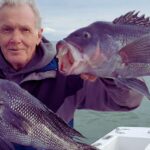
While everyone is chasing surface feeds and diving birds for stripers and bluefish, the rocky bottoms just outside the Branford River mouth are holding excellent numbers of Tautog. With the fall season opening, these hard-fighting bottom dwellers offer fantastic table fare and a rewarding challenge. Many anglers motor right past the best blackfish structure on their way to deeper water. Look for any submerged boulders, pilings, or breakwalls—if there are rocks and current, blackfish are likely home.
Baitfish Report
The estuary is currently loaded with peanut bunker (juvenile menhaden) and silversides. The peanut bunker are tightly schooled and frequently getting pushed to the surface by predatory fish, making them easy to identify. Silversides are holding tighter to the shoreline and marsh grass edges. You may also spot some adult bunker out deeper near the Long Island Sound transition.
TACTICAL STRATEGY
Where to Fish
Structure and current are the keys to unlocking the Branford River. Focus your efforts on the lower third of the river, specifically the current seams, eddies, and undercut banks where the water slows down. The rocky shoreline east of the river mouth is riddled with near-shore structure that holds fish on a moving tide. Position your boat or wade carefully near the deeper holes on the river bends, casting up-current and letting your presentation sweep naturally into the strike zone. If you are targeting Tautog, anchor precisely over the rock piles just outside the channel markers—being off by even a few feet can mean the difference between non-stop action and a skunking.
Lure and Bait Selection
For Striped Bass feeding on peanut bunker, a 4-inch to 5-inch soft plastic paddletail on a 1/2-ounce jig head is deadly. White, pearl, and chartreuse are the top producing colors in clear water. If fish are actively breaking the surface, switch to a walk-the-dog topwater plug like a Zara Spook or a Jumpin' Minnow in bone color.
If you prefer bait fishing for stripers, live eels fished on the bottom during the night tides or fresh chunked bunker during the day will draw strikes from larger fish. Remember that inline circle hooks are mandatory when fishing with bait for striped bass.
For Tautog, Asian shore crabs or green crabs cut in half are the only baits you need. Fish them on a simple single-hook bottom rig or a 3/4-ounce to 1-ounce tog jig (green or orange) depending on the current speed.
Pro Tip: When fishing topwater lures for fall stripers, do not stop your retrieve if a fish swirls and misses. Keep the cadence steady or speed it up slightly to mimic a fleeing, panicked baitfish. Stopping the lure often causes the fish to lose interest.
Timing the Bite
Tide is everything in a tidal river. The best action for Striped Bass is occurring during the last two hours of the incoming tide and the first two hours of the outgoing tide. This moving water flushes bait out of the marsh grasses and creates predictable ambush points for predators. Dawn and dusk remain the prime windows, especially when they overlap with a moving tide.
Pro Tip: Tautog feed almost exclusively during daylight hours and prefer a moderate current. Plan your blackfish trips for mid-day when the tide is moving, but avoid the absolute peak of the tide if the current is so strong that you cannot hold bottom with your rig.
REGULATIONS SNAPSHOT
Connecticut Department of Energy and Environmental Protection (CT DEEP) enforces strict regulations to protect local fisheries. Please ensure you have a valid Marine Waters Fishing License if you are over the age of 16.
Species
Size Limit
Bag Limit
Special Rules
Striped Bass
28 inches to less than 31 inches (Slot)
1 per angler/day
Inline circle hooks required with bait. No spearing or gaffing.
Bluefish
No minimum size
3 per angler/day
None
Tautog (Blackfish)
16 inches minimum
3 per angler/day (Fall Season)
Check exact CT DEEP fall opening dates.
REGIONAL ALTERNATIVE
If the wind is howling out of the south or southwest, making the mouth of the Branford River unsafe or unfishable in a small vessel, pack up and head east to Niantic Bay or the Groton area. Launching at the Bayberry Lane boat ramp in Groton offers excellent protection from southerly winds, thanks to the geographic shield provided by Pine Island.
In this alternative zone, you can still target the exact same fall-run species. Look for Striped Bass and Bluefish pushing bait against the protected shorelines and coves. The water here is generally deeper closer to shore, so switching to heavier jigs or casting metal lures like a Kastmaster or Deadly Dick can help you reach fish holding deeper in the water column. The rocky structure around Pine Island is also a phenomenal backup spot for Tautog if your primary Branford rock piles are blown out.
Tight lines!
Editor's Choice: Must-Have Gear
FISHINGSIR Next-Gen Waterproof Chest Waders
★★★★★4.4 (7,370+ reviews)
2-Ply Tech: Upgraded nylon with 2.5x higher density than standard fabrics.
100% Waterproof: Lab-approved intrusion resistance with taped visible seams.
Ultra-Lightweight: Designed for all-day comfort while hunting or fishing.
As an Amazon Associate I earn from qualifying purchases. #ad
Loading forecast...
Live Fishing Conditions: Tides, Weather & Waves
Get real‑time tides, marine weather, swell and solunar activity for each spot so you know exactly when conditions line up for your best chance at a bite.
🎣
Branford River
Loading coordinates...
🌤️
WEATHER CONDITIONS
--°F
--°C
Loading...
🌡️
Feels Like--°F--°C
💧
Humidity--%
💨
Wind-- mph-- km/h
🧭
Direction--
📊
Pressure-- inHg-- hPa
☀️
UV Index--
🌊
MARINE CONDITIONS
🌊Wave Height
-- ft
-- m
Loading...
🧭Wave Direction
--°
Loading...
⏱️Wave Period
-- s
Loading...
📈Tide Status
-- ft
-- m
Loading...
🌙
LUNAR & SOLUNAR
🌕
Loading...
Illumination: --%
Major Period--:-- - --:----:-- - --:--
Minor Period--:-- - --:----:-- - --:--
🌅Sunrise--:--
🌇Sunset--:--
📅
24-HOUR FORECAST
Loading fishing conditions...
Fishing Spots Map
🎣
Book a Fishing Charter near Branford River Fishing Report Today 🎣
Local guides & charters. Verified captains, instant booking, best price guaranteed.
There was an error loading the map. Please try refreshing the page.
Info
Local Access & Facilities
Branford River: A Strategic Connecticut Fishery
The Branford River serves as a vital artery for anglers targeting the rich waters of the Long Island Sound and the Connecticut coastline. Situated in Branford, this waterway offers a mix of protected tidal river fishing and direct access to the open Sound. The topography here transitions from suburban shorelines to the rugged, rocky structure characteristic of New England, providing excellent habitat for striped bass and bluefish. Experienced skippers appreciate the river's navigational reliability compared to more exposed launch points along the coast.
The atmosphere surrounding the Branford River is distinctly nautical yet accessible, bridging the gap between a working harbor and a recreational haven. While the upper reaches offer quieter water for light tackle, the mouth of the river opens into a bustling maritime environment. The area is particularly noted for its proximity to diverse habitats, ranging from tidal wetlands to the deep structure of the Sound. Anglers here often target seasonal runs of migratory fish, while the nearby freshwater systems, such as Hop Brook Lake, are known for stocked trout populations.
For the serious angler, this location requires a tactical approach to logistics. While the river itself is the main draw, the surrounding infrastructure supports a wide range of fishing styles, from shore-based family outings to heavy-tackle charter operations. Understanding the specific launch protocols and facility locations is essential, as some amenities are spread across the greater New Haven and Middlesex County region rather than sitting directly on the riverbank.
Access & Getting There
Reaching the Branford River typically involves navigating the I-95 corridor, a major thoroughfare that runs parallel to the Connecticut coast. Traffic congestion around New Haven can be significant, particularly during summer weekends and rush hours. Seasoned captains know to plan their arrival times carefully to avoid the bottlenecks often found near the I-95 and I-91 interchange. For those heading to the Stewart B. McKinney National Wildlife Refuge access points, the route involves taking Exit 64 to Route 145, offering a scenic but slower drive through Westbrook.
Boat launch availability fluctuates based on the tide and season. The data indicates multiple boat ramps within a 2 to 5-mile radius of the central spot, alongside designated shore access points suitable for families. When trailering a vessel, be aware that local ramps can be busy during the "dawn patrol" hours. The Salt Meadow Unit of the Wildlife Refuge serves as a key regional access point, located approximately 17 miles east, providing a gateway for those looking to explore the more protected, natural stretches of the coastline.
💡 Captain's Tip: Bait Logistics
Local bait shops are not located directly on the water. With the nearest major outfitter, HOOK’EM ALL OUTDOORS, located nearly 24 miles away in Berlin, you must stock up on fresh bunker, eels, or ice before you reach the launch ramp.
Parking requires a strategic approach, especially for those meeting charter crews or utilizing overflow lots. The nearest major parking facilities are located approximately 6.5 miles away in New Haven, such as Lot 59 on Orange Street and the Union Station Garage. These locations are open 24 hours, making them viable options for crew members carpooling from the city. However, they are not suitable for boat trailers. Always verify trailer parking availability at the specific local ramp you intend to use.
Branford River Pre-Trip Checklist
Facilities & Amenities
The infrastructure surrounding Branford River is robust but decentralized. Anglers will not find a "one-stop-shop" marina village directly at every access point; instead, services are spread across neighboring towns. For heavy gear and specialized tackle, the region relies on destination shops like HOOK’EM ALL OUTDOORS. While distant, this shop is highly rated for its selection. It is critical to note the lack of immediate on-site tackle vendors, meaning self-reliance is key for terminal tackle and emergency repairs.
The charter fleet operating in this sector of the Sound is well-regarded for its professionalism. Operators like FlyingConnie Fishing Charters in Clinton and Reel Cast Charters in Old Saybrook service this fishery. These outfits are known for their local knowledge of the Sound's ledges and rips. While they are based 14 to 23 miles east, they frequently work the waters accessible from the Branford area. The table below details key facilities for planning your logistics.
Facility Name
Type
Distance
Details
FlyingConnie Fishing Charters
Charter
14.1 miles
Clinton, CT. Rated 5 stars. Opens 5:00 AM.
Reel Cast Charters
Charter
23.4 miles
Old Saybrook, CT. Rated 5 stars. Opens 5:00 AM.
HOOK’EM ALL OUTDOORS
Bait & Tackle
24.0 miles
Berlin, CT. Open late (until 12:00 AM).
Union Station Garage
Parking
6.6 miles
New Haven, CT. Open 24 Hours.
Lot 59
Parking
6.5 miles
New Haven, CT. Open 24 Hours.
For anglers planning multi-day excursions, lodging options range from campgrounds to mobile home parks. Western Sands Mobile Home Park in Wallingford and Singh Estates in Clinton offer proximity within 13 miles. For a more rustic experience, the Youth Camping Site E in Chester provides camping facilities. Note that there are no fuel docks explicitly listed in the immediate river data, so topping off your tanks at highway stations like the one near Cycle Gear in Orange is a prudent move.
💡 Captain's Tip: Traffic Management
The I-95 corridor near New Haven is a notorious choke point. If you are trailing a boat, aim to clear the city limits before 6:00 AM or after 7:00 PM to avoid stop-and-go traffic that can overheat transmissions.
Permits, Regulations & Fees
Fishing in the Branford River and the surrounding Long Island Sound falls under the jurisdiction of the State Fishing Agency. Compliance with state licensing is mandatory for both freshwater and saltwater angling. The area includes sensitive ecological zones, most notably the Stewart B. McKinney National Wildlife Refuge. This refuge is a critical habitat for threatened species such as the piping plover and the endangered roseate tern.
Access to refuge lands is strictly regulated to protect these nesting birds. The refuge encompasses over 1,000 acres of forest, shrubland, and barrier beach. While boating and wildlife viewing are encouraged, visitors must adhere to specific "Kapu" or restricted zones during nesting seasons. Disturbing these habitats can result in significant fines and federal penalties. Always check the current refuge maps for closed areas before beaching a vessel or hiking near the shoreline.
Freshwater anglers heading inland to Hop Brook Lake should be aware that the lake and its feeder streams are periodically stocked with brown, brook, and rainbow trout by the CT DEEP. Fishing here is a popular activity, but standard state freshwater regulations regarding creel limits and seasons apply. There are generally no user fees to enter the Hop Brook Lake park, but picnic shelters may require reservations.
Events & Seasonal Information
The fishing calendar in this region is defined by the seasonal migration of game fish and local weather patterns. Spring brings the arrival of striped bass into the river mouths and harbors, while summer sees a peak in boating activity that can churn up the water by midday. The Hop Brook Lake area is a hub for summer recreation, including swimming and picnicking, which can crowd the water; early morning or late evening is the best time for productive freshwater casting.
Wildlife viewing peaks during the migration seasons in the Atlantic Flyway. The Stewart B. McKinney NWR offers exceptional opportunities to spot songbirds, wading birds, and shorebirds. For anglers who double as naturalists, the presence of osprey and bald eagles in the area can also serve as excellent indicators of baitfish schools. Winter offers opportunities for cross-country skiing at regional parks, while the hardier anglers target holdover fish in the tidal rivers.
💡 Captain's Tip: Wind Awareness
The afternoon sea breeze in Long Island Sound can kick up a steep chop against an outgoing tide at the river mouth. Small skiffs should plan to return to the ramp before the wind opposes the current in the late afternoon.
Contact Information & Resources
For the most current information on access and conditions, anglers should consult the managing agencies directly. The Stewart B. McKinney National Wildlife Refuge headquarters can be reached at 860-399-2513 or via email at shaun_roche@fws.gov. For inquiries regarding Hop Brook Lake, contact the project office at 203-729-8840.
Safety is paramount when fishing these tidal waters. Conditions can change rapidly, and self-reliance is necessary as patrol assets may be distant. Always file a float plan and ensure your safety gear is up to date. For precise locations, real-time conditions, and detailed boat ramp maps, consult the live dashboard and interactive maps below.
Our spot reports combine data-driven forecasts with curated local information. The forecast is generated by our proprietary Fishing Score algorithm (0–100%), which analyzes real-time data from Open-Meteo API, validated against NOAA CO-OPS tide gauges and USGS water-monitoring stations. The model weights tide dynamics (35%), wave energy (25%), wind patterns (20%) and time of day (20%)—factors shown to influence fish feeding behavior through marine-biology research and decades of charter log data.
Access, facilities and services information for each fishing spot is sourced from official datasets such as Recreation.gov (RIDB), state park & wildlife agencies, and geospatial providers like Google Maps. These sections undergo scheduled re-validation every 3–6 months to ensure that boat ramps, park access, contact details and local services remain accurate.
Narrative sections (catches, seasonal behavior, local tips) are synthesized from these data sources and refined following the Fishing Reports Today editorial guidelines, combining bibliographic research from ichthyology and oceanography with expert angler experience. Our team reviews reports on a regular basis, while the forecast model itself updates every 6 hours for real-time accuracy.
⚠️ Important: Always verify current local regulations, access restrictions and weather conditions before fishing. These reports are intended as a planning aid, not a guarantee of catches or safety. When in doubt, contact local authorities or park managers listed on the page.
To provide the best experiences, we use technologies like cookies to store and/or access device information. Consenting to these technologies will allow us to process data such as browsing behavior or unique IDs on this site. Not consenting or withdrawing consent, may adversely affect certain features and functions.
Functional Always active
The technical storage or access is strictly necessary for the legitimate purpose of enabling the use of a specific service explicitly requested by the subscriber or user, or for the sole purpose of carrying out the transmission of a communication over an electronic communications network.
Preferences
The technical storage or access is necessary for the legitimate purpose of storing preferences that are not requested by the subscriber or user.
Statistics
The technical storage or access that is used exclusively for statistical purposes.The technical storage or access that is used exclusively for anonymous statistical purposes. Without a subpoena, voluntary compliance on the part of your Internet Service Provider, or additional records from a third party, information stored or retrieved for this purpose alone cannot usually be used to identify you.
Marketing & Affiliates
The technical storage or access is required to create user profiles to send advertising, or to track the user on a website or across several websites for similar marketing purposes, including affiliate tracking for products recommended in our reports.




Leave a Reply