
The waters surrounding Coney Island and the broader New York Harbor entrance represent one of the most dynamic, high-structure fisheries on the East Coast. This is not a quiet backwater; it is a bustling, industrial intersection where the Atlantic Ocean pushes hard against the Hudson River outflow, creating a nutrient-rich environment that attracts serious game fish. For the expert angler, this location offers a unique blend of urban intensity and raw tidal power. You are fishing in the shadow of the Verrazzano-Narrows Bridge, navigating currents that rip through the Narrows, all while managing the heavy vessel traffic of one of the world's busiest ports.
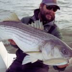
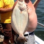
The atmosphere here is defined by the juxtaposition of the concrete jungle and the wild Atlantic. To the south and east, you have the open exposure of the New York Bight; to the north, the protected but swift-moving waters of the Upper Bay. The bottom topography is a complex mix of dredged channels, sandy shoals, and glacial moraine rock piles, particularly near the Staten Island shoreline at Fort Wadsworth. This structure holds massive schools of baitfish, which in turn draw the region's heavy hitters: Striped Bass, Bluefish, and Fluke.
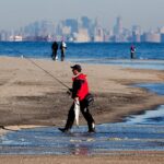
Seasoned captains know that success here relies on mastering the tides. The water movement through the Narrows acts as a conveyor belt for bait, and the game fish set up ambushes behind the bridge pilings and along the channel edges. Whether you are surf casting from the authorized beaches at Gateway National Recreation Area or launching a center console for a run toward Sandy Hook, the logistics of fishing this urban archipelago require precise planning and local intelligence.
Access & Getting There
Accessing the Coney Island and Fort Wadsworth fisheries requires navigating the complex artery of New York City's highway system. The primary approach for anglers heading to the Staten Island side is via the Verrazzano-Narrows Bridge. If you are coming from Brooklyn, seasoned locals know to take the lower level of the bridge if possible and stay to the far right. This positions you perfectly for the Bay Street exit immediately after the toll. Traffic on the Belt Parkway and the Staten Island Expressway (Interstate 278) is a constant variable; a 5:00 AM departure can mean the difference between a clear run and a two-hour delay.
For those targeting the Fort Wadsworth area, vehicular access is strictly controlled. After taking the Bay Street exit, you must proceed to the park entrance where the NPS guard booth is located. Parking is available at the Camp Gateway Ranger Station (Building #220). It is critical to note that this parking is generally reserved for campers and permitted visitors. Unlike suburban boat ramps with acres of trailer parking, the urban footprint here is tight. You must check in upon arrival. If you are accessing the fishery via the Knapp Street area in Brooklyn—home to charters like Gypsea Fishing Charters—street parking and local marina lots are the norm, and they fill rapidly during the striper run.
💡 Captain's Tip: Bridge Logistics
When crossing the Verrazzano-Narrows Bridge with a trailer or high-profile rod rack, always opt for the upper level if the lower level is closed, but be aware of wind restrictions. In high winds, the bridge authority may restrict trailer traffic, forcing a massive detour through New Jersey.
Public transportation is a viable option for surf casters traveling light, a rarity in most serious fishing destinations. The S51 bus from the Staten Island Ferry Terminal drops you right at the park entrance on Bay Street. However, for the boat angler, the logistical challenge is the launch. The data indicates limited immediate trailer launch facilities directly at Coney Island. Most private boaters utilize the marinas in Sheepshead Bay or travel south to Gateway National Recreation Area access points. The U.S. Coast Guard - Station New York is listed as a reference point for the area, but this is a federal facility and not for public recreational launching.
Weather contingencies are vital in this exposed harbor. When the wind blows against the tide in the Narrows, the sea state can become steep and dangerous in minutes. The accessible shorelines at Fort Wadsworth and Coney Island face south/southeast. During a strong southerly blow, the surf builds quickly, making surf casting challenging and boating uncomfortable. In these conditions, savvy anglers retreat inside the harbor toward Governors Island or the leeward side of Staten Island to find fishable water.
Coney Island, NY Pre-Trip Checklist
Facilities & Amenities
The infrastructure around Coney Island and Gateway National Recreation Area is robust but fragmented. You will not find a centralized "fishing village" but rather distinct hubs of activity. For bait and tackle, the immediate vicinity of the park is underserved. The data highlights I&L Bait & Tackle in Broad Channel, approximately 10 miles away, and Keyport Bait and Tackle across the bay in New Jersey. This means you must purchase your eel, clam, or bunker before you cross the bridge or arrive at the beach. Showing up to the Fort Wadsworth gate expecting to buy ice and bait on-site is a rookie mistake.
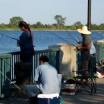
The charter fleet in this region is world-class, concentrated largely around the Knapp Street and Sheepshead Bay areas of Brooklyn, just a few miles east of the central Coney Island spot. Gypsea Fishing Charters and Hunter Fishing operate out of this hub. These vessels are known for their heavy-duty rail fishing for striped bass and blackfish (tautog). They are rigged for the heavy currents of the harbor and the rough water of the New York Bight. Across the bay in Highlands, NJ, Jenna P Sportfishing offers access to the same waters from the southern approach.
💡 Captain's Tip: Fuel Management
There are no fuel docks listed directly at the Camp Gateway or Fort Wadsworth waterfront. If you are trailing a boat, fuel up at highway stations on Route 1 or the Staten Island Expressway before entering the park roads. On the water, the nearest fuel is often miles away in Great Kills or Brooklyn.
For anglers looking to stay overnight close to the action, Camp Gateway - Staten Island offers a unique, albeit rustic, experience. Located at Fort Wadsworth, this campground provides a "dawn patrol" advantage that is unbeatable. You are sleeping within walking distance of the shoreline. However, the facilities are specific: this is tent camping only. There are no electrical outlets, meaning you cannot charge trolling motor batteries or run onboard fridges overnight. The sites (specifically H1, H2, H4, H6, H7) are rated as "Prime" for their location but offer full sun and no shade. You must bring your own shelter and cooling solutions.
Camp Gateway Facility Specs
| Feature | Details |
|---|---|
| Camping Type | Tent Only (No RVs, No Electric) |
| Amenities | Flush Toilets (Seasonal), Showers (Seasonal), Picnic Tables, Grills |
| Site Exposure | Full Sun (No Shade) - View of Verrazzano Bridge |
| Check-In/Out | Check-in: 12:00 PM / Check-out: 10:00 AM |
| Capacity | Max 4 People / 1 Vehicle per site |
Regarding parking for non-campers, the data lists several commercial lots, but they are at significant distances (e.g., SmartPark JFK is nearly 12 miles away). For immediate access, rely on the Camp Gateway Ranger Station lot if you have a reservation, or street parking in the adjacent neighborhoods of Staten Island, paying close attention to municipal signs.
Permits, Regulations & Fees
Fishing in the New York Harbor complex falls under a dual regulatory framework involving both New York State and Federal jurisdictions. First and foremost, all anglers aged 16 and older must possess a valid New York State Marine Fishing Registry. This is the baseline requirement for any saltwater fishing in the state.
However, accessing the prime shoreline spots within the Gateway National Recreation Area—which includes Fort Wadsworth, Sandy Hook, and Jamaica Bay—often requires the specific Gateway NRA Fishing Access Permit. The data explicitly identifies this permit as a facility type. This permit is not just a formality; it allows for after-hours parking and access to specific fishing areas that are otherwise closed to the general public after dark. Without this permit, you are restricted to daylight hours and general visitor parking areas, which puts you out of position for the prime night tides.
💡 Captain's Tip: The Night Bite
The biggest Striped Bass in the harbor often feed at night. To legally park and fish the Gateway NRA shorelines after sunset, the Fishing Access Permit is mandatory. Rangers patrol these lots strictly, and "I didn't know" will not prevent a ticket or eviction.
Cultural and historical respect is paramount here. Fort Wadsworth is one of the oldest military installations in the nation, with batteries like Battery Weed guarding the harbor. These are protected cultural resources. Climbing on historic fortifications to get a better casting angle is strictly prohibited and disrespectful to the site's heritage. Additionally, the waters around the Verrazzano-Narrows Bridge and U.S. Coast Guard Station have strict security zones. Boaters must maintain proper distances from bridge pilings and military vessels; heed all security broadcasts on VHF Channel 16.
Events & Seasonal Information
The rhythm of the fishery here is dictated by the migration of Striped Bass. The season typically ignites in the spring as fish move up the coast and into the Hudson River to spawn, passing directly through the Narrows. A second, often heavier run occurs in the fall as fish exit the estuaries and head south. This fall run is famous for "blitz" conditions where acres of surface water churn with feeding fish, visible from the Fort Wadsworth overlook.
Camping and facility availability at Camp Gateway are strictly seasonal. The visitor center and campground operate primarily from June through October, with extended weekend hours in the shoulder seasons of May and November. Note that the flush toilets and showers are seasonal; early spring or late fall anglers camping here should be prepared for limited amenities. The Fort Wadsworth Visitor Center itself is open Wednesday through Sunday during the peak season.
Governors Island National Monument, located further into the harbor, is another seasonal hub. While primarily a venue for art and culture, it is accessible by ferry and offers unique shore access points. However, it is generally open to the public only during the warmer months, and ferry schedules dictate your arrival and departure, making it less suitable for dedicated dawn-to-dusk fishing excursions compared to the 24-hour access potential of the outer beaches.
Contact Information & Resources
For the most current information regarding access, closures, and permits, direct contact with the managing agencies is essential. The primary agency for the fishing grounds discussed is the National Park Service via the Gateway National Recreation Area.
- Gateway National Recreation Area (Staten Island Unit): 718-354-4606
- Camp Gateway - Staten Island Office: 718-354-4655
- Fort Wadsworth Visitor Center: 718-354-4530
- National Parks of New York Harbor: 917-731-1997
- Governors Island National Monument: 212-825-3054
In an emergency on the water, the U.S. Coast Guard monitors VHF Channel 16. Given the heavy commercial traffic in the Ambrose Channel and the Narrows, maintaining a listening watch on the radio is critical for safety. For campers and shore anglers, be aware that bus service inside Fort Wadsworth stops at 7:00 PM daily, so plan your exit strategy accordingly if you are not driving.
For precise locations of the boat ramps, bait shops, and real-time wind conditions in the Narrows, consult the live dashboard and interactive maps below.

Leave a Reply