0%

Block Island Fishing Report Today 🎣

9 months ago Β· Updated 1 week ago

GO/NO-GO STATUS

Verdict: GO.

As we transition into the early summer fishing patterns, Block Island is officially firing on all cylinders. The current seasonal conditions are prime, with inshore water temperatures climbing steadily into the low to mid-60s. This warming trend has triggered a massive influx of migratory predators. Weather patterns are generally stabilizing, offering excellent crossing windows from Point Judith. However, the Block Island Sound is notoriously unpredictable; always monitor the marine forecast for sudden southwest winds that can stand the tide up and create treacherous swells over the ledges. If the wind speed stays below 15 knots, you have a green light to experience some of the most dynamic saltwater fishing on the East Coast.

SPECIES INTEL

Primary Target: Striped Bass

The spring migration is at its absolute peak, transforming the waters surrounding this teardrop-shaped island into a world-class striper haven. We are seeing an incredibly healthy mix of fish, ranging from aggressive school-sized bass to true 40-plus-pound cow stripers. Because the island sits perfectly in the epicenter of the Atlantic migratory route, cooler ocean waters sustain this bite long after the shallow mainland estuaries have grown too warm. The fish are aggressively ambushing bait pushed up against the island's rocky shoreline, submerged ledges, and dynamic rips.

🎣 Nautrek
Private Beta
J
M
R
100+ anglers on the waitlist

The fishing network where your reputation matters.

Find trusted captains, join real trips with cost splitting, and build your Angler Rank. Your spots stay private — you decide who sees your intel.

✓ Verified anglers ✓ Real trips ✓ Spot privacy
Join the Waitlist — Free →

No spam. First 500 get founder perks.

Nautrek App

Sleeper Pick: Summer Flounder (Fluke)

While the majority of the fleet is distracted by the chaotic topwater striper blitzes, the bottom fishing is quietly becoming spectacular. Heavy "doormat" fluke are beginning to stack up in the 60 to 70-foot depths, intercepting bait that gets swept off the shallower shoals. If you want to put high-quality meat in the cooler, dedicate a few hours to dragging the bottom.

Baitfish Report

The local waters are currently choked with massive, dense clouds of sand eels. This is the primary forage driving the inshore bite right now. Additionally, we are tracking significant pushes of adult menhaden (pogies) and squid holding near the deeper reef edges and drop-offs. Matching these specific bait profiles is the critical key to consistent success.

TACTICAL STRATEGY

Where to Deploy

To intercept trophy striped bass, focus your efforts on the North Rip and Southwest Ledge. The North Rip is a dynamic sandbar where the currents of Long Island Sound collide with the open Atlantic. Position your vessel well up-tide of the main bar and allow the current to sweep you naturally over the drop-off. For bottom-dwelling fluke and black sea bass, steam over to the West Grounds. This unique, pork-chop-shaped plateau is located roughly 3.5 nautical miles west of Grace Point. Geologically, it is a raised piece of ancient sea bottom that once linked Long Island to Block Island thousands of years ago. Today, it offers fantastic hard bottom and rocky structure in the 45 to 60-foot depths, creating a perfect ambush zone for flatfish and sea bass. The tidal current here can reach 1.6 knots, so plan your drifts carefully to maintain contact with the bottom.

Lure and Color Selection

When the bass are keyed in on sand eels, you must match the hatch. Rig slender soft plastics on 1-ounce jigheads. DuraTech eels and Joe Baggs Miracle Minnows are currently producing violent, rod-bending strikes. For the topwater enthusiasts, casting large pencil poppers and walk-the-dog stickbaits into the wash will draw explosive, heart-stopping surface hits. Water clarity around the island is exceptionally high right now, so stick to natural, translucent profiles. Pearl, bone, and olive-over-white are non-negotiable staples for imitating sand eels. If the fish grow finicky under a high sun, bubblegum pink is an incredible change-up color that often triggers aggressive reaction strikes.

Bait Tactics

If you are specifically hunting for a personal best cow striper, live bait is the undisputed king. Three-way rigging live eels or drifting live menhaden near the treacherous bottom structure of Southwest Ledge is the proven tactic for giants. Keep your baits tight to the boulders, but keep your drag locked down. You must be prepared to muscle these powerful fish away from the structure immediately after the strike, or they will break you off in the rocks. Remember that Southwest Ledge extends into federal waters where striped bass fishing is strictly prohibited, so monitor your GPS carefully to stay within the three-mile state boundary.

Timing the Bite

In these waters, tidal flow dictates the feed. The ebb (outgoing) tide at the North Rip is currently the most productive window, sparking the most aggressive and sustained feeding frenzies. Target the low-light conditions at dawn and dusk to extend your topwater bite, mask your leader, and avoid the midday boat traffic.

Pro Tip: When fishing the gin-clear waters around Block Island, predators can be incredibly line-shy. Always upgrade your terminal tackle to a 40lb to 50lb premium fluorocarbon leader, especially when casting soft plastics into the shallow boulder fields.

Pro Tip: At the North Rip, boat positioning is everything. Do not blast through the feeding zone with your outboard. Idle well up-tide on the edges, cut the engine, and let the natural current carry you silently over the sandbar drop-off to avoid spooking the school.

Pro Tip: If the striped bass are swirling on your topwater plugs but refusing to commit, they are likely fixated on tiny sand eels. Downsize your presentation immediately to a 7-inch soft jerkbait to perfectly match the local forage.

REGULATIONS SNAPSHOT

Understanding and respecting local marine regulations is paramount for conservation. Always verify with the Rhode Island Department of Environmental Management (DEM) before your trip, as mid-season adjustments frequently occur.

SpeciesMinimum SizeBag LimitSpecial Notes
Striped BassCheck current RI slot limit (typically 28" to <31")1 per angler/dayCircle hooks are mandatory when using bait.
Summer Flounder (Fluke)19 inchesCheck RI DEM for daily bagMeasure total length.
Black Sea Bass16.5 inches (Private/Shore)2 per angler/day (Early Season)Bag limit increases later in the season.

REGIONAL ALTERNATIVE

Editor's Choice: Must-Have Gear

FISHINGSIR Next-Gen Waterproof Chest Waders

β˜…β˜…β˜…β˜…β˜… 4.4 (7,370+ reviews)
  • 2-Ply Tech: Upgraded nylon with 2.5x higher density than standard fabrics.
  • 100% Waterproof: Lab-approved intrusion resistance with taped visible seams.
  • Ultra-Lightweight: Designed for all-day comfort while hunting or fishing.
Check Availability on Amazon

βœ“ Amazon's Choice | 100+ bought last month

πŸ›’ Tactical Gear for this Spot

Bandit Walleye Deep

Mandatory for reaching deep schools in 35-50ft mud flats.

Check Price on Amazon #ad

As an Amazon Associate I earn from qualifying purchases. #ad

Loading forecast...

Live Fishing Conditions: Tides, Weather & Waves

Get real‑time tides, marine weather, swell and solunar activity for each spot so you know exactly when conditions line up for your best chance at a bite.

🎣

Block Island

Loading coordinates...

🌀️

WEATHER CONDITIONS

Weather
-- Β°F
--Β°C

Loading...

🌑️
Feels Like --Β°F --Β°C
πŸ’§
Humidity --%
πŸ’¨
Wind -- mph -- km/h
🧭
Direction --
πŸ“Š
Pressure -- inHg -- hPa
β˜€οΈ
UV Index --
🌊

MARINE CONDITIONS

🌊 Wave Height
-- ft
-- m
Loading...
🧭 Wave Direction
--Β°
Loading...
⏱️ Wave Period
-- s
Loading...
πŸ“ˆ Tide Status
-- ft
-- m
Loading...
πŸŒ™

LUNAR & SOLUNAR

πŸŒ•

Loading...

Illumination: --%

Major Period --:-- - --:-- --:-- - --:--
Minor Period --:-- - --:-- --:-- - --:--
πŸŒ… Sunrise --:--
πŸŒ‡ Sunset --:--
πŸ“…

24-HOUR FORECAST

Loading fishing conditions...

Fishing Spots Map

🎣
Book a Fishing Charter near Block Island Fishing Report Today 🎣

Local guides & charters. Verified captains, instant booking, best price guaranteed.

See Available Trips β†’

My location
Loading map...

Local Access & Facilities

Situated approximately 12 miles offshore from the Rhode Island coastline, Block Island represents a distinct logistical challenge and a rewarding frontier for serious anglers. Unlike the accessible roadside spots of the mainland, this fishery sits squarely in the Atlantic flyway, acting as a biological magnet during migration seasons. The environment here is defined by its isolation; it is a rugged, wind-swept location where the North End meets the open ocean, creating a habitat that supports a massive concentration of wildlife.

The atmosphere on the island is far removed from the manicured marinas of Newport or the commercial bustle of Montauk. This is a place where nature dictates the schedule. The Block Island National Wildlife Refuge, located on the island's northern tip, serves as the primary access point for shore-bound anglers seeking to work the surf. For boaters, the island is a destination run, requiring a seaworthy vessel capable of handling the open waters of Block Island Sound.

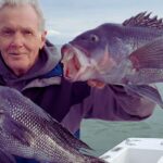
While the island is famous for its "cornucopia" of migratory songbirds in the fall, experienced watermen know that this biological richness extends below the surface. The convergence of currents around the island creates a dynamic feeding ground. Whether you are surf casting from the rocky shoreline of the refuge or navigating the rips offshore, success here requires careful planning, self-reliance, and a respect for the exposed nature of the location.

Access & Getting There

Reaching Block Island requires navigating a logistical bottleneck: the water separation. For those without their own keel, the primary artery is the ferry system departing from Point Judith in Narragansett. You will find the terminal via Route 108. Traffic on the mainland approaches can be heavy during summer weekends, so factor in significant buffer time to reach the ferry docks.

πŸ’‘ Captain's Tip: The Ferry Factor

If you plan to bring a vehicle to access the remote surf spots on the North End, reservations are not just recommendedβ€”they are mandatory. Call ahead well in advance, as vehicle slots fill up rapidly during the prime season.

Once you make landfall on the island, navigation is straightforward but limited. From the ferry terminal, turning right leads you toward the North End. A right turn at the first stop sign puts you on Corn Neck Road, which you will follow to its termination. This route leads directly to the parking lot for the Block Island National Wildlife Refuge. The terrain here transitions from paved roads to sandy paths, and you should be prepared to walk the beaches to reach the most productive water.

For anglers trailering their own vessels, the reality is that the launch likely happens on the mainland. The nearest major boat ramps and support facilities are located back in Narragansett or Charlestown, roughly 13 to 15 miles away across open water. There are no heavy-duty public launch facilities listed directly on the island's immediate perimeter in the provided data. This makes the crossing a significant commitment; ensure your vessel is equipped for changing weather conditions in the Sound.

Block Island State Airport offers an alternative entry point for those flying in. Located on Center Road, the airport provides 24-hour parking capabilities. While less common for heavy gear transport, it remains a viable option for anglers looking to scout the area or meet a charter that has already made the crossing.

Block Island Pre-Trip Checklist

Facilities & Amenities

The infrastructure on Block Island is geared more towards general tourism and conservation than heavy, specialized sportfishing support. A critical review of the local amenities reveals a "pack-in, pack-out" necessity. Most specialized bait and tackle shops are located on the mainland. Anglers should provision fully before boarding the ferry or launching their center consoles.

πŸ’‘ Captain's Tip: Mainland Provisioning

Do not rely on finding specialized tackle or fresh bait once you land. The nearest comprehensive shops, such as Breachway Bait & Tackle, are over 14 miles away in Charlestown. Stock up on ice, fuel, and terminal tackle before leaving the mainland.

For those running charters or looking to hire a guide, the fleet that services this area is top-tier but largely based in neighboring harbors. High-rated operations like Fishing Machine Charters depart from Narragansett (14.8 miles away), while the heavy hitters like Gina Ann Fishing Charters and Crunch Time Sport Fishing run out of Montauk (20+ miles away). These captains are accustomed to the long run and the specific conditions of the island's waters.

Parking on the island is available but specific. The Parking for the Staircase on Spring Street offers access near the bluffs, roughly 1.3 miles from the town center. If you are staging from the mainland, Blue Shutters Beach Private Parking in Charlestown provides a secure spot for your vehicle while you fish the coast or launch for the crossing. The table below details the available parking and support facilities in the region:

Facility NameTypeDistance / LocationNotes
Block Island State Airport ParkingParking1.2 miles (On Island)Open 24 hours daily. Reliable paved parking.
Parking for the StaircaseParking1.3 miles (On Island)Rated 4.7/5. Good access point for shore walkers.
Breachway Bait & TackleBait & Tackle14.5 miles (Charlestown)Opens 7:00 AM. Key stop for bait before crossing.
Westlake Bait & Tackle ShopBait & Tackle21.0 miles (Montauk)Opens 5:00 AM. Ideal for the Montauk fleet.
Weekapaug Bait and TackleBait & Tackle15.3 miles (Westerly)Opens 8:00 AM. Solid regional option.

Permits, Regulations & Fees

Fishing activities on and around Block Island are managed by the State Fishing Agency of Rhode Island. While the Block Island National Wildlife Refuge does not currently require a specific federal permit for entry or fishing ("permit_required: null"), anglers must adhere strictly to state licensing requirements. There are no entrance fees listed for the refuge itself, but the logistical costs of ferries or fuel make this a premium destination.

The Refuge, established in 1973 and expanded to 134 acres, is a sensitive ecological zone. It is managed as part of the Rhode Island National Wildlife Refuge Complex. The area is designated for wildlife viewing, photography, and environmental education alongside fishing. Because this is a federal refuge, "Kapu" (restrictions) regarding habitat destruction are strictly enforced. Do not trample dune grass or disturb nesting areas, particularly the gull colonies, which are the largest in Rhode Island.

Shore access is primarily through the refuge lands on the North End. The beach is walkable, but respect private property boundaries adjacent to the refuge. If you are fishing from a boat, be aware of the state water boundaries, especially if you are running from Montauk (New York waters) into Rhode Island waters, as regulations and size limits can differ across state lines.

Events & Seasonal Information

The biological rhythm of Block Island is dominated by the fall migration. The island is internationally recognized as a critical stopover in the Atlantic flyway. In the autumn, young, inexperienced songbirds "overfly" the mainland and concentrate here before correcting their course. For the angler, this intense biological activity often coincides with the fall run of predatory fish, as the water cools and bait presence increases.

πŸ’‘ Captain's Tip: The Fall Run

The arrival of over 70 species of migratory birds in the fall is a strong indicator of seasonal change. As the bird activity peaks, expect the surf fishing conditions to heat up at the North End. Plan your trips for late September through October to capitalize on this window.

Summer brings a different energy, characterized by heavier boat traffic and tourism. The ferry schedules are fuller, and the waters around the island can be busy with recreational cruisers. Early morning "dawn patrol" starts are essential during these months to secure parking at the refuge or to beat the boat traffic to the prime drifts. The refuge is open for wildlife viewing and photography year-round, offering a quiet alternative to the summer crowds if the bite slows down.

Contact Information & Resources

For the most current information regarding access conditions, refuge rules, or seasonal closures, direct your inquiries to the Rhode Island National Wildlife Refuge Complex. They are headquartered at the Kettle Pond Visitor Center in Charlestown, RI.

  • Refuge Phone: (401) 364-9124
  • Email: RhodeIslandcomplex@fws.gov
  • Headquarters Address: 50 Bend Road, Charlestown, RI 02813

Safety is paramount when fishing an offshore island. Cell service can be spotty on the remote North End beaches. Always file a float plan if boating over from the mainland, and carry appropriate safety gear for open water crossings. For precise locations, real-time weather conditions, and detailed charts of the surrounding waters, consult the live dashboard and interactive maps below.

🎣

Block Island

New Shoreham β€’ Rhode Island β€’ 41.1721, -71.5585
πŸ…ΏοΈ

Parking

5
Block Island State Airport Parking
⭐ 5.0 1.2 mi
πŸ“ 4 Center Rd, New Shoreham, RI 02807, USA
πŸ•’
Monday: Open 24 hours
Tuesday: Open 24 hours
Wednesday: Open 24 hours
Thursday: Open 24 hours
Friday: Open 24 hours
Saturday: Open 24 hours
Sunday: Open 24 hours
πŸš— Get Directions
Blue Shutters Beach Private Parking
⭐ 5.0 13.7 mi
πŸ“ 469 E Beach Rd, Charlestown, RI 02813, USA
πŸš— Get Directions
Parking for the Staircase
⭐ 4.7 1.3 mi
πŸ“ Spring St, New Shoreham, RI 02807, USA
πŸš— Get Directions
Dunes Park Beach
⭐ 4.6 15.2 mi
πŸ“ 665 Atlantic Ave, Westerly, RI 02891, USA
πŸ•’
Monday: 8:30β€―AM – 5:30β€―PM
Tuesday: 8:30β€―AM – 5:30β€―PM
Wednesday: 8:30β€―AM – 5:30β€―PM
Thursday: 8:30β€―AM – 5:30β€―PM
Friday: 8:30β€―AM – 5:30β€―PM
Saturday: 8:30β€―AM – 5:30β€―PM
Sunday: 8:30β€―AM – 5:30β€―PM
πŸš— Get Directions
🐟

Bait & Tackle

5
Westlake Bait & Tackle Shop
⭐ 5.0 21.0 mi
πŸ“ 352 W Lake Dr, Montauk, NY 11954, USA
πŸ•’
Monday: 5:00β€―AM – 7:00β€―PM
Tuesday: 5:00β€―AM – 7:00β€―PM
Wednesday: 5:00β€―AM – 7:00β€―PM
Thursday: 5:00β€―AM – 7:00β€―PM
Friday: 5:00β€―AM – 7:00β€―PM
Saturday: 5:00β€―AM – 7:00β€―PM
Sunday: 5:00β€―AM – 7:00β€―PM
πŸš— Get Directions
Breachway Bait & Tackle
⭐ 5.0 14.5 mi
πŸ“ 166 Charlestown Beach Rd, Charlestown, RI 02813, USA
πŸ•’
Monday: 7:00β€―AM – 6:00β€―PM
Tuesday: 7:00β€―AM – 6:00β€―PM
Wednesday: 7:00β€―AM – 6:00β€―PM
Thursday: 7:00β€―AM – 6:00β€―PM
Friday: 7:00β€―AM – 6:00β€―PM
Saturday: 7:00β€―AM – 6:00β€―PM
Sunday: 7:00β€―AM – 6:00β€―PM
πŸš— Get Directions
Weekapaug Bait and Tackle
⭐ 4.9 15.3 mi
πŸ“ 664 Atlantic Ave, Westerly, RI 02891, USA
πŸ•’
Monday: 8:00β€―AM – 4:00β€―PM
Tuesday: 8:00β€―AM – 4:00β€―PM
Wednesday: 8:00β€―AM – 4:00β€―PM
Thursday: 8:00β€―AM – 4:00β€―PM
Friday: 8:00β€―AM – 4:00β€―PM
Saturday: 8:00β€―AM – 4:00β€―PM
Sunday: 8:00β€―AM – 4:00β€―PM
πŸš— Get Directions
Montauk Anglers Club & Marina
⭐ 4.9 20.4 mi
πŸ“ 467 E Lake Dr, Montauk, NY 11954, USA
πŸ•’
Monday: 8:00β€―AM – 4:00β€―PM
Tuesday: 8:00β€―AM – 4:00β€―PM
Wednesday: 8:00β€―AM – 4:00β€―PM
Thursday: 8:00β€―AM – 4:00β€―PM
Friday: 8:00β€―AM – 4:00β€―PM
Saturday: Closed
Sunday: Closed
πŸš— Get Directions
🚀

Fishing Charters

4
ArchAngel Fishing Charters
⭐ 5.0 24.1 mi
πŸ“ Fort Adams Dr, Newport, RI 02840, USA
πŸ•’
Monday: Open 24 hours
Tuesday: Open 24 hours
Wednesday: Open 24 hours
Thursday: Open 24 hours
Friday: Open 24 hours
Saturday: Open 24 hours
Sunday: Open 24 hours
πŸš— Get Directions
Gina Ann Fishing Charters of Montauk
⭐ 5.0 21.0 mi
πŸ“ 352 W Lake Dr, Montauk, NY 11954, USA
πŸ•’
Monday: Open 24 hours
Tuesday: Open 24 hours
Wednesday: Open 24 hours
Thursday: Open 24 hours
Friday: Open 24 hours
Saturday: Open 24 hours
Sunday: Open 24 hours
πŸš— Get Directions
Crunch Time Sport Fishing Charters Montauk
⭐ 5.0 20.8 mi
πŸ“ 59 Star Island Rd, Montauk, NY 11954, USA
πŸ•’
Monday: Open 24 hours
Tuesday: Open 24 hours
Wednesday: Open 24 hours
Thursday: Open 24 hours
Friday: Open 24 hours
Saturday: Open 24 hours
Sunday: Open 24 hours
πŸš— Get Directions
Fishing Machine Charters
⭐ 5.0 14.8 mi
πŸ“ State St, Narragansett, RI 02882, USA
πŸ•’
Monday: Open 24 hours
Tuesday: Open 24 hours
Wednesday: Open 24 hours
Thursday: Open 24 hours
Friday: Open 24 hours
Saturday: Open 24 hours
Sunday: Open 24 hours
πŸš— Get Directions
🏠

Lodging

5
Camp Hero Picnic Area
⭐ 5.0 18.1 mi
πŸ“ 347F+2P, Camp Hero State Pk, Montauk, NY 11954, USA
πŸš— Get Directions
Camp Richard
⭐ 4.9 18.0 mi
πŸ“ 15 Lauri Dr, Charlestown, RI 02813, USA
πŸš— Get Directions
βš“

Boat Ramps

3
🚻

Restrooms

3
πŸ‘¨β€πŸ‘©β€πŸ‘§β€πŸ‘¦

Family Friendly

2
β™Ώ

Accessibility

β™Ώ

Wheelchair Access

Not Confirmed

πŸ•

Pets Allowed

Not Confirmed

⚠️ Some accessibility info not officially confirmed. Please verify with location directly.

πŸ“ Showing 27 facilities on map
🎣
Book a Fishing Charter near Block Island Fishing Report Today 🎣

Local guides & charters. Verified captains, instant booking, best price guaranteed.

See Available Trips β†’

πŸ“Š

About Our Fishing Reports & Forecasts

Our spot reports combine data-driven forecasts with curated local information. The forecast is generated by our proprietary Fishing Score algorithm (0–100%), which analyzes real-time data from Open-Meteo API, validated against NOAA CO-OPS tide gauges and USGS water-monitoring stations. The model weights tide dynamics (35%), wave energy (25%), wind patterns (20%) and time of day (20%)β€”factors shown to influence fish feeding behavior through marine-biology research and decades of charter log data.

Access, facilities and services information for each fishing spot is sourced from official datasets such as Recreation.gov (RIDB), state park & wildlife agencies, and geospatial providers like Google Maps. These sections undergo scheduled re-validation every 3–6 months to ensure that boat ramps, park access, contact details and local services remain accurate.

Narrative sections (catches, seasonal behavior, local tips) are synthesized from these data sources and refined following the Fishing Reports Today editorial guidelines, combining bibliographic research from ichthyology and oceanography with expert angler experience. Our team reviews reports on a regular basis, while the forecast model itself updates every 6 hours for real-time accuracy.

⚠️ Important: Always verify current local regulations, access restrictions and weather conditions before fishing. These reports are intended as a planning aid, not a guarantee of catches or safety. When in doubt, contact local authorities or park managers listed on the page.

Learn more about our methodology & data sources β†’

Leave a Reply

Your email address will not be published. Required fields are marked *