0%

Apache Lake, AZ Fishing Report Today 🎣

4 months ago · Updated 2 weeks ago

Apache Lake Fishing Report - January 18, 2026

1. GO/NO-GO STATUS

Status: CAUTION - LOGISTICAL ADVISORY

The Verdict: Fishing conditions are excellent, but getting a boat to the water requires strict adherence to navigation rules. The "Fish Creek Hill" section of SR 88 (Apache Trail) between mileposts 222 and 227 is restricted to high-clearance 4x4 vehicles only. NO TRAILERS are permitted on this stretch.

  • Boat Towing Access: You MUST access Apache Lake from the east via Roosevelt Lake (Highway 188 to SR 88). Do not attempt to tow a boat from Apache Junction/Tortilla Flat.
  • Water Conditions: Lake levels are high (~95% full), offering great cover but requiring precise boat control near submerged brush.
  • Weather: Highs in the mid-60s, lows in the 40s. Mornings are crisp; dress in layers. No ice issues.

2. SPECIES INTEL

Based on citizen science observations and current seasonal patterns:

SpeciesActivity LevelBiological Notes
Smallmouth Bass
(Primary Target)
HighWinter is prime time for big bronzebacks on Apache. They are holding deep on rocky structure, metabolically slowed but willing to eat an easy meal.
Rainbow Trout
(JSON Verified)
Moderate/HighVerified Presence: Recent observations in the Salt River system confirm trout are active. Stockers are cruising shorelines and marina areas looking for insect hatches or dough bait.
Yellow Bass
(Sleeper Pick)
Very HighOften overlooked, "Yellows" school tightly in winter. If you find one, you find a hundred. Great for filling a cooler.

Baitfish Report: Threadfin Shad are the primary forage. In winter, they die off or become lethargic in cold water snaps. Bass are looking for dying shad fluttering down the water column.

3. TACTICAL STRATEGY

Smallmouth Bass: The Deep Finesse Game

  • Where: Focus on Main Lake Points and Steep Rock Walls near the Horse Mesa Dam end. Look for the 15-25 ft depth range where rock transitions to gravel.
  • Lure: Ned Rig or Drop Shot.
    • Ned Rig: 1/10 oz mushroom head with a TRD in "Green Pumpkin" or "Canada Craw".
    • Drop Shot: 3/16 oz tungsten weight, size 1 hook, nose-hooking a 4.5" straight tail worm.
  • Color: Morning Dawn (pink/purple) is a legendary color on this chain for drop shots. Chartreuse/Pepper works well for jigs imitating crawfish.
  • Pro Tip: Fish slowly. Winter bass won't chase. Dead-stick your bait (let it sit motionless) for 5-10 seconds between movements.

Rainbow Trout: Shore & Troll

  • Where: Burnt Corral and the Marina Coves. Shore anglers should target the transition where sandy beaches meet rocky rip-rap.
  • Technique:
    • Trolling: Pull a Rapala J-5 Jointed (Silver/Black) or a small Kastmaster spoon on lead core line to get down 10-15 ft.
    • Shore: PowerBait (Garlic or Corn) on a slip sinker rig with a 24-inch leader.

Yellow Bass: Vertical Jigging

  • Where: Use sonar to find "clouds" of bait/fish in 25-40 ft of water near the river channel bends.
  • Lure: 1/2 oz Jigging Spoon (Hopkins or Kastmaster) in Gold or Silver.
  • Technique: Drop directly into the school. Snap the spoon up 1-2 feet and let it flutter down on a semi-slack line. Most hits happen on the drop.

4. REGULATIONS SNAPSHOT

Always verify with the 2026 AZGFD Fishing Regulations booklet before casting.

  • Bass (Largemouth/Smallmouth): Apache Lake often has a protected slot limit (typically no harvest between 13-16 inches). Catch-and-release is recommended to preserve this trophy fishery.
  • Rainbow Trout: Daily bag limit is usually 6 fish.
  • Yellow Bass: No limit. Anglers are encouraged to harvest these to manage the population.

5. REGIONAL ALTERNATIVE

If the road to Apache Lake is too daunting:

Canyon Lake (Downstream)

  • Access: Paved all the way via SR 88 from Apache Junction (before the unpaved closure).
  • Target: Trophy Largemouth Bass and stocked Rainbow Trout.
  • Tactic: Throw large swimbaits (Huddleston 68) near the buoy line for monster bass, or fish the Boulder Recreation Area for trout.

Tight lines!

Loading forecast...

Live Fishing Conditions: Tides, Weather & Waves

Get real‑time tides, marine weather, swell and solunar activity for each spot so you know exactly when conditions line up for your best chance at a bite.

🎣

Apache Lake, AZ

Loading coordinates...

🌤️

WEATHER CONDITIONS

Weather
-- °F
--°C

Loading...

🌡️
Feels Like --°F --°C
💧
Humidity --%
💨
Wind -- mph -- km/h
🧭
Direction --
📊
Pressure -- inHg -- hPa
☀️
UV Index --
🌊

MARINE CONDITIONS

🌊 Wave Height
-- ft
-- m
Loading...
🧭 Wave Direction
--°
Loading...
⏱️ Wave Period
-- s
Loading...
📈 Tide Status
-- ft
-- m
Loading...
🌙

LUNAR & SOLUNAR

🌕

Loading...

Illumination: --%

Major Period --:-- - --:-- --:-- - --:--
Minor Period --:-- - --:-- --:-- - --:--
🌅 Sunrise --:--
🌇 Sunset --:--
📅

24-HOUR FORECAST

Loading fishing conditions...

Fishing Spots Map

My location
Loading map...

Local Access & Facilities

Nestled deep within the Superstition Wilderness, Apache Lake represents a rugged, high-reward fishery for anglers willing to navigate the logistical challenges of the Salt River chain. Unlike its bustling neighbor Roosevelt Lake, this reservoir offers a more secluded experience, characterized by steep canyon walls, clear blue water, and a shoreline studded with iconic Saguaro cacti. The lake stretches 17 miles, making it the longest in the chain below Roosevelt Dam, providing ample structure for serious game fish hunters.

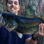
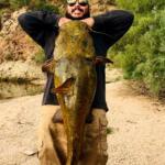
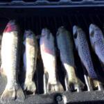
The primary draw here is the diverse bass fishery, featuring substantial populations of Largemouth and Smallmouth Bass that thrive in the deep, rocky topography. Beyond bass, the lake holds impressive numbers of Crappie, Sunfish, and massive Flathead and Channel Catfish that patrol the darker depths. The atmosphere is distinctly Sonoran Desert—stark, beautiful, and unforgiving regarding heat and exposure—demanding self-reliance from any captain planning a multi-day excursion.

💡 Captain's Tip: Seasonal Water Clarity

Apache Lake is known for its clear water conditions compared to other Salt River reservoirs. When targeting Smallmouth Bass along the rocky cliffs, downsize your line diameter and opt for natural fluorocarbon leaders to avoid spooking fish in the high-visibility water.

Access & Getting There

Reaching Apache Lake requires careful route planning, particularly for those towing varied vessel sizes. The most critical logistical detail for seasoned anglers is the current road status. The direct access to Burnt Corral from Tortilla Flat via AZ-88 East (The Apache Trail) is frequently closed due to washouts and maintenance. You must verify this before departure, as turning a trailer around on these narrow mountain roads is nearly impossible.

For reliable access, especially when trailering, the recommended route approaches from the Roosevelt Dam side. From the Mesa area, seasoned skippers head north on AZ-87 for approximately 59 miles, turning right onto AZ-188 South. After 31.6 miles, turn right onto AZ-88 West. Continue past the historic Roosevelt Dam for about 5 to 6 miles to reach the Burnt Corral Recreation Site. This route is paved but winding; ensure your trailer brakes are in top condition for the descent into the canyon.

The primary launch facility is at Burnt Corral Campground. The ramp here is paved and generally accessible, featuring a boat boarding dock that aids in solo launching. However, water levels in the Salt River chain fluctuate significantly based on agricultural demand and drought conditions. At lower water levels, the ramp can become steep and slick with algae. Parking at the ramp is available but limited during peak weekends; getting "dawn patrol" timing is essential not just for the bite, but for a slot for your trailer.

💡 Captain's Tip: The "Back Way" Warning

Do not trust standard GPS routing blindly. Access via the unpaved section of the Apache Trail (from Tortilla Flat) is often gated shut. Always route through Globe or via AZ-188 past Roosevelt Lake to avoid a mandatory U-turn with a boat trailer.

Apache Lake, AZ Pre-Trip Checklist

Facilities & Amenities

Infrastructure at Apache Lake is focused on camping and basic launch access rather than commercial marina services. The Burnt Corral Campground serves as the central hub for anglers. It offers 76 camp units, many of which accommodate boat trailers (up to 32 feet), though hookups are non-existent. The site provides potable water hydrants and vault toilets, but you should not expect luxury amenities. Shade is a premium commodity here; while some sites have shade ramadas, the surrounding Mesquite and Palo Verde trees offer only dappled relief from the midday sun.

For those requiring more extensive facilities, the Windy Hill Campground is located approximately 7.5 miles away on nearby Roosevelt Lake. Windy Hill is significantly larger, with 147 units, showers, and a fully accessible boat ramp. If Apache Lake's facilities are at capacity, Windy Hill serves as a strategic fallback location, allowing you to trailer over to Apache for day trips. Note that specialized gear shops are scarce in the immediate vicinity. The nearest data-listed bait supply is 188 Upholstery (which stocks bait) roughly 16.5 miles away in Tonto Basin. Serious anglers should arrive fully stocked with tackle, ice, and fuel.

Local Facility Overview

Facility NameTypeKey FeaturesDistance from Spot
Burnt Corral CampgroundAccess & CampingPaved Boat Ramp, Dock, 76 Campsites, Potable Water0.4 miles
Windy Hill CampgroundCampgroundShowers, Accessible Ramp, Fish Cleaning Station, 147 Sites7.5 miles
Frazier Horse CampgroundEquestrian CampCorrals, Vault Toilets (Near Roosevelt Dam)5.4 miles
Coyote Boat LaunchBoat LaunchTrailer Parking Available7.3 miles

💡 Captain's Tip: Fuel Management

There are no fuel docks directly accessible at the Burnt Corral launch. Top off your tanks in Globe or Tonto Basin before descending AZ-88. Running out of gas in the canyon usually means a long wait for a tow.

Permits, Regulations & Fees

Fishing Apache Lake requires adherence to Arizona Game and Fish Department regulations. A valid Arizona fishing license is mandatory for all anglers 10 years of age and older. The lake is managed in conjunction with the Tonto National Forest, and a Tonto Pass is typically required for parking and day-use at recreation sites like Burnt Corral and Windy Hill. These passes must often be purchased in advance at authorized vendors, as on-site kiosks may not always be reliable or present.

Anglers should be aware of the cultural and historical significance of the Tonto Basin. The area is rich in history, including the nearby Tonto National Monument, which preserves cliff dwellings of the Salado culture dating back to 1300 CE. While fishing, respecting the shoreline is critical; removing artifacts or disturbing archaeological sites is a federal offense. Additionally, "Kapu" or restricted areas may exist near sensitive wildlife habitats or dam infrastructure—always observe posted signage near Roosevelt Dam.

Events & Seasonal Information

The rhythm of Apache Lake is dictated by the desert seasons. Summer temperatures frequently exceed 100°F, making early morning and night fishing the standard for serious locals. During these months, recreational boat traffic (water skiers and wakeboarders) picks up significantly by 10:00 AM. Pros know to be off the main channel and working deep structure or coves by mid-morning to avoid the wake.

Winter and spring offer solitude and excellent fishing for Smallmouth Bass as the water cools. The lake is less prone to the violent wind shifts that plague the larger Roosevelt Lake, but the canyon walls can funnel winds during storms, creating choppy conditions rapidly. While there are no major professional tournaments exclusive to Apache Lake listed recently, the Salt River chain is a hotbed for regional bass clubs. Anglers should check local boards for club tournaments that might crowd the single launch ramp at Burnt Corral on spring weekends.

Contact Information & Resources

For the most current information regarding lake levels, fire restrictions, and road closures, direct contact with the managing agencies is recommended before hitching up the boat.

  • Managing Agency: Tonto National Forest - Tonto Basin Ranger District
  • Phone: (602) 225-5395
  • Nearby Cultural Site: Tonto National Monument - (928) 467-2241
  • Emergency: Dial 911 (Note: Cell service is spotty in the canyon; reliable signal is often found near the dam or higher elevations).

For precise locations of the boat ramps, real-time weather overlays, and detailed topography of the lake floor, consult the live dashboard and interactive maps below.

🎣

Apache Lake, AZ

Roosevelt • Arizona • 33.6221, -111.2071
🅿️

Parking

5
Coyote Boat Launch
⭐ 5.0 7.3 mi
📍 MWC4+2M, Roosevelt, AZ 85545, USA
🚗 Get Directions
Indian Point Boat Launch
⭐ 5.0 9.9 mi
📍 QQ77+FM, Tonto Basin, AZ 85553, USA
🚗 Get Directions
Salt River Wild Horse Viewing Parking
⭐ 5.0 20.0 mi
📍 Maricopa County, AZ 85264, USA
🕒
Monday: Open 24 hours
Tuesday: Open 24 hours
Wednesday: Open 24 hours
Thursday: Open 24 hours
Friday: Open 24 hours
Saturday: Open 24 hours
Sunday: Open 24 hours
🚗 Get Directions
Fish Creek Vista
⭐ 4.8 8.7 mi
📍 22019 AZ-88, Apache Junction, AZ 85119, USA
🕒
Monday: Open 24 hours
Tuesday: Open 24 hours
Wednesday: Open 24 hours
Thursday: Open 24 hours
Friday: Open 24 hours
Saturday: Open 24 hours
Sunday: Open 24 hours
🚗 Get Directions
🐟

Bait & Tackle

1
188 upholstery
⭐ 4.4 16.5 mi
📍 117 Quail Trail, Tonto Basin, AZ 85553, USA
🕒
Monday: 8:00 AM – 5:00 PM
Tuesday: 8:00 AM – 5:00 PM
Wednesday: 8:00 AM – 5:00 PM
Thursday: 8:00 AM – 5:00 PM
Friday: 8:00 AM – 5:00 PM
Saturday: Closed
Sunday: Closed
🚗 Get Directions
🏠

Lodging

4
Lost Dutchman State Park
⭐ 4.7 19.2 mi
📍 6109 N Apache Trail, Apache Junction, AZ 85119, USA
🕒
Monday: 6:00 AM – 5:00 PM
Tuesday: 6:00 AM – 5:00 PM
Wednesday: 6:00 AM – 5:00 PM
Thursday: 6:00 AM – 5:00 PM
Friday: 6:00 AM – 7:00 PM
Saturday: 6:00 AM – 7:00 PM
Sunday: 6:00 AM – 7:00 PM
🚗 Get Directions
Saguaro Lake Guest Ranch
⭐ 4.7 19.4 mi
📍 13020 N Bush Hwy, Mesa, AZ 85215, USA
🕒
Monday: 7:00 AM – 5:00 PM
Tuesday: 7:00 AM – 5:00 PM
Wednesday: 7:00 AM – 5:00 PM
Thursday: 7:00 AM – 5:00 PM
Friday: 7:00 AM – 5:00 PM
Saturday: 7:00 AM – 5:00 PM
Sunday: 7:00 AM – 5:00 PM
🚗 Get Directions
Box 8 Ranch
⭐ 4.7 24.4 mi
📍 226 S Smith Dr, Superior, AZ 85173, USA
🕒
Monday: 8:00 AM – 6:00 PM
Tuesday: 8:00 AM – 6:00 PM
Wednesday: 8:00 AM – 6:00 PM
Thursday: 8:00 AM – 6:00 PM
Friday: 8:00 AM – 6:00 PM
Saturday: 8:00 AM – 6:00 PM
Sunday: 8:00 AM – 6:00 PM
🚗 Get Directions

Boat Ramps

3
🚻

Restrooms

3
👨‍👩‍👧‍👦

Family Friendly

2

Accessibility

Wheelchair Access

Available

🐕

Pets Allowed

Not Confirmed

⚠️ Some accessibility info not officially confirmed. Please verify with location directly.

📍 Showing 19 facilities on map

📊

About Our Fishing Reports & Forecasts

Our spot reports combine data-driven forecasts with curated local information. The forecast is generated by our proprietary Fishing Score algorithm (0–100%), which analyzes real-time data from Open-Meteo API, validated against NOAA CO-OPS tide gauges and USGS water-monitoring stations. The model weights tide dynamics (35%), wave energy (25%), wind patterns (20%) and time of day (20%)—factors shown to influence fish feeding behavior through marine-biology research and decades of charter log data.

Access, facilities and services information for each fishing spot is sourced from official datasets such as Recreation.gov (RIDB), state park & wildlife agencies, and geospatial providers like Google Maps. These sections undergo scheduled re-validation every 3–6 months to ensure that boat ramps, park access, contact details and local services remain accurate.

Narrative sections (catches, seasonal behavior, local tips) are synthesized from these data sources and refined following the Fishing Reports Today editorial guidelines, combining bibliographic research from ichthyology and oceanography with expert angler experience. Our team reviews reports on a regular basis, while the forecast model itself updates every 6 hours for real-time accuracy.

⚠️ Important: Always verify current local regulations, access restrictions and weather conditions before fishing. These reports are intended as a planning aid, not a guarantee of catches or safety. When in doubt, contact local authorities or park managers listed on the page.

Learn more about our methodology & data sources

Leave a Reply

Your email address will not be published. Required fields are marked *