Bartlett Lake is currently offering phenomenal angling opportunities, but dynamic seasonal conditions require boaters to remain vigilant. Water releases from the Horseshoe Dam spillway upstream on the Verde River actively influence the reservoir's profile. This influx brings nutrient-rich water that sparks the food chain, but it also introduces heavy floating debris, including large logs and treacherous drift, concentrated in the upper sections of the lake near the river mouth and the Yellow Cliffs. If you are navigating north of the Bartlett Marina, keep your engine at idle speed and keep a sharp lookout.
Weather conditions are heating up swiftly, transitioning into classic desert warmth. Morning temperatures are incredibly comfortable, but midday heat demands ample hydration and sun protection. Additionally, the combination of rising water levels and seasonal algae growth has made the paved boat ramps, particularly around Bartlett Flat, exceptionally slick. Exercise extreme caution when backing trailers down the ramp, and ensure your tow vehicle is in four-wheel drive if equipped.
From the editor
Tired of fishing with strangers you can’t trust?
Nautrek is the first social network for serious anglers — verified partners, real trips, cost splitting and intel sharing without burning your spots. Private beta now open.
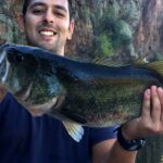
Largemouth bass are the undisputed kings of Bartlett Lake right now. The fishery is currently in a dynamic post-spawn transition. The larger female bass have abandoned their shallow spawning beds in the brushy coves and are aggressively corralling baitfish. These fish are moving from shallow flats to their early summer holding zones, suspending along secondary points, submerged roadbeds, and steep transition banks. They are highly active, making them incredibly susceptible to both reaction strikes and finesse presentations.
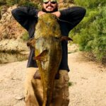
Sleeper Pick: Flathead Catfish
While the bass boats crowd the points, the true river monsters of Bartlett Lake are often completely ignored. The reservoir boasts a thriving, naturally reproducing population of massive flathead catfish, with specimens exceeding forty inches and thirty pounds caught regularly. These apex predators utilize the submerged timber and deep river channels as ambush points. They are highly predatory and prefer live forage over the traditional prepared stink baits used for channel cats.
Baitfish Report
The forage base is currently dominated by massive schools of threadfin and gizzard shad. You will visibly see these bait balls flickering on the surface during the early morning hours, particularly in the southern half of the lake where the water clarity is more stable. In addition to shad, juvenile bluegill and crawdads are heavily active in the rocky shallows, providing a secondary protein source for cruising bass.
TACTICAL STRATEGY
Where to Deploy
Because of the steep, rocky canyon walls that define Bartlett's bathymetry, horizontal presentations can sometimes fall short. Focus your efforts on the vertical bluff walls south of the Yellow Cliffs and the deep rocky points near the main lake basin adjacent to the dam. The water here remains clear and stable, avoiding the muddy turbidity found further up the Verde River inlet. Target the 12 to 20-foot depth zones where the bass are suspending just above the first major drop-off.
Pro Tip:When fishing the steep walls at Bartlett Lake, keep your boat positioned over deep water and cast parallel to the bluff lines. Allow your drop-shot rig to step down the rocky ledges naturally. This keeps your bait in the strike zone significantly longer than casting perpendicular to the bank.
Lure and Color Selection
Water clarity strictly dictates your exact presentation. In the clearer waters of the main lake basin, rely heavily on a 1/4-ounce drop-shot rig paired with a 4-inch finesse worm. Colors like Morning Dawn, Oxblood, and natural translucent shad patterns are absolute killers here. Use a light fluorocarbon leader, ideally 8-pound test, to prevent spooking line-shy fish.
If you venture further north into the stained water of the river arm, switch to a 3/8-ounce vibrating jig, such as a Chatterbait, in high-visibility white or chartreuse. Pair this with a matching paddle-tail swimbait trailer to maximize water displacement and help the bass track the lure in low-visibility conditions.
Bait and Timing
The golden hours are non-negotiable. Arrive at the ramp before dawn to capitalize on a vicious topwater bite. Throw walking baits, like a Zara Spook in a bone or chrome finish, over long points at the entrances to coves. Once the sun crests the canyon walls and hits the water, the topwater bite will die quickly. This is your cue to switch to the drop-shot or drag a 1/2-ounce football jig in a watermelon-pumpkin color scheme across the rocky bottom to mimic fleeing crawdads.
For the sleeper flathead catfish, target the submerged timber near the Tonto Creek inlet during the low-light hours of dusk or completely after dark. Use a heavy 3-way rig with a live bluegill (caught on-site where regulations permit) suspended just off the bottom.
Pro Tip:Do not ignore the seemingly featureless mud flats near the mid-lake coves. Examine the bank closely for subtle cuts and micro-channels. These small depressions run right out into the lake and serve as hidden highways for bass moving up to feed in the shallows.
REGULATIONS SNAPSHOT
Always ensure your licensing is up to date and that you have purchased the required Tonto National Forest Pass for parking and entry, as rangers actively patrol the recreation sites. The following regulations apply to Bartlett Lake under current Arizona Game and Fish Department (AZGFD) rules:
Species
Daily Bag Limit
Special Notes
Largemouth & Smallmouth Bass
6 (in any combination)
Statewide general regulations apply.
Crappie
15 (in any combination)
Specific Bartlett Lake limit exception.
Channel & Flathead Catfish
Unlimited
No bag or possession limit on Bartlett Lake.
REGIONAL ALTERNATIVE
If the massive water releases from Horseshoe Dam render the northern stretches of Bartlett Lake too muddy or clogged with debris to fish effectively, pivot your operation west to Lake Pleasant. Located roughly an hour away, Lake Pleasant offers a vastly different, yet equally productive, deep-water fishery.
Access the water via the 10-Lane Ramp or Castle Creek. Lake Pleasant is renowned for its aggressive striped bass and white bass populations. If you arrive early, look for massive surface boils as the stripers corral threadfin shad. Cast a 1/2-ounce white bucktail jig or a heavy chrome spoon directly into the frenzy and use a fast, erratic retrieve. When the sun gets high, use your electronics to locate submerged humps in 40 to 60 feet of water and drop heavy spoons vertically to schooling fish. The water clarity at Pleasant remains exceptionally clear, making it a reliable backup when river-fed reservoirs get blown out.
Tight lines!
Editor's Choice: Must-Have Gear
FISHINGSIR Next-Gen Waterproof Chest Waders
★★★★★4.4 (7,370+ reviews)
2-Ply Tech: Upgraded nylon with 2.5x higher density than standard fabrics.
100% Waterproof: Lab-approved intrusion resistance with taped visible seams.
Ultra-Lightweight: Designed for all-day comfort while hunting or fishing.
As an Amazon Associate I earn from qualifying purchases. #ad
Loading forecast...
Live Fishing Conditions: Tides, Weather & Waves
Get real‑time tides, marine weather, swell and solunar activity for each spot so you know exactly when conditions line up for your best chance at a bite.
🎣
Bartlett Lake
Loading coordinates...
🌤️
WEATHER CONDITIONS
--°F
--°C
Loading...
🌡️
Feels Like--°F--°C
💧
Humidity--%
💨
Wind-- mph-- km/h
🧭
Direction--
📊
Pressure-- inHg-- hPa
☀️
UV Index--
🌊
MARINE CONDITIONS
🌊Wave Height
-- ft
-- m
Loading...
🧭Wave Direction
--°
Loading...
⏱️Wave Period
-- s
Loading...
📈Tide Status
-- ft
-- m
Loading...
🌙
LUNAR & SOLUNAR
🌕
Loading...
Illumination: --%
Major Period--:-- - --:----:-- - --:--
Minor Period--:-- - --:----:-- - --:--
🌅Sunrise--:--
🌇Sunset--:--
📅
24-HOUR FORECAST
Loading fishing conditions...
Fishing Spots Map
🎣
Book a Fishing Charter near Bartlett Lake Fishing Report Today 🎣
Local guides & charters. Verified captains, instant booking, best price guaranteed.
There was an error loading the map. Please try refreshing the page.
Info
Local Access & Facilities
Bartlett Lake stands out in the Tonto National Forest as a premier desert fishery, offering a distinct alternative to the busier reservoirs in the Salt River chain. Fed by the Verde River, this location is characterized by its rugged Sonoran Desert surroundings, fluctuating water levels, and a mix of rocky shorelines and submerged vegetation. For the serious angler, the appeal lies in the diversity of the water; the main lake offers deep-water structure, while the northern river section provides a quieter, flowing water experience where fish are frequently seen jumping along the current.
The atmosphere here ranges from the high-energy activity near the main marina to the absolute solitude of the upstream river areas. Unlike the manicured urban lakes of Phoenix, Bartlett retains a raw, wild aesthetic with steep canyon walls and expansive flats that reveal themselves as water levels drop. It is a year-round destination, but seasoned captains know that the tranquility found here—especially in the non-motorized zones—is the true draw for those looking to escape the recreational boat traffic common on other Arizona waters.
While the lake is a known recreational hub, the logistical realities of fishing here require preparation. The distance from major supply chains means self-reliance is key. Whether you are launching a bass boat for a tournament run or hiking the banks of the Verde River for a quiet morning session, understanding the layout of the access points and the limitations of local infrastructure is essential for a successful trip.
Access & Getting There
Reaching Bartlett Lake involves a drive through the rolling desert terrain north of Phoenix. The primary route for anglers coming from Scottsdale or the Valley is via Cave Creek Road to Bartlett Dam Road. The drive is approximately 23 miles east of Carefree. Be advised that Bartlett Dam Road is a winding, two-lane paved road with significant elevation changes and tight curves; anglers towing heavy fiberglass boats should exercise caution, particularly during early morning hours when wildlife is active on the tarmac.
For those targeting the main body of water, the JoJoba Boating Launch and the main marina ramps are your primary entry points. These ramps are generally wide and serviceable, designed to handle substantial trailer traffic. However, the desert heat can make the asphalt scorching hot by mid-day, and low water levels can sometimes expose slick algae on the lower ramp sections. Traction is critical here.
💡 Captain's Tip: The Gravel Factor
If you are heading to the Riverside Campground for river access, note that just before the Jojoba site, the road (FR 19) turns into maintained gravel for the final 3 miles. While passable for most vehicles, protect your trailer hull from flying stones and check your tie-downs before hitting the washboard sections.
Parking capacity varies significantly by zone. The main launch areas offer designated trailer parking, but these lots fill rapidly on weekends. At the Riverside access point, there is a strict limit of three vehicles per campsite, and all vehicles must fit completely within the designated parking area. This area is strictly non-motorized for boats, making it the ideal launch point for kayak anglers or float tubes looking to work the river channel without fighting wake from powerboats.
Bartlett Lake Pre-Trip Checklist
Facilities & Amenities
Infrastructure at Bartlett Lake is functional but focused. The Bartlett Lake Marina serves as the logistical heart of the fishery. It is the only immediate source for fuel, basic tackle, and supplies on the water. The marina operates from 9:00 AM to 5:00 PM throughout the week. For serious captains, this means fueling up in town before a dawn patrol launch is mandatory, as the pumps will not be open for the early bite.
Accommodation for multi-day trips is primarily camping-based. Riverside Campground offers 12 sites and is a favorite for anglers who want to wake up directly on the water. However, this facility is "negative knowledge" territory: there is no potable water available here. You must pack in every drop of water you intend to use. Additionally, generators are prohibited during quiet hours (10:00 PM to 6:00 AM), so plan your battery charging and climate control accordingly.
💡 Captain's Tip: Digital Dead Zones
Cellular service is extremely limited or non-existent in the remote sections of the lake and river. Download the Recreation.gov mobile app and your offline maps before you leave Carefree. You will need the app to use the "Scan and Pay" feature at the campsite if you haven't bought a pass elsewhere.
For those requiring high-end amenities or heavy repairs, the nearest extensive services are back in Scottsdale or Rio Verde. WestWorld in Scottsdale (approx. 22 miles away) serves as a regional recreation anchor, but for immediate fishing needs, you are largely on your own once you pass the ranger station. Several high-end accommodations like the Four Seasons Resort Scottsdale and local ranches like Chaparosa Ranch are located 10 to 15 miles out, serving as comfortable base camps for those who prefer not to camp.
Facility Name
Type
Key Features
Distance
Bartlett Lake Marina
Bait/Fuel
Fuel dock, general store, boat rentals. Open 9am-5pm.
On-Site
Riverside Campground
Lodging/Access
Non-motorized launch, river access, no water, 12 sites.
Fishing and access at Bartlett Lake are governed by a mix of state and federal regulations. The area falls under the jurisdiction of the Tonto National Forest. A Tonto Pass is generally required for parking and entry at recreation sites. Passes can be purchased at the Tonto Fee Machine located at the Cave Creek Ranger Station on your way in. Do not ignore this; enforcement is active, and rangers patrol the lots regularly.
For campers at Riverside, the fee is $16 per site, per night. This is a first-come, first-served location with no reservations accepted. The "Scan and Pay" system via QR code is available on-site, but relies on the previously mentioned mobile app. A strict 14-day stay limit is enforced to prevent homesteading and ensure access for all anglers.
💡 Captain's Tip: The Motor Restriction
The Riverside area has a strict No Motor Boats regulation. This is not a "no wake" zone; it is an exclusion zone for combustion engines. If you are running a bass boat, stick to the main lake ramps (JoJoba or Marina). Riverside is exclusively for the paddle and wading crowd.
Glass containers are prohibited across these recreation sites. This rule is strictly enforced to protect the shoreline and the safety of visitors. Additionally, be aware of the "Kapu" or general respect for the land; while not explicitly marked as sacred in every corner, the Tonto National Forest contains sensitive archaeological sites. Tread lightly and pack out what you pack in.
Events & Seasonal Information
Bartlett Lake follows the rhythm of the desert seasons. Summer temperatures routinely exceed 100°F, making the "dawn patrol" and night fishing the only viable options for serious anglers. The water levels fluctuate based on releases from the Horseshoe Dam upstream and demands from the Bartlett Dam downstream. These fluctuations can drastically change the shoreline structure, exposing or hiding rock piles that hold fish.
While the lake itself hosts local bass tournaments, major regional events are often centered around the WestWorld complex in Scottsdale. Events like the Barrett-Jackson Auto Auction or Arabian Horse Shows can cause significant congestion on Pima Road and Frank Lloyd Wright Boulevard. Check the local event calendar if you plan to tow your boat through Scottsdale during peak season (winter/spring), as traffic delays can add an hour to your transit time.
Contact Information & Resources
For the most current conditions regarding water levels and fire restrictions, anglers should consult the Tonto National Forest authorities or the local marina. Safety in this environment is largely a matter of heat management and hydration. Always carry more water than you think you need, especially if hiking the banks near the river.
Bartlett Lake Marina: (480) 221-0503
WestWorld (General Area Info): (480) 312-6802
Emergency: 911 (Note: Cell service is spotty; satellite messengers are recommended for remote river areas).
For precise locations of the gravel road turn-offs, real-time weather data, and specific depth contours, consult the live dashboard and interactive maps below.
Our spot reports combine data-driven forecasts with curated local information. The forecast is generated by our proprietary Fishing Score algorithm (0–100%), which analyzes real-time data from Open-Meteo API, validated against NOAA CO-OPS tide gauges and USGS water-monitoring stations. The model weights tide dynamics (35%), wave energy (25%), wind patterns (20%) and time of day (20%)—factors shown to influence fish feeding behavior through marine-biology research and decades of charter log data.
Access, facilities and services information for each fishing spot is sourced from official datasets such as Recreation.gov (RIDB), state park & wildlife agencies, and geospatial providers like Google Maps. These sections undergo scheduled re-validation every 3–6 months to ensure that boat ramps, park access, contact details and local services remain accurate.
Narrative sections (catches, seasonal behavior, local tips) are synthesized from these data sources and refined following the Fishing Reports Today editorial guidelines, combining bibliographic research from ichthyology and oceanography with expert angler experience. Our team reviews reports on a regular basis, while the forecast model itself updates every 6 hours for real-time accuracy.
⚠️ Important: Always verify current local regulations, access restrictions and weather conditions before fishing. These reports are intended as a planning aid, not a guarantee of catches or safety. When in doubt, contact local authorities or park managers listed on the page.
To provide the best experiences, we use technologies like cookies to store and/or access device information. Consenting to these technologies will allow us to process data such as browsing behavior or unique IDs on this site. Not consenting or withdrawing consent, may adversely affect certain features and functions.
Functional Always active
The technical storage or access is strictly necessary for the legitimate purpose of enabling the use of a specific service explicitly requested by the subscriber or user, or for the sole purpose of carrying out the transmission of a communication over an electronic communications network.
Preferences
The technical storage or access is necessary for the legitimate purpose of storing preferences that are not requested by the subscriber or user.
Statistics
The technical storage or access that is used exclusively for statistical purposes.The technical storage or access that is used exclusively for anonymous statistical purposes. Without a subpoena, voluntary compliance on the part of your Internet Service Provider, or additional records from a third party, information stored or retrieved for this purpose alone cannot usually be used to identify you.
Marketing & Affiliates
The technical storage or access is required to create user profiles to send advertising, or to track the user on a website or across several websites for similar marketing purposes, including affiliate tracking for products recommended in our reports.


Leave a Reply