


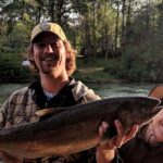
Chicken Canyon, NJ represents a distinct class of fishery that demands a shift in mindset from the typical shore-bound or nearshore angler. Located in the offshore waters off the New Jersey coast, this spot is defined not by its proximity to pavement or conveniences, but by its isolation and the specific submarine topography that attracts pelagic life. For the expert angler and seasoned captain, the appeal here lies in the challenge of the environment itself. The coordinates place this location well beyond the sight of land, in a realm where the blue water dictates the terms of engagement. It is a destination that requires precise navigation and a vessel capable of handling the open Atlantic.
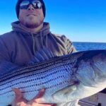
The atmosphere at these coordinates is strictly utilitarian and wild. Unlike a manicured harbor or a bustling pier, the "vibe" here is generated by the rhythmic swell of the ocean and the solitude of the open water. The environment is characterized by deep water conditions, where the bottom structure influences the water column, creating upwellings and temperature breaks that are critical for locating target species. Anglers heading to this location are not looking for amenities; they are looking for the raw biological productivity that occurs at specific offshore waypoints. The primary focus here is on the pursuit of game fish that roam these pelagic zones, requiring heavy tackle and significant preparation.
Success at Chicken Canyon is measured by logistical preparation as much as fishing skill. Because this is an open-water location, the "facility" is effectively the boat you arrive on. There are no breakwaters to hide behind and no immediate refuges from a sudden squall. The narrative of this location is written in fuel burn rates, weather windows, and the reliability of your electronics. It is a spot for those who have graduated from the bay and are ready to commit to the serious undertaking of offshore fishing, where self-reliance is the only rule that matters.
💡 Captain's Tip: Weather Windows
Given the offshore location at 39.8733° N, weather is the single most critical factor for access. Never rely on a single forecast model; cross-reference wind and wave height predictions specifically for the offshore zones, as conditions here often differ significantly from the immediate coastline.
Access & Getting There
Reaching Chicken Canyon, NJ is an exercise in navigation and seamanship rather than a simple drive to a trailhead. Situated at coordinates 39.8733° N, -73.0583° W, this location is accessible solely by seaworthy vessels capable of prolonged offshore operation. There are no roads, bridges, or ferries that service this specific waypoint. The "commute" involves a significant run from the mainland, requiring captains to plot a direct course from their respective inlets along the New Jersey coast. Traffic routes here are defined by shipping lanes and other recreational vessels, so maintaining a sharp watch on radar and AIS is essential during transit, especially in low-light conditions.
The "Launch Reality" for this spot is unique because the launch point is entirely dependent on the angler's home port. Whether departing from northern or southern New Jersey ports, the journey requires calculating fuel consumption with a heavy safety margin. There are no bottlenecks in the traditional sense of traffic jams, but "bottlenecks" occur in the form of sea conditions. A confused sea state or opposing wind and tide can double transit times, turning a manageable run into a grueling endurance test for crew and gear. Captains must be intimately familiar with their vessel's cruising speed and range to ensure a safe return trip.
Weather contingencies are the primary governor of access to these coordinates. The open Atlantic offers no protection from winds, regardless of direction. While a west wind might flatten the nearshore waters, it can still produce significant chop 40 to 50 miles out. Conversely, an east wind or "nor'easter" can make the area dangerous and unfishable. Experienced skippers know that access is effectively closed when wave heights exceed the operational safety limits of their specific vessel. The strategy here is patience; waiting for a stable high-pressure system is often the difference between a productive trip and a dangerous one.
Since there is no physical parking or land at the spot, "parking" strategy refers to boat positioning. Drifting or trolling are the standard modes of operation. When setting up a drift, captains must account for the prevailing current and wind to ensure the vessel moves naturally over the target structure without tangling lines. In crowded conditions, which can occur when the bite is hot, proper spacing and adherence to the "rules of the road" are vital to prevent crossed lines and frayed tempers. Security is not about locking car doors, but about securing gear on deck; anything not lashed down during the transit to 39.8733° N is liable to be lost or damaged.
💡 Captain's Tip: Navigation Safety
Always program the specific coordinates 39.8733, -73.0583 into your primary and backup GPS units before leaving the dock. In the event of an electronics failure, having these numbers written on a physical chart is a prudent backup strategy.
Chicken Canyon, NJ Pre-Trip Checklist
Facilities & Amenities
It is critical for anglers to understand that Chicken Canyon, NJ possesses absolutely zero physical facilities. There are no fuel docks, no bait shops, no restrooms, and no fresh water sources at the location itself. This is a wilderness area in the truest sense. The "amenities" are strictly limited to what is carried on board. This "Negative Knowledge" is vital for planning: if you do not bring ice, you will not have ice. If you run low on fuel, there is no floating station to assist you. The nearest help is miles away back on the mainland.
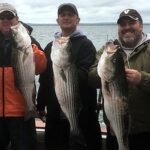
Because of this lack of infrastructure, the "Go-To Shop" is effectively the tackle shop you visit on land before departure. Anglers must ensure they are fully stocked with specific terminal tackle, fresh bait, and backup gear. The caliber of the "fleet" found at these coordinates is generally high, consisting of sportfishing yachts, center consoles, and seasoned charter boats. These vessels are equipped for self-sufficiency, often carrying redundant communication systems, life rafts, and extensive medical kits. The presence of such a fleet indicates the serious nature of the fishery.
Lodging logistics are irrelevant at the spot itself but are highly relevant for the night before the trip. Anglers traveling to the coast to access this offshore canyon often stay in motels or rentals near their departure inlet to facilitate a "dawn patrol" or pre-dawn departure. The goal is to be at the fishing grounds by first light, which often necessitates leaving the dock well before sunrise. Therefore, finding accommodation with trailer parking (if towing) and close proximity to the marina is a key logistical consideration on the mainland.
Regarding specialized gear, since there are no rental shops at sea, anglers must own or charter heavy-duty equipment suitable for deep-water applications. The absence of amenities emphasizes the need for a comprehensive pre-trip checklist. Every clamp, crimp, and leader must be accounted for prior to casting off lines. The isolation of the spot dictates that mechanical reliability and gear integrity are the only safety nets available.
💡 Captain's Tip: Self-Reliance
With no facilities on site, ensure your vessel carries ample fresh water and a comprehensive tool kit. Minor mechanical issues that are annoyances at the dock can become emergencies at 39.8733° N.
Permits, Regulations & Fees
Fishing at Chicken Canyon, NJ falls under the jurisdiction of regional and state authorities. According to the provided data, regulations in this area are managed by the State Fishing Agency. It is imperative that all anglers and captains are fully licensed and aware of the current laws before wetting a line. The "Why" behind these regulations is rooted in the conservation of marine resources. Sustainable management ensures that the pelagic ecosystems remain viable for future generations of anglers. Ignorance of the law is never a valid defense, especially when federal or state enforcement vessels conduct offshore patrols.
While the data does not indicate specific "protected zones" or marine sanctuaries directly overlaying these coordinates, users must always check for temporary closures or seasonal restrictions. The State Fishing Agency frequently updates size limits, bag limits, and gear restrictions based on scientific assessments of fish stocks. It is common for specific species to have strict retention limits or catch-and-release requirements. Anglers should consult official state sources and digital regulation apps for the most up-to-date information on what can be legally harvested.
Cultural respect and ethical angling practices are also paramount. While there may not be physical "Kapu" signs in the ocean, the unwritten rules of offshore etiquette apply. This includes respecting the space of other vessels, not cutting across trolling patterns, and properly disposing of trash. The ocean environment is sensitive to pollution; nothing should be thrown overboard that isn't biodegradable. Furthermore, ethical handling of catch-and-release species ensures a higher survival rate, contributing to the overall health of the fishery.
There are no direct "entrance fees" to access the ocean at these coordinates, but the costs are sunk into state licensing and potential federal permits depending on the target species (such as Highly Migratory Species permits, often required for offshore trips). Captains should verify if their vessel requires a specific permit to fish in federal waters, as the distance from shore often crosses jurisdictional boundaries between state and federal control.
Events & Seasonal Information
The rhythms of Chicken Canyon are dictated entirely by the seasons and the migratory patterns of marine life. The "event" calendar here is not written by a chamber of commerce but by water temperature charts and bait movement. Generally, the fishing activity peaks during the warmer months when water temperatures rise, bringing pelagic species within range. Winter months often see the area become inaccessible due to frequent storms and hazardous sea states, making it a seasonal fishery for most recreational vessels.
While specific tournaments are not listed in the data, offshore canyons off the New Jersey coast are often the playing fields for major summer fishing tournaments. During these competitive windows, the area can see an increase in vessel traffic. Anglers should be aware that during peak tournament season, the "best spots" on the structure may be crowded. The timing of the bite can also vary; some species feed aggressively at dawn, while others may turn on with a tide change or a shift in wind direction.
The best time of day to fish is invariably influenced by the weather patterns mentioned in the safety notes. Early mornings often offer the calmest seas before the afternoon thermal winds pick up. Seasoned captains monitor the barometer and wind forecasts to time their arrival and departure, aiming to maximize fishing time during the safest and most comfortable windows. Understanding the seasonal interplay between wind, current, and water temperature is the key to unlocking the potential of this location.
Contact Information & Resources
For regulatory inquiries and licensing verification, anglers should contact the State Fishing Agency. This agency is the primary authority on rules, seasons, and catch limits for the area. It is advisable to have their contact information or website accessible for quick reference regarding legal changes.
Safety is the ultimate responsibility of the vessel captain. In the event of an emergency at 39.8733° N, -73.0583° W, standard VHF radio protocols should be followed. The isolation of the spot means that self-rescue or assistance from nearby good Samaritans is often the fastest response. Always inform a shore-based contact of your float plan, including your destination coordinates and expected return time. As noted in the safety data, always "check weather and ocean conditions before fishing" and ensure all crew members "wear appropriate footwear and sun protection."
For precise locations, real-time conditions, and to explore the surrounding bathymetry, consult the live dashboard and interactive maps below.
Leave a Reply