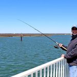
Summer fishing is in full swing around Stone Harbor, and the current conditions are highly favorable for both back-bay drifters and nearshore reef bouncers. Water temperatures have warmed up beautifully, activating the metabolism of our primary target species and pushing baitfish deep into the estuarine systems. Anglers should exercise standard seasonal caution regarding afternoon pop-up thunderstorms, which can build rapidly over the mainland and push eastward toward the barrier islands with little warning. Additionally, be highly mindful of the outgoing tide at Townsends Inlet; when a strong ebb tide meets a stiff onshore wind, the mouth of the inlet can stack up with steep, confused, and dangerous chop. If you are running a smaller center console or skiff, time your inlet transits during slack water or the incoming tide for a much smoother and safer ride.
Species Intel
Primary Targets
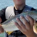
Summer Flounder (Fluke): Flounder are currently the most abundant and active species in the area. They have fully settled into their summer holding patterns in the back bays and salt marshes, while larger "doormat" sized fish are beginning to stack up on the nearshore artificial reefs just off the coast.
🎣Nautrek
Private Beta
J
M
R
100+ anglers on the waitlist
The fishing network where your reputation matters.
Find trusted captains, join real trips with cost splitting, and build your Angler Rank. Your spots stay private — you decide who sees your intel.
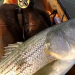
Striped Bass: The local surf is producing excellent numbers of Striped Bass. While many of the massive migratory cows have pushed further north for the season, there is a very healthy population of resident fish and late-migrating schoolies patrolling the troughs and sandbars just off the beaches.
Black Sea Bass: The nearshore wrecks and reefs are absolutely carpeted with Black Sea Bass. They are voracious and aggressive right now, making them an excellent target to fill the cooler before the mid-summer regulation changes throttle back the allowable bag limits.
Sleeper Pick
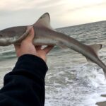
Triggerfish and Sheepshead: Most visiting anglers are so focused on Fluke and Sea Bass that they completely ignore the structure-oriented exotics moving into the region. As the water warms, Triggerfish and Sheepshead are taking up residence on the concrete culverts and sunken vessels of the local artificial reefs. They put up a spectacular, wrist-straining fight on light tackle and are phenomenal on the dinner table.
Baitfish Report
The back bays are currently teeming with peanut bunker (juvenile menhaden), spearing (silversides), and small spot. In the surf zone, sand fleas (mole crabs) are highly active, and larger bunker schools are periodically pushing past the outer sandbars. Matching your presentation to this abundant, specific forage is the key to unlocking a consistent bite.
Tactical Strategy
Where to Target
For back-bay Flounder, focus your efforts on the quiet marsh channels behind Stone Harbor, specifically targeting the 8 to 12-foot drop-offs near the 96th Street Bridge and the sod bank edges of the Intracoastal Waterway. The Fluke will lie in ambush on the slopes of these channels, waiting for the tide to sweep baitfish over their heads.
If you are heading out to the ocean, the Townsends Inlet Reef is the premier destination. Located roughly 3.8 nautical miles from the inlet, this compact, 0.52-square-mile reef is a literal fish factory. Despite its small size, it features depths ranging from 40 to 70 feet and is loaded with dredge rock, reef balls, and sunken vessels like the 82-foot trawler Donna's Star. Drift the edges of the dredge rock for Fluke, or use your trolling motor to spot-lock directly over the concrete culverts for Black Sea Bass and Triggerfish.
Lure & Color Selection
Your tackle box should be prepped with specific presentations tailored to the local forage. Here is the breakdown for our primary targets:
Flounder (Back Bays): Ditch the heavy tackle and use a 1/2-ounce to 3/4-ounce white or glow bucktail jig, tipped with a 6-inch Gulp! Grub. Chartreuse, Pink Shine, and Nuclear Chicken are the top producing colors in the slightly stained water of the marshes. Tie a dropper loop 18 inches above the bucktail and add a teaser hook with a smaller 4-inch Gulp! Swimming Mullet.
Black Sea Bass (Reefs): When fishing the reef, drop an AVA-17 or AVA-27 diamond jig in a chrome or silver finish. If the fish are finicky, switch to a standard high-low bottom rig dressed with small squid skirts in glow or pink.
Striped Bass (Surf): If you prefer throwing artificials in the suds, pack a selection of 1 to 2-ounce bucktails, rubber shads, and classic swimming plugs. Bone white or yellow patterns are excelling in the low-light hours.
Pro Tip: When drifting the back bays for Fluke, your drift speed is critical. If the wind and tide are pushing you faster than 1.5 knots, deploy a drift sock to slow your presentation. Fluke are ambush predators and will not chase a bait that is zooming past them at warp speed.
Bait Recommendations
For Striped Bass in the surf, fresh or salted clam bellies fished on a fish-finder rig are outproducing everything else. Use a 4 to 6-ounce pyramid sinker to hold bottom in the sweep, and ensure you are using an 8/0 inline circle hook. If you are targeting doormat Fluke on the nearshore reefs, live spot or peanut bunker hooked lightly through the upper lip are absolute candy to trophy-sized flatfish. For the sleeper Triggerfish and Sheepshead, bring a bucket of green crabs or white leggers, crack the shells slightly to release the scent, and fish them tight to the reef structure.
Pro Tip: When fishing clams in the surf, use elastic bait thread to secure the soft clam belly to your circle hook. This prevents the bait from flying off during a hard cast and keeps the smaller nuisance fish from easily stripping your hook before a Bass finds it.
Timing the Bite
In the back bays, the absolute best window is the last two hours of the incoming tide and the first hour of the outgoing. The incoming ocean water brings a flush of clean, cool, oxygenated water that triggers a heavy feeding response from Flounder. For surfcasting Stripers, dawn and dusk remain the golden hours, especially when those low-light periods align with a moving tide.
Regulations Snapshot
Please note that current New Jersey marine regulations are strictly enforced. Always measure your catch accurately on a flat board with the mouth closed and the tail pinched.
Species
Minimum Size
Bag Limit
Season & Notes
Summer Flounder (Fluke)
18 inches
3 fish per angler
Standard marine waters. Note: Delaware Bay has a special 17-inch minimum.
Striped Bass
28 to less than 31 inches
1 fish per angler
Strict slot limit. Non-offset circle hooks are mandatory when fishing with bait.
Black Sea Bass
12.5 inches
Varies by date
10 fish limit through June 21; drops to a 1 fish limit from June 22 to Sept 22.
Triggerfish / Sheepshead
No minimum size
No bag limit
Unregulated in NJ, but ethical harvest (only keep what you will eat) is strongly encouraged.
Regional Alternative
If the wind is howling out of the east or northeast, making the ocean inlets and nearshore reefs unfishable and dangerous, your best backup plan is to head slightly south and fish the protected waters of Delaware Bay. Launch out of the Cape May or Villas area and target the deeper sloughs and channel edges for Summer Flounder. The bay offers significant protection from heavy ocean swells. An added bonus to this alternative is the localized regulation: the minimum size for Fluke in Delaware Bay and its tributaries (west of the COLREGS line) is only 17 inches, making it considerably easier to secure a keeper for the frying pan. Focus your drifts along the 15 to 25-foot contour lines where the tidal current sweeps baitfish off the shallower shoals.
Alternatively, if you still want to fish hard structure but Townsends Inlet Reef is too crowded with weekend boat traffic, make the run south to the Cape May Reef. At a sprawling 4.5 square miles, it is significantly larger than Townsends, offering plenty of room for the fleet to spread out. The massive footprint of this reef means you can almost always find an unpressured patch of concrete, a sunken barge, or a field of reef balls holding aggressive Sea Bass and Flounder. When fishing Cape May Reef, utilize your electronics to locate isolated pieces of structure away from the main cluster of boats; these satellite pieces often hold the largest, most territorial fish.
Tight lines!
Editor's Choice: Must-Have Gear
FISHINGSIR Next-Gen Waterproof Chest Waders
★★★★★4.4 (7,370+ reviews)
2-Ply Tech: Upgraded nylon with 2.5x higher density than standard fabrics.
100% Waterproof: Lab-approved intrusion resistance with taped visible seams.
Ultra-Lightweight: Designed for all-day comfort while hunting or fishing.
As an Amazon Associate I earn from qualifying purchases. #ad
Loading forecast...
Live Fishing Conditions: Tides, Weather & Waves
Get real‑time tides, marine weather, swell and solunar activity for each spot so you know exactly when conditions line up for your best chance at a bite.
🎣
Stone Harbor
Loading coordinates...
🌤️
WEATHER CONDITIONS
--°F
--°C
Loading...
🌡️
Feels Like--°F--°C
💧
Humidity--%
💨
Wind-- mph-- km/h
🧭
Direction--
📊
Pressure-- inHg-- hPa
☀️
UV Index--
🌊
MARINE CONDITIONS
🌊Wave Height
-- ft
-- m
Loading...
🧭Wave Direction
--°
Loading...
⏱️Wave Period
-- s
Loading...
📈Tide Status
-- ft
-- m
Loading...
🌙
LUNAR & SOLUNAR
🌕
Loading...
Illumination: --%
Major Period--:-- - --:----:-- - --:--
Minor Period--:-- - --:----:-- - --:--
🌅Sunrise--:--
🌇Sunset--:--
📅
24-HOUR FORECAST
Loading fishing conditions...
Fishing Spots Map
🎣
Book a Fishing Charter near Stone Harbor Fishing Report Today 🎣
Local guides & charters. Verified captains, instant booking, best price guaranteed.
There was an error loading the map. Please try refreshing the page.
Info
Local Access & Facilities
Stone Harbor, situated within Middle Township, New Jersey, represents a convergence of historic maritime culture and critical biological corridors. This fishery is defined not just by the Atlantic surf, but by its proximity to the Cape May Peninsula, a geographic funnel that concentrates migratory species in a way few other locations on the East Coast can match. The waters here are influenced by the flow of the Great Egg Harbor River, a designated National Wild and Scenic River, creating a nutrient-rich environment that supports a staggering diversity of life. Experienced anglers know that this unique configuration—where the pinelands meet the salt—creates a dynamic ecosystem where striped bass, flounder, and weakfish thrive alongside the 317 bird species that patrol the marshlands.
The atmosphere in Stone Harbor is a distinct blend of upscale coastal living and rugged, preservation-minded stewardship. To the south, the Cape May National Wildlife Refuge stands as a buffer against development, ensuring that the wetlands remain a pristine nursery for baitfish and shellfish. Conversely, the local architecture nods to a whimsical past; the area is famous for its "Doo Wop" era aesthetic, a symbol of post-World War II optimism that still colors the local lodging and amenities. For the visiting captain, this means fishing in waters that feel wild and remote, yet returning to a shore infrastructure that is steeped in mid-century American history.
The primary draw for seasoned pros here is the seasonal migration. Just as songbirds and raptors use the peninsula to fuel up before crossing the Delaware Bay, game fish patrol these choke points to ambush bait flushing out of the estuaries. Whether you are targeting the back bays for flatfish or launching for a run at pelagics offshore, understanding the relationship between the Great Egg Harbor outflow and the ocean currents is the key to unlocking this fishery. It is a location that rewards those who understand the rhythms of nature, from the fall migration to the spring spawning runs.
Access & Getting There
Reaching Stone Harbor and its surrounding access points generally involves navigating the Garden State Parkway. For those heading toward the conservation areas, you will typically turn west at Exit 10 towards Cape May Court House. From there, the route to the water often involves Route 9 and Hand Avenue. Traffic on these coastal arteries can be heavy during the summer tourist season, particularly on weekends. Seasoned skippers know to plan their transit times early to avoid the mid-morning congestion that plagues the barrier islands.
💡 Captain's Tip: Trailer Strategy
The Stone Harbor Public Parking lot on 2nd Avenue is a large facility, but availability shrinks rapidly during peak season. arrive before dawn to secure a spot that accommodates a vehicle and trailer combination.
For boaters, the launch situation requires strategic planning based on your vessel size and destination. The 57th Street Boat Launch is a primary access point located approximately 3.2 miles from the heart of the fishing grounds. This facility puts you directly into the intercoastal waterways, offering protection from the open ocean swell while providing a gateway to the inlets. If you are targeting the river system, the Great Egg Harbor River access points, managed by local jurisdictions, are located further north near Estell Manor Park off Route 50. This is a significant haul—roughly 19 miles from the harbor center—but offers a completely different freshwater to brackish experience.
Shore access is plentiful for those who prefer to keep their boots on the sand. The Cape May National Wildlife Refuge offers access via Kimbles Beach Road off Route 47. The refuge office is located about a quarter-mile down on the left. This area is critical for those looking to fish the Delaware Bay side or the protected wetlands. Be aware that weather impacts these low-lying access roads; heavy rains or high astronomical tides can make the marsh roads difficult to navigate. Always check the tide tables before committing to a remote marsh launch.
Parking logistics vary significantly by location. The Stone Harbor Public Parking at 9319 2nd Ave is highly rated and located just 1.3 miles from the main fishing zones. Conversely, if you are fishing the northern reaches near Ocean City, the Municipal Parking - Beta Lot and Delta Lot offer alternatives, though they are nearly 20 miles away. For those accessing the wilder stretches near the refuge, parking is often limited to roadside pull-offs or small gravel lots like the one at Doll & Pops on US-9. Security is generally good in the municipal lots, but standard precautions apply in the more remote refuge areas.
Stone Harbor Pre-Trip Checklist
Facilities & Amenities
The infrastructure around Stone Harbor caters to a mix of serious sportfishing and family recreation. While there isn't a single massive marina complex dominating the landscape, the area is serviced by a network of specialized independent businesses. For bait and tackle, anglers have several reliable options, though they require a bit of driving. Hands Too Bait and Tackle in Cape May (9.1 miles away) is a staple for local intelligence and fresh bait. Further out, Tight Lines Bait and Tackle in Somers Point and Big Dave's Tackle in Port Elizabeth service the river and bay crowds respectively.
💡 Captain's Tip: Gear Up Early
Hands Too Bait and Tackle opens at 6:00 AM most days. If you are planning a dawn patrol launch, ensure you have your bait the night before or time your arrival strictly, as many other shops in the region do not open until 7:00 AM.
The charter fleet in this region is world-class, split between the heavy hitters in Cape May and the back-bay specialists in Ocean City. Salty Grunt Sportfishing operates out of Cape May, roughly 8.7 miles from Stone Harbor, and maintains a perfect rating for their offshore and nearshore operations. To the north, Moover Fishing Adventures and Shore Thing Charters OCNJ specialize in the structure-rich waters around Ocean City. These operators are essential resources for transient anglers who want to learn the specific bottom topography of the Great Egg Harbor outflow without risking their own lower units.
Accommodations in the area offer a unique cultural experience. The Caribbean Motel in Wildwood Crest is not just a place to sleep; it is a registered historic site. Built in 1957, it features a futuristic ramp, angled glass walls, and the first full-size plastic palm trees planted in the "Doo Wop" motel district. For anglers who appreciate history, staying here adds a layer of mid-century nostalgia to the trip. For those preferring a more rustic approach closer to the boat ramps, Little Oaks Campground and Ocean Isle Campground provide excellent trailer and tent sites within striking distance of the water.
Key Local Facilities for Anglers:
Facility Name
Type
Distance
Notes
Hands Too Bait and Tackle
Bait & Tackle
9.1 miles
Opens 6 AM. Primary spot for fresh bait.
Salty Grunt Sportfishing
Charter
8.7 miles
Located in Cape May. 24-hour operation listed.
Caribbean Motel
Lodging
5.3 miles
Historic "Doo Wop" architecture. National Register site.
Stone Harbor Public Parking
Parking
1.3 miles
Large municipal lot. 4.9-star rating.
Cape May Crossing
Accommodation
8.9 miles
Highly rated lodging option on Route 109.
Permits, Regulations & Fees
Fishing in the waters around Stone Harbor and the Cape May Peninsula is governed by a mix of state and federal regulations. While general fishing is allowed throughout the region, the overlay of the Cape May National Wildlife Refuge and the Great Egg Harbor National Scenic and Recreational River introduces specific conservation mandates. These protected zones are established to safeguard the critical habitat of migratory birds and spawning fish. As such, anglers must be hyper-aware of "No Wake" zones and restricted nesting areas, particularly during the spring and fall migrations.
The Great Egg Harbor River, managed in part by the National Park Service, has a rich history dating back to the American Revolution when privateers used its winding creeks to hide from the British Navy. Today, the regulations focus on preserving the river's 129-mile flow through the Pinelands National Reserve. While permits are not explicitly required for recreational entry, specific activities within the refuge boundaries may require adherence to strict "leave no trace" principles. The use of certain gear types may be restricted in specific tributaries to protect juvenile fish stocks.
State fishing licenses are required for freshwater fishing in the upper reaches of the river, while the saltwater registry is mandatory for marine waters. Enforcement is active, particularly around the refuge access points like Kimbles Beach Road. The State Fishing Agency manages the size and bag limits, which can change seasonally based on stock assessments of flounder, striped bass, and weakfish. Always consult the latest state digest before keeping any catch.
💡 Captain's Tip: Refuge Etiquette
The Cape May NWR is a designated "Wetland of International Importance." Be extremely cautious with discarded line and lead weights. Local wardens strictly enforce littering laws to protect the 317 bird species that utilize this flyway.
Events & Seasonal Information
The fishing calendar in Stone Harbor is dictated by the massive biological movements that occur along the Jersey Shore. The fall migration is the headline event. As water temperatures drop, millions of baitfish exit the Delaware Bay and the Great Egg Harbor estuary, moving south along the coast. This triggers a feeding frenzy among striped bass and bluefish. The unique geography of the Cape May Peninsula forces these fish into a concentrated corridor, often within casting distance of the shore or a short run for boats launching from 57th Street.
Historically, the area has deep roots in maritime activity. The Great Egg Harbor and its river were named for the abundance of shorebird eggs found by early explorers, a testament to the region's long-standing productivity. During the summer months, the focus shifts to the offshore grounds for pelagics and the back bays for flounder. The summer season also brings a festive atmosphere to the local towns, with the "Doo Wop" motels like the Caribbean hosting special event weekends that celebrate the mid-century culture of the area.
Weather patterns here are typically dominated by the Atlantic. The prevailing winds can shift rapidly, and the shallow nature of the back bays means that wind tides can significantly alter water depth. A strong west wind can blow water out of the bays, making some ramps difficult to use at low tide. Conversely, a stiff northeast wind can push water in and make the inlets treacherous. The best fishing windows often open up in the early morning before the sea breeze kicks in, usually around 10:00 AM.
Contact Information & Resources
For the most current information regarding access conditions and regulations, direct communication with the managing agencies is recommended. The Cape May National Wildlife Refuge can be reached at 609-463-0994 or via email at capemay@fws.gov. Their office is located at 24 Kimbles Beach Road in Cape May Court House. For inquiries regarding the river system, the Great Egg Harbor National Scenic and Recreational River coordinates through the National Park Service office in Philadelphia.
In terms of safety, self-reliance is paramount when fishing the marshes or the open bay. Cell service can be spotty in the deep channels of the refuge. For local lodging inquiries, the historic Caribbean Motel can be contacted at 800-678-8946. Local bait shops like Hands Too (609-884-2248) are also excellent unofficial sources for real-time safety updates and bite reports.
For precise locations, real-time tide data, and detailed charts of the boat ramps mentioned above, consult the interactive live dashboard and maps below.
Our spot reports combine data-driven forecasts with curated local information. The forecast is generated by our proprietary Fishing Score algorithm (0–100%), which analyzes real-time data from Open-Meteo API, validated against NOAA CO-OPS tide gauges and USGS water-monitoring stations. The model weights tide dynamics (35%), wave energy (25%), wind patterns (20%) and time of day (20%)—factors shown to influence fish feeding behavior through marine-biology research and decades of charter log data.
Access, facilities and services information for each fishing spot is sourced from official datasets such as Recreation.gov (RIDB), state park & wildlife agencies, and geospatial providers like Google Maps. These sections undergo scheduled re-validation every 3–6 months to ensure that boat ramps, park access, contact details and local services remain accurate.
Narrative sections (catches, seasonal behavior, local tips) are synthesized from these data sources and refined following the Fishing Reports Today editorial guidelines, combining bibliographic research from ichthyology and oceanography with expert angler experience. Our team reviews reports on a regular basis, while the forecast model itself updates every 6 hours for real-time accuracy.
⚠️ Important: Always verify current local regulations, access restrictions and weather conditions before fishing. These reports are intended as a planning aid, not a guarantee of catches or safety. When in doubt, contact local authorities or park managers listed on the page.
To provide the best experiences, we use technologies like cookies to store and/or access device information. Consenting to these technologies will allow us to process data such as browsing behavior or unique IDs on this site. Not consenting or withdrawing consent, may adversely affect certain features and functions.
Functional Always active
The technical storage or access is strictly necessary for the legitimate purpose of enabling the use of a specific service explicitly requested by the subscriber or user, or for the sole purpose of carrying out the transmission of a communication over an electronic communications network.
Preferences
The technical storage or access is necessary for the legitimate purpose of storing preferences that are not requested by the subscriber or user.
Statistics
The technical storage or access that is used exclusively for statistical purposes.The technical storage or access that is used exclusively for anonymous statistical purposes. Without a subpoena, voluntary compliance on the part of your Internet Service Provider, or additional records from a third party, information stored or retrieved for this purpose alone cannot usually be used to identify you.
Marketing & Affiliates
The technical storage or access is required to create user profiles to send advertising, or to track the user on a website or across several websites for similar marketing purposes, including affiliate tracking for products recommended in our reports.


Leave a Reply