


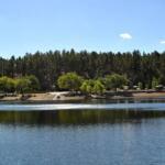
Lake Havasu is a distinct anomaly in the American Southwest—a massive, shimmering expanse of blue cutting through the stark, red-rock desert on the Arizona-California border. For the serious angler, this isn't just a recreational playground for jet skis; it is a complex fishery defined by its structure, from the deep canyons near Parker Dam to the tule-lined flats upriver. The vibe here shifts dramatically from the manicured, high-traffic channels near London Bridge to the rugged, silent coves accessible only by boat along the shoreline. It is a place where the desert heat meets cool Colorado River currents, creating a unique biological engine that supports world-class sportfishing.
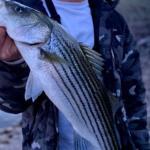
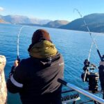
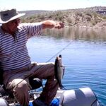
The primary draw for seasoned captains here is the diversity of the catch, anchored by a legendary bass fishery. Whether you are flipping jigs into heavy cover or running deep-diving crankbaits off the rocky points, the topography demands versatility. The water here is managed by the Bureau of Land Management (BLM) and fluctuates based on downstream water demands, meaning the "hot spot" you found last month might be high and dry—or too deep—today. Navigating Havasu requires an understanding of both the natural desert rhythms and the man-made pulse of the river system.
Beyond the fishing, the logistics of Havasu are unique. You are operating on a border water where state lines blur in the middle of the channel, and access points range from multi-lane concrete mega-ramps to primitive gravel washes. The heat is a constant factor; equipment that holds up elsewhere can fail under the relentless solar pounding here. Successful trips in this region are defined by preparation—knowing exactly where to launch to avoid the recreational flotillas and understanding how the desert winds funnel through the canyons.
Access & Getting There
Reaching Lake Havasu generally involves a drive through the heart of the Mohave Desert. The primary artery is AZ Highway 95. If you are coming from the north via I-40 near Needles, California, you will head south; from the south near Quartzsite, Arizona and I-10, you will head north. Traffic on Highway 95 can be deceptive; while it is a rural highway, it bottlenecks severely near Lake Havasu City during weekends and holidays. Pros know to time their arrival for early dawn or late evening to avoid the heat-shimmer delays behind RV convoys.
For those targeting the southern end of the lake, Take Off Point is a critical strategic access hub. Located approximately 16 miles south of Lake Havasu City via Alternate Highway 95, this facility offers free public boating access. It is situated near Parker Dam on the Arizona side and includes universally accessible fishing docks. This is often a superior launch choice for anglers wanting to bypass the heavy recreational traffic centered around the city's main marina. The ramp here puts you immediately into deep, structure-rich water without a long idle zone.
💡 Captain's Tip: The Dam Crossing Restriction
If you are navigating between the Arizona and California sides near the dam, be explicitly aware: Oversized vehicles and vehicles towing trailers are NOT permitted to cross Parker Dam. If you are towing a boat, you cannot use the dam as a bridge. You must route around, which can add significant time to your trip. Plan your launch side accordingly.
On the California side, access is more rugged. The Cable Car Day Use Area is located within the Parker Strip Recreation Area, about four miles south of the dam. While it provides river access, it has zero facilities—no restrooms, no water, no paved ramp. This is strictly for car-top vessels or bank fishing. If you are launching a full-sized bass boat on the California side, you are likely looking at Havasu Landing or driving further to find suitable concrete. The wind on Havasu is notorious; when the afternoon thermal winds kick up, the central basin can turn into a washing machine. Launching at Take Off Point or utilizing the London Bridge channel can offer some protection depending on wind direction, but always have a bailout plan if the main lake capsizes.
Parking logistics vary wildly. In town, the English Village Parking Lot and Public Parking on London Bridge Road are paved and close to amenities, but they fill rapidly with tourists. At Take Off Point, parking is generally more available for trailers, but security is lower due to the remote location. Always strip your deck of expensive electronics if leaving the rig unattended. For those with 4x4 capabilities looking to scout shoreline spots, the Standard Wash OHV Area offers a network of trails, but ensure your vehicle is street legal or properly decaled for Arizona off-highway use.
Lake Havasu Pre-Trip Checklist
Facilities & Amenities
The infrastructure around Lake Havasu caters heavily to the boating community, but expert anglers know where to find the specialized gear. Bass Tackle Master on London Bridge Road is the premier outlier for serious tackle. Unlike generic big-box stores, this shop is dialed into the local bite, stocking the specific colors and terminal tackle required for Havasu's clear water. They open at 6:00 AM most days, making them a viable stop for bait and ice before the sun breaches the horizon. For those launching further south near Parker, Colorado River Outfitters on South California Avenue is the local authority.
Fuel and heavy logistics are handled best at Lake Havasu Marina. Located centrally at 1100 McCulloch Blvd N, they have the capacity to handle larger vessels and offer the standard amenities you expect from a high-volume harbor. However, be advised that "marina pricing" applies. For those staying on the water, the Havasu Landing Marina Mini Market on the California side provides essential provisions, but stock can be limited compared to the city side. The Lake Havasu Yacht Club also maintains a presence here, signaling the availability of support for larger cruising vessels.
💡 Captain's Tip: Know What's Missing
Do not expect services at remote launch points. Cable Car Day Use Area has absolutely no facilities—no toilets, no water, no trash service. Take Off Point has restrooms and parking but no fuel or specialized tackle shop on site. If you launch south, bring everything you need for the day, including backup fluids and ample hydration.
Lodging for the "dawn patrol" angler requires strategic selection. Windsor Campgrounds (part of the State Park) is a favorite for those who want to wake up next to the water, offering immediate access. For a more rugged experience, the BLM manages 73 boat-in campsites known as the Lake Havasu Shoreline Sites. These are scattered along 20 miles of the Arizona shore. They offer picnic tables and shade structures but are first-come, first-served. Securing one of these sites allows you to stay on the fish without hauling out every evening, a massive tactical advantage during the prime spring spawn.
| Facility Name | Type | Key Features | Distance from Center |
|---|---|---|---|
| Take Off Point | Launch & Fishing | Free access, accessible docks, near Parker Dam | ~16 miles South |
| Lake Havasu Marina | Full Marina | Fuel, slips, supplies, central location | ~5 miles |
| Bass Tackle Master | Tackle Shop | Specialized gear, 6 AM opening, expert intel | ~5.8 miles |
| Shoreline Sites | Camping | 73 Boat-in sites, shade structures, BBQ grills | Various (20 mile stretch) |
| Cable Car Day Use | River Access | No facilities, CA side, car-top access only | ~13 miles |
Permits, Regulations & Fees
Navigating the legalities of Lake Havasu is critical because it is a shared border water. While the lake physically touches California, the primary management and licensing enforcement often default to Arizona regulations for the main body. A valid Arizona fishing license is required for all anglers 10 years of age or older fishing any public water in Arizona, including the shoreline. Blind residents and youth under 10 are exempt. It is vital to carry your license physically or digitally, as enforcement by Arizona Game and Fish is active, particularly near high-pressure areas like the Take Off Point docks.
The Bureau of Land Management (BLM) oversees the Lake Havasu Special Recreation Management Area. While general boating access at places like Take Off Point is free, using the Shoreline Sites for camping requires a fee. You can purchase passes digitally via Recreation.gov or at local kiosks. If you are venturing into the backcountry, such as the Cupcake Mountain Hiking Trail area or the Whipple Mountains Wilderness, be aware that these are protected zones. Motorized vehicles are strictly prohibited off designated routes to protect the fragile desert crust and tortoise habitat. Respect "Kapu" (forbidden/keep out) signs on private lands or native allotments, particularly on the California shore.
💡 Captain's Tip: Invasive Species Protocol
The Clean, Drain, Dry protocol is not optional here; it is a biological imperative. Quagga mussels are a major threat to the Colorado River system. Law enforcement frequently checks boats for plugs and standing water. Ensure your livewells are dry and your hull is clean before approaching any launch ramp to avoid hefty fines and denied access.
Events & Seasonal Information
The rhythm of Lake Havasu is dictated by two opposing forces: the recreational boating season and the biological fishing season. Summer brings extreme heat (often exceeding 110°F) and immense crowds of recreational boaters, wakeboarders, and the "spring break" crowd, particularly in the Bridgewater Channel. For the serious angler, the summer bite is a night game or a strictly "first light" endeavor. The boat traffic by 10:00 AM can make precision structure fishing nearly impossible in the main basin.
Winter and Spring are the prime windows for the dedicated sportsman. The cooler temperatures quiet the recreational traffic, leaving the lake open for bass tournaments and serious exploration. The Cable Car Day Use Area and southern river stretches are particularly popular in winter due to the milder weather compared to the high desert plateaus. This is also when the Lake Havasu Fisheries Improvement Program projects—like the habitat structures near Take Off Point—shine, holding fish that are moving up for the pre-spawn.
Be aware of the wind patterns. The prevailing winds can whip down the Colorado River valley with surprising ferocity. In the winter, northern winds can make the main lake unnavigable for smaller bass boats. Always check the forecast for "Lake Wind Advisories" before leaving the launch. If the whitecaps are rolling, stick to the protected coves or the river channel below the dam.
Contact Information & Resources
For official information regarding water levels, camping availability, and land access, the primary authority is the BLM Lake Havasu Field Office. They can be reached at 928-505-1200 or visited at their physical office on Kiowa Avenue. For specific fishing regulations and licensing, consult the Arizona Game and Fish Department. In emergencies, be aware that cell service can be spotty in the deep canyons and near the wilderness boundaries; a VHF radio is a recommended piece of safety gear for any boat venturing far from the main city channel.
For precise launch locations, real-time weather overlays, and detailed maps of the shoreline campsites, consult the interactive dashboard and nearby spot widgets below.

Leave a Reply