Nestled deep within the rugged Superstition Wilderness, Apache Lake is the crown jewel of the Salt River chain. Surrounded by towering canyon walls and studded with iconic Saguaro cacti, this fjord-like reservoir rewards anglers willing to navigate its remote access with some of the most spectacular multi-species action in the Southwest. As seasonal warming trends trigger heavy feeding windows, the fishery is currently experiencing a prime transitional bite. The following intelligence brief combines verified biological ground truth with professional on-the-water tactical experience to maximize your success.
1. GO/NO-GO STATUS
Verdict: GO - WITH LOGISTICAL CAUTION
The fishery itself is in stellar condition and wide open for business, but getting your boat to the water requires strategic planning. The notorious Fish Creek Hill section of the Apache Trail (State Route 88) from the western Apache Junction side is frequently impassable or entirely closed to towing a boat trailer due to steep, unpaved switchbacks and washout risks. You must approach the lake from the east via Highway 188 to SR 88 near Roosevelt Dam. This adds drive time but ensures your trailer axles remain intact.
From the editor
Tired of fishing with strangers you can’t trust?
Nautrek is the first social network for serious anglers — verified partners, real trips, cost splitting and intel sharing without burning your spots. Private beta now open.
Weather conditions are stabilizing into a classic desert warming pattern, with crisp, pleasant mornings rapidly giving way to hot afternoons. Water temperatures are hovering in the upper-sixties to mid-seventies, serving as the perfect catalyst for post-spawn feeding frenzies. Apache Lake is famous for its exceptional water clarity compared to neighboring reservoirs, offering six to ten feet of visibility. This high visibility dictates strict finesse presentations and stealthy boat positioning.
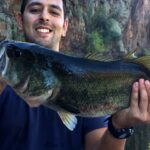
Recent biological data and on-the-water observations confirm that both Florida-strain Largemouth and the lake's robust Smallmouth Bass populations are metabolically shifting into high gear. With the spawn largely in the rearview mirror, these fish are migrating from shallow flats toward secondary shoreline points and rock transitions to intercept baitfish. Lower fishing pressure on Apache compared to other local lakes is allowing these bass to remain naturally positioned and aggressively feed around structure.
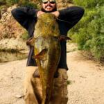
Sleeper Pick: Yellow Bass and Buffalofish
While the black bass get all the glory, the Yellow Bass in Apache Lake offer phenomenal, fast-paced action that most anglers drive right past. These fish school up tightly in deeper water and provide relentless action on light tackle once located. Furthermore, for the true species hunter, Apache Lake is home to a world-renowned population of Bigmouth and Smallmouth Buffalofish. Recent biological studies have verified that some of the Buffalofish swimming in these waters are over 100 years old, remnants of original stockings from the early 20th century. While difficult to target with traditional rod and reel, specialized pack bait techniques similar to European carp fishing can yield a true prehistoric river monster.
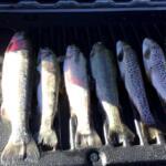
Baitfish Report: Threadfin Shad and Crayfish
The primary forage driving the current bite consists of Threadfin Shad and molting crayfish. Bass are keying in on shad schools during the low-light hours of early morning, then shifting their focus to the bottom to root out crayfish as the sun penetrates the water column.
3. TACTICAL STRATEGY
Apache Lake's bathymetry is uniquely fjord-like, quite different from the sprawling flood plains of nearby reservoirs. The lake features incredibly steep, rocky banks that plunge quickly into deep water. To capitalize on the current bite, you must fish with precision along these dramatic depth changes. Generic casting out into the middle of coves will not yield results in these clear, pressured waters.
Where: Focus your efforts on the secondary points leading out of spawning coves, specifically targeting the 6 to 18-foot depth range. The steep, 5-degree chunk rock banks near the Burnt Corral area and the submerged ledges near the Salt River inlet are holding high concentrations of actively feeding fish. As the sun climbs, shift your focus toward submerged brush and the edges of deeper drop-offs.
Lure Selection: For the early morning reaction bite, a 1/2 oz white and chartreuse spinnerbait or a topwater walking bait will draw vicious strikes. Once the sun hits the water, transition immediately to bottom-contact finesse baits. A 3/8 oz tungsten football jig paired with a craw trailer is deadly on the rocky points.
Color Palette: The exceptional water clarity demands natural hues. For jigs and plastics, rely heavily on Brown/Purple, Green Pumpkin, and Watermelon Copper. If you are throwing drop shots, a 6-inch straight tail worm in Morning Dawn or Natural Shad is non-negotiable.
Bait and Rigging: If utilizing live bait, threadfin shad fished on a slip-sinker rig near the channel swings will produce quality fish. For the Yellow Bass sleeper pick, vertically jig a 1/8 oz tungsten teardrop spoon or a small white grub on a 1/16 oz jighead in 20 to 30 feet of water where you mark bait balls on your electronics.
Timing: The primary feeding window is exceptionally tight. You need to be on your best spots from first light (around 5:30 AM) until 10:00 AM. After 10:00 AM, the bite becomes highly technical, requiring you to slow down your presentation and fish deeper structure.
Pro Tip: Because of the 6 to 10-foot water clarity, downsize your line. Utilize a 15-pound braided mainline connected to a long (12-15 foot) leader of 6 or 8-pound fluorocarbon. This setup provides the invisibility required to fool line-shy smallmouth while maintaining the sensitivity needed to detect subtle, deep-water bites.
Pro Tip: Pay close attention to the wind funneling through the canyon walls. The steep topography can create localized wind tunnels that whip up whitecaps in one cove while the adjacent bay remains glass-calm. Use these wind-blown points to your advantage, as the chop breaks up the light penetration and pushes baitfish against the rocks, triggering aggressive feeding from larger bass.
4. REGULATIONS SNAPSHOT
Before launching, ensure you are fully compliant with all local and state regulations. Enforcement is active, particularly near the marina and developed campgrounds.
Regulation Category
Details & Restrictions
Licensing & Passes
A valid Arizona State fishing license is required. Additionally, a Tonto Daily Pass and Watercraft Sticker (or Tonto Discovery Pass) are mandatory for boating and parking.
General Bag Limits
Standard AZGFD limits apply: 6 Bass (Largemouth/Smallmouth combination), 4 Channel Catfish, and unlimited Yellow Bass. Always verify current limits before your trip.
Boating Rules
Direction of travel on the lake is counter-clockwise. The upper end of the lake is closed to water skiing. Strictly observe all "No Wake" buoys near developed sites, coves, and the marina.
Special Methods
Bow and arrow fishing for catfish is legal on Apache Lake (subject to the 5 catfish daily bag limit). All incidentally caught protected native fish must be immediately released unharmed.
Pro Tip: Pack out what you pack in. The US Forest Service and local volunteer groups work tirelessly to maintain this pristine environment, including recent habitat restoration projects sinking thousands of Christmas trees to create fish cover. Respect the resource by leaving no trace.
5. REGIONAL ALTERNATIVE
If the drive down the Apache Trail seems too daunting, or if high winds make the narrow canyon waters of Apache Lake unfishable, Roosevelt Lake is your premier backup destination. Located just a short drive back up Highway 188, Roosevelt is the largest lake entirely within Arizona and offers massive amounts of accessible water.
At Roosevelt, you will find slightly more stained water, which makes the bass less line-shy. The current tactical approach there mirrors Apache's late-spring patterns: target submerged brush and transition zones in 10 to 20 feet of water using Texas-rigged creature baits and deep-diving crankbaits. Roosevelt also boasts exceptional Crappie fishing; locate submerged timber in the Tonto end of the lake and vertically fish live minnows or chartreuse tube jigs for a guaranteed fish fry.
Tight lines!
Editor's Choice: Must-Have Gear
FISHINGSIR Next-Gen Waterproof Chest Waders
★★★★★4.4 (7,370+ reviews)
2-Ply Tech: Upgraded nylon with 2.5x higher density than standard fabrics.
100% Waterproof: Lab-approved intrusion resistance with taped visible seams.
Ultra-Lightweight: Designed for all-day comfort while hunting or fishing.
As an Amazon Associate I earn from qualifying purchases. #ad
Loading forecast...
Live Fishing Conditions: Tides, Weather & Waves
Get real‑time tides, marine weather, swell and solunar activity for each spot so you know exactly when conditions line up for your best chance at a bite.
🎣
Apache Lake, AZ
Loading coordinates...
🌤️
WEATHER CONDITIONS
--°F
--°C
Loading...
🌡️
Feels Like--°F--°C
💧
Humidity--%
💨
Wind-- mph-- km/h
🧭
Direction--
📊
Pressure-- inHg-- hPa
☀️
UV Index--
🌊
MARINE CONDITIONS
🌊Wave Height
-- ft
-- m
Loading...
🧭Wave Direction
--°
Loading...
⏱️Wave Period
-- s
Loading...
📈Tide Status
-- ft
-- m
Loading...
🌙
LUNAR & SOLUNAR
🌕
Loading...
Illumination: --%
Major Period--:-- - --:----:-- - --:--
Minor Period--:-- - --:----:-- - --:--
🌅Sunrise--:--
🌇Sunset--:--
📅
24-HOUR FORECAST
Loading fishing conditions...
Fishing Spots Map
🎣
Book a Fishing Charter near Apache Lake, AZ Fishing Report Today 🎣
Local guides & charters. Verified captains, instant booking, best price guaranteed.
There was an error loading the map. Please try refreshing the page.
Info
Local Access & Facilities
Nestled deep within the Superstition Wilderness, Apache Lake represents a rugged, high-reward fishery for anglers willing to navigate the logistical challenges of the Salt River chain. Unlike its bustling neighbor Roosevelt Lake, this reservoir offers a more secluded experience, characterized by steep canyon walls, clear blue water, and a shoreline studded with iconic Saguaro cacti. The lake stretches 17 miles, making it the longest in the chain below Roosevelt Dam, providing ample structure for serious game fish hunters.
The primary draw here is the diverse bass fishery, featuring substantial populations of Largemouth and Smallmouth Bass that thrive in the deep, rocky topography. Beyond bass, the lake holds impressive numbers of Crappie, Sunfish, and massive Flathead and Channel Catfish that patrol the darker depths. The atmosphere is distinctly Sonoran Desert—stark, beautiful, and unforgiving regarding heat and exposure—demanding self-reliance from any captain planning a multi-day excursion.
💡 Captain's Tip: Seasonal Water Clarity
Apache Lake is known for its clear water conditions compared to other Salt River reservoirs. When targeting Smallmouth Bass along the rocky cliffs, downsize your line diameter and opt for natural fluorocarbon leaders to avoid spooking fish in the high-visibility water.
Access & Getting There
Reaching Apache Lake requires careful route planning, particularly for those towing varied vessel sizes. The most critical logistical detail for seasoned anglers is the current road status. The direct access to Burnt Corral from Tortilla Flat via AZ-88 East (The Apache Trail) is frequently closed due to washouts and maintenance. You must verify this before departure, as turning a trailer around on these narrow mountain roads is nearly impossible.
For reliable access, especially when trailering, the recommended route approaches from the Roosevelt Dam side. From the Mesa area, seasoned skippers head north on AZ-87 for approximately 59 miles, turning right onto AZ-188 South. After 31.6 miles, turn right onto AZ-88 West. Continue past the historic Roosevelt Dam for about 5 to 6 miles to reach the Burnt Corral Recreation Site. This route is paved but winding; ensure your trailer brakes are in top condition for the descent into the canyon.
The primary launch facility is at Burnt Corral Campground. The ramp here is paved and generally accessible, featuring a boat boarding dock that aids in solo launching. However, water levels in the Salt River chain fluctuate significantly based on agricultural demand and drought conditions. At lower water levels, the ramp can become steep and slick with algae. Parking at the ramp is available but limited during peak weekends; getting "dawn patrol" timing is essential not just for the bite, but for a slot for your trailer.
💡 Captain's Tip: The "Back Way" Warning
Do not trust standard GPS routing blindly. Access via the unpaved section of the Apache Trail (from Tortilla Flat) is often gated shut. Always route through Globe or via AZ-188 past Roosevelt Lake to avoid a mandatory U-turn with a boat trailer.
Apache Lake, AZ Pre-Trip Checklist
Facilities & Amenities
Infrastructure at Apache Lake is focused on camping and basic launch access rather than commercial marina services. The Burnt Corral Campground serves as the central hub for anglers. It offers 76 camp units, many of which accommodate boat trailers (up to 32 feet), though hookups are non-existent. The site provides potable water hydrants and vault toilets, but you should not expect luxury amenities. Shade is a premium commodity here; while some sites have shade ramadas, the surrounding Mesquite and Palo Verde trees offer only dappled relief from the midday sun.
For those requiring more extensive facilities, the Windy Hill Campground is located approximately 7.5 miles away on nearby Roosevelt Lake. Windy Hill is significantly larger, with 147 units, showers, and a fully accessible boat ramp. If Apache Lake's facilities are at capacity, Windy Hill serves as a strategic fallback location, allowing you to trailer over to Apache for day trips. Note that specialized gear shops are scarce in the immediate vicinity. The nearest data-listed bait supply is 188 Upholstery (which stocks bait) roughly 16.5 miles away in Tonto Basin. Serious anglers should arrive fully stocked with tackle, ice, and fuel.
Local Facility Overview
Facility Name
Type
Key Features
Distance from Spot
Burnt Corral Campground
Access & Camping
Paved Boat Ramp, Dock, 76 Campsites, Potable Water
0.4 miles
Windy Hill Campground
Campground
Showers, Accessible Ramp, Fish Cleaning Station, 147 Sites
7.5 miles
Frazier Horse Campground
Equestrian Camp
Corrals, Vault Toilets (Near Roosevelt Dam)
5.4 miles
Coyote Boat Launch
Boat Launch
Trailer Parking Available
7.3 miles
💡 Captain's Tip: Fuel Management
There are no fuel docks directly accessible at the Burnt Corral launch. Top off your tanks in Globe or Tonto Basin before descending AZ-88. Running out of gas in the canyon usually means a long wait for a tow.
Permits, Regulations & Fees
Fishing Apache Lake requires adherence to Arizona Game and Fish Department regulations. A valid Arizona fishing license is mandatory for all anglers 10 years of age and older. The lake is managed in conjunction with the Tonto National Forest, and a Tonto Pass is typically required for parking and day-use at recreation sites like Burnt Corral and Windy Hill. These passes must often be purchased in advance at authorized vendors, as on-site kiosks may not always be reliable or present.
Anglers should be aware of the cultural and historical significance of the Tonto Basin. The area is rich in history, including the nearby Tonto National Monument, which preserves cliff dwellings of the Salado culture dating back to 1300 CE. While fishing, respecting the shoreline is critical; removing artifacts or disturbing archaeological sites is a federal offense. Additionally, "Kapu" or restricted areas may exist near sensitive wildlife habitats or dam infrastructure—always observe posted signage near Roosevelt Dam.
Events & Seasonal Information
The rhythm of Apache Lake is dictated by the desert seasons. Summer temperatures frequently exceed 100°F, making early morning and night fishing the standard for serious locals. During these months, recreational boat traffic (water skiers and wakeboarders) picks up significantly by 10:00 AM. Pros know to be off the main channel and working deep structure or coves by mid-morning to avoid the wake.
Winter and spring offer solitude and excellent fishing for Smallmouth Bass as the water cools. The lake is less prone to the violent wind shifts that plague the larger Roosevelt Lake, but the canyon walls can funnel winds during storms, creating choppy conditions rapidly. While there are no major professional tournaments exclusive to Apache Lake listed recently, the Salt River chain is a hotbed for regional bass clubs. Anglers should check local boards for club tournaments that might crowd the single launch ramp at Burnt Corral on spring weekends.
Contact Information & Resources
For the most current information regarding lake levels, fire restrictions, and road closures, direct contact with the managing agencies is recommended before hitching up the boat.
Managing Agency: Tonto National Forest - Tonto Basin Ranger District
Phone: (602) 225-5395
Nearby Cultural Site: Tonto National Monument - (928) 467-2241
Emergency: Dial 911 (Note: Cell service is spotty in the canyon; reliable signal is often found near the dam or higher elevations).
For precise locations of the boat ramps, real-time weather overlays, and detailed topography of the lake floor, consult the live dashboard and interactive maps below.
Our spot reports combine data-driven forecasts with curated local information. The forecast is generated by our proprietary Fishing Score algorithm (0–100%), which analyzes real-time data from Open-Meteo API, validated against NOAA CO-OPS tide gauges and USGS water-monitoring stations. The model weights tide dynamics (35%), wave energy (25%), wind patterns (20%) and time of day (20%)—factors shown to influence fish feeding behavior through marine-biology research and decades of charter log data.
Access, facilities and services information for each fishing spot is sourced from official datasets such as Recreation.gov (RIDB), state park & wildlife agencies, and geospatial providers like Google Maps. These sections undergo scheduled re-validation every 3–6 months to ensure that boat ramps, park access, contact details and local services remain accurate.
Narrative sections (catches, seasonal behavior, local tips) are synthesized from these data sources and refined following the Fishing Reports Today editorial guidelines, combining bibliographic research from ichthyology and oceanography with expert angler experience. Our team reviews reports on a regular basis, while the forecast model itself updates every 6 hours for real-time accuracy.
⚠️ Important: Always verify current local regulations, access restrictions and weather conditions before fishing. These reports are intended as a planning aid, not a guarantee of catches or safety. When in doubt, contact local authorities or park managers listed on the page.
To provide the best experiences, we use technologies like cookies to store and/or access device information. Consenting to these technologies will allow us to process data such as browsing behavior or unique IDs on this site. Not consenting or withdrawing consent, may adversely affect certain features and functions.
Functional Always active
The technical storage or access is strictly necessary for the legitimate purpose of enabling the use of a specific service explicitly requested by the subscriber or user, or for the sole purpose of carrying out the transmission of a communication over an electronic communications network.
Preferences
The technical storage or access is necessary for the legitimate purpose of storing preferences that are not requested by the subscriber or user.
Statistics
The technical storage or access that is used exclusively for statistical purposes.The technical storage or access that is used exclusively for anonymous statistical purposes. Without a subpoena, voluntary compliance on the part of your Internet Service Provider, or additional records from a third party, information stored or retrieved for this purpose alone cannot usually be used to identify you.
Marketing & Affiliates
The technical storage or access is required to create user profiles to send advertising, or to track the user on a website or across several websites for similar marketing purposes, including affiliate tracking for products recommended in our reports.


Leave a Reply