As a Senior Fishing Editor and local Pro Guide, I spend countless hours analyzing the shifting patterns of Raritan Bay. The spring transition is one of the most dynamic and explosive times to fish this nutrient-rich estuary. As the sun bakes the shallow mudflats and the migratory biomass pushes into the system, the bay transforms into a world-class fishery. Below is your comprehensive, tactical breakdown to maximize your time on the water.
1. GO/NO-GO STATUS
Verdict: CAUTION - TARGETED GO
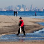
The bay is currently wide open and fishing exceptionally well, but safety must remain your top priority. We are in a transitional weather pattern where stiff, unpredictable northwesterly winds can rapidly turn the open bay into a washing machine.
From the editor
Tired of fishing with strangers you can’t trust?
Nautrek is the first social network for serious anglers — verified partners, real trips, cost splitting and intel sharing without burning your spots. Private beta now open.
Water temperatures are hovering in the critical mid-to-high 40s and low 50s depending on the tide and time of day. While the bite is hot, the water is still dangerously cold. A personal flotation device (PFD) is absolutely mandatory. For larger center consoles, the open bay is a definitive GO. For kayak anglers and small skiffs, exercise extreme CAUTION and stick to the protected shorelines or tidal rivers when the wind exceeds 15 knots.
2. SPECIES INTEL
Primary Target: Striped Bass
The undisputed king of the spring run is the Striped Bass. We are currently seeing a massive push of migratory fish joining the resident holdovers. These bass are utilizing the slightly warmer waters of the bay to feed heavily on incoming bait schools before continuing their migration. The fish are aggressive, heavily schooled, and holding over dark bottom structure that radiates heat.
Sleeper Pick: White Perch
While the fleet chases stripers, the White Perch bite in the brackish tributaries is quietly going off. These fish are staging for their spawning runs and are tightly schooled in the deeper holes of the tidal rivers. If you find one, you will likely find dozens. They offer fantastic light-tackle action and are a perfect target when the main bay is too rough to fish.
Baitfish Report: Match the Hatch
The true catalyst for the spring run is the arrival of adult Atlantic Menhaden (bunker). Massive schools of these deep-bodied baitfish are pushing into the nutrient-rich waters of the bay. You will also find a mix of grass shrimp, marine worms, and smaller forage like spearing and killifish in the shallow estuarine zones.
Pro Tip: When targeting trophy stripers, ditch the slender profile lures. You must upsize your presentation to a wide-bodied profile to properly mimic an adult bunker in distress.
3. TACTICAL STRATEGY
Where to Target
Do not waste time blindly casting in the open channel. Focus your efforts on the dark mudflats on the western side of the bay. The Triangle (located between South Amboy and Staten Island near the Great Beds Lighthouse) is a premier staging area. From there, the fish are pushing onto the Keyport Flats and Old Orchard Shoal.
Look for depths of 10 to 20 feet where the gradual contour meets a sharp drop-off. The dark, muddy bottom absorbs the afternoon sun, raising the water temperature a few crucial degrees and triggering intense feeding windows.
Lure and Bait Selection
Artificial Lures: Jigging is highly effective right now. Deploy large flutter spoons, specifically the Ben Parker Magnum Spoon, which perfectly mimics a dying adult bunker. Alternatively, heavy-weighted paddletail shads (6 to 9 inches) are producing violent strikes.
Colors: Spring runoff often leaves the bay stained and murky. Stick to high-visibility colors: chartreuse, pearl white, or a classic bunker pattern with a chartreuse tail.
Bait Fishing: If you prefer soaking bait, fresh surf clams are the ticket. Anchor upcurrent of a drop-off or mussel bed.
Pro Tip: When fishing clams, take two dozen clams, place them in a 5-gallon bucket with a little seawater, and smash them to create a "clam soup". Slowly dump this over the side of the boat. It mimics the scent of commercial clammers raking the bottom and will ring the dinner bell for nearby stripers.
Timing the Bite
Incoming tides are generally producing the most consistent action, as they push fresh bait over the flats. However, the most critical factor right now is the sun. A series of high-sun, windless days will activate the mudflats. Plan your trips for the late afternoon when the water has had several hours to bake in the sun, raising the temperature to its daily peak.
4. REGULATIONS SNAPSHOT
Note: Always verify local regulations as they are subject to in-season changes by the ASMFC and state agencies.
Species
Size Limit
Bag Limit
Special Gear Rules
Striped Bass (NJ/NY)
28" to less than 31" Slot
1 fish per angler
Inline, non-offset circle hooks MANDATORY when using natural bait. No gaffing allowed.
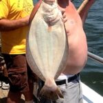
Summer Flounder (Fluke)
Typically 17" - 18" (Zone Dependent)
2 to 3 fish (Zone Dependent)
Standard bottom rigs; season typically opens in early May.
White Perch
No minimum size
No bag limit (in most tidal waters)
Standard light tackle permitted.
5. REGIONAL ALTERNATIVE
If a hard northwest blow renders the open waters of Raritan Bay unfishable, pivot your strategy inland. The brackish reaches of the Raritan River near New Brunswick, or the sheltered waters of the Navesink River to the south, offer excellent fallback options.
The heavy tree lines and bulkheads block the coastal winds, making these areas comfortable and highly productive. Scale down your tackle and target White Perch and holdover schoolie Striped Bass. Use a traditional high-low rig tipped with live bloodworms, or throw a 1/8oz tungsten tear-drop jig tipped with a Berkley Gulp! bloodworm snippet. Work the structure tightly around bridge pilings and deep river bends.
Tight lines!
Editor's Choice: Must-Have Gear
FISHINGSIR Next-Gen Waterproof Chest Waders
★★★★★4.4 (7,370+ reviews)
2-Ply Tech: Upgraded nylon with 2.5x higher density than standard fabrics.
100% Waterproof: Lab-approved intrusion resistance with taped visible seams.
Ultra-Lightweight: Designed for all-day comfort while hunting or fishing.
As an Amazon Associate I earn from qualifying purchases. #ad
Loading forecast...
Live Fishing Conditions: Tides, Weather & Waves
Get real‑time tides, marine weather, swell and solunar activity for each spot so you know exactly when conditions line up for your best chance at a bite.
🎣
Raritan Bay
Loading coordinates...
🌤️
WEATHER CONDITIONS
--°F
--°C
Loading...
🌡️
Feels Like--°F--°C
💧
Humidity--%
💨
Wind-- mph-- km/h
🧭
Direction--
📊
Pressure-- inHg-- hPa
☀️
UV Index--
🌊
MARINE CONDITIONS
🌊Wave Height
-- ft
-- m
Loading...
🧭Wave Direction
--°
Loading...
⏱️Wave Period
-- s
Loading...
📈Tide Status
-- ft
-- m
Loading...
🌙
LUNAR & SOLUNAR
🌕
Loading...
Illumination: --%
Major Period--:-- - --:----:-- - --:--
Minor Period--:-- - --:----:-- - --:--
🌅Sunrise--:--
🌇Sunset--:--
📅
24-HOUR FORECAST
Loading fishing conditions...
Fishing Spots Map
🎣
Book a Fishing Charter near Raritan Bay Fishing Report Today 🎣
Local guides & charters. Verified captains, instant booking, best price guaranteed.
There was an error loading the map. Please try refreshing the page.
Info
Local Access & Facilities
Raritan Bay stands as a monumental intersection where the industrial might of the New York metropolitan area meets the raw, Atlantic-fed saltwater ecosystem. For the seasoned angler, this is not merely a bay; it is a complex tactical arena where deep shipping channels cut through expansive flats, creating a nutrient-rich funnel for migratory game fish. The backdrop here is unmatched, shifting from the distant Manhattan skyline to the rugged, dune-lined coast of Sandy Hook, offering a visual theater as dynamic as the fishery itself.The area serves as the strategic gateway between the open ocean and the harbor, creating strong tidal currents that scour the bottom and aggregate baitfish. While the casual weekend warrior might be distracted by the boat traffic, the expert knows that the structure along the edges of the channels and the rips off the hook hold massive potential. Whether you are targeting the flats or working the deeper cuts, success here requires an understanding of how urban infrastructure and natural topography coexist.
Access & Getting There
Accessing the prime waters of Raritan Bay requires navigating the dense infrastructure of Northern New Jersey. For those trailering boats from the south or west, the primary artery is the Garden State Parkway to Exit 117, feeding into Route 36 East. Seasoned skippers know that summer traffic on Route 36 can be brutal, particularly on weekends; a "dawn patrol" arrival is not just a fishing strategy, it is a logistical necessity to avoid the bumper-to-bumper crawl through Keyport and Middletown.
💡 Captain's Tip: Launch Logistics
Trailer parking at popular ramps fills rapidly. If you are targeting the Sandy Hook area, arrive well before sunrise. When winds oppose the tide, the bay can develop a steep, tight chop quickly—small skiffs should stick to the leeward shoreline during strong trade winds.
For boaters, the Great Kills Park Boat Ramp on the Staten Island side offers a reliable launch point into the bay, though it demands patience during peak season. On the Jersey side, access is often dictated by the tides. Non-motorized vessels, such as kayaks and canoes, have a dedicated launch at Horseshoe Cove within the Gateway National Recreation Area. This is a prime launch for stealth fishing the shallows, but be explicitly warned: landing a motorized boat on the beaches here is strictly prohibited and enforced.
Raritan Bay Pre-Trip Checklist
Facilities & Amenities
The local infrastructure is robust but specific. Unlike pristine wilderness fisheries, you are operating in a developed zone where specialized shops cater to serious saltwater pursuits. The area is serviced by several high-caliber bait and tackle shops that understand the "early out" mentality. Up Front Bait and Tackle in Keyport is a standout resource, opening its doors at 05:00 AM—critical for grabbing fresh bunker or clam before the morning bite ignites.
💡 Captain's Tip: Gear Hauling
If you plan to stay overnight at Camp Gateway, be aware there is zero vehicle access to the campsites. You must hike your gear 0.25 miles from the parking lot. Bring a heavy-duty wagon with sand tires; carrying coolers and tackle boxes by hand is a recipe for exhaustion before you even wet a line.
For anglers looking to connect with local knowledge or book a heavy-hitter trip, the local charter fleet is top-tier. Operations like Chasin' Tail Sportfishing in Port Monmouth and Kill Shot Charters in Atlantic Highlands are staples of the local community. These captains specialize in navigating the bay's shifting shoals and busy lanes. Note that while fuel and ice are generally available at commercial marinas, the National Park facilities at Sandy Hook are more primitive; do not expect a fuel dock at the Horseshoe Cove launch.
Facility Name
Type
Key Details
Distance
Up Front Bait and Tackle
Bait Shop
Opens 5:00 AM daily; Keyport location
6.5 miles
Camp Gateway - Sandy Hook
Camping
Tent only; Hike-in (0.25 mi); No showers
6.9 miles
Great Kills Park Ramp
Boat Launch
Trailer parking available; Busy weekends
3.5 miles
Chasin' Tail Sportfishing
Charter
Port Monmouth; 24-hour operations
3.7 miles
Accommodations for the hardcore angler are unique here. Camp Gateway offers a rare opportunity to sleep within earshot of the surf, but it is not for the "glamper." These are tent-only, hike-in sites with no electrical hookups and no showers—only flush toilets and running water are available. It is strictly a basecamp for those prioritizing proximity to the water over comfort.
Permits, Regulations & Fees
Navigating the regulatory environment in Raritan Bay is as critical as reading the depth finder. The area falls under the jurisdiction of multiple agencies, including the National Park Service (Gateway National Recreation Area) and state environmental departments. A valid saltwater fishing registry is required for anglers in both New York and New Jersey waters.
💡 Captain's Tip: Surfcasting Rules
Surf fishing is permitted on most beaches, but there is a hard rule: no fishing in guarded swimming areas when lifeguards are on duty (typically 10:00 AM to 6:00 PM). Plan your surf casting for dawn and dusk, or move to ungarded stretches like the "M" lot or Fishing Beach.
Conservation is heavily enforced here, particularly regarding bird nesting. During the spring and summer months, specific sections of the shoreline, often including prime spots near "M" lot, may be closed to protect endangered shorebirds. These closures are non-negotiable and clearly marked. Furthermore, respect the local "Kapu" regarding private property and military history; the Sandy Hook Proving Ground is a National Historic Landmark, and metal detecting or digging for artifacts is illegal.
Events & Seasonal Information
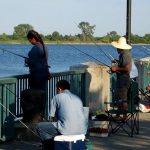
The fishing calendar in Raritan Bay is driven by the migration of striped bass and bluefish, followed by the summer fluke run. The peak recreational season runs from Memorial Day through Labor Day, coinciding with the heaviest boat traffic. During this window, the bay can feel like a washing machine by midday due to the convergence of wakes from ferries, tankers, and pleasure craft.Competitive anglers should keep an eye on the summer tournament circuits that frequent these waters. However, for the solitude-seeking pro, the "shoulder seasons" (late spring and early fall) offer the best combination of active fish and quieter waters. Be aware that amenities like the Camp Gateway are seasonal; the campground is staffed from late May to mid-July, but becomes unstaffed in the off-season, requiring self-reliance.
Contact Information & Resources
For the most current information on ramp conditions, closures, and camping availability, direct contact with the managing agencies is recommended.Gateway National Recreation Area (Sandy Hook Unit): (732) 872-5918Camp Gateway Staffed Line (Seasonal): (347) 630-1124* Emergency: 911 or VHF Channel 16Safety in Raritan Bay means respecting the shipping lanes. Large vessels have limited maneuverability, and small fishing boats must yield. Always maintain a radio watch and have your safety gear accessible.For precise locations, real-time wind conditions, and detailed bathymetry of the channels mentioned above, consult the live dashboard and interactive maps below.
Our spot reports combine data-driven forecasts with curated local information. The forecast is generated by our proprietary Fishing Score algorithm (0–100%), which analyzes real-time data from Open-Meteo API, validated against NOAA CO-OPS tide gauges and USGS water-monitoring stations. The model weights tide dynamics (35%), wave energy (25%), wind patterns (20%) and time of day (20%)—factors shown to influence fish feeding behavior through marine-biology research and decades of charter log data.
Access, facilities and services information for each fishing spot is sourced from official datasets such as Recreation.gov (RIDB), state park & wildlife agencies, and geospatial providers like Google Maps. These sections undergo scheduled re-validation every 3–6 months to ensure that boat ramps, park access, contact details and local services remain accurate.
Narrative sections (catches, seasonal behavior, local tips) are synthesized from these data sources and refined following the Fishing Reports Today editorial guidelines, combining bibliographic research from ichthyology and oceanography with expert angler experience. Our team reviews reports on a regular basis, while the forecast model itself updates every 6 hours for real-time accuracy.
⚠️ Important: Always verify current local regulations, access restrictions and weather conditions before fishing. These reports are intended as a planning aid, not a guarantee of catches or safety. When in doubt, contact local authorities or park managers listed on the page.
To provide the best experiences, we use technologies like cookies to store and/or access device information. Consenting to these technologies will allow us to process data such as browsing behavior or unique IDs on this site. Not consenting or withdrawing consent, may adversely affect certain features and functions.
Functional Always active
The technical storage or access is strictly necessary for the legitimate purpose of enabling the use of a specific service explicitly requested by the subscriber or user, or for the sole purpose of carrying out the transmission of a communication over an electronic communications network.
Preferences
The technical storage or access is necessary for the legitimate purpose of storing preferences that are not requested by the subscriber or user.
Statistics
The technical storage or access that is used exclusively for statistical purposes.The technical storage or access that is used exclusively for anonymous statistical purposes. Without a subpoena, voluntary compliance on the part of your Internet Service Provider, or additional records from a third party, information stored or retrieved for this purpose alone cannot usually be used to identify you.
Marketing & Affiliates
The technical storage or access is required to create user profiles to send advertising, or to track the user on a website or across several websites for similar marketing purposes, including affiliate tracking for products recommended in our reports.


Leave a Reply