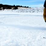
Current conditions require extreme vigilance from all anglers. The Bureau of Reclamation is actively conducting a high-water flow experiment aimed at disadvantaging invasive smallmouth bass, pushing dam releases to a roaring 4,600 CFS before initiating a scheduled ramp-down. Furthermore, the dam's selective withdrawal structure has been adjusted to release exceptionally cold water from the depths of Flaming Gorge Reservoir. While the summer weather has settled into the canyon—bringing beautiful air temperatures ranging from the upper 40s in the early morning to the low 80s by mid-afternoon—do not let the warm air deceive you. The water is dangerously swift, pushy, and frigid. Wading in Section A is currently hazardous and highly discouraged until flows stabilize. This is strictly a drift boat game right now. If you are floating, ensure all safety gear is secured, wear your personal flotation device at all times, and make sure rowers are experienced with heavy, technical water.
SPECIES INTEL
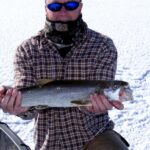
Primary Target: Brown Trout and Rainbow Trout. The Green River boasts an incredible density of trout, with estimates hovering around 10,000 fish per mile in the upper stretches. Brown trout make up the vast majority of the biomass in Section A, averaging around 15 to 16 inches, with a very healthy percentage breaking the 17-inch mark. They are opportunistic feeders but become highly structure-oriented when the river rises. Rainbow trout, while slightly less numerous, fight with incredible aerial acrobatics and are currently seeking the same current breaks as the browns.
🎣Nautrek
Private Beta
J
M
R
100+ anglers on the waitlist
The fishing network where your reputation matters.
Find trusted captains, join real trips with cost splitting, and build your Angler Rank. Your spots stay private — you decide who sees your intel.
Sleeper Pick: Mountain Whitefish. Often unfairly maligned by purists, this native species boasts a phenomenal population in the tailwater. They stack up in deep, slow seams and will eagerly take the same heavy nymph rigs used for trout, providing constant rod-bending action when the trout get fussy during flow fluctuations.
Baitfish & Forage Report: The high flows have temporarily suppressed the classic dry fly surface feeding, but the sub-surface buffet is wide open. The heavy current has dislodged massive amounts of aquatic worms, scuds, and sowbugs from the riverbed. On the insect front, Pale Morning Duns (PMDs), Yellow Sallies, and Caddis are all present in the system. There is also a phenomenal cicada hatch happening along the banks, which will become the main event as soon as the water levels recede and the surface calms.
Pro Tip:When dam releases spike dramatically, trout are forced out of the fast main current to conserve energy. Look for them stacked like cordwood in the soft inside bends, deep back-eddies, and flooded bankside vegetation.
TACTICAL STRATEGY
Where to Target
Focus your efforts on Section A, from the Flaming Gorge Dam down to Little Hole. Because of the surging CFS, completely ignore the fast middle of the river. Target the soft seams near the edges, the slow water behind large boulders, and deep foam-covered eddies near famous landmarks like the Lunch Counter and Secret Riffle. Fish are hugging the bottom and the banks to escape the heavy current.
Drift Boat Tactics
Since wading is largely off the table during this flow event, drift boat anglers have a distinct advantage. Oarsmen need to work hard to slow the boat's downstream progression, giving anglers enough time to drag heavy nymph rigs through the prime holding water. Focus on the inside bends where the current slows, and do not hesitate to drop your flies right against the canyon walls. The upper river features numerous steep sandstone drop-offs where fish will suspend just out of the main current, waiting for dislodged food to wash directly into their feeding lanes.
Pro Tip:When throwing streamers from a moving boat in heavy flows, cast downstream at a 45-degree angle and retrieve with short, aggressive strips. This keeps your fly swimming naturally with the current rather than being dragged unnaturally upstream.
Lure and Fly Selection
With surface action hindered by the rushing cold water, a heavy nymph rig is your absolute best weapon. Top producing patterns include:
Tungsten Rainbow Warrior: Size 14 (Extra heavy to pierce the current)
San Juan Worm: Size 12 in bright pink or red
Grey Sowbug: Size 14 and 16
Coffey's CH Sparkle Minnow Sculpin: Size 6 in white or olive for those looking to strip streamers
Bait and Rigging
Crucial Note: The use of any live or cut bait is strictly illegal on this stretch of the river. This is an artificial flies and lures only fishery. To get your nymphs down quickly in the heavy flow, use a 9-foot fluorocarbon leader with extra split shot placed above your first fly. A large, highly visible strike indicator is mandatory to detect subtle takes in the turbulent water.
Timing the Bite
The best bite windows are occurring later in the afternoon and into the evening. As the sun warms the canyon walls and ground temperatures rise into the mid-60s, terrestrial activity increases. Overcast afternoons are prime time for PMD and Blue Winged Olive emergences in the slower glides.
Pro Tip:If you see Mormon crickets or cicadas blown onto the water near the banks, immediately switch to a large foam terrestrial pattern. Even in high water, a massive meal floating overhead can trigger explosive surface strikes from trophy browns.
REGULATIONS SNAPSHOT
Before hitting the water, ensure you are compliant with these strict tailwater rules designed to protect the trophy fishery:
Regulation Category
Rule Details
Gear Restrictions
Artificial flies and lures ONLY. No bait allowed. No artificial lure may have more than three hooks.
Trout Limit
3 trout daily limit.
Slot Limit
2 trout under 15 inches, 1 over 22 inches. All trout between 15 and 22 inches MUST be immediately released.
Invasive Species
No limit on Smallmouth Bass, Burbot, Northern Pike, or Walleye. These species must be killed immediately and cannot be released back into the river.
Boating
No motorized boats allowed from the dam to the Colorado state line.
REGIONAL ALTERNATIVE
If the high-water experiment on the Green is too intimidating or you simply prefer to wade fish safely, pack up and head southwest to the Middle Provo River near Heber City. This world-class blue-ribbon tailwater offers much more manageable wading conditions during the summer months. Access the river via the River Road or Legacy Bridge parking areas.
Target the abundant brown trout by dead-drifting a bounce rig loaded with small midge larva and sowbugs (sizes 18-20) through the deep runs, or look for heads sipping PMD emergers in the slow tailouts during the late morning hatch. The Middle Provo is a classic limestone-style tailwater that requires a more stealthy approach. Use long 5x or 6x fluorocarbon tippets and tiny indicators. While the fish average slightly smaller than the Green River bruisers, the sheer numbers of brown trout in the Provo guarantee a rewarding day for anglers willing to refine their presentation, providing fantastic technical fishing without the whitewater hazards.
Tight lines!
Editor's Choice: Must-Have Gear
FISHINGSIR Next-Gen Waterproof Chest Waders
★★★★★4.4 (7,370+ reviews)
2-Ply Tech: Upgraded nylon with 2.5x higher density than standard fabrics.
100% Waterproof: Lab-approved intrusion resistance with taped visible seams.
Ultra-Lightweight: Designed for all-day comfort while hunting or fishing.
As an Amazon Associate I earn from qualifying purchases. #ad
Loading forecast...
Live Fishing Conditions: Tides, Weather & Waves
Get real‑time tides, marine weather, swell and solunar activity for each spot so you know exactly when conditions line up for your best chance at a bite.
🎣
Green River
Loading coordinates...
🌤️
WEATHER CONDITIONS
--°F
--°C
Loading...
🌡️
Feels Like--°F--°C
💧
Humidity--%
💨
Wind-- mph-- km/h
🧭
Direction--
📊
Pressure-- inHg-- hPa
☀️
UV Index--
🌊
MARINE CONDITIONS
🌊Wave Height
-- ft
-- m
Loading...
🧭Wave Direction
--°
Loading...
⏱️Wave Period
-- s
Loading...
📈Tide Status
-- ft
-- m
Loading...
🌙
LUNAR & SOLUNAR
🌕
Loading...
Illumination: --%
Major Period--:-- - --:----:-- - --:--
Minor Period--:-- - --:----:-- - --:--
🌅Sunrise--:--
🌇Sunset--:--
📅
24-HOUR FORECAST
Loading fishing conditions...
Fishing Spots Map
🎣
Book a Fishing Charter near Green River Fishing Report Today 🎣
Local guides & charters. Verified captains, instant booking, best price guaranteed.
There was an error loading the map. Please try refreshing the page.
Info
Local Access & Facilities
The High Desert Fishery: Green River, Wyoming
The Green River, cutting through the stark, high-desert landscape of Wyoming, offers a technical and visually arresting experience for the serious angler. This is not a manicured fishery; it is a rugged ribbon of life carving through red rock, sagebrush, and ancient geological formations. For the expert angler, the appeal lies in the isolation and the challenge presented by the environment itself. The water here demands respect, flowing through a landscape that can be unforgiving to the unprepared, yet incredibly rewarding for those who understand its rhythms.
The vibe here is distinctly Western—wide-open spaces where the silence is only broken by the wind and the rush of water. Unlike coastal harbors or urban reservoirs, the Green River area feels wild and exposed. The backdrop is dominated by features like Pilot Butte and the sprawling White Mountain, creating a dramatic theater for your time on the water. While the solitude is a primary draw, it requires a captain who is self-sufficient and comfortable navigating gravel roads and shifting weather patterns.
Anglers coming here are typically targeting cold-water game fish that thrive in these high-altitude flows. The ecosystem supports a robust food web, but success often hinges on understanding the specific flows and the seasonal insect hatches that drive feeding behavior. This is a location where reading the water is just as important as the gear in your box. The proximity to the Flaming Gorge system suggests a potential for trophy-sized catches, attracting seasoned pros who are willing to brave the elements for a shot at a personal best.
Access & Getting There
Reaching the prime waters of the Green River requires navigating a mix of interstate efficiency and backcountry grit. The primary artery into the region is I-80, a major trucking corridor that is notorious for high winds and winter closures. Most anglers will approach via Rock Springs or the town of Green River itself. From Rock Springs, the route often involves Highway 191 and a network of county roads. Be aware that traffic on I-80 can be heavy with commercial haulers; allow extra time for deceleration and merging, especially when towing a drift boat or skiff.
For those looking to launch, the area offers several access points, though they demand careful navigation. The data indicates multiple boat ramps situated within a 2 to 4-mile radius of the main river corridor. However, "ramp" in this region can vary from improved concrete to stabilized gravel. High desert winds can turn a simple launch into a hazardous operation. It is critical to scout the launch site before backing down, particularly if you are running a fiberglass hull. The water levels fluctuate significantly based on dam releases and seasonal melt, which can leave ramps high and dry or submerged in mud.
💡 Captain's Tip: Trailer Management
Many access roads, including parts of the Pilot Butte Wild Horse Scenic Tour, are gravel. Protect your hull and trailer wiring from flying stones. If you are towing a fiberglass boat, a rock guard is essential to prevent gel coat chips during the approach.
Weather is the single biggest logistical factor in this region. The wind generally howls from the west/southwest, sweeping across the open sagebrush with nothing to slow it down. When Trade winds or frontal systems push wind speeds above 15 knots, the exposed sections of the river and nearby reservoirs can become unmanageable. The Pilot Butte Wild Horse Scenic Tour route, which serves as a scenic access corridor, is largely gravel. During rain events, the clay-heavy soil can turn into "gumbo" mud, making travel difficult even for 4x4 vehicles. Always check the forecast for precipitation before committing to the backroads.
Parking strategies here differ from the typical marina scene. You won't find multi-story garages or valet service. Instead, you are looking at gravel lots and roadside pull-outs. Security is generally good due to the remoteness, but leaving valuables in plain sight is never navigating wise. For those needing to rig up or rest before a dawn patrol, the Truck Parking at Little America (Exit 68) offers a massive, 24-hour paved area about 20 miles out, ideal for checking bearings and securing tie-downs away from the dust.
Green River Pre-Trip Checklist
Facilities & Amenities
The infrastructure around Green River is functional and geared toward the outdoor realist rather than the luxury tourist. Do not expect a density of specialized tackle shops right at the water's edge. The logistics hub for this fishery is the Green River Chamber of Commerce Visitor Center located on Flaming Gorge Way. This is not just a place for brochures; it is a critical operational stop. This facility handles the sale of firewood, timber permits, and most importantly, maps and recreation passes. Expert captains know that securing these permits before hitting the gravel saves valuable fishing time.
Regarding gear and provisions, "negative knowledge" is vital here: there are no dedicated bait and tackle shops listed directly on the river banks in the immediate data set. You must bring your primary arsenal with you. Specialized fly patterns, tippets, and heavy trolling gear should be purchased in larger hubs like Rock Springs or ordered in advance. The Home Depot in Rock Springs serves as a last-resort hardware stop for trailer repairs or emergency rigging supplies, but it is over 10 miles away from the water.
💡 Captain's Tip: Fuel Logistics
There are no fuel docks on the river sections. Top off your vessel and tow vehicle in the town of Green River or at the Little America travel center on I-80. Running out of gas in the high desert is a dangerous inconvenience.
Accommodation options cater to two distinct styles of angler: the "comfort seeker" and the "hard-core boondocker." For those who want a hot shower after a dusty day on the water, the Hampton Inn & Suites Green River is strategically located less than a mile from the river corridor, making it an excellent base camp for early starts. Conversely, for the self-sufficient angler, the White Mountain Road Boondock area offers a raw, 5-star rated experience just under 3 miles away. This is dispersed camping at its finest—perfect for keeping an eye on the boat and waking up directly in the elements.
Local Lodging & Logistics Table
Facility Name
Type
Distance from Water
Captain's Notes
Hampton Inn & Suites
Hotel
~0.9 Miles
Closest hotel to the main launch zones. Ideal for dawn patrol.
White Mountain Road
Boondocking
~2.7 Miles
Open 24/7. High-rated dispersed camping. Zero amenities; bring water/power.
Sweetwater Events Complex
Campground
~13.7 Miles
Organized camping with likely hookups. Good for larger RV rigs.
Truck Parking - Little America
Parking/Staging
~20.2 Miles
Open 24/7. Massive lot. Excellent for final rig checks or waiting out storms.
Permits, Regulations & Fees
Navigating the bureaucracy is as important as navigating the river. Fishing regulations in this area are managed by the State Fishing Agency. It is imperative to carry a current state fishing license, as game wardens patrol these accessible areas regularly. The Green River Chamber of Commerce is the authorized vendor for Flaming Gorge Recreation Passes. If your expedition takes you downstream into the reservoir system or specific recreation areas, this pass is often mandatory in addition to your state license.
The area surrounding the river is a patchwork of public lands, including areas managed by the Bureau of Land Management (BLM) and the Ashley National Forest. A unique regulatory consideration here is the Pilot Butte Wild Horse Scenic Tour. This 24-mile self-guided route overlaps with access roads. While not a fishing regulation per se, federal laws strictly protect the wild horses found here. It is illegal to harass, chase, or feed them. Anglers towing boats through these zones must yield to livestock and wildlife. Driving speeds should be kept low to avoid collisions with free-roaming elk, deer, and horses, particularly during low-light hours.
Furthermore, the Visitor Center issues "free use mineral permits" and firewood permits. If you plan to camp at the White Mountain boondock site and have a fire, ensure you are legally sourcing your wood. Harvesting timber without a permit is a violation that can result in hefty fines. Respect for the land is paramount; this is a high-desert ecosystem where scars on the landscape take decades to heal. Stick to established double-track roads and avoid blazing new trails across the sagebrush.
Events & Seasonal Information
The rhythm of the Green River is dictated by the seasons. Winter is harsh, with freezing temperatures that can lock up equipment and make access roads impassable due to snow drifts. The prime season generally runs from late spring through autumn. However, seasoned locals know that the "shoulder seasons" often produce the best solitude and fish activity, provided you have the cold-weather gear to handle it.
Wildlife viewing peaks in the early morning and late afternoon, coinciding with prime fishing windows. The Pilot Butte area is home to 1,100 to 1,600 wild horses, and seeing a herd cross the river or water at the banks is a majestic sight. Be aware that during the fall, elk hunting seasons may increase traffic on the gravel backroads. Wear bright colors if you are trekking along the banks during these times.
💡 Captain's Tip: Afternoon Winds
In the high desert, the heat of the day often generates significant thermal winds by 1:00 PM. Plan your technical drifts or sight-fishing for the morning hours. By mid-afternoon, switch to heavier tackle or seek shelter in leeward coves.
While there are no specific fishing tournaments listed in the immediate data, the proximity to the Sweetwater Events Complex (approx. 13 miles away) suggests that the area hosts large gatherings. It is wise to check the complex's schedule, as a major rodeo or fair can fill up local hotels and campgrounds, making last-minute accommodation impossible to find.
Contact Information & Resources
Self-reliance is the rule, but knowing who to call is the exception that saves trips. For official information regarding river conditions, passes, and maps, your primary contact is the Green River Chamber of Commerce Visitor Center. For land access issues, particularly regarding the wild horse loop and BLM roads, contact the Rock Springs Field Office.
Green River Chamber Visitor Center: Located at 1155 West Flaming Gorge Way. Essential for passes and maps.
BLM Rock Springs Field Office:307-352-0256. Contact for road conditions on the Wild Horse Scenic Tour and dispersed camping rules.
Emergency Services: Dial 911. Be aware that cell service can be spotty in the canyons and low-lying river sections.
For precise locations of the boat ramps, real-time weather data, and specific facility coordinates, consult the live dashboard and interactive maps below.
Our spot reports combine data-driven forecasts with curated local information. The forecast is generated by our proprietary Fishing Score algorithm (0–100%), which analyzes real-time data from Open-Meteo API, validated against NOAA CO-OPS tide gauges and USGS water-monitoring stations. The model weights tide dynamics (35%), wave energy (25%), wind patterns (20%) and time of day (20%)—factors shown to influence fish feeding behavior through marine-biology research and decades of charter log data.
Access, facilities and services information for each fishing spot is sourced from official datasets such as Recreation.gov (RIDB), state park & wildlife agencies, and geospatial providers like Google Maps. These sections undergo scheduled re-validation every 3–6 months to ensure that boat ramps, park access, contact details and local services remain accurate.
Narrative sections (catches, seasonal behavior, local tips) are synthesized from these data sources and refined following the Fishing Reports Today editorial guidelines, combining bibliographic research from ichthyology and oceanography with expert angler experience. Our team reviews reports on a regular basis, while the forecast model itself updates every 6 hours for real-time accuracy.
⚠️ Important: Always verify current local regulations, access restrictions and weather conditions before fishing. These reports are intended as a planning aid, not a guarantee of catches or safety. When in doubt, contact local authorities or park managers listed on the page.
To provide the best experiences, we use technologies like cookies to store and/or access device information. Consenting to these technologies will allow us to process data such as browsing behavior or unique IDs on this site. Not consenting or withdrawing consent, may adversely affect certain features and functions.
Functional Always active
The technical storage or access is strictly necessary for the legitimate purpose of enabling the use of a specific service explicitly requested by the subscriber or user, or for the sole purpose of carrying out the transmission of a communication over an electronic communications network.
Preferences
The technical storage or access is necessary for the legitimate purpose of storing preferences that are not requested by the subscriber or user.
Statistics
The technical storage or access that is used exclusively for statistical purposes.The technical storage or access that is used exclusively for anonymous statistical purposes. Without a subpoena, voluntary compliance on the part of your Internet Service Provider, or additional records from a third party, information stored or retrieved for this purpose alone cannot usually be used to identify you.
Marketing & Affiliates
The technical storage or access is required to create user profiles to send advertising, or to track the user on a website or across several websites for similar marketing purposes, including affiliate tracking for products recommended in our reports.


Leave a Reply