Verdict: GO - PRIME CONDITIONS WITH AFTERNOON CAUTION
Vega Reservoir is currently fishing exceptionally well as we settle into early summer patterns. Sitting at an elevation of 8,000 feet on the northern edge of the Grand Mesa, the water has warmed significantly from the spring thaw, bringing the local trout populations into highly active feeding windows. Water temperatures are currently holding in the upper 50s to low 60s, which is the absolute optimal metabolic zone for the reservoir's salmonid species. Ice is entirely gone, and water clarity is improving daily as the spring runoff begins to stabilize.
Safety Advisory: While the mornings typically offer glass-calm, picturesque conditions, anglers must remain highly vigilant regarding afternoon weather shifts. High-velocity wind gusts rolling off the Grand Mesa are a daily occurrence and can transform the 900-acre reservoir into hazardous, whitecap conditions in a matter of minutes. Furthermore, early summer brings the constant threat of sudden, violent thunderstorms. If you are operating a small boat, kayak, or float tube, plan your trip to be off the water by early afternoon. Shoreline anglers should wear waterproof layers, pack out early if lightning threatens, and tread carefully on muddy, slick banks near the creek inlets.
From the editor
Tired of fishing with strangers you can’t trust?
Nautrek is the first social network for serious anglers — verified partners, real trips, cost splitting and intel sharing without burning your spots. Private beta now open.
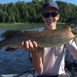
Rainbows are the undisputed bread and butter of this high-altitude fishery. Colorado Parks and Wildlife (CPW) meticulously manages this water, planting upwards of 100,000 fingerlings and catchable-sized trout annually to maintain a robust population. Right now, anglers will encounter two distinct classes of fish. First are the aggressive, recently planted stocker rainbows in the 10 to 14-inch class traveling in hungry, competitive schools. Second are the thick, football-shaped holdovers in the 16 to 20-inch range that have survived previous winters and are aggressively packing on weight.
Sleeper Pick: Snake River Cutthroat and Cutbows
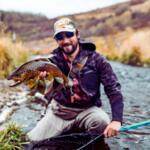
While most visiting anglers are busy catching their limits of stocker rainbows in the shallows, the larger Snake River Cutthroats and hybrid Cutbows are frequently overlooked. These apex predatory fish tend to avoid the chaotic shallow bays, preferring to cruise the deeper drop-offs, submerged channels, and rocky structure where they can efficiently ambush smaller baitfish.
Baitfish & Forage Report
The primary forage base at Vega is heavily dominated by freshwater shrimp, commonly known as scuds, which cling tightly to the establishing submerged vegetation. Midge hatches are also a daily occurrence, providing a protein-rich surface buffet, particularly in the calm morning hours. For the larger, predatory trout, the menu shifts to juvenile suckers and fathead minnows holding near the steep, rocky transitions and dam face.
Pro Tip:Trout holding in the weed lines will have a diet heavily biased toward olive and orange scuds. If you are fly fishing or using a bubble-and-fly rig on a spinning rod, an olive bead-head scud pattern (size 14 or 16) is almost unbeatable in this reservoir.
TACTICAL STRATEGY
Where to Deploy
Location and depth control are everything at Vega right now. Avoid casting blindly into the middle of the lake and focus your efforts on these specific structural zones:
Island Boat Ramp Bay (8-12 ft): This is the premier zone for shore anglers and those seeking high numbers of stocker rainbows. The bay features rapidly establishing weed lines that hold immense concentrations of scuds. Work the outside edges of the submerged vegetation where trout patrol for easy meals.
Oak Point Drop-Offs (15-25 ft): Located on the northeast side of the reservoir, this area features a sharp depth transition. This is the primary travel corridor for trophy Cutbows and Cutthroats hunting minnows. Boat anglers should utilize their sonar to mark suspended fish holding just off the ledge.
Leon-Park Feeder Canal Inlet: The flowing water brings a constant, cooling supply of oxygen and food into the reservoir. The mixing zone where the creek current meets the still water of the lake is a prime ambush point for aggressive, larger trout waiting for food to be delivered to them.
Gear and Presentation
Hardware & Lures
For covering water and triggering reaction strikes from cruising fish, utilize a 1/8oz or 1/4oz Kastmaster spoon in Silver/Blue or classic Gold. If targeting the larger Cutthroats near the Oak Point drop-offs, upscale your presentation to a Rapala Countdown CD05 or CD07 in Rainbow Trout or Brown Trout patterns to mimic juvenile fish. Retrieve with a twitch-and-pause cadence to trigger following predators into striking.
Bait Fishing
For stationary shoreline anglers, scent dispersion is key to drawing fish out of the weeds. Rig a sliding egg sinker (1/4oz to 1/2oz depending on wind conditions) above a barrel swivel, followed by a 24-inch leader of 4lb fluorocarbon. Bait a size 8 baitholder hook with Garlic-scented PowerBait (Chartreuse or Rainbow colors) or a blown-up nightcrawler. The sliding sinker ensures the fish doesn't feel resistance when picking up the bait, while the fluorocarbon leader remains completely invisible in the clear alpine water.
Fly Fishing Tactics
For the long-rod enthusiasts, a 5-weight setup with a floating line and a 9-foot 4X leader is ideal for indicator fishing. Suspend a size 14 bead-head pheasant tail or an olive scud just above the weed tops. If the wind permits, stripping a black or olive Woolly Bugger (size 8) on an intermediate sinking line along the drop-offs can produce violent, arm-jolting strikes from the larger holdover trout.
Timing
The bite is heavily front-loaded during the summer months. You want your lines in the water at first light. The window from dawn until 10:00 AM offers the most aggressive feeding activity and the absolute safest boating conditions. A secondary, shorter bite window occurs at dusk, though evening winds can sometimes complicate access.
Pro Tip:When trolling from a boat, deploy a dodger and spinner rig (like a Wedding Ring spinner tipped with a piece of real nightcrawler) at a speed of 1.2 to 1.5 mph. Keep your gear in the top 10 feet of the water column early in the morning, and use lead core line or downriggers to drop to 15-20 feet as the sun penetrates the water later in the day.
REGULATIONS SNAPSHOT
Vega Reservoir is strictly monitored by CPW wardens to protect the fragile high-altitude ecosystem. Always verify current rules at the Visitor Center upon arrival, but here are the critical baseline regulations for this water:
Regulation Category
Rule Details
Bag & Possession Limits
4 trout in the aggregate per day (Rainbow, Brown, Cutthroat, Cutbow). The total possession limit is 8 fish.
Bait Restrictions
No live fish or minnows are allowed as bait under any circumstances. Artificial lures, dead bait, worms, and scented dough baits (PowerBait) are permitted.
Boating & ANS Inspections
Mandatory Aquatic Nuisance Species (ANS) inspections are required at the Visitor Center before launching any motorized or trailered vessel. Clean, Drain, and Dry all gear.
Park Access
A valid Colorado State Parks vehicle pass is required for entry, in addition to a valid state fishing license for all anglers 16 and older.
REGIONAL ALTERNATIVE
Rifle Gap Reservoir
If the winds are howling off the Grand Mesa, making Vega Reservoir unfishable or unsafe for small craft, pack up your gear and make the hour-long drive north to Rifle Gap Reservoir. Sitting at a significantly lower elevation (around 6,000 feet), Rifle Gap generally offers much warmer, more stable weather conditions when the high country is blown out.
Target Species: Walleye, Yellow Perch, and Brown Trout.
Tactical Approach: Swap your trout gear for walleye tactics. Target the rocky points and the steep face of the dam using 1/4oz lead-head jigs tipped with curly tail grubs or live nightcrawlers. Work the jigs slowly along the bottom in 15 to 30 feet of water, maintaining constant contact with the structure. For Yellow Perch, locate submerged brush piles using electronics and drop small tungsten ice jigs tipped with worm fragments straight down. The shoreline access along the north side of the reservoir is excellent, making it an incredibly easy pivot if you are fishing from the bank and need to salvage your day.
Tight lines!
Editor's Choice: Must-Have Gear
FISHINGSIR Next-Gen Waterproof Chest Waders
★★★★★4.4 (7,370+ reviews)
2-Ply Tech: Upgraded nylon with 2.5x higher density than standard fabrics.
100% Waterproof: Lab-approved intrusion resistance with taped visible seams.
Ultra-Lightweight: Designed for all-day comfort while hunting or fishing.
As an Amazon Associate I earn from qualifying purchases. #ad
Loading forecast...
Live Fishing Conditions: Tides, Weather & Waves
Get real‑time tides, marine weather, swell and solunar activity for each spot so you know exactly when conditions line up for your best chance at a bite.
🎣
Vega Reservoir
Loading coordinates...
🌤️
WEATHER CONDITIONS
--°F
--°C
Loading...
🌡️
Feels Like--°F--°C
💧
Humidity--%
💨
Wind-- mph-- km/h
🧭
Direction--
📊
Pressure-- inHg-- hPa
☀️
UV Index--
🌊
MARINE CONDITIONS
🌊Wave Height
-- ft
-- m
Loading...
🧭Wave Direction
--°
Loading...
⏱️Wave Period
-- s
Loading...
📈Tide Status
-- ft
-- m
Loading...
🌙
LUNAR & SOLUNAR
🌕
Loading...
Illumination: --%
Major Period--:-- - --:----:-- - --:--
Minor Period--:-- - --:----:-- - --:--
🌅Sunrise--:--
🌇Sunset--:--
📅
24-HOUR FORECAST
Loading fishing conditions...
Fishing Spots Map
🎣
Book a Fishing Charter near Vega Reservoir Fishing Report Today 🎣
Local guides & charters. Verified captains, instant booking, best price guaranteed.
There was an error loading the map. Please try refreshing the page.
Info
Local Access & Facilities
Nestled in the rugged, high-altitude terrain of Collbran, Colorado, Vega Reservoir offers seasoned anglers a pristine, remote freshwater experience. This is not a manicured urban fishery; it is a wild, expansive mountain lake where preparation and self-reliance are the keys to a successful expedition. The atmosphere here is quiet and commanding, defined by sweeping valley winds, dramatic elevation changes, and cold, nutrient-rich waters that attract serious boaters and shore casters alike.
Expert captains and traveling anglers are drawn to this location precisely because of its isolation. However, that same isolation demands rigorous logistical planning. With major supply hubs located miles away in towns like Rifle and Cedaredge, every piece of tackle, drop of fuel, and block of ice must be accounted for before you begin your ascent. The reservoir rewards those who respect its remote nature and arrive fully equipped for changing mountain conditions.
Whether you are backing a heavy skiff down one of the local ramps for a dawn patrol or setting up a complex shore-fishing basecamp near the Meadows Group Picnic Area, understanding the lay of the land is critical. Navigating the access points, securing overnight accommodations, and adapting to the strict digital permit systems are all part of the Vega Reservoir experience.
Access & Getting There
Reaching the productive waters of Vega Reservoir requires navigating winding mountain roads that climb significantly in elevation. Traffic is rarely a bottleneck in this remote sector, but weather conditions can drastically alter your travel time. Anglers towing heavy trailers should ensure their braking systems are optimized for steep, sustained descents. The primary approach often brings visitors through Collbran, with the closest staging area being Hanson Ranch, located roughly 6.4 miles from the main water body.
The boat launch situation here is highly functional but strictly utilitarian. There are three primary, unnamed boat ramps located within 2,383 feet to 3,590 feet of the central reservoir hub. Seasoned skippers will appreciate that all three launches offer dedicated trailer parking. However, the ramps completely lack overhead lighting. If you are planning a pre-dawn launch to beat the mid-morning winds, high-lumen headlamps and reliable deck lights are absolute necessities for safe trailer maneuvering.
💡 Captain's Tip: Dark Water Launches
Because none of the three primary boat ramps feature artificial lighting, backing down a trailer before sunrise requires extreme caution. Walk the ramp first to check for slick mud or debris, and use a spotter with a high-powered flashlight to guide your trailer axles safely to the waterline.
Weather contingencies are a critical factor when accessing this high-altitude fishery. Mountain weather changes rapidly, and high winds can turn the open reservoir into a dangerous chop within minutes. The safety protocols explicitly advise checking local conditions prior to launching. If the wind makes boat launching too hazardous, the Meadows Group Picnic Area, located just 1 mile from the center, serves as an excellent, sheltered fallback for shore fishing.
For those driving in from farther out, parking strategy requires some forethought. While trailer parking is available at the ramps, overflow or staging parking is spread out. Round Corral Parking Area in Cedaredge sits 15.5 miles away, while larger public garages and the Rifle Rest Area are over 20 miles out. Always secure your gear and lock your trailer hitches, as the remote nature of these lots means they are largely unmonitored.
Vega Reservoir Pre-Trip Checklist
Facilities & Amenities
The infrastructure surrounding Vega Reservoir is geared toward self-sufficient outdoorsmen rather than casual tourists. The most vital piece of negative knowledge for any visiting angler is the complete absence of local bait and tackle shops in the immediate vicinity. You cannot rely on picking up spare terminal tackle, live bait, or replacement line once you arrive. All provisioning must be completed in larger regional hubs before making the final drive up the mountain.
Similarly, the boat ramps themselves are stripped down to the bare essentials. There are no fish cleaning stations available at the water's edge. Anglers must bring heavy-duty coolers packed with sufficient ice to transport their catch back to camp or home for processing. Additionally, there are no showers or restrooms located directly at the boat launches. Public restrooms are available, but they require a short walk, situated between 1,958 feet and 3,800 feet from the primary access zones.
💡 Captain's Tip: Total Provisioning
Treat this fishery like an offshore expedition. Without local tackle shops, fuel docks, or ice machines at the ramps, you must bring everything you need for the day. Double-check your bilges, pack extra fuel reserves, and ensure your coolers are fully iced before leaving town.
When it comes to lodging, the region offers several high-caliber options tailored to early-rising anglers. Camp7 in Collbran is a highly rated accommodation located just 9 miles from the water. For those approaching from the south, Grand Mesa Lodge in Cedaredge is situated 16.7 miles away and caters specifically to outdoor enthusiasts. Below is a breakdown of key local facilities to help you plan your staging areas.
Facility Name
Type
Distance
Notes
Camp7
Accommodation
9.0 miles
Highly rated, closest formal lodging in Collbran.
Grand Mesa Lodge
Accommodation
16.7 miles
Located in Cedaredge, open daily until 6:00 PM.
Crag Crest Campground
Accommodation
14.1 miles
Managed by Grand Valley RD, excellent rugged alternative.
Hanson Ranch
Parking / Staging
6.4 miles
Closest major parking area to the reservoir.
Rifle Rest Area
Parking
20.9 miles
Good for staging large rigs before the final ascent.
Permits, Regulations & Fees
Fishing and boating at Vega Reservoir fall under the strict jurisdiction of the State Fishing Agency. Conservation is taken seriously in this high-altitude environment to protect the delicate cold-water ecosystem. Anglers are legally required to review all official state sources for current seasonal closures, strict size limits, and species-specific bag limits. Ignorance of the local regulations is never accepted as an excuse by patrolling wardens.
The camping permit system in this region requires specific technological preparation. Nearby federal campgrounds, including Big Creek and Weir and Johnson, operate strictly on a first-come, first-served basis. Visitors must physically arrive at the location to claim a site. Payment is processed entirely through a "Scan and Pay" QR code system linked to the Recreation.gov mobile application.
💡 Local Alert: Digital Permits & Dead Zones
Cellular service around the reservoir and local campgrounds is notoriously poor or entirely nonexistent. You absolutely must download the free Recreation.gov mobile app and set up your payment profile before you leave the highway and lose your signal.
Understanding these digital requirements is essential for a smooth trip. If you arrive at Big Creek—located roughly 11 miles from the reservoir—without the app pre-installed, you will be unable to legally pay for your site. Both Big Creek and Weir and Johnson offer standard non-electric sites, making them ideal for self-contained RVs or traditional tent camping for anglers who don't mind roughing it.
Finally, respect for the surrounding land is paramount. The area features mixed boundaries between federal lands, state parks, and private ranches. Always adhere to posted signage, especially when exploring secondary dirt roads or shorelines. Trespassing on private ranch land to access hidden coves is strictly prohibited and heavily enforced by local authorities.
Events & Seasonal Information
The rhythms of Vega Reservoir are dictated entirely by the harsh and beautiful seasonal shifts of the Colorado mountains. During the peak summer months, the water provides a cool respite, but anglers must be vigilant about afternoon thunderstorms. It is a common local pattern for mornings to be dead calm—perfect for smooth boat launches—only for aggressive trade winds and lightning to roll over the peaks by early afternoon.
During the colder shoulder seasons, the crowds thin out dramatically, offering solitary access to the water. However, these periods require specialized cold-weather gear. The lack of natural windbreaks on the open water means the wind chill can drop significantly, even when the sun is shining. Appropriate footwear with strong traction is mandatory, as the unimproved shorelines and dirt ramps become incredibly slick after seasonal rains or early snowmelts.
For anglers traveling with families or those looking to mix up their outdoor activities, the region offers excellent secondary options. The Meadows Group Picnic Area provides a fantastic, family-friendly venue for shore fishing when the main reservoir is too choppy for small vessels. Additionally, the Mud Hill Spur #1271 trail, located approximately 10.7 miles away, offers a pristine 1.0-mile route dedicated to horseback riding, perfect for off-water days.
Contact Information & Resources
Self-reliance is your best resource when fishing this remote sector of Colorado. Because cell service is highly unreliable, anglers should leave a detailed float plan with family or friends back home. For specific inquiries regarding the Big Creek or Weir and Johnson campgrounds, the managing facility can be reached directly at (928) 537-8888. However, do not expect immediate on-site assistance if you run into mechanical trouble on the water.
Emergency preparedness cannot be overstated. The official safety notes mandate checking weather conditions prior to departure and utilizing proper sun protection, as the high elevation significantly increases UV exposure. Always carry a comprehensive first aid kit, a VHF radio if applicable, and extra provisions in case you are delayed by sudden mountain storms.
For precise locations, real-time conditions, and interactive maps of the boat ramps and parking areas discussed above, consult the live dashboard and nearby spots widgets below.
Our spot reports combine data-driven forecasts with curated local information. The forecast is generated by our proprietary Fishing Score algorithm (0–100%), which analyzes real-time data from Open-Meteo API, validated against NOAA CO-OPS tide gauges and USGS water-monitoring stations. The model weights tide dynamics (35%), wave energy (25%), wind patterns (20%) and time of day (20%)—factors shown to influence fish feeding behavior through marine-biology research and decades of charter log data.
Access, facilities and services information for each fishing spot is sourced from official datasets such as Recreation.gov (RIDB), state park & wildlife agencies, and geospatial providers like Google Maps. These sections undergo scheduled re-validation every 3–6 months to ensure that boat ramps, park access, contact details and local services remain accurate.
Narrative sections (catches, seasonal behavior, local tips) are synthesized from these data sources and refined following the Fishing Reports Today editorial guidelines, combining bibliographic research from ichthyology and oceanography with expert angler experience. Our team reviews reports on a regular basis, while the forecast model itself updates every 6 hours for real-time accuracy.
⚠️ Important: Always verify current local regulations, access restrictions and weather conditions before fishing. These reports are intended as a planning aid, not a guarantee of catches or safety. When in doubt, contact local authorities or park managers listed on the page.
To provide the best experiences, we use technologies like cookies to store and/or access device information. Consenting to these technologies will allow us to process data such as browsing behavior or unique IDs on this site. Not consenting or withdrawing consent, may adversely affect certain features and functions.
Functional Always active
The technical storage or access is strictly necessary for the legitimate purpose of enabling the use of a specific service explicitly requested by the subscriber or user, or for the sole purpose of carrying out the transmission of a communication over an electronic communications network.
Preferences
The technical storage or access is necessary for the legitimate purpose of storing preferences that are not requested by the subscriber or user.
Statistics
The technical storage or access that is used exclusively for statistical purposes.The technical storage or access that is used exclusively for anonymous statistical purposes. Without a subpoena, voluntary compliance on the part of your Internet Service Provider, or additional records from a third party, information stored or retrieved for this purpose alone cannot usually be used to identify you.
Marketing & Affiliates
The technical storage or access is required to create user profiles to send advertising, or to track the user on a website or across several websites for similar marketing purposes, including affiliate tracking for products recommended in our reports.


Leave a Reply