Palisade State Park Fishing Report: Spring Transition
Welcome to the latest guide-level intelligence for Palisade State Park. Nestled in the heart of central Utah, this picturesque reservoir offers a serene, motor-free environment that is perfect for kayaks, float tubes, and shore anglers,. As the surrounding landscape transitions into its vibrant spring colors, the aquatic ecosystem is waking up, providing some of the most consistent and aggressive action of the year. Whether you are targeting heavily stocked trout or looking for a surprise panfish bite, this report delivers the tactical specifics you need to maximize your time on the water.
1. GO/NO-GO STATUS
Verdict: GO
Current conditions are highly favorable for anglers, earning a solid "GO" rating. The water temperature is holding steady around 55 degrees Fahrenheit, which is the absolute optimal metabolic window for our primary cold-water targets.
🎣Nautrek
Private Beta
J
M
R
100+ anglers on the waitlist
The fishing network where your reputation matters.
Find trusted captains, join real trips with cost splitting, and build your Angler Rank. Your spots stay private — you decide who sees your intel.
The reservoir is currently sitting at roughly 45 percent of its maximum capacity. While this lower water level requires a bit of extra caution when navigating the shoreline due to exposed banks, it works to the angler's advantage by concentrating the fish into a smaller, more definable basin. Weather patterns are stable, featuring mostly clear skies with daytime highs reaching the mid-70s and overnight lows in the upper 40s to low 50s. There is currently no ice present on the reservoir. The main launch ramp is fully open, but remember that only electric and non-motorized vessels are permitted,,.
Safety Advisory:
With the lower water levels, pay close attention to submerged structure that may now be dangerously close to the surface.
Spring winds in the canyon can kick up unexpectedly in the late afternoon, altering water conditions rapidly.
Kayak and float tube anglers should always wear a properly fitted personal flotation device, especially when venturing far from the shoreline.
2. SPECIES INTEL
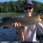
Primary Target: Rainbow and Tiger Trout
Trout are the undisputed kings of Palisade Reservoir. The Rainbow Trout are currently cruising the middle of the water column, aggressively foraging on hatches to recover from the lean winter months. Tiger Trout are exhibiting their notoriously aggressive, predatory behavior, often ambushing smaller baitfish near structural transitions and drop-offs.
Sleeper Pick: Wiper and Mature Goldfish
Most anglers completely overlook the Wiper (a white bass and striped bass hybrid) in this system. These fish travel in packs, feed aggressively on smaller fish and crustaceans, and provide a blistering, drag-peeling fight if you can locate them. Additionally, Palisade has a unique, self-sustaining population of mature goldfish,,. While not a traditional game fish, they grow to impressive sizes here and offer a fun, unexpected bend in the rod, especially for young anglers.
Baitfish Report
The primary forage base right now consists of emerging aquatic insects, small crustaceans, and juvenile panfish. The trout are keyed in on smaller, darting movements. Matching this hatch with downsized, flashy presentations will trigger reaction strikes even when the fish aren't actively feeding.
3. TACTICAL STRATEGY
Where to Find Them
With the water drawn down to 45 percent capacity, the fish have vacated the shallowest coves and are holding tight to the primary drop-offs. Focus your efforts along the deeper water near the dam structure on the south end. For shore anglers, the western shoreline parallel to the hiking trail offers excellent access to a sharp 8-to-12 foot drop-off where trout are patrolling for food. If you are on a float tube or kayak, target the transition zones where the remaining weed beds meet the deeper basin.
Lure Selection
Hardware is outperforming everything else right now. Tie on a 1/4-ounce Jakes Spin-A-Lure or a Thomas Speedy Shiner. The erratic, fluttering action mimics a dying baitfish perfectly. If you prefer casting hard baits, a Rapala Original Floater (Size 5) or a Size 5 Rapala Jigging Rap worked vertically over the drop-offs will trigger aggressive Tiger Trout.
Pro Tip:When using spinning hardware, always attach a small, high-quality barrel swivel 12 inches above your lure. This prevents line twist and allows the spoon to flutter with maximum action on the pause.
Color Patterns
Water clarity is currently slightly stained from spring runoff and wind mixing. Gold and red combinations are crushing it, as the metallic flash cuts through the turbidity. If the sun is high and bright, switch to a silver/blue or a classic rainbow trout pattern to reflect maximum light.
Bait and Rigging
Traditional bait anglers are finding highly consistent success using garlic or cheese-scented dough baits. Rig this on a slip-sinker setup: thread a 1/2-ounce egg sinker onto your main line, tie on a barrel swivel, and attach an 18-inch light fluorocarbon leader (4-to-6 pound test) ending in a Size 16 treble hook. This allows the buoyant dough bait to float just above the bottom vegetation. Alternatively, a live nightcrawler suspended 4 to 6 feet under a clear casting bubble is a reliable producer when the surface ripple hides the float.
Optimal Timing
The first two hours of daylight and the last hour before sunset are critical. Not only is the bite most aggressive during these low-light windows, but fishing early or late ensures you avoid the midday armada of recreational paddleboarders, kayakers, and swimmers who can easily spook fish in this small reservoir,.
Pro Tip:For fly anglers, the evening bite is spectacular right now. Strip an Olive or Black Woolly Bugger (Size 8) on an intermediate sinking line using short, erratic strips to imitate a fleeing leech or damselfly nymph. Wet flies and streamers are historically top producers at Palisade.
4. REGULATIONS SNAPSHOT
To ensure this fishery remains healthy for future generations, please adhere strictly to the local regulations enforced by the Utah Division of Wildlife Resources. A valid Utah fishing license is required for all anglers aged 12 and older.
Species
Daily Bag Limit
Size Restrictions
Season Status
Trout (Rainbow, Tiger, Cutthroat)
4 fish (in combination),
No size restrictions
Open Year-Round
Wiper
3 fish
No size restrictions
Open Year-Round
Black Bass (Largemouth/Smallmouth)
6 fish
Any size
Open Year-Round
Boating Restriction: Palisade Reservoir is strictly limited to electric trolling motors or non-motorized watercraft. Internal combustion engines are completely prohibited,,,.
5. REGIONAL ALTERNATIVE
If Palisade State Park is blown out by heavy canyon winds, or if you are simply looking for a completely different angling experience, Yuba State Park is an outstanding backup plan located just a short drive away.
Yuba Reservoir is a massive, warm-water fishery that provides an excellent contrast to Palisade's cold-water trout focus. The primary targets here are Walleye, Northern Pike, and Channel Catfish,. Currently, the Oasis Campground boat ramp is fully open, though anglers should be aware that the Painted Rocks ramp is closed due to low water conditions.
Tactical Approach for Yuba: To locate early-season Walleye, drift troll the main basin using a 1-ounce bottom bouncer paired with a crawler harness or a chartreuse soft plastic grub. Keep your speed between 0.8 and 1.2 mph. If you want to target the aggressive Northern Pike, move toward the flooded brush and rocky points near the inlet, casting large, flashy spoons or 6-inch soft plastic swimbaits.
Pro Tip:When targeting Northern Pike at Yuba Reservoir, always use a 12-inch wire leader or heavy fluorocarbon leader (60-pound test). Their razor-sharp teeth will instantly slice through standard monofilament lines, resulting in lost fish and lost tackle.
Tight lines!
Editor's Choice: Must-Have Gear
FISHINGSIR Next-Gen Waterproof Chest Waders
★★★★★4.4 (7,370+ reviews)
2-Ply Tech: Upgraded nylon with 2.5x higher density than standard fabrics.
100% Waterproof: Lab-approved intrusion resistance with taped visible seams.
Ultra-Lightweight: Designed for all-day comfort while hunting or fishing.
As an Amazon Associate I earn from qualifying purchases. #ad
Loading forecast...
Live Fishing Conditions: Tides, Weather & Waves
Get real‑time tides, marine weather, swell and solunar activity for each spot so you know exactly when conditions line up for your best chance at a bite.
🎣
Palisade State Park, Utah
Loading coordinates...
🌤️
WEATHER CONDITIONS
--°F
--°C
Loading...
🌡️
Feels Like--°F--°C
💧
Humidity--%
💨
Wind-- mph-- km/h
🧭
Direction--
📊
Pressure-- inHg-- hPa
☀️
UV Index--
🌊
MARINE CONDITIONS
🌊Wave Height
-- ft
-- m
Loading...
🧭Wave Direction
--°
Loading...
⏱️Wave Period
-- s
Loading...
📈Tide Status
-- ft
-- m
Loading...
🌙
LUNAR & SOLUNAR
🌕
Loading...
Illumination: --%
Major Period--:-- - --:----:-- - --:--
Minor Period--:-- - --:----:-- - --:--
🌅Sunrise--:--
🌇Sunset--:--
📅
24-HOUR FORECAST
Loading fishing conditions...
Fishing Spots Map
🎣
Book a Fishing Charter near Palisade State Park, Utah Fishing Report Today 🎣
Local guides & charters. Verified captains, instant booking, best price guaranteed.
There was an error loading the map. Please try refreshing the page.
Info
Local Access & Facilities
The fishery surrounding Palisade and the broader Grand Valley represents a unique convergence of high-desert topography and powerful river systems. Situated where the Colorado River winds beneath the imposing Book Cliffs, this location offers anglers a distinct alternative to high-alpine reservoirs. The atmosphere here is defined by the stark contrast between the arid, red-rock landscape and the lush agricultural belt of orchards and vineyards fed by the river. For the serious angler, this is technical water that demands respect for currents and an understanding of seasonal flows, particularly near the confluence with the Gunnison River.
Unlike the manicured marinas of large impoundments, the access here is rugged and river-centric. The backdrop is dominated by the Little Book Cliffs Wilderness Study Area, providing a dramatic, scenic isolation despite being relatively close to the I-70 corridor. The water here can range from clear and manageable to swift and turbid depending on runoff and release schedules. This guide details the logistical realities of launching, supplying, and navigating the local infrastructure necessary for a successful campaign on these waters.
💡 Captain's Tip: Seasonal Heat Management
The Grand Valley is high desert, and summer temperatures frequently exceed 105°F. Plan your outings for "dawn patrol" or late evening. If you are dry camping at North Fruita Desert, be aware there is zero shade and no water hookups—hydration strategy is critical for both crew and safety gear.
Access & Getting There
Access to the primary fishing grounds in Palisade is streamlined by the proximity of Interstate 70, which serves as the main artery through the region. Anglers towing vessels should utilize Exit 19 (Fruita) or Exit 62 (Debeque) depending on their specific launch target, though the core access for this spot is directly adjacent to the town of Palisade. Traffic is generally manageable, but the I-70 corridor can see congestion during peak travel weekends. The drive along the river offers multiple vantage points to check water clarity before committing to a launch.
River Bend Park Boat Ramp is the primary launch facility serving this specific coordinate. Located approximately 0.8 miles from the town center, this ramp provides direct access to the Colorado River. While the ramp includes trailer parking, seasoned skippers know that river levels fluctuate significantly; checking the mud line and current speed at the ramp is essential before offloading. A second option, the Palisade Rim Boat Ramp, is located roughly 1.8 miles away. Both facilities are functional but lack the extensive breakwaters found in coastal harbors, meaning launching and retrieving require competent boat handling in moving water.
For those strictly fishing from the bank or scouting the water, Free Public Parking is available on Kluge Avenue, a mere 485 feet from key access points. This lot is rated highly for accessibility but does not offer dedicated trailer spaces. If you are running a drift boat or raft and need to shuttle vehicles, the Orchard Mesa Park and Ride (approx. 9.4 miles away) serves as a viable rendezvous point for leaving a second vehicle, although it is too far for a primary staging area.
💡 Captain's Tip: Launch Ramp Currents
The River Bend Park Boat Ramp puts you directly into the river's flow. Ensure your engine is warmed up and reliable before backing down. During spring runoff, the current here can complicate solo launching; having a competent deckhand to handle dock lines is highly recommended.
Palisade State Park, Utah Pre-Trip Checklist
Facilities & Amenities
The infrastructure in the Grand Valley caters heavily to outdoor recreation, but services are spread out across the towns of Palisade, Grand Junction, and Fruita. Unlike centralized marinas, you will need to visit specific specialty shops for gear. Western Anglers Fly Shop, located 11.9 miles away on Main Street in Grand Junction, is the premier hub for fly fishermen targeting river species. Note their operating hours: they open at 9:00 AM, which is too late for anglers wanting an early start. You must secure your leaders, tippet, and flies the day before.
For conventional anglers requiring hardware, Dynamic Lures is located 12.6 miles away in Grand Junction. They specialize in lure manufacturing and offer specific insights into local forage. Similar to the fly shop, they open at 9:00 AM and are closed on weekends, so logistical planning is required. There is no fuel dock on the water; all vessels must be fueled at highway stations prior to arrival. Heavy provisioning should be done in Grand Junction before heading to the launch or campsite.
Lodging options vary drastically in style and utility. For the angler who requires power, water, and proximity to the launch, Palisade Basecamp RV Resort is the strategic choice. Located just 1.2 miles from the water, it offers full amenities and allows for a quick transition from sleep to fishing. Conversely, for those seeking solitude and a rugged experience, the North Fruita Desert Campground (BLM) offers a true high-desert experience. However, this is "negative knowledge" territory: this campground has no water, no electricity, and no trash collection. It is strictly pack-in, pack-out dry camping located 24.4 miles from the fishing spot. It is designed primarily for mountain bikers but serves as a viable base camp for self-sufficient anglers with off-road capable vehicles.
Facility Name
Type
Distance
Key Features/Notes
River Bend Park
Boat Ramp
0.8 mi
Primary river access; trailer parking available.
Palisade Basecamp
RV Resort
1.2 mi
Full hookups; closest lodging to launch.
Western Anglers
Fly Shop
11.9 mi
Opens 9 AM; specialized fly gear.
North Fruita Desert
Campground
24.4 mi
BLM managed; No water/power; Vault toilets only.
Permits, Regulations & Fees
Navigating the regulatory environment here requires attention to both state and federal jurisdictions. The primary fishing regulations are enforced by the State Fishing Agency, and valid licenses are mandatory for all anglers. The Bureau of Land Management (BLM) oversees much of the surrounding terrain, including the North Fruita Desert Campground and the Little Book Cliffs Wilderness Study Area (WSA). Anglers venturing ashore or accessing remote stretches of the river through these lands must adhere to strict "Leave No Trace" principles.
The Little Book Cliffs WSA is a sensitive habitat known for its wild horse herd and cultural artifacts from the Fremont Culture. Special restrictions apply here to protect these resources. For instance, the Coal Canyon trailhead access is closed to motorized traffic from December 1 through May 30 to protect wintering wildlife. If your fishing plan involves hiking into remote canyon waters, verify that your route does not cross into restricted zones. Additionally, much of the riverbank in Palisade borders private orchards and vineyards. Local etiquette demands strict respect for property lines; never cross private agricultural land to access the river without explicit permission.
Camping fees at the BLM sites are used to maintain the trail systems and basic facilities (vault toilets). While permits are not explicitly listed as required for entry to the general fishing area, the North Fruita Desert campsites require reservations and fees. The refund policy is strict: refunds are not given for undesirable weather, which is a crucial consideration given the area's exposure to intense heat and sudden storms.
Events & Seasonal Information
The fishing calendar in the Grand Valley is dictated by the hydrological cycle of the Colorado River. Spring brings runoff, which can turn the river high and muddy, making float fishing challenging and wading dangerous. The "sweet spots" for angling are typically the post-runoff window in early summer and the stable flows of autumn. Summer fishing is defined by the heat; with average annual precipitation under 10 inches and temperatures soaring, mid-day fishing is often unproductive and physically draining.
The area is also a hub for outdoor events, particularly mountain biking and running festivals centered around the 18 Road trail system near the campgrounds. During these events, the Lower Campground at North Fruita Desert serves as a staging area, and campsites may be closed or extremely crowded. Anglers seeking tranquility should check the local event calendar for races to avoid the influx of crowds. The Little Book Cliffs area remains quieter, offering solitude for those willing to hike.
💡 Captain's Tip: Shop Hours & Logistics
Local tackle shops like Dynamic Lures and Western Anglers operate on standard retail hours (9:00 AM - 5:30 PM) and have weekend closures (Dynamic Lures is closed Sat/Sun). Do not rely on buying bait or replacement lures on the morning of a weekend trip. Stock up mid-week.
Contact Information & Resources
For the most current information on river conditions, campground status, and land access, the primary point of contact is the BLM Grand Junction Field Office. They can be reached at (970) 244-3000 or via email at blmcogjwebmail@blm.gov. They manage the specific alerts for the Little Book Cliffs WSA and the North Fruita Desert recreation area.
In terms of safety, this is a self-reliant zone. Cell service can be spotty in the canyons and the Book Cliffs area. Always file a float plan with a reliable contact if you are drifting the river. There are no on-water emergency patrols like the Coast Guard; rescue is a land-based operation coordinated by local county sheriff departments. For those staying at the North Fruita Desert Campground, the volunteer host is typically on-site during spring and fall at the north end of the upper campground for basic assistance.
For precise locations of boat ramps, real-time weather data, and detailed maps of the river bends, consult the live dashboard and interactive widgets below.
Our spot reports combine data-driven forecasts with curated local information. The forecast is generated by our proprietary Fishing Score algorithm (0–100%), which analyzes real-time data from Open-Meteo API, validated against NOAA CO-OPS tide gauges and USGS water-monitoring stations. The model weights tide dynamics (35%), wave energy (25%), wind patterns (20%) and time of day (20%)—factors shown to influence fish feeding behavior through marine-biology research and decades of charter log data.
Access, facilities and services information for each fishing spot is sourced from official datasets such as Recreation.gov (RIDB), state park & wildlife agencies, and geospatial providers like Google Maps. These sections undergo scheduled re-validation every 3–6 months to ensure that boat ramps, park access, contact details and local services remain accurate.
Narrative sections (catches, seasonal behavior, local tips) are synthesized from these data sources and refined following the Fishing Reports Today editorial guidelines, combining bibliographic research from ichthyology and oceanography with expert angler experience. Our team reviews reports on a regular basis, while the forecast model itself updates every 6 hours for real-time accuracy.
⚠️ Important: Always verify current local regulations, access restrictions and weather conditions before fishing. These reports are intended as a planning aid, not a guarantee of catches or safety. When in doubt, contact local authorities or park managers listed on the page.
To provide the best experiences, we use technologies like cookies to store and/or access device information. Consenting to these technologies will allow us to process data such as browsing behavior or unique IDs on this site. Not consenting or withdrawing consent, may adversely affect certain features and functions.
Functional Always active
The technical storage or access is strictly necessary for the legitimate purpose of enabling the use of a specific service explicitly requested by the subscriber or user, or for the sole purpose of carrying out the transmission of a communication over an electronic communications network.
Preferences
The technical storage or access is necessary for the legitimate purpose of storing preferences that are not requested by the subscriber or user.
Statistics
The technical storage or access that is used exclusively for statistical purposes.The technical storage or access that is used exclusively for anonymous statistical purposes. Without a subpoena, voluntary compliance on the part of your Internet Service Provider, or additional records from a third party, information stored or retrieved for this purpose alone cannot usually be used to identify you.
Marketing & Affiliates
The technical storage or access is required to create user profiles to send advertising, or to track the user on a website or across several websites for similar marketing purposes, including affiliate tracking for products recommended in our reports.


Leave a Reply