Parrie Creek Lake, Muncie, IN Fishing Report Today 🎣
8 months ago · Updated 3 weeks ago
Prairie Creek Reservoir Fishing Report
Welcome to your premier tactical guide for tackling Prairie Creek Reservoir in Muncie, Indiana. As a sprawling 1,275-acre water supply reservoir with a maximum depth of 30 feet, this body of water offers a true big-lake experience right in the heart of Delaware County. Whether you are chasing stocked walleye, hunting bucketmouth bass, or looking for a relaxing day pulling on heavy catfish, this comprehensive report delivers the actionable intelligence you need to maximize your time on the water.
GO/NO-GO STATUS
Verdict: CAUTION
Current seasonal transitions are bringing volatile weather patterns to the region. With ambient air temperatures hovering in the mid-50s and heavy overcast skies, the primary concern for boaters is the wind. We are currently seeing stiff North winds sustaining at 16 mph, with gusts pushing past 24 mph. Because Prairie Creek is a relatively open, wind-swept reservoir, a sustained North wind will create significant chop, particularly on the main lake and southern basin.
From the editor
Tired of fishing with strangers you can’t trust?
Nautrek is the first social network for serious anglers — verified partners, real trips, cost splitting and intel sharing without burning your spots. Private beta now open.
Currently, the atmospheric pressure is sitting around 29.94 inHg. This steady, slightly lower pressure combined with heavy cloud cover creates an ideal low-light feeding environment, meaning the fish will be less skittish and more willing to roam away from heavy cover. However, safety must come first. If you are launching a smaller vessel or a kayak, it is highly advisable to tuck into the protected northern coves or heavily wooded shorelines to break the wind. Larger bass boats and deep-V aluminum hulls will handle the main lake chop, but utilizing a heavy anchor or a GPS spot-lock trolling motor will be essential for boat control. Always wear your USCG-approved personal flotation device, especially when navigating whitecaps.
SPECIES INTEL
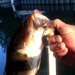
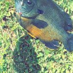
Primary Target: Walleye and Largemouth Bass
Prairie Creek Reservoir is a multi-species powerhouse, but it is most famous for its thriving walleye population. The Indiana Department of Natural Resources (DNR) has maintained a robust stocking program here for decades, making it one of the premier walleye destinations in central Indiana. Alongside the walleye, largemouth bass are highly active during the spring transition, aggressively feeding in the shallows before the heat of summer pushes them into deep thermal refuges.
Sleeper Pick: Channel Catfish
While the fiberglass boats are racing around chasing bass and walleye, the savvy local angler knows that Prairie Creek harbors an exceptional, often overlooked channel catfish population. These whiskered brawlers provide incredibly reliable action, particularly for bank anglers or those looking to anchor up and soak baits along the drop-offs.
Baitfish Report: Gizzard Shad
The forage base in Prairie Creek is overwhelmingly dominated by gizzard shad. This is the most critical piece of intelligence for your lure selection: if your presentation does not mimic a shad, you are leaving fish on the table. The shad are currently schooling tightly, and the strong North winds will push these bait balls against the southern and southwestern shorelines.
TACTICAL STRATEGY
Where to Find the Fish
With the current North wind, the fundamental strategy is to fish the wind-blown banks. Baitfish are poor swimmers and get easily pushed by surface currents. Focus your efforts on the southern points and the gradual drop-offs near the dam. For largemouth bass, target the emerging weedlines and isolated wood cover on the points. Look for areas where the bottom composition transitions from clay to rock in the 8 to 12-foot depth range. Walleye will be patrolling the slightly deeper outside weed edges, waiting to ambush shad that get disoriented in the chop.
Pro Tip:When fishing wind-blown points, always position your boat in the deeper water and cast shallow, bringing your lure back with the wind. This mimics the natural movement of baitfish being swept off the shallow flats into deeper water.
Reading the Water and Electronics
If you are utilizing modern sonar or forward-facing electronics, spend your first 30 minutes graphing the 15 to 20-foot transition zones before making a cast. You are looking for dense, cloud-like returns indicating schools of gizzard shad. Where you find the bait, the walleye and bass will be shadowing closely below and behind the pods.
Lure and Bait Selection
To capitalize on the shad-heavy diet, your artificial presentations must be dialed in perfectly. For largemouth bass, tie on a 3/8oz white or silver swim jig paired with a pearl paddletail trailer. Work this setup aggressively through the shallow emergent cover. If the fish are holding slightly deeper on the drop-offs, a medium-diving crankbait like a Rapala Shad Rap #7 in a natural shad or silver/black back pattern is deadly.
For walleye, a 1/4oz chartreuse or white jig head tipped with a 3-inch white curly tail grub or a live minnow will produce consistent strikes. Hop the jig methodically along the bottom near the 12 to 15-foot transition zones.
If you are targeting our sleeper pick, the channel catfish, anchor up near the deeper outside bends or the gradual drop-offs by the dam. Use a standard slip-sinker rig with a 1/2oz egg weight. Bait your circle hooks with fresh cut shad or a heavy glob of nightcrawlers. Keep the bait pinned just inches off the bottom.
Timing the Bite
Under heavy overcast skies, the traditional dawn and dusk windows are extended, meaning fish may feed actively throughout the day. However, solunar data indicates a peak feeding window occurring mid-afternoon, roughly between 2:00 PM and 5:00 PM. If the wind begins to lay down in the late afternoon, be prepared for a flurry of shallow feeding activity.
Pro Tip:For shore anglers utilizing the bank permits, focus your efforts near the dam on the south end or the riprap banks. The rocks hold heat and attract small forage, which in turn brings the predatory bass and catfish within casting distance. A simple slip-bobber rig set at 4 to 6 feet with a live minnow is a highly effective, low-snag presentation from the bank.
REGULATIONS SNAPSHOT
Prairie Creek Reservoir has unique local regulations because it is managed by the City of Muncie Parks and Recreation Department, though state fishing laws still apply. Please note that a specific Prairie Creek Bank Permit is required to fish from the shore, and a Launch Permit is required for all vessels. These can be purchased at the marina or park office.
Species
Minimum Size Limit
Daily Bag Limit
Walleye
16 inches
6 per day
Largemouth Bass
14 inches
5 per day
Channel Catfish
No minimum size
10 per day
Crappie (Black/White)
No minimum size
25 per day
Critical Local Boating Rules:
Speed Limits: The reservoir enforces a strict 20 MPH speed limit during daylight hours, which drops to 10 MPH between sunset and sunrise.
No Wake Zones: Idle speed only is strictly enforced within 200 feet of the shoreline.
Restricted Access: All docks on the reservoir are privately leased; fishing from them or docking on them without permission is strictly prohibited.
REGIONAL ALTERNATIVE
If the strong North winds make Prairie Creek Reservoir unfishable or unsafe for your vessel, Summit Lake (located in Summit Lake State Park, Henry County) is your premier backup destination. Spanning roughly 800 acres, Summit Lake offers a more protected, quieter environment. The lake enforces an idle-speed-only rule for outboard motors, making it a haven for kayak anglers and small boat operators who want to escape the heavy chop.
At Summit Lake, shift your focus to the abundant submerged timber and distinct weed edges. The crappie and largemouth bass fishing here is exceptionally consistent. Downsize your tackle to 1/16oz or 1/8oz marabou jigs in chartreuse or pink, and work them slowly around the standing timber for a guaranteed stringer of panfish. Summit Lake provides a fantastic, low-stress alternative when the big water gets too rough.
Tight lines!
Editor's Choice: Must-Have Gear
FISHINGSIR Next-Gen Waterproof Chest Waders
★★★★★4.4 (7,370+ reviews)
2-Ply Tech: Upgraded nylon with 2.5x higher density than standard fabrics.
100% Waterproof: Lab-approved intrusion resistance with taped visible seams.
Ultra-Lightweight: Designed for all-day comfort while hunting or fishing.
As an Amazon Associate I earn from qualifying purchases. #ad
Loading forecast...
Live Fishing Conditions: Tides, Weather & Waves
Get real‑time tides, marine weather, swell and solunar activity for each spot so you know exactly when conditions line up for your best chance at a bite.
🎣
Parrie Creek Lake, Muncie, IN
Loading coordinates...
🌤️
WEATHER CONDITIONS
--°F
--°C
Loading...
🌡️
Feels Like--°F--°C
💧
Humidity--%
💨
Wind-- mph-- km/h
🧭
Direction--
📊
Pressure-- inHg-- hPa
☀️
UV Index--
🌊
MARINE CONDITIONS
🌊Wave Height
-- ft
-- m
Loading...
🧭Wave Direction
--°
Loading...
⏱️Wave Period
-- s
Loading...
📈Tide Status
-- ft
-- m
Loading...
🌙
LUNAR & SOLUNAR
🌕
Loading...
Illumination: --%
Major Period--:-- - --:----:-- - --:--
Minor Period--:-- - --:----:-- - --:--
🌅Sunrise--:--
🌇Sunset--:--
📅
24-HOUR FORECAST
Loading fishing conditions...
Fishing Spots Map
🎣
Book a Fishing Charter near Parrie Creek Lake, Muncie, IN Fishing Report Today 🎣
Local guides & charters. Verified captains, instant booking, best price guaranteed.
There was an error loading the map. Please try refreshing the page.
Info
Local Access & Facilities
Fishing the waters of Parrie Creek Lake and the surrounding Muncie, Indiana waterways offers a distinct Midwestern angling experience that blends accessible urban fishing with the rugged charm of the Hoosier heartland. This fishery is characterized by its dual nature: the immediate convenience of the White River flowing through town and the expansive, boat-friendly waters of the nearby reservoir system. For the seasoned angler, this location presents a tactical puzzle of water levels, seasonal shifts, and diverse structure, ranging from manicured shorelines near the university to the timber-laden coves of the reservoir.
The atmosphere here is deceptively quiet. While the city of Muncie hums in the background, the water itself demands a serious approach, particularly for those targeting the region's bass and panfish populations. Unlike the high-pressure, commercialized fisheries of the south, Parrie Creek Lake retains a local, almost intimate vibe. It is a place where local knowledge reigns supreme, and the difference between a skunked livewell and a limit catch often comes down to understanding the subtle transitions in bottom composition and the specific cadence of the local forage.
For the expert captain or traveling pro, the primary draw here is the opportunity to work both power and finesse techniques in a single day. The layout allows for dawn patrol launches on the reservoir followed by technical shore approaches near the city center. While the amenities are sufficient, they require logistical foresight. This is not a "show up and find it" destination; it rewards the angler who maps out their bait stops, launch windows, and trailer parking well before the hitch is locked.
Access & Getting There
Navigating to the primary fishing grounds of Parrie Creek Lake and the greater Muncie area is generally straightforward, though it requires navigating a mix of state highways and local city streets. The central access corridor is typically via the main arteries into Muncie, where traffic is manageable outside of university rush hours. Experienced haulers should be mindful of the urban layout when towing larger rigs toward the city center spots. The transition from the highway to the water can be deceptively quick, so having your route plotted to avoid tight turnaround situations in the downtown grid is essential for those with 20-foot-plus vessels.
💡 Captain's Tip: Launch Logistics
The primary launch point at Prairie Creek Boat Ramp is located approximately 7.1 miles from the city center. While the ramp is serviceable, seasoned skippers know to prep their gear in the staging lane, as the ramp area can become a bottleneck during peak weekend mornings.
The crown jewel for boaters is the Prairie Creek Boat Ramp. This facility is the primary vein for getting hulls into the water. The ramp is functional and allows for trailer parking, which is a critical asset in this region. However, the data indicates a distinct lack of amenities at the ramp itself. There is no lighting, which means early morning launches requires your own illumination. Backing down a dark ramp in the pre-dawn hours requires confidence and a well-checked trailer light system. Furthermore, the absence of a fish cleaning station means catch-and-release is the most convenient option, or you must be prepared to transport your catch on ice for processing at home.
For those looking to fish the urban stretches or access the water without a boat, parking requires a different strategy. The area offers several lots, such as the 601 South High Street Parking and the Health Professions Building Parking. These locations are paved and boast high ratings, but they are designed primarily for standard vehicles. If you are towing, these urban lots are likely non-starters. The Ball State University Hotel Parking is another option about 1.3 miles from the central coordinate, but access may be restricted or tight. The savvy angler targeting shore spots here travels light, perhaps with a truck bed setup rather than a trailer, to maximize mobility between these urban access points.
Weather plays a significant role in access here. Indiana storms can move in rapidly, altering the viability of the boat ramp. High winds can make the open water of the reservoir choppy and difficult to navigate for smaller aluminum craft. Conversely, heavy rains can muddy the river sections near town, blowing out the visibility and making finesse presentations futile. Always check the wind direction relative to the ramp orientation; a strong crosswind at the Prairie Creek Boat Ramp can make solo launching a test of patience and skill.
Parrie Creek Lake, Muncie, IN Pre-Trip Checklist
Facilities & Amenities
The infrastructure surrounding Parrie Creek Lake caters to the self-sufficient angler. You will not find a sprawling marina complex with fuel docks and concierge service here. Instead, the area relies on a network of independent shops and services that are high in quality but spread out geographically. Understanding where to get your supplies is as important as knowing where the fish are holding. The local economy supports the sport, but it operates on a town-based model rather than a water-based one.
For tackle and immediate gear needs, JBC Outfitters is the undisputed hub for serious anglers. Located just 1.1 miles from the central fishing zone, this shop is rated highly by the community. With operating hours starting at 10:00 AM on most days, it is not a pre-dawn stop, but rather the place to go for mid-day re-rigging or to gather local intel on what colors are producing. For live bait, specifically worms and organic presentations, you may need to travel further. Wolfe's Worm Shack is a legendary spot about 18.1 miles out, and Hook Em Bait and Tackle is roughly 22.1 miles away. These distances imply that bait acquisition should be part of your drive-in strategy, not a last-minute errand.
Facility Name
Type
Distance
Key Notes
JBC Outfitters
Tackle Shop
1.1 miles
Opens 10 AM. High-end gear focus.
Wolfe's Worm Shack
Bait Shop
18.1 miles
Traditional live bait. Closed Mon-Wed.
Hook Em Bait and Tackle
Bait Shop
22.1 miles
Opens 8 AM. Reliable stock.
Indy Fly Guide Service
Charter
21.1 miles
Specialized fly fishing trips.
When it comes to lodging, the area leans heavily towards the outdoor experience, which aligns perfectly with the multi-day angler's mindset. Mounds State Park Family Campgrounds, located approximately 13.5 miles away, offers a robust basecamp with a 4.6-star rating. Staying here allows for easy access to the water while providing the space needed to charge boat batteries and prep gear. For a more private experience, Klearwater Lake offers accommodation just under 10 miles from the spot. The Kenny Irwin Jr Memorial Camp is another highly-rated option, though further out at 23.3 miles. These facilities are generally well-maintained, catering to families and sportsmen alike.
💡 Captain's Tip: The "Negative" Check
Be keenly aware of what is missing. The Prairie Creek Boat Ramp has no restrooms and no showers. Plan your biological breaks accordingly before leaving the civilized areas of Muncie. Additionally, there is no fuel dock on the water; ensure your tanks are topped off at a highway station before you back down the ramp.
For those seeking guided expertise, the region is serviced by a few dedicated operators. Indy Fly Guide Service operates out of Anderson, roughly 21 miles away, and offers a specialized approach that can be deadly in the local river systems. Another listed operator, Bass Fishing Musician, appears in the data but is based at a significant distance or potentially operates seasonally; verify their current local availability before booking. The local charter scene is small, meaning booking well in advance is necessary during the prime spring and fall windows.
Permits, Regulations & Fees
Fishing in Indiana waters requires strict adherence to state regulations managed by the State Fishing Agency. While the specific JSON data indicates that no special permits are required beyond the standard state license for this specific spot scan, expert anglers know that complacency leads to citations. A valid Indiana fishing license is non-negotiable and must be carried at all times. The state is vigilant about conservation, and game wardens frequent the popular access points, including the Prairie Creek Boat Ramp.
The regulatory environment here focuses on sustainable harvest and the protection of the waterway's ecological balance. While the data suggests that fees are not required for the specific boat ramp listed, it is always prudent to carry small denominations of cash. Local municipalities often change parking fee structures seasonally, and automated kiosks may be down. Being prepared prevents a wasted trip. Furthermore, while there are no specific "environmental alerts" currently detected, the savvy angler always inspects their hull for invasive species. Indiana takes aquatic invasive species transport seriously; clean, drain, and dry your vessel before and after every launch.
Respect for the land is paramount, especially when accessing shore spots near private property or university grounds. The "Kapu" concept of sacredness may be Hawaiian, but the principle applies universally: treat the shoreline with reverence. Do not block private driveways near the urban access points, and ensure all trash—especially monofilament line—is packed out. The relationship between anglers and the local property owners is delicate; maintaining access depends on the collective behavior of the fishing community.
Events & Seasonal Information
The fishing calendar at Parrie Creek Lake follows the classic Midwestern four-season rhythm. Spring brings the pre-spawn aggression, drawing anglers to the shallows and the creek mouths. This is often the busiest time at the Prairie Creek Boat Ramp, where the lack of lighting becomes a factor as boats jockey for position well before sunrise. Summer settles into a pattern of early morning and late evening bites, with the mid-day heat driving fish deep or into the thickest cover available. The urban heat island effect can warm the river sections faster, occasionally extending the active feeding windows in the shoulder seasons.
Fall is the sleeper season here. As the recreational boat traffic from the university crowd dies down, the water cools, and the fish gorge for winter. This is when the local experts target trophy-class fish. The boat ramp traffic thins out, and the solitude allows for a more methodical dissection of the lake's structure. Winter fishing is weather-dependent; ice conditions vary wildly from year to year, so checking immediate local reports is critical before attempting any hard-water angling.
💡 Captain's Tip: Timing the Wind
In this region, the wind often picks up significantly by 10:00 AM. For the best topwater action and easiest boat control, plan your launch for first light. By noon, the open stretches of the water can become a chop-fest, making precision boat positioning a challenge.
Contact Information & Resources
For the most current information on water levels and ramp conditions, reliance on self-reporting and real-time observation is often necessary. However, for emergencies or official inquiries, the local authorities should be your first point of contact. While specific harbor master numbers are not provided for this inland location, the Mounds State Park office (765-642-6627) can often serve as a proxy for general regional conditions and camping availability.
Safety is the sole responsibility of the captain. With the nearest major medical facilities located in Muncie proper, response times to the water can be rapid, but on-water assistance is not guaranteed. Carry a fully charged VHF radio or a reliable cell phone, as coverage is generally good in this area. Always file a float plan with a contact on land, especially when fishing the expansive reservoir sections alone.
For precise locations, real-time weather overlays, and detailed topography of the boat ramps and bait shops mentioned, consult the live dashboard and interactive maps below.
Our spot reports combine data-driven forecasts with curated local information. The forecast is generated by our proprietary Fishing Score algorithm (0–100%), which analyzes real-time data from Open-Meteo API, validated against NOAA CO-OPS tide gauges and USGS water-monitoring stations. The model weights tide dynamics (35%), wave energy (25%), wind patterns (20%) and time of day (20%)—factors shown to influence fish feeding behavior through marine-biology research and decades of charter log data.
Access, facilities and services information for each fishing spot is sourced from official datasets such as Recreation.gov (RIDB), state park & wildlife agencies, and geospatial providers like Google Maps. These sections undergo scheduled re-validation every 3–6 months to ensure that boat ramps, park access, contact details and local services remain accurate.
Narrative sections (catches, seasonal behavior, local tips) are synthesized from these data sources and refined following the Fishing Reports Today editorial guidelines, combining bibliographic research from ichthyology and oceanography with expert angler experience. Our team reviews reports on a regular basis, while the forecast model itself updates every 6 hours for real-time accuracy.
⚠️ Important: Always verify current local regulations, access restrictions and weather conditions before fishing. These reports are intended as a planning aid, not a guarantee of catches or safety. When in doubt, contact local authorities or park managers listed on the page.
To provide the best experiences, we use technologies like cookies to store and/or access device information. Consenting to these technologies will allow us to process data such as browsing behavior or unique IDs on this site. Not consenting or withdrawing consent, may adversely affect certain features and functions.
Functional Always active
The technical storage or access is strictly necessary for the legitimate purpose of enabling the use of a specific service explicitly requested by the subscriber or user, or for the sole purpose of carrying out the transmission of a communication over an electronic communications network.
Preferences
The technical storage or access is necessary for the legitimate purpose of storing preferences that are not requested by the subscriber or user.
Statistics
The technical storage or access that is used exclusively for statistical purposes.The technical storage or access that is used exclusively for anonymous statistical purposes. Without a subpoena, voluntary compliance on the part of your Internet Service Provider, or additional records from a third party, information stored or retrieved for this purpose alone cannot usually be used to identify you.
Marketing & Affiliates
The technical storage or access is required to create user profiles to send advertising, or to track the user on a website or across several websites for similar marketing purposes, including affiliate tracking for products recommended in our reports.


Leave a Reply