As we navigate the heart of the spring season here in Delaware County, the local waters around Gaston are waking up rapidly. Our primary focus this week is the nearby Prairie Creek Reservoir, which is currently offering some of the most dynamic angling of the year. The current verdict is a resounding GO.
Water temperatures are hovering in the upper 50s to low 60s, which is the magic window for multiple species to push shallow. However, we are issuing a mild safety advisory: recent spring showers have brought elevated water levels and some floating debris into the main lake channels. Boaters should exercise caution when running on plane, particularly during low-light hours. While the air temperature is warming, the water is still cold enough to pose a hypothermia risk, so keep your personal flotation device fastened. Wind can also funnel through the reservoir's main basin, so smaller vessels should hug the protected coves on breezy afternoons.
Species Intel
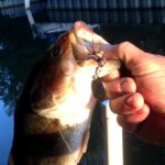
Primary Target: Crappie (Black and White)
Crappie are the undisputed kings of the spring transition in our region. Right now, both black and white crappie are staging aggressively. Depending on the specific cove and sun exposure, you will find them either in the late stages of their pre-spawn feed or actively moving up to the spawning beds. They are schooling tightly, meaning if you catch one, you are likely sitting on a dozen more. The size quality at Prairie Creek is excellent right now, with plenty of slab-sized fish pushing past the ten-inch mark.
From the editor
Tired of fishing with strangers you can’t trust?
Nautrek is the first social network for serious anglers — verified partners, real trips, cost splitting and intel sharing without burning your spots. Private beta now open.
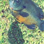
While everyone is chasing crappie and largemouth bass, the sheer volume of yellow bass in Prairie Creek Reservoir goes largely ignored by the weekend crowds. This is a massive mistake. Yellow bass are incredibly aggressive, travel in massive wolf packs, and provide non-stop action. They are the perfect day-saver when the primary bite gets tough, and they offer a fantastic opportunity for anglers bringing kids or those looking to fill a cooler quickly.
Baitfish Report
The forage base is currently dominated by early-season insect hatches and young threadfin shad. We are seeing significant midge activity near the surface during calm evenings. The baitfish are holding tight to cover, trying to avoid the predatory gauntlet. Matching this small profile is critical right now. Leave the oversized hardware in your tackle box for the summer months and focus on finesse presentations.
Tactical Strategy
Where to Target
To find the most active crappie, you need to dissect the northern coves of Prairie Creek Reservoir. These areas receive the most direct sunlight, warming the water a few degrees faster than the main basin. Focus your efforts on submerged brush piles and laydowns adjacent to 8 to 12-foot drop-offs. The fish are suspending about 4 to 8 feet down in the water column. If you are targeting the sailboat club area, look for the 10 to 19-foot humps; these are prime staging grounds for both transitioning crappie and early-season walleye.
Pro Tip: Do not waste time fishing dead water. If you do not get a bite within fifteen minutes of thoroughly probing a brush pile, pull your trolling motor and move to the next piece of structure. Spring crappie are not shy; if they are there, they will let you know.
Lure and Color Selection
Precision is everything during this seasonal transition. For artificial presentations, I highly recommend a 1/32 ounce Lindy Little Nipper Feather Jig or a 1/16 ounce Crappie Magnet Double Cross Jig. The feather jigs offer a subtle, pulsating action that triggers strikes even from lethargic fish. Given the slight stain in the water from recent runoffs, contrast is your best friend. Opt for Chartreuse/Glow patterns or a Red body with Chartreuse tails to maximize visibility.
If you are casting for largemouth bass pushing into the shallows, a 1/2 ounce Booyah Covert Series spinnerbait in White/Chartreuse with a single Colorado blade provides the perfect thump to draw reaction strikes in murky water. Work this slowly over submerged weed lines and near boat docks.
Bait Recommendations
For the live bait purists, nothing beats a lively fathead minnow fished under a slip bobber. Rig your minnows on a light wire Aberdeen hook, specifically a size 4 or 6. Hook the minnow lightly through the lips rather than the back; this allows it to swim more naturally and struggle against the hook, sending out distress vibrations that predatory fish cannot resist.
Pro Tip: Adjust your slip bobber stop so your minnow is hovering exactly six inches to one foot above the submerged brush. Crappie feed upward; if your bait is below them, they will never see it, and you will end up snagging the brush pile.
Essential Gear Checklist
To maximize your success on the water this week, ensure you have the following gear rigged and ready:
Light or ultralight action spinning rod (6'6" to 7' length) for maximum sensitivity
4 to 6-pound fluorocarbon line to reduce visibility in clearing water
Polarized sunglasses to spot submerged structure and cruising fish
A long-handled landing net to secure paper-mouthed crappie without tearing the hook out
Timing the Bite
The absolute best bite windows are occurring during the first two hours of daylight and the last hour before dusk. However, if you have an overcast day with a light chop on the water, that low-light feeding window can extend well into the afternoon. Pay attention to the moon phase as well; as we approach the full moon, midday bites often slow down, making the dawn patrol even more critical for filling your livewell.
Regulations Snapshot
Before you launch, ensure you are compliant with current Indiana Department of Natural Resources regulations for our local reservoirs. Here is the quick breakdown for your primary targets at Prairie Creek Reservoir:
Species
Minimum Size Limit
Daily Bag Limit
Season Status
Largemouth Bass
14 inches
5 fish
Open Year-Round
Crappie (Black & White)
No size limit
25 fish
Open Year-Round
Yellow Bass
No size limit
No limit
Open Year-Round
Channel Catfish
No minimum (only 1 over 28 inches)
10 fish
Open Year-Round
Regional Alternative: Mississinewa River
If the wind is howling out of the north and Prairie Creek Reservoir becomes a washing machine, do not pack it in and head home. Make the short drive north from Gaston to the Mississinewa River. This river system offers incredible protection from high winds thanks to its wooded banks and boasts a phenomenal, yet highly underrated, smallmouth bass fishery.
Access the river near the Marion stretches or any public bridge right-of-way. The water here is moving, so your tactics need to shift entirely from lake fishing. Target the current seams, rocky eddies, and the slow water directly behind large boulders or bridge pilings. Smallmouth are staging in these current breaks waiting to ambush prey as it drifts by.
Pro Tip: When fishing river current, always cast upstream and let your bait drift down naturally into the strike zone. Fish face upstream to feed, and a bait moving against the current looks unnatural and will often be ignored.
Throw a 1/8 ounce tube jig in Green Pumpkin or a small inline spinner across the current and let it swing naturally into the eddies. Keep your rod tip high to avoid snagging on the rocky bottom. The river smallmouth are pound-for-pound some of the hardest fighting fish in the region, making this backup plan feel like a primary destination.
Tight lines!
Editor's Choice: Must-Have Gear
FISHINGSIR Next-Gen Waterproof Chest Waders
★★★★★4.4 (7,370+ reviews)
2-Ply Tech: Upgraded nylon with 2.5x higher density than standard fabrics.
100% Waterproof: Lab-approved intrusion resistance with taped visible seams.
Ultra-Lightweight: Designed for all-day comfort while hunting or fishing.
As an Amazon Associate I earn from qualifying purchases. #ad
Loading forecast...
Live Fishing Conditions: Tides, Weather & Waves
Get real‑time tides, marine weather, swell and solunar activity for each spot so you know exactly when conditions line up for your best chance at a bite.
🎣
Gaston Indiana
Loading coordinates...
🌤️
WEATHER CONDITIONS
--°F
--°C
Loading...
🌡️
Feels Like--°F--°C
💧
Humidity--%
💨
Wind-- mph-- km/h
🧭
Direction--
📊
Pressure-- inHg-- hPa
☀️
UV Index--
🌊
MARINE CONDITIONS
🌊Wave Height
-- ft
-- m
Loading...
🧭Wave Direction
--°
Loading...
⏱️Wave Period
-- s
Loading...
📈Tide Status
-- ft
-- m
Loading...
🌙
LUNAR & SOLUNAR
🌕
Loading...
Illumination: --%
Major Period--:-- - --:----:-- - --:--
Minor Period--:-- - --:----:-- - --:--
🌅Sunrise--:--
🌇Sunset--:--
📅
24-HOUR FORECAST
Loading fishing conditions...
Fishing Spots Map
🎣
Book a Fishing Charter near Gaston Indiana Fishing Report Today 🎣
Local guides & charters. Verified captains, instant booking, best price guaranteed.
There was an error loading the map. Please try refreshing the page.
Info
Local Access & Facilities
Gaston, Indiana: Rural Heartland Angling
Situated in the quiet agricultural expanse of Delaware County, the fisheries surrounding Gaston, Indiana, offer a distinct change of pace from the high-pressure reservoirs of the American South or the Great Lakes to the north. This is quintessential heartland fishing, characterized by a matrix of rural creeks, accessible shorelines, and hidden gems that require a keen eye for topography. For the expert angler, the appeal here isn't just the water itself, but the tactical approach required to dissect these smaller, often overlooked systems.
The atmosphere in Gaston is defined by its working-class, agrarian roots. The horizon is lined with cornfields rather than condos, and the fishing pressure is generally localized. Unlike manicured urban harbors, the access points here are often rugged, unmarked, or integrated into the natural landscape. The vibe is low-key and traditional, where a johnboat or a pair of waders is often more valuable than a center console. This is an environment where stealth and precision casting pay dividends, particularly for those targeting the region's resident bass and panfish populations.
While the surface area of available water may seem modest compared to major impoundments, the complexity lies in the details. Seasoned captains and local pros know that the waterways near Gaston—often tributaries or small calm-water pockets—hold surprising potential for those willing to do their homework. The primary targets here include Largemouth Bass, Smallmouth Bass in the moving water sections, and robust populations of Crappie and Bluegill. The fishery rewards those who understand seasonal transitions in the Midwest, from the pre-spawn aggressive feeds to the lethargic heat of mid-July.
Access & Getting There
Reaching the fishing grounds around Gaston requires navigating a network of county roads and state highways. The primary artery for the region is Indiana State Road 28 or I-69 depending on your approach, but the final miles are almost exclusively on two-lane rural blacktop. Traffic congestion is rarely an issue in the traditional sense, but expert anglers should be mindful of agricultural machinery. During planting and harvest seasons, slow-moving combines and tractors can add significant time to the commute. Plan your route to avoid getting stuck behind heavy equipment, especially during the prime morning bite windows.
Launch realities in this part of Indiana are a mixed bag and demand a high degree of trailer competence. The data indicates boat ramps are located approximately 5 to 13 miles from the town center. These are not typically multi-lane concrete super-ramps with courtesy docks. Expect single-lane, potentially gravel or unimproved ramps that can be slick. A four-wheel-drive vehicle is highly recommended, especially after spring rains when the transition from ramp to water can become soft mud. Backing a trailer here requires precision, as turnaround spaces are often tight and bordered by drainage ditches or dense vegetation.
💡 Captain's Tip: Trailer Security
Many local access points are secluded. While crime is generally low, leave your vehicle cab empty of visible valuables. Use a high-quality coupler lock on your trailer when you are out on the water, as these remote spots offer cover for opportunistic theft.
Shore access is a significant component of the Gaston fishery. The data highlights specific coordinates for shore entries suitable for families and serious bank anglers alike. However, "suitable" does not always mean "easy." The terrain can be uneven, and vegetation along the banks is often thick during the summer months. Anglers should be prepared for a hike. Pack light and mobile; a backpack system is superior to a tackle box here. The specific coordinates provided in the map widgets below pinpoint the most viable entry zones where the gradient allows for safe approach to the water's edge.
Parking is a logistical puzzle in rural fisheries. Unlike the massive lots at state reservoirs, parking at these local spots is often limited to roadside pull-offs or small gravel patches. The nearest major paved parking structures are located over 9 miles away in Muncie (such as the P7 lot or IU Health Ball Memorial Hospital garage), which are impractical for immediate water access. Therefore, your parking strategy must be precise: arrive early to claim the few viable spots near the water. If towing, ensure your rig is pulled far enough off the shoulder to allow safe passage for wide farm equipment.
Gaston Indiana Pre-Trip Checklist
Facilities & Amenities
Infrastructure in Gaston is sparse, meaning the serious angler must be self-reliant. There are no large-scale marinas or fuel docks on the water. Fuel management is critical; top off your tanks in Muncie or along the major highways before navigating the backroads to the launch sites. The local amenities are high quality but geographically dispersed, requiring you to plan your logistics before leaving the driveway.
For tackle and live bait, the primary resource is JBC Outfitters, located approximately 9.5 miles south in Muncie. This shop has a solid reputation (4.8 rating) and is a crucial hub for local intelligence. However, their operating hours are a critical logistical detail for the dawn patrol angler. They open at 10:00 AM on weekdays and Saturdays. If you plan to hit the water at first light, you cannot rely on a morning stop here. You must secure your bait and terminal tackle the day before. They stock the specific lures that work in these waters, so a visit is valuable, just not during the pre-dawn rush.
💡 Captain's Tip: The "Night Before" Rule
Since JBC Outfitters opens at 10:00 AM, you must buy your minnows, wax worms, or nightcrawlers the evening prior. Keep them aerated and cool overnight. Showing up at the ramp at 6:00 AM without bait because you expected an early-open shop will ruin your trip.
When it comes to guides, the region is serviced by specialists like Indy Fly Guide Service, based roughly 19.8 miles away in Anderson. The presence of a dedicated fly guide service with a perfect 5-star rating indicates a sophisticated fishery, likely focusing on Smallmouth Bass and Carp on the fly in nearby moving waters. These guides are the gatekeepers of local knowledge regarding water levels and clarity, which can fluctuate rapidly in this agricultural watershed. Booking a trip with them is the fastest way to download years of pattern recognition.
Accommodation options vary from rustic to standard. For those looking to stay close to the action and embrace the outdoor experience, Mounds State Park Family Campgrounds (15.7 miles away) offers a reliable base camp with a 4.6 rating. For a more specialized stay, Victory Acres Farm in Upland (11.2 miles) and Woodland Family Camp (6.7 miles) provide lodging that aligns with the rural atmosphere. Klearwater Lake in Eaton is another nearby option that may offer its own private fishing opportunities for guests. Note that high-end hotels are situated further out in Muncie; staying locally means embracing campgrounds or small-town guest houses.
Facility Name
Type
Distance
Key Note
JBC Outfitters
Bait & Tackle
9.5 mi
Opens 10 AM (Too late for dawn patrol)
Indy Fly Guide Service
Charter/Guide
19.8 mi
Specializes in fly fishing tactics
Mounds State Park
Camping
15.7 mi
Reliable amenities and trailer space
Woodland Family Camp
Lodging
6.7 mi
Closest accommodation option
Permits, Regulations & Fees
Fishing in the Gaston area falls under the jurisdiction of the Indiana Department of Natural Resources (DNR). All anglers aged 18 and older must possess a valid Indiana fishing license. These can be purchased online or at authorized retailers, though given the late opening hours of local shops, carrying a digital copy or printing one in advance is mandatory for early starts. Conservation officers patrol these rural districts regularly, and compliance is expected.
A critical aspect of fishing in this region is the distinction between public water and private land. Much of the water in Delaware County borders private farmland. The concept of riparian rights must be strictly respected. Just because a creek crosses a road does not automatically grant access to the banks on either side of the bridge. "No Trespassing" signs are to be taken literally. In many cases, local etiquette dictates asking permission from landowners before crossing fields to reach a pond or stream section. A polite conversation can often unlock exclusive access, while trespassing will almost certainly result in the loss of access for everyone.
While the provided data indicates "No environmental alerts detected," anglers should always remain vigilant regarding water quality. Agricultural runoff can impact water conditions after heavy rains. It is prudent to check the Indiana DNR weekly fishing reports for any site-specific advisories regarding consumption, particularly for bottom-feeding species like Catfish or Carp in the larger drainage systems.
Events & Seasonal Information
The angling calendar in Gaston follows the distinct four-season rhythm of the Midwest. Spring is the marquee season, as water temperatures rise and fish move shallow to spawn. This is when the shore access points listed in the data become most productive, as bass and panfish are within casting distance of the bank. However, spring also brings high water and mud; the "unimproved" nature of local ramps means you must carefully evaluate the stability of the ground before launching.
Summer fishing settles into a pattern of early mornings and late evenings. The midday heat often shuts down the shallow bite, pushing fish into the deepest available cover or shaded creek bends. This is when the fly fishing tactics offered by Indy Fly Guide Service shine, targeting active fish in moving water that stays cooler and more oxygenated than the stagnant ponds.
💡 Captain's Tip: Wind Awareness
In this flat, agricultural topography, there are few natural windbreaks. A 15-mph wind can churn up small shallow bodies of water quickly, turning them into "chocolate milk" visibility conditions. Monitor the wind forecast closely; if it's blowing hard over the open fields, opt for protected creek sections rather than open water.
Fall offers a secondary peak in activity as fish gorge before winter. Boat traffic, already light, diminishes further, offering solitude. Winter fishing is weather-dependent; if a hard freeze occurs, ice fishing becomes viable on local ponds, but ice thickness must be tested aggressively as runoff can weaken ice sheets unexpectedly.
Contact Information & Resources
For emergencies, the primary contact is the Delaware County Sheriff's Office. Response times in rural areas can be longer than in the city, so self-reliance is paramount. Carry a comprehensive first aid kit and, if venturing into remote creek bottoms, a way to communicate that doesn't rely solely on spotty cellular data.
For specific questions regarding water levels or stocking schedules, the Indiana Department of Natural Resources District 4 fisheries biologists are the authoritative source. They can provide detailed information on which local bodies of water have received recent stockings of Catfish or Trout.
For precise locations of the boat ramps, detailed shore access coordinates, and real-time weather conditions, consult the live dashboard and interactive maps below.
Our spot reports combine data-driven forecasts with curated local information. The forecast is generated by our proprietary Fishing Score algorithm (0–100%), which analyzes real-time data from Open-Meteo API, validated against NOAA CO-OPS tide gauges and USGS water-monitoring stations. The model weights tide dynamics (35%), wave energy (25%), wind patterns (20%) and time of day (20%)—factors shown to influence fish feeding behavior through marine-biology research and decades of charter log data.
Access, facilities and services information for each fishing spot is sourced from official datasets such as Recreation.gov (RIDB), state park & wildlife agencies, and geospatial providers like Google Maps. These sections undergo scheduled re-validation every 3–6 months to ensure that boat ramps, park access, contact details and local services remain accurate.
Narrative sections (catches, seasonal behavior, local tips) are synthesized from these data sources and refined following the Fishing Reports Today editorial guidelines, combining bibliographic research from ichthyology and oceanography with expert angler experience. Our team reviews reports on a regular basis, while the forecast model itself updates every 6 hours for real-time accuracy.
⚠️ Important: Always verify current local regulations, access restrictions and weather conditions before fishing. These reports are intended as a planning aid, not a guarantee of catches or safety. When in doubt, contact local authorities or park managers listed on the page.
To provide the best experiences, we use technologies like cookies to store and/or access device information. Consenting to these technologies will allow us to process data such as browsing behavior or unique IDs on this site. Not consenting or withdrawing consent, may adversely affect certain features and functions.
Functional Always active
The technical storage or access is strictly necessary for the legitimate purpose of enabling the use of a specific service explicitly requested by the subscriber or user, or for the sole purpose of carrying out the transmission of a communication over an electronic communications network.
Preferences
The technical storage or access is necessary for the legitimate purpose of storing preferences that are not requested by the subscriber or user.
Statistics
The technical storage or access that is used exclusively for statistical purposes.The technical storage or access that is used exclusively for anonymous statistical purposes. Without a subpoena, voluntary compliance on the part of your Internet Service Provider, or additional records from a third party, information stored or retrieved for this purpose alone cannot usually be used to identify you.
Marketing & Affiliates
The technical storage or access is required to create user profiles to send advertising, or to track the user on a website or across several websites for similar marketing purposes, including affiliate tracking for products recommended in our reports.


Leave a Reply