Spring conditions on the lower Wabash River are notoriously volatile, making this a time for high vigilance. The hydrological cycle frequently brings fluctuating water levels, swift currents, and a significant amount of floating debris downstream. While the main channel is free of ice, the water temperatures are still cool enough to make hypothermia a serious risk in the event of an accident. Always wear a well-fitted, Coast Guard-approved personal flotation device.
Navigation requires extreme care during this seasonal transition. Sandbars shift dramatically over the winter months, and submerged timber that was not present last season may now be blocking familiar chutes and backwaters. Before launching at the New Harmony ramp on North Street or within Harmonie State Park, visually inspect the ramp for slick river mud left by receding waters. If the river gauge spikes from recent spring rains, consider the main river channel a no-go for smaller vessels and pivot to backwater creeks or regional alternatives.
🎣Nautrek
Private Beta
J
M
R
100+ anglers on the waitlist
The fishing network where your reputation matters.
Find trusted captains, join real trips with cost splitting, and build your Angler Rank. Your spots stay private — you decide who sees your intel.
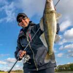
The lower Wabash River around New Harmony is a premier destination for trophy catfish. As the season progresses and water temperatures slowly rise, massive Blue Catfish—frequently found in the twenty to fifty-pound class—and highly aggressive Flathead Catfish wake from their winter lethargy. They are heavily concentrated in deep scour holes and are actively searching for high-protein meals to pack on weight prior to the spawn. Channel catfish are also abundant and provide excellent action throughout the river system.
Sleeper Pick: White Bass and Crappie
While the heavy tackle anglers focus on the main channel monsters, the feeder creeks and oxbows provide incredible light-tackle action. When the river is falling, White Bass run up the larger creeks, and Crappie stack up in the brush piles of the backwaters. Many anglers drive right past these productive zones, such as the creeks running out of Harmonie State Park, while searching for catfish in the main flow.
Baitfish Report
Gizzard shad and common carp are the most abundant and widely distributed forage species in this stretch of the river. Skipjack herring are also present and serve as a premium energy source for the apex predators. When selecting artificial lures, silver, white, and shad-profile crankbaits are highly effective. For bait anglers, perfectly matching the scent and oil profile of fresh, locally caught shad is your absolute best bet for drawing strikes from massive river cats.
3. TACTICAL STRATEGY
To maximize your success on the Wabash River, precision and adaptation to the current are critical. Boat positioning is just as important as your bait presentation.
Where: For trophy catfish, target the deep scour holes on the outside river bends, specifically downstream of the historic New Harmony bridge and near the Old Dam natural rock formations. Look for heavy submerged timber, log jams, and pronounced current seams where slow water meets fast water. Anchor securely upstream of the hole and walk your baits back into the strike zone. For White Bass and Crappie, focus on the feeder creeks entering the Wabash from the Indiana side, specifically the cuts running out of Harmonie State Park behind the island. These areas provide current breaks where panfish ambush passing bait.
Lure: When targeting the sleeper species in the creeks, cast a 1/8-ounce lead head jig paired with a three-inch white twister tail grub. For Crappie, utilize a 1/16-ounce tube jig in black and chartreuse suspended beneath a slip bobber.
Color: Water clarity in the Wabash is typically stained to muddy. Use high-visibility colors for artificials, such as chartreuse, bright white, or black-and-chartreuse combinations to create a stark silhouette in the murky water.
Bait: For the giant Blue and Flathead Catfish, fresh cut bait is non-negotiable. Harvest local gizzard shad and use large, bloody chunks. Rig these on an 8/0 to 10/0 circle hook using a Carolina rig with a three to eight-ounce no-roll sinker, depending entirely on the speed of the current.
Timing: The catfish bite reliably peaks during low-light hours, specifically at dawn, dusk, and deep into the night when these nocturnal hunters roam the shallow sand flats adjacent to deep holes. For the creek-dwelling White Bass and Crappie, the absolute best action occurs during periods of falling water levels. As the river drops, baitfish are forced out of the flooded timber and back into the defined creek channels, creating a concentrated feeding frenzy.
Pro Tip: Always monitor the USGS river gauge for New Harmony before hitching your boat trailer. The Wabash River can expand from a few hundred feet to over a mile wide in the surrounding floodplains during peak spring runoff, completely altering fish positioning, current seams, and ramp accessibility.
Pro Tip: When fishing heavy current for catfish, do not set the hook immediately when using circle hooks. Let the rod load up completely in the rod holder as the fish turns with the bait, allowing the circle hook to naturally rotate into the corner of the fish's mouth.
4. REGULATIONS SNAPSHOT
Compliance with the Indiana Department of Natural Resources regulations is critical for preserving this incredible fishery. Ensure you have your current Indiana fishing license on hand, whether a physical copy or a valid electronic version. Because the Wabash forms the border with Illinois, be acutely aware of which state's waters you are actively fishing and launching from.
Species
Minimum Size Limit
Daily Bag Limit
Special Notes
Catfish (Blue, Channel, Flathead)
No minimum size
10 per day (in aggregate)
Only one fish per day can be 28 inches or longer to protect trophy breeding stock.
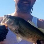
Black Bass (Largemouth, Smallmouth, Spotted)
14 inches (Rivers/Streams)
5 per day (in aggregate)
Spotted bass are common throughout this river stretch,.
Crappie (Black and White)
None on the main river
25 per day
Check local lake limits if moving to nearby impoundments.
5. REGIONAL ALTERNATIVE
If the Wabash River is blown out, heavily muddied, and choked with dangerous spring debris, do not force a risky situation on the main channel. Instead, pack up your gear and make the thirty-five to forty-minute drive south to the Hovey Lake Fish and Wildlife Area,.
Hovey Lake is a stunning 1,400-acre oxbow lake that feels more like a Louisiana bayou than the Midwest, complete with majestic bald cypress trees emerging directly from the water,. Because it is sheltered from the main river's wrath, it offers much safer and more predictable fishing conditions. Target Crappie and Largemouth Bass by pitching live minnows or weedless jigs into the intricate root systems, known as cypress knees, and submerged brush piles,. Alternatively, bank anglers and families can visit the accessible fishing ponds located right inside Harmonie State Park to target early-season bluegill and bass from the shore,.
Pro Tip: When navigating Hovey Lake, a shallow-draft vessel or kayak is highly advantageous for slipping quietly through the flooded cypress groves where the biggest bass hide.
Tight lines!
Editor's Choice: Must-Have Gear
FISHINGSIR Next-Gen Waterproof Chest Waders
★★★★★4.4 (7,370+ reviews)
2-Ply Tech: Upgraded nylon with 2.5x higher density than standard fabrics.
100% Waterproof: Lab-approved intrusion resistance with taped visible seams.
Ultra-Lightweight: Designed for all-day comfort while hunting or fishing.
As an Amazon Associate I earn from qualifying purchases. #ad
Loading forecast...
Live Fishing Conditions: Tides, Weather & Waves
Get real‑time tides, marine weather, swell and solunar activity for each spot so you know exactly when conditions line up for your best chance at a bite.
🎣
New Harmony Indiana
Loading coordinates...
🌤️
WEATHER CONDITIONS
--°F
--°C
Loading...
🌡️
Feels Like--°F--°C
💧
Humidity--%
💨
Wind-- mph-- km/h
🧭
Direction--
📊
Pressure-- inHg-- hPa
☀️
UV Index--
🌊
MARINE CONDITIONS
🌊Wave Height
-- ft
-- m
Loading...
🧭Wave Direction
--°
Loading...
⏱️Wave Period
-- s
Loading...
📈Tide Status
-- ft
-- m
Loading...
🌙
LUNAR & SOLUNAR
🌕
Loading...
Illumination: --%
Major Period--:-- - --:----:-- - --:--
Minor Period--:-- - --:----:-- - --:--
🌅Sunrise--:--
🌇Sunset--:--
📅
24-HOUR FORECAST
Loading fishing conditions...
Fishing Spots Map
🎣
Book a Fishing Charter near New Harmony Indiana Fishing Report Today 🎣
Local guides & charters. Verified captains, instant booking, best price guaranteed.
There was an error loading the map. Please try refreshing the page.
Info
Local Access & Facilities
New Harmony, Indiana, offers a distinct angling experience defined by the rhythms of the Wabash River and its proximity to the mighty Ohio River system. For the seasoned angler, this location serves less as a bustling commercial port and more as a strategic, historic launchpad for riparian solitude. The atmosphere here is quieter than the industrial hubs further south; it is a place where the morning mist over the river bottoms signals the start of the day, rather than the roar of heavy marina traffic.
The primary draw here involves navigating the intricate river bends and backwaters that define the Illinois-Indiana border. While casual fishermen may stick to the banks, expert captains utilize this location to target heavy river catfish and bass thriving in the structure-rich currents. The topography is dominated by river banks that fluctuate significantly with seasonal rainfall, requiring a keen eye for water levels and debris fields.
Understanding the logistical layout is critical for maximizing time on the water. While the town itself radiates a utopian history, the fishing reality is gritty and river-focused. You are situated near the confluence of major waterways, meaning conditions can shift rapidly from placid flows to dangerous, debris-laden currents. Success here depends on mobility and the ability to launch effectively relative to the river stage.
Access & Getting There
Reaching New Harmony is generally a straightforward drive through Posey County, but the final approach to the water requires specific local knowledge. The primary arteries are typically clear, but rural routes can become bottlenecked during harvest seasons with agricultural traffic. For those trailering heavy rigs, be mindful that the roads narrow as you approach the riverfront access points.
The launch situation is decentralized. Data indicates a boat ramp located approximately 1,985 feet from the town center, likely serving as the primary local access for the Wabash. However, for those targeting the Ohio River main stem, the John T. Myers Lock and Dam offers a robust federal access point roughly 25 miles downstream. The local ramps in New Harmony can be slick with river mud, particularly after the spring thaw or heavy rains. Traction is paramount here; experienced locals know to check the ramp condition on foot before backing down a heavy trailer.
💡 Captain's Tip: River Stage Awareness
The Wabash River fluctuates dramatically. A ramp that is perfectly usable one week may be submerged or landlocked by mud flats the next. Always check the USGS river gauge data for New Harmony before hitching the boat.
Weather contingencies are a major factor in launch decisions. The river valley can channel wind, creating chop that makes launching difficult at exposed ramps. When the winds howl from the north, the river can become treacherous for smaller craft. In these conditions, utilizing the sheltered, albeit further, access points at Harmonie State Park or the Lock and Dam facility may provide safer lee shores for launching and recovery.
Parking strategy varies by access point. In town, parking is available but limited for long trailers. The Black River Welcome Center, located about 6.1 miles away, offers a reliable staging area with a 5-star rating, though it is not a direct launch site. For secure overnight storage or overflow parking, National Storage is located 17.5 miles away in Mount Vernon. Secure your vehicle and ensure nothing valuable is left visible in the truck bed, standard practice for remote river access.
New Harmony Indiana Pre-Trip Checklist
Facilities & Amenities
Infrastructure in New Harmony is geared more towards tourism than heavy industrial fishing, so self-reliance is key. You will not find a sprawling marina complex with a fuel dock and mechanic on standby. Fueling the vessel must happen at highway stations before reaching the ramp. The local amenities are high quality but specialized, requiring anglers to plan their provisioning stops carefully.
For bait and tackle, the standout option for the "dawn patrol" crowd is Blackout Bait and Tackle. Located 6.9 miles away in Crossville, IL, they open at 7:00 AM, making them the most viable option for morning supplies. In contrast, Six H Outfitters, located 19.4 miles away, opens at 10:00 AM. This makes Six H a better stop for mid-day restocking rather than the initial morning run. Pros know to call ahead to Blackout to check their stock of live bait, as river conditions often dictate the availability of specific forage.
💡 Captain's Tip: Provisioning Logistics
There are no fuel docks on this stretch of the river. Top off your tanks and reserve jerry cans at the gas stations on the highway before entering the town limits. Running out of fuel against a river current is a safety hazard, not just an inconvenience.
Lodging options cater well to visiting anglers. For those seeking comfort after a long day on the water, the Ludwig Epple Guest House and Leather Leaf Inn Bed & Breakfast are located directly in town, mere hundreds of feet from the center. However, for the serious expedition angler, Harmonie State Park Campground (4.7 miles away) allows you to stay closer to the elements and keep your rig accessible. The campground is highly rated and provides a better setup for early departures compared to the quiet residential streets of the B&Bs.
Facility Name
Type
Distance
Key Note
Blackout Bait and Tackle
Bait Shop
6.9 miles
Opens 7:00 AM; Best for early starts.
Six H Outfitters
Bait/Gear
19.4 miles
Opens 10:00 AM; Mid-day resupply.
Harmonie State Park
Camping
4.7 miles
Trailer-friendly accommodation.
John T. Myers Lock & Dam
Access/Rec
25 miles
Heavy duty access; Federal facility.
Permits, Regulations & Fees
Navigating the regulatory landscape here requires attention to jurisdiction. The Wabash River forms the boundary between Indiana and Illinois. While reciprocal agreements often exist on border waters, expert anglers must carry valid fishing licenses for the specific state waters they intend to fish, especially if venturing into the backwaters or tributaries which may not be covered by border agreements.
The John T. Myers Lock and Dam area is managed by the U.S. Army Corps of Engineers. This is a federal facility, and security zones are strictly enforced. Fishing near the locks requires maintaining a safe distance from commercial barge traffic and respecting the restricted zones immediately above and below the dam. These rules are in place for safety due to the turbulent water and massive undertows created by the structure.
Accessing the river via Harmonie State Park will likely incur a gate fee or require a state park entrance pass. These fees support the maintenance of the ramps and grounds. Culturally, this area has deep historical roots; anglers should respect private property lines along the riverbanks. The "high water mark" generally dictates public access, but trespassing on adjacent farmland to reach a honey hole is a quick way to lose access privileges for everyone.
Events & Seasonal Information
The fishing calendar in New Harmony is dictated by the hydrological cycle of the Midwest. Spring brings high water and swift currents, often pushing debris downriver. This is a challenging time for navigation but can be productive for catfish in the inundated floodplains. As summer stabilizes the flow, the river becomes more predictable, though the heat can drive fish into deeper holes during the midday sun.
While specific tournament schedules fluctuate, the region sees activity during the warmer months when the river levels are manageable. The most consistent fishing window is early morning, particularly during the summer when the humidity builds rapidly by noon. The trade-off for the summer stability is recreational boat traffic, though it is generally lighter here than on the main recreational pools of the Ohio River.
💡 Captain's Tip: Lock Schedules
If you plan to lock through at the John T. Myers facility to access different pools, be aware that commercial traffic always has priority. Recreational craft can wait hours for a lockage. Monitor VHF channels for barge communication to anticipate delays.
Contact Information & Resources
For official information regarding river conditions and federal access, the John T. Myers Lock and Dam can be reached at (812) 838-5836. They can provide the most accurate data on water release schedules and lock operations. For camping and local park access questions, Harmonie State Park is the primary resource at (812) 682-4821.
Safety on the river is the skipper's responsibility. Cell service can be spotty in the river bottoms. Always file a float plan and ensure your safety gear is rated for the strong currents typical of the Wabash and Ohio rivers. Self-reliance is the rule of the water here.
For precise locations, real-time weather data, and detailed facility maps, consult the live dashboard and interactive widgets below.
Our spot reports combine data-driven forecasts with curated local information. The forecast is generated by our proprietary Fishing Score algorithm (0–100%), which analyzes real-time data from Open-Meteo API, validated against NOAA CO-OPS tide gauges and USGS water-monitoring stations. The model weights tide dynamics (35%), wave energy (25%), wind patterns (20%) and time of day (20%)—factors shown to influence fish feeding behavior through marine-biology research and decades of charter log data.
Access, facilities and services information for each fishing spot is sourced from official datasets such as Recreation.gov (RIDB), state park & wildlife agencies, and geospatial providers like Google Maps. These sections undergo scheduled re-validation every 3–6 months to ensure that boat ramps, park access, contact details and local services remain accurate.
Narrative sections (catches, seasonal behavior, local tips) are synthesized from these data sources and refined following the Fishing Reports Today editorial guidelines, combining bibliographic research from ichthyology and oceanography with expert angler experience. Our team reviews reports on a regular basis, while the forecast model itself updates every 6 hours for real-time accuracy.
⚠️ Important: Always verify current local regulations, access restrictions and weather conditions before fishing. These reports are intended as a planning aid, not a guarantee of catches or safety. When in doubt, contact local authorities or park managers listed on the page.
To provide the best experiences, we use technologies like cookies to store and/or access device information. Consenting to these technologies will allow us to process data such as browsing behavior or unique IDs on this site. Not consenting or withdrawing consent, may adversely affect certain features and functions.
Functional Always active
The technical storage or access is strictly necessary for the legitimate purpose of enabling the use of a specific service explicitly requested by the subscriber or user, or for the sole purpose of carrying out the transmission of a communication over an electronic communications network.
Preferences
The technical storage or access is necessary for the legitimate purpose of storing preferences that are not requested by the subscriber or user.
Statistics
The technical storage or access that is used exclusively for statistical purposes.The technical storage or access that is used exclusively for anonymous statistical purposes. Without a subpoena, voluntary compliance on the part of your Internet Service Provider, or additional records from a third party, information stored or retrieved for this purpose alone cannot usually be used to identify you.
Marketing & Affiliates
The technical storage or access is required to create user profiles to send advertising, or to track the user on a website or across several websites for similar marketing purposes, including affiliate tracking for products recommended in our reports.


Leave a Reply