
An Oasis in the Hieroglyphic Mountains
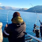
Lake Pleasant serves as the crown jewel of water recreation for the North Phoenix valley, offering a stark, beautiful contrast between the arid Sonoran Desert landscape and deep, cool waters. Fed by the Central Arizona Project and held back by the massive New Waddell Dam, this reservoir is far more than a simple storage tank; it is a dynamic, 10,000-acre fishery that demands respect and strategy from serious anglers. The lake is framed by the rugged Hieroglyphic Mountains, creating a backdrop of red dirt and black lava rock that glows intensely during the dawn patrol hours favored by local pros.
For the seasoned captain, Lake Pleasant represents a unique challenge of depth and structure. Unlike the shallower, weed-choked ponds found elsewhere in the state, this is a deep-water canyon reservoir. The topography is steep, plunging rapidly from the rocky shorelines into significant depths where striped bass schools roam. The water here is typically clear, requiring light fluorocarbon leaders and finesse presentations, particularly when targeting the lake's pressured largemouth and white bass populations. The "vibe" here shifts dramatically from a quiet, tactical fishery at sunrise to a high-energy recreational hub by noon, making timing the most critical element of a successful trip.
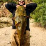
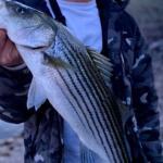
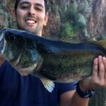
The primary draw for sportfishing fleets here involves the "big three": Striped Bass, Largemouth Bass, and White Bass. While Channel Catfish and Black Crappie also inhabit these waters, the adrenaline of chasing boiling stripers or working the submerged structural elements for a double-digit largemouth is what brings the dedicated boats up Interstate 17. With 114 miles of shoreline to explore, there is ample room to escape the pressure, provided you have the navigation skills to work the northern arms of the lake.
Access & Getting There
Reaching Lake Pleasant requires a straightforward but strategic approach, especially for those towing heavy fiberglass. The primary artery for access is State Route 74, locally known as the Carefree Highway. Most anglers coming from the Phoenix metro area will shoot north on Interstate 17 before cutting west on SR-74. From there, the turn onto Castle Hot Springs Road leads you directly into the heart of the park's main access points. While the highways are generally wide and trailer-friendly, traffic on I-17 can be a bottleneck on Friday afternoons and Sunday evenings.
💡 Captain's Tip: The "Dawn Patrol" Commute
Traffic on the Carefree Highway can be deceptively fast. However, seasoned locals know that boat traffic lines up at the entry station well before sunrise on weekends. To maximize your time with lines in the water, aim to clear the entry gate by 5:00 AM during the summer months.
The launch infrastructure at Lake Pleasant is among the best in the Southwest, specifically designed to handle high-volume recreational traffic. The reservoir boasts a massive 10-lane boat ramp located on the western shore. This is not a cramped, single-lane ordeal; it is a wide, well-maintained concrete expanse that allows for efficient multiple-vessel launching. However, the sheer size of the ramp can lead to chaotic scenes during peak hours. Solo skippers should be particularly cautious of novice boaters who may struggle with trailer maneuvering on the wide apron. The ramp angle is generally consistent, but during extreme low water levels—common in Western reservoirs—the end of the concrete can become slick with algae.
Parking is abundant but not infinite. The facility provides designated parking for approximately 200 vehicles with trailers. While this sounds substantial, the lot fills rapidly during the spring striper run and summer weekends. Overflow parking is available, but it often involves a significant hike back to the ramp, which is less than ideal after a long day in the desert heat. Security is generally good within the park boundaries, with regular patrols by Maricopa County staff, but standard precautions regarding gear left in truck beds should always be observed.
Weather is the single biggest variable dictating access on Lake Pleasant. Because the lake sits in a canyon depression surrounded by the Hieroglyphic Mountains, it acts as a wind tunnel. When the afternoon thermals kick up, usually around 11:00 AM, the central basin can transform from glass to whitecaps in minutes. The 10-lane ramp is somewhat exposed to the prevailing fetch. If the wind is howling out of the west or southwest, retrieving a boat can become a white-knuckle experience. Experienced captains will often opt to launch and retrieve early to avoid the afternoon "washing machine" conditions.
Lake Pleasant, Phoenix Pre-Trip Checklist
Facilities & Amenities
The infrastructure at Lake Pleasant is bifurcated: excellent on-water facilities and camping, but a notable lack of specialized tackle retail immediately adjacent to the water. The Pleasant Harbor Marina is a full-service operation capable of handling 1,000 boats, offering fuel and basic supplies. However, for specialized angling needs, you are largely on your own once you pass the park gate. This is a "bring what you need" fishery.
One critical piece of "negative knowledge" for the traveling angler is the distance to quality bait and tackle shops. There are no high-end pro shops located directly on the shoreline. The closest reliable outfitter, Basstackle LLC, is located approximately 15.6 miles away in Phoenix. Similarly, The Stock Shop is roughly 16.8 miles from the water. If you break a rod tip or run out of live bait, it is a minimum 40-minute round trip to rectify the situation. You must verify your gear manifest before leaving the pavement of the city.
💡 Captain's Tip: Fuel Logistics
While there is a marina with fuel pumps, prices on the water are significantly higher than on land. The smart play is to top off your vessel and tow vehicle at the stations along Carefree Highway before entering the park limits.
For multi-day excursions, the lodging options are tailored toward the RV and camping crowd rather than hotel dwellers. The Roadrunner Campground and Desert Tortoise Campground are located directly within the park, offering immediate access to the water. These are not primitive gravel patches; many sites offer hookups and paved pads. For those seeking luxury, the JW Marriott Phoenix Desert Ridge Resort & Spa is the nearest high-end hotel, but it sits over 20 miles away, making it a poor choice for those targeting a first-light bite. The table below outlines key facilities for planning your logistics.
| Facility Name | Type | Distance from Water | Key Features |
|---|---|---|---|
| Basstackle LLC | Tackle Shop | 15.6 miles | Specialized bass gear, open 8 AM - 3 PM. |
| Roadrunner Campground | Lodging | On-Site (0.4 miles) | Paved sites, close to ramp, 4.6-star rating. |
| Desert Tortoise Campground | Lodging | On-Site (1.9 miles) | Camping, park managed, scenic views. |
| Pleasant Harbor Marina | Marina | On-Site | Fuel, 1,000 slips, general supplies. |
| No-Limit-Fishing | Charter | 2.5 miles | Local guide service, 24-hour availability listed. |
A unique feature of the area surrounding Lake Pleasant is the presence of several recreational shooting sites managed by the Bureau of Land Management (BLM). Sites like Saddleback Mountain and Baldy Mountain are located within a few miles of the lake. It is crucial for anglers to understand that these are designated areas for long-range rifle shooting. The noise from these ranges can sometimes be heard from the western arms of the lake, but they do not interfere with water access. Note that these ranges strictly prohibit shotguns and pistols; they are for precision rifle use only.
Permits, Regulations & Fees
Navigating the bureaucracy of Lake Pleasant is relatively simple, but compliance is strictly enforced. The lake falls under the jurisdiction of Maricopa County Parks & Recreation, while the fishery itself is managed by the Arizona Game and Fish Department. This means you are dealing with two separate fee structures: one for entering the park and launching your boat, and another for the privilege of fishing.
A valid Arizona state fishing license is mandatory for any angler 10 years of age or older. These can be purchased online or at the distant tackle shops mentioned earlier, but they are generally not sold at the park entry gate. Do not tow your boat all the way to the ramp assuming you can buy a license at the kiosk. The park entry fee is per vehicle and per watercraft. These fees contribute to the maintenance of the high-quality ramps and the clean restrooms found at the Ringtail Day Use Area and other access points.
💡 Captain's Tip: The Two-Pass System
Remember that your "Annual Park Pass" for Maricopa County covers entry, but often does not cover the boat launch fee. Ensure you have the specific "Watercraft" add-on or be prepared to pay the daily launch fee at the automated kiosks.
Conservation and cultural respect are paramount here. The area borders the Hell's Canyon Wilderness, a 9,951-acre protected area in the Hieroglyphic Mountains. While motorized vehicles are prohibited within the wilderness boundaries, the shoreline adjacent to these areas is sensitive. Anglers pushing deep into the creek arms should be mindful of "Kapu" or respectful behavior regarding the land. The mix of federal BLM land, county park land, and state waters creates a patchwork of regulations, but the rule of thumb is simple: Leave No Trace. The desert ecosystem is fragile; trash left on the red dirt shoreline stays there for decades.
Events & Seasonal Information
Lake Pleasant operates on a distinct seasonal rhythm driven by the extreme Arizona climate. The "high season" for human activity is summer, but for serious anglers, the heat dictates a nocturnal schedule. From June through September, the best fishing occurs under the lights. This is when the striper boil activity is at its peak, often occurring in the coolest part of the night or the very first grey light of dawn. During these months, recreational boat traffic (wakeboarders and jet skis) makes daytime fishing on the main lake nearly impossible.
Winter changes the dynamic entirely. The jet skis disappear, and the lake becomes the domain of the serious bass angler. The water cools, and the largemouth bass move to deeper structure. This is tournament season. Local clubs and regional circuits frequently utilize the 10-lane ramp for weigh-ins. If you are planning a trip between November and March, check the tournament schedules. A 100-boat tournament launch at 6:00 AM can clog the facility for an hour, delaying your recreational launch.
The transition periods—Spring and Fall—offer the best balance. The Billfish mentioned in ocean contexts obviously don't apply here, but the "Striped Bass run" in the spring mimics a saltwater blitz. Schools of white bass and stripers push shad into the coves, creating frantic surface action that can be seen from hundreds of yards away. This is the time to have topwater lures tied on and ready.
Contact Information & Resources
For the most current information on water levels, ramp closures, or fire restrictions, direct communication with the managing agencies is recommended. Maricopa County Parks & Recreation can be reached at 602-372-7460 or via email at lakepleasant@mail.maricopa.gov. They maintain the physical facilities and are the best source for questions regarding camping availability or ramp status.
For emergencies on the water, standard maritime VHF channels are monitored, but cell service is generally reliable on the main body of the lake. In immediate danger, dial 911. For non-emergency wildlife issues or regulatory questions, the Arizona Game and Fish Department is the authority. Self-reliance is key; always carry ample water and sun protection, as the desert sun is unforgiving even in winter.
For precise locations of the boat ramps, the specific coordinates of the deep-water marinas, and real-time weather conditions affecting the reservoir, consult the live dashboard and interactive maps below.


Leave a Reply