
Gaston, Indiana: Rural Heartland Angling
Situated in the quiet agricultural expanse of Delaware County, the fisheries surrounding Gaston, Indiana, offer a distinct change of pace from the high-pressure reservoirs of the American South or the Great Lakes to the north. This is quintessential heartland fishing, characterized by a matrix of rural creeks, accessible shorelines, and hidden gems that require a keen eye for topography. For the expert angler, the appeal here isn't just the water itself, but the tactical approach required to dissect these smaller, often overlooked systems.
The atmosphere in Gaston is defined by its working-class, agrarian roots. The horizon is lined with cornfields rather than condos, and the fishing pressure is generally localized. Unlike manicured urban harbors, the access points here are often rugged, unmarked, or integrated into the natural landscape. The vibe is low-key and traditional, where a johnboat or a pair of waders is often more valuable than a center console. This is an environment where stealth and precision casting pay dividends, particularly for those targeting the region's resident bass and panfish populations.
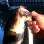
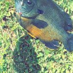
While the surface area of available water may seem modest compared to major impoundments, the complexity lies in the details. Seasoned captains and local pros know that the waterways near Gaston—often tributaries or small calm-water pockets—hold surprising potential for those willing to do their homework. The primary targets here include Largemouth Bass, Smallmouth Bass in the moving water sections, and robust populations of Crappie and Bluegill. The fishery rewards those who understand seasonal transitions in the Midwest, from the pre-spawn aggressive feeds to the lethargic heat of mid-July.
Access & Getting There
Reaching the fishing grounds around Gaston requires navigating a network of county roads and state highways. The primary artery for the region is Indiana State Road 28 or I-69 depending on your approach, but the final miles are almost exclusively on two-lane rural blacktop. Traffic congestion is rarely an issue in the traditional sense, but expert anglers should be mindful of agricultural machinery. During planting and harvest seasons, slow-moving combines and tractors can add significant time to the commute. Plan your route to avoid getting stuck behind heavy equipment, especially during the prime morning bite windows.
Launch realities in this part of Indiana are a mixed bag and demand a high degree of trailer competence. The data indicates boat ramps are located approximately 5 to 13 miles from the town center. These are not typically multi-lane concrete super-ramps with courtesy docks. Expect single-lane, potentially gravel or unimproved ramps that can be slick. A four-wheel-drive vehicle is highly recommended, especially after spring rains when the transition from ramp to water can become soft mud. Backing a trailer here requires precision, as turnaround spaces are often tight and bordered by drainage ditches or dense vegetation.
💡 Captain's Tip: Trailer Security
Many local access points are secluded. While crime is generally low, leave your vehicle cab empty of visible valuables. Use a high-quality coupler lock on your trailer when you are out on the water, as these remote spots offer cover for opportunistic theft.
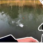
Shore access is a significant component of the Gaston fishery. The data highlights specific coordinates for shore entries suitable for families and serious bank anglers alike. However, "suitable" does not always mean "easy." The terrain can be uneven, and vegetation along the banks is often thick during the summer months. Anglers should be prepared for a hike. Pack light and mobile; a backpack system is superior to a tackle box here. The specific coordinates provided in the map widgets below pinpoint the most viable entry zones where the gradient allows for safe approach to the water's edge.
Parking is a logistical puzzle in rural fisheries. Unlike the massive lots at state reservoirs, parking at these local spots is often limited to roadside pull-offs or small gravel patches. The nearest major paved parking structures are located over 9 miles away in Muncie (such as the P7 lot or IU Health Ball Memorial Hospital garage), which are impractical for immediate water access. Therefore, your parking strategy must be precise: arrive early to claim the few viable spots near the water. If towing, ensure your rig is pulled far enough off the shoulder to allow safe passage for wide farm equipment.
Gaston Indiana Pre-Trip Checklist
Facilities & Amenities
Infrastructure in Gaston is sparse, meaning the serious angler must be self-reliant. There are no large-scale marinas or fuel docks on the water. Fuel management is critical; top off your tanks in Muncie or along the major highways before navigating the backroads to the launch sites. The local amenities are high quality but geographically dispersed, requiring you to plan your logistics before leaving the driveway.
For tackle and live bait, the primary resource is JBC Outfitters, located approximately 9.5 miles south in Muncie. This shop has a solid reputation (4.8 rating) and is a crucial hub for local intelligence. However, their operating hours are a critical logistical detail for the dawn patrol angler. They open at 10:00 AM on weekdays and Saturdays. If you plan to hit the water at first light, you cannot rely on a morning stop here. You must secure your bait and terminal tackle the day before. They stock the specific lures that work in these waters, so a visit is valuable, just not during the pre-dawn rush.
💡 Captain's Tip: The "Night Before" Rule
Since JBC Outfitters opens at 10:00 AM, you must buy your minnows, wax worms, or nightcrawlers the evening prior. Keep them aerated and cool overnight. Showing up at the ramp at 6:00 AM without bait because you expected an early-open shop will ruin your trip.
When it comes to guides, the region is serviced by specialists like Indy Fly Guide Service, based roughly 19.8 miles away in Anderson. The presence of a dedicated fly guide service with a perfect 5-star rating indicates a sophisticated fishery, likely focusing on Smallmouth Bass and Carp on the fly in nearby moving waters. These guides are the gatekeepers of local knowledge regarding water levels and clarity, which can fluctuate rapidly in this agricultural watershed. Booking a trip with them is the fastest way to download years of pattern recognition.
Accommodation options vary from rustic to standard. For those looking to stay close to the action and embrace the outdoor experience, Mounds State Park Family Campgrounds (15.7 miles away) offers a reliable base camp with a 4.6 rating. For a more specialized stay, Victory Acres Farm in Upland (11.2 miles) and Woodland Family Camp (6.7 miles) provide lodging that aligns with the rural atmosphere. Klearwater Lake in Eaton is another nearby option that may offer its own private fishing opportunities for guests. Note that high-end hotels are situated further out in Muncie; staying locally means embracing campgrounds or small-town guest houses.
| Facility Name | Type | Distance | Key Note |
|---|---|---|---|
| JBC Outfitters | Bait & Tackle | 9.5 mi | Opens 10 AM (Too late for dawn patrol) |
| Indy Fly Guide Service | Charter/Guide | 19.8 mi | Specializes in fly fishing tactics |
| Mounds State Park | Camping | 15.7 mi | Reliable amenities and trailer space |
| Woodland Family Camp | Lodging | 6.7 mi | Closest accommodation option |
Permits, Regulations & Fees
Fishing in the Gaston area falls under the jurisdiction of the Indiana Department of Natural Resources (DNR). All anglers aged 18 and older must possess a valid Indiana fishing license. These can be purchased online or at authorized retailers, though given the late opening hours of local shops, carrying a digital copy or printing one in advance is mandatory for early starts. Conservation officers patrol these rural districts regularly, and compliance is expected.
A critical aspect of fishing in this region is the distinction between public water and private land. Much of the water in Delaware County borders private farmland. The concept of riparian rights must be strictly respected. Just because a creek crosses a road does not automatically grant access to the banks on either side of the bridge. "No Trespassing" signs are to be taken literally. In many cases, local etiquette dictates asking permission from landowners before crossing fields to reach a pond or stream section. A polite conversation can often unlock exclusive access, while trespassing will almost certainly result in the loss of access for everyone.
While the provided data indicates "No environmental alerts detected," anglers should always remain vigilant regarding water quality. Agricultural runoff can impact water conditions after heavy rains. It is prudent to check the Indiana DNR weekly fishing reports for any site-specific advisories regarding consumption, particularly for bottom-feeding species like Catfish or Carp in the larger drainage systems.
Events & Seasonal Information
The angling calendar in Gaston follows the distinct four-season rhythm of the Midwest. Spring is the marquee season, as water temperatures rise and fish move shallow to spawn. This is when the shore access points listed in the data become most productive, as bass and panfish are within casting distance of the bank. However, spring also brings high water and mud; the "unimproved" nature of local ramps means you must carefully evaluate the stability of the ground before launching.
Summer fishing settles into a pattern of early mornings and late evenings. The midday heat often shuts down the shallow bite, pushing fish into the deepest available cover or shaded creek bends. This is when the fly fishing tactics offered by Indy Fly Guide Service shine, targeting active fish in moving water that stays cooler and more oxygenated than the stagnant ponds.
💡 Captain's Tip: Wind Awareness
In this flat, agricultural topography, there are few natural windbreaks. A 15-mph wind can churn up small shallow bodies of water quickly, turning them into "chocolate milk" visibility conditions. Monitor the wind forecast closely; if it's blowing hard over the open fields, opt for protected creek sections rather than open water.
Fall offers a secondary peak in activity as fish gorge before winter. Boat traffic, already light, diminishes further, offering solitude. Winter fishing is weather-dependent; if a hard freeze occurs, ice fishing becomes viable on local ponds, but ice thickness must be tested aggressively as runoff can weaken ice sheets unexpectedly.
Contact Information & Resources
For emergencies, the primary contact is the Delaware County Sheriff's Office. Response times in rural areas can be longer than in the city, so self-reliance is paramount. Carry a comprehensive first aid kit and, if venturing into remote creek bottoms, a way to communicate that doesn't rely solely on spotty cellular data.
For specific questions regarding water levels or stocking schedules, the Indiana Department of Natural Resources District 4 fisheries biologists are the authoritative source. They can provide detailed information on which local bodies of water have received recent stockings of Catfish or Trout.
For precise locations of the boat ramps, detailed shore access coordinates, and real-time weather conditions, consult the live dashboard and interactive maps below.


Leave a Reply