Current seasonal conditions at Freedom Park Pond in Burley, Idaho, are highly favorable, making this a definitive "GO" for anglers of all skill levels. The winter ice has completely receded, leaving the 0.9-acre waterbody entirely open and fishable from all banks. As we push through the early spring transition, the weather plays a crucial role in fish behavior. While the early mornings still carry a sharp, biting chill that keeps the water temperatures suppressed, the afternoon sun is highly effective at warming the shallow margins of the pond.
Safety is currently a non-issue regarding ice, but anglers should exercise mild caution regarding shoreline conditions. Spring thaws and occasional rain showers can leave the grassy banks and dirt access points slick and muddy. Waterproof boots with solid traction are highly recommended. Wind can also be a factor in the Cassia County valley; a stiff breeze will create a chop on the water, which actually helps conceal your presence from the fish, but it can make casting ultralight tackle challenging. Plan your trip with confidence, but dress in layers to adapt to the rapid temperature swings typical of an Idaho spring.
🎣Nautrek
Private Beta
J
M
R
100+ anglers on the waitlist
The fishing network where your reputation matters.
Find trusted captains, join real trips with cost splitting, and build your Angler Rank. Your spots stay private — you decide who sees your intel.
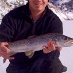
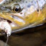
The undisputed main event at Freedom Park Pond right now is the Rainbow Trout. The Idaho Department of Fish and Game utilizes this accessible pond as a prime location for their spring stocking program, heavily planting it with catchable-sized rainbows measuring in the 10-to-12-inch class. Because this is a compact, closed system, these stocked fish are highly concentrated. They are currently exhibiting aggressive, schooling behavior. Fresh stockers are generally naive to angling pressure for the first few weeks, making them highly cooperative targets if you present the right profile.
Sleeper Pick: Greengill Hybrids
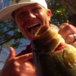
While the vast majority of anglers are hyper-focused on the freshly planted trout, the resident panfish population offers a fantastic secondary target. The pond holds a population of greengills—a robust hybrid between green sunfish and bluegill. These hybrids possess the aggressive territorial nature of the green sunfish and the broad, saucer-like profile of a bluegill. As the water column warms in the late afternoon, these panfish emerge from the deeper basin to forage along the edges, providing excellent light-tackle sport that most visitors completely ignore.
Baitfish & Forage Report
In a small 0.9-acre environment, large baitfish populations are virtually non-existent. Instead, the forage base consists heavily of macroinvertebrates. The trout and panfish are actively hunting chironomid (midge) pupae, early-season aquatic insect hatches, and terrestrial worms washed into the pond by spring runoff. However, because the primary targets are recently stocked hatchery fish, their strongest feeding instinct is still keyed to the high-protein pellets they were raised on. Lures that trigger a reactionary strike or baits that mimic the scent and profile of hatchery food will vastly outperform natural baitfish imitations right now.
Tactical Strategy
Where to Deploy
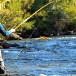
Navigating a micro-fishery like Freedom Park Pond requires a strategic approach; you cannot simply cast to the middle and hope for the best. The fish here patrol specific transition zones. Focus your efforts on the subtle drop-offs located approximately eight to twelve feet off the shoreline. Hatchery trout tend to cruise the perimeter in a uniform, circular pattern. Position yourself near the inflow or outflow areas, as these zones provide highly oxygenated water and act as a natural conveyor belt for food. If the wind is blowing, set up on the windward shore—the wind pushes the warmer surface water and floating insects against this bank, and the fish will follow.
Lure Selection & Presentation
To trigger aggressive reaction strikes, you need to appeal to the trout's lateral line and vision. Ensure your setup includes:
A 6-foot to 6.5-foot ultralight spinning rod for maximum strike sensitivity.
A 1000-size spinning reel with a smooth, reliable drag system.
4-pound test fluorocarbon line to remain invisible in clear water.
Tie on a 1/16oz to 1/8oz inline spinner; the classic Rooster Tail or a Panther Martin are exceptional choices. Alternatively, a 1/16oz marabou jig suspended two feet under a small strike indicator can be deadly when the fish are suspended mid-column.
Color Palette
Given the slight stain in the water from spring runoff and the naive nature of hatchery fish, bright, unnatural colors are your best bet. Chartreuse, fluorescent pink, and white are yielding the highest strike rates. If you are throwing metallic spoons like a Kastmaster, opt for a gold finish on overcast days to maximize contrast, and switch to silver when the sun is piercing the water column.
Bait & Rigging
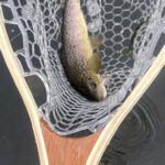
If you prefer a stationary approach, dough bait is the undisputed champion for stocked rainbows. Utilize a standard Carolina rig: thread a 1/4oz sliding egg sinker onto your main line, tie on a small barrel swivel, and attach a 12-to-18-inch leader of 4-pound fluorocarbon. Finish with a size 16 treble hook completely buried inside a dime-sized ball of floating trout dough. Garlic-scented or rainbow-colored dough baits are highly effective. The sliding sinker allows the fish to pick up the bait without feeling resistance, while the floating dough hovers perfectly in their strike zone, avoiding bottom debris.
Timing the Bite
Forget the traditional "crack of dawn" strategy. During the early spring, the water is simply too cold at sunrise, leaving the fish sluggish and glued to the bottom. The optimal feeding window currently opens around 10:30 AM and peaks between 1:00 PM and 3:00 PM. This midday period allows the sun to penetrate the water, raising the ambient temperature by a few degrees—just enough to activate the trout's metabolism and push them higher in the water column.
Pro Tip: When retrieving spinners or spoons, do not use a monotone, steady reel. Incorporate a "stop-and-go" cadence. Hatchery trout are notorious for following a lure right up to the bank without committing. A sudden, half-second pause makes the lure flutter downward, mimicking a stunned or dying prey item, which almost always triggers an aggressive reaction strike from a trailing fish.
Pro Tip: Freshly stocked trout travel in tight pods and run "laps" around small ponds. If the bite suddenly dies, resist the urge to constantly recast and move. Leave your bait in the water and practice patience; the school is likely circling the pond and will return to your exact location within 15 to 20 minutes.
Pro Tip: If the trout are proving finicky, downsize your hardware. Swap your standard snap swivels for a direct knot to the lure, and drop your fluorocarbon leader down to 2-pound test. In highly pressured, clear-water ponds, eliminating terminal tackle visibility can instantly double your hookup ratio.
Regulations Snapshot
Freedom Park Pond operates under the general Idaho family fishing water regulations, which are designed to encourage participation while maintaining the fishery.
Species
Daily Bag Limit
Size Restrictions
Rainbow Trout
6 per angler
No minimum size
Panfish (Greengill)
No limit
No minimum size
A valid Idaho state fishing license is mandatory for all anglers aged 14 and older. Youth anglers under the age of 14 may fish for free. While the regulations allow for generous harvests, we highly encourage practicing selective harvest—keep a few trout for the frying pan, but consider releasing the larger resident panfish to preserve the pond's ecological balance. Always consult the official Idaho Fish and Game seasons and rules booklet for emergency closures or localized updates before casting.
Regional Alternative
If you arrive at Freedom Park Pond and find the banks too crowded, or if severe localized winds make fishing the open water difficult, you have an exceptional backup plan just a short drive away. Pack up your gear and head toward the Hagerman Wildlife Management Area, specifically targeting Riley Creek Pond or the Oster Lakes complex.
The Hagerman WMA is a crown jewel for early-season trout anglers in the Magic Valley region. These waters are heavily subsidized by the nearby state hatcheries and receive massive, frequent stockings—often numbering in the thousands of fish per cycle. Because the WMA features multiple interconnected ponds and mature surrounding vegetation, it offers significantly better wind protection than the exposed banks of a city park. You can deploy the exact same tactical strategy here: cast flashy gold
spoons and inline spinners, or float brightly colored dough bait on a Carolina rig. The sheer volume of water and variety of structure at Hagerman means you can almost always find a secluded bank, even on busy spring weekends. Plus, the chance of tying into a holdover trophy trout from previous stocking cycles is significantly higher in the Oster Lakes complex.
Amenities & Access
Freedom Park offers excellent accessibility, making it an ideal destination for families, elderly anglers, or those with mobility challenges. Paved walkways surround a significant portion of the pond, providing stable, mud-free casting platforms when the natural banks get sloppy from spring showers. Public restrooms are available on-site, and ample parking is situated just a short walk from the water's edge. Nearby picnic tables and open grassy areas make it easy to turn a quick afternoon fishing trip into a full family outing. Be mindful of other park users, watch your backcast near the walking paths, and always remember to pack out all discarded fishing line, hooks, and bait containers to keep this urban fishery pristine for the Burley community.
Tight lines!
Editor's Choice: Must-Have Gear
FISHINGSIR Next-Gen Waterproof Chest Waders
★★★★★4.4 (7,370+ reviews)
2-Ply Tech: Upgraded nylon with 2.5x higher density than standard fabrics.
100% Waterproof: Lab-approved intrusion resistance with taped visible seams.
Ultra-Lightweight: Designed for all-day comfort while hunting or fishing.
As an Amazon Associate I earn from qualifying purchases. #ad
🐟Freedom Park Idaho
Species data is being updated for this location.
Check back soon for fishing forecasts.
Live Fishing Conditions: Tides, Weather & Waves
Get real‑time tides, marine weather, swell and solunar activity for each spot so you know exactly when conditions line up for your best chance at a bite.
🎣
Freedom Park Idaho
Loading coordinates...
🌤️
WEATHER CONDITIONS
--°F
--°C
Loading...
🌡️
Feels Like--°F--°C
💧
Humidity--%
💨
Wind-- mph-- km/h
🧭
Direction--
📊
Pressure-- inHg-- hPa
☀️
UV Index--
🌊
MARINE CONDITIONS
🌊Wave Height
-- ft
-- m
Loading...
🧭Wave Direction
--°
Loading...
⏱️Wave Period
-- s
Loading...
📈Tide Status
-- ft
-- m
Loading...
🌙
LUNAR & SOLUNAR
🌕
Loading...
Illumination: --%
Major Period--:-- - --:----:-- - --:--
Minor Period--:-- - --:----:-- - --:--
🌅Sunrise--:--
🌇Sunset--:--
📅
24-HOUR FORECAST
Loading fishing conditions...
Fishing Spots Map
🎣
Book a Fishing Charter near Freedom Park Idaho Fishing Report Today 🎣
Local guides & charters. Verified captains, instant booking, best price guaranteed.
There was an error loading the map. Please try refreshing the page.
Info
Local Access & Facilities
Situated in the heart of the Magic Valley, Freedom Park serves as a strategic gateway to the Snake River’s diverse fishery. This location offers anglers a unique blend of high-desert scenery and productive water, characterized by basalt cliffs, sagebrush plains, and deep river channels. The area is a transition zone where the river widens, creating opportunities for both power boating and technical shoreline stalking.
The atmosphere here is distinctly rugged yet accessible. While the park itself provides a manicured urban interface in Burley, the surrounding waters quickly shift into the wilder, historic landscapes of the Oregon Trail. The river bottom here is often rocky, requiring careful navigation, but the structure holds excellent populations of game fish. The prevailing high-desert climate means mornings can be crisp even in summer, and the wind is a constant variable that seasoned captains learn to use to their advantage.
For the serious angler, the primary draws here are Rainbow Trout and Largemouth Bass, with significant populations of Crappie and Yellow Perch available in the impoundments. The Snake River system here is managed heavily for irrigation, meaning water levels can fluctuate, altering holding pockets and accessibility. Understanding the interplay between the Minidoka Dam flows and the river current is the key to unlocking the bite in this section of Idaho.
Access & Getting There
Accessing Freedom Park and the surrounding Snake River fisheries is straightforward via Interstate 84. Most anglers will approach through the city of Burley. Traffic is generally light compared to major metropolitan areas, but agricultural machinery on secondary roads can slow transit times during harvest seasons. The primary launch facilities are located directly within the Burley area, with additional strategic access points upstream and downstream.
For those looking to launch larger vessels, the local ramps are generally well-maintained concrete structures. However, river levels are dictated by the Bureau of Reclamation. During late summer drawdowns, the end of the ramp may approach quickly; visual inspection before backing down is mandatory. The Milner Historic Recreation Area, located approximately 11.5 miles west, offers two boat ramps. One includes a dedicated kayak/canoe launch, ideal for those looking to fish the rocky shorelines quietly.
💡 Captain's Tip: RV Clearance Warning
If you are hauling a fifth-wheel or driving a tall recreational vehicle to the Milner Historic Recreation Area, use the West Entrance. The East Entrance has low clearance that has claimed many A/C units and rod tips. Approach with extreme caution.
Weather is the single biggest logistical challenge in this region. The open sagebrush topography offers little resistance to wind. When winds exceed 15 mph, the chop on the wider sections of the Snake River and Lake Walcott can become hazardous for smaller aluminum boats. It is advisable to launch early in the morning before the thermal winds kick up, typically around 11:00 AM.
Parking at Freedom Park and nearby access points like Milner is generally adequate, though summer weekends fill the lots by mid-morning. Security is standard for public areas; keep valuable tackle out of sight. For truckers or those towing heavy rigs, the Truck Parking Club in Heyburn (1.1 miles away) offers 24-hour access, which is a rare amenity for traveling tournament pros.
Freedom Park Idaho Pre-Trip Checklist
Facilities & Amenities
The infrastructure around Burley is robust enough to support a multi-day fishing campaign, but specialized gear can be scarce immediately on the water. Anglers should be aware that while there are general stores nearby, specialized tackle shops are not located directly at the ramp. Dry Creek Outfitters, located roughly 20 miles away in Murtaugh, is a reliable resource for live bait and specific regional tackle, but it requires a detour. It is highly recommended to stock up on specific crankbaits and soft plastics before hitting the dawn patrol.
💡 Captain's Tip: Fuel Logistics
There are no commercial fuel docks readily available on this stretch of the river. Top off your tanks at highway stations in Heyburn or Burley before launching. Running out of gas in the canyon sections can result in a long, difficult drift.
Lodging options cater well to the traveling angler. For those towing boats who prefer a roof over their heads, the Albion Campus Retreat offers solid accommodations about 12 miles out. For campers, the region offers several developed sites. Lake Cleveland Campground provides a high-elevation escape, while Milner Historic Recreation Area offers 26 campsites with moderate development, including fire rings and vault toilets. Note that Milner has no water or electric hookups, so come prepared for dry camping.
The table below details key facilities for logistical planning:
Facility Name
Type
Distance
Key Notes
Truck Parking Club
Parking
1.1 miles
Open 24/7; RV/Trailer friendly.
Milner Historic Rec Area
Campground/Ramp
11.5 miles
2 ramps; $15 camping fee; No hookups.
Lake Walcott State Park
Campground/Ramp
17.2 miles
Dump station; Flush toilets; Fee area.
Dry Creek Outfitters
Bait Shop
20.4 miles
Open 9AM-5PM; Closed Sat/Sun.
Permits, Regulations & Fees
Navigating the regulations in this area requires attention to detail, as jurisdiction overlaps between state and federal agencies. The Idaho Department of Parks and Recreation and the U.S. Fish and Wildlife Service jointly manage key areas. A valid Idaho fishing license is mandatory for all anglers. While Freedom Park itself is open, nearby hotspots have specific fee structures. The Milner Historic Recreation Area is a federal fee site, charging a $5 day-use fee and $15 per night for camping.
Conservation is a critical theme here, particularly near the Minidoka National Wildlife Refuge. This area was established by President Theodore Roosevelt specifically for bird protection. Consequently, there are strict seasonal closures to prevent disturbing nesting waterfowl. Boat fishing on Lake Walcott is heavily restricted and is generally only permitted from April 1 through September 30 in designated areas. Outside of this window, the water is closed to boats to protect migrating birds.
💡 Captain's Tip: Seasonal Boat Closure
Do not attempt to launch a boat on Lake Walcott between October 1 and March 31. The ramp may look inviting, but federal regulations are strictly enforced to protect waterfowl. Bank fishing remains open year-round in specific zones.
Anglers should also respect the Oregon Trail history embedded in the landscape. The ruts visible at Milner are protected historical resources. Walking off designated paths or disturbing the soil in these heritage zones is prohibited. Additionally, always clean, drain, and dry your boat to prevent the spread of invasive species, a major concern for the Bureau of Reclamation managing the dams.
Events & Seasonal Information
The fishing calendar in the Magic Valley is dictated by the seasons and irrigation flows. Spring (April-June) sees the water warm up and the bass move into the shallows near the shoreline willows and cattails. This is the prime time for throwing reaction baits. The opening of the boat fishing season on Lake Walcott on April 1st is a significant date on the local calendar, often drawing a surge of anglers looking to tap into unpressured fish.
Summer brings heat and heavy recreational traffic near the Burley boat docks. Serious anglers often shift to night fishing or extremely early mornings to avoid the wake boats and jet skis. The aquatic vegetation peaks in late summer, requiring weedless presentations for bass. Trout fishing remains consistent in the deeper river channels where the water remains cooler.
Winter turns the region into a harsh, windy landscape. While ice fishing is popular on some Idaho reservoirs, the river currents near Freedom Park can make ice unstable. The Minidoka Ranger District offers winter sports, but for the open-water angler, the window narrows significantly between November and March. Always check the wind forecast; a 20 mph wind across the high desert feels significantly colder and cuts through standard gear.
Contact Information & Resources
For the most current conditions, water levels, and regulatory changes, direct contact with managing agencies is recommended. The Bureau of Land Management (BLM) Burley Field Office manages the Milner area and can be reached at 208-677-6600. For specific inquiries regarding the wildlife refuge and Lake Walcott boating rules, contact the Minidoka National Wildlife Refuge at 208-436-3589.
Safety in this high-desert environment is the angler's responsibility. Cell service can be spotty in the canyon sections west of Burley. It is advisable to file a float plan with a contact on land. In case of emergency, the local Sheriff's department manages search and rescue operations. Always carry adequate water and sun protection, as the arid climate accelerates dehydration.
For precise locations, real-time weather conditions, and detailed bathymetry, consult the live dashboard and interactive maps below.
Our spot reports combine data-driven forecasts with curated local information. The forecast is generated by our proprietary Fishing Score algorithm (0–100%), which analyzes real-time data from Open-Meteo API, validated against NOAA CO-OPS tide gauges and USGS water-monitoring stations. The model weights tide dynamics (35%), wave energy (25%), wind patterns (20%) and time of day (20%)—factors shown to influence fish feeding behavior through marine-biology research and decades of charter log data.
Access, facilities and services information for each fishing spot is sourced from official datasets such as Recreation.gov (RIDB), state park & wildlife agencies, and geospatial providers like Google Maps. These sections undergo scheduled re-validation every 3–6 months to ensure that boat ramps, park access, contact details and local services remain accurate.
Narrative sections (catches, seasonal behavior, local tips) are synthesized from these data sources and refined following the Fishing Reports Today editorial guidelines, combining bibliographic research from ichthyology and oceanography with expert angler experience. Our team reviews reports on a regular basis, while the forecast model itself updates every 6 hours for real-time accuracy.
⚠️ Important: Always verify current local regulations, access restrictions and weather conditions before fishing. These reports are intended as a planning aid, not a guarantee of catches or safety. When in doubt, contact local authorities or park managers listed on the page.
To provide the best experiences, we use technologies like cookies to store and/or access device information. Consenting to these technologies will allow us to process data such as browsing behavior or unique IDs on this site. Not consenting or withdrawing consent, may adversely affect certain features and functions.
Functional Always active
The technical storage or access is strictly necessary for the legitimate purpose of enabling the use of a specific service explicitly requested by the subscriber or user, or for the sole purpose of carrying out the transmission of a communication over an electronic communications network.
Preferences
The technical storage or access is necessary for the legitimate purpose of storing preferences that are not requested by the subscriber or user.
Statistics
The technical storage or access that is used exclusively for statistical purposes.The technical storage or access that is used exclusively for anonymous statistical purposes. Without a subpoena, voluntary compliance on the part of your Internet Service Provider, or additional records from a third party, information stored or retrieved for this purpose alone cannot usually be used to identify you.
Marketing & Affiliates
The technical storage or access is required to create user profiles to send advertising, or to track the user on a website or across several websites for similar marketing purposes, including affiliate tracking for products recommended in our reports.


Leave a Reply