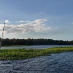
The spring transition is fully underway along the Florida East Coast, bringing climbing water temperatures in the mid-to-upper 70s and triggering aggressive feeding windows. Weather patterns are generally stabilizing, making this an ideal time to hit the water, though anglers should remain mindful of shifting coastal winds. Recent onshore breezes have pushed some sandy, muddy water against south-facing inlet structures, specifically around the south side of Sebastian Inlet. However, the north side remains protected with excellent water clarity. Offshore conditions are highly favorable for pelagic hunting, provided you monitor the afternoon sea breezes.
SPECIES INTEL
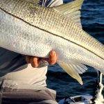
Primary Target: Snook and Mahi Mahi
Inshore, Snook are heavily staging around inlet structures, jetties, and bridge pilings, feeding aggressively before their summer spawning period. Offshore, the spring "Mahi Madness" is in full swing. Pelagic predators are riding the Gulf Stream north, providing excellent trolling opportunities just inside the ledge.
🎣Nautrek
Private Beta
J
M
R
100+ anglers on the waitlist
The fishing network where your reputation matters.
Find trusted captains, join real trips with cost splitting, and build your Angler Rank. Your spots stay private — you decide who sees your intel.
While the majority of anglers are distracted by the inlet Snook bite or the offshore Mahi run, Pompano are cruising the surf zones. Pockets of clean, green water just north of major inlets are holding excellent numbers of these hard-fighting, delicious fish.
Baitfish Report
Inshore forage is currently dominated by glass minnows and small mojarras. Offshore, flying fish are the primary catalyst for pelagic feeding; if you see flyers getting kicked up, predators are nearby.
TACTICAL STRATEGY
Where to Deploy
For inshore anglers, focus your efforts on the T-dock area and the North Jetty of Sebastian Inlet. The south side is currently holding too much silt from recent surf conditions. Offshore anglers should target the 120 to 180-foot depths, scanning for weedlines, floating debris, and temperature breaks along the ledge.
Lure and Bait Selection
Inshore Lures: Throw 1/2 oz to 1 oz bucktail jigs or soft plastic paddletails with a slow fall rate. Silver spoons are highly effective for schooling jacks and bluefish at the jetty tips.
Inshore Bait: Live mojarras, croakers, or select live shrimp are the ticket for slot-sized Snook. Fish them on a knocker rig or free-lined near the pilings.
Offshore Bait: Rigged ballyhoo—either naked or dressed with a pink or white skirt—slow-trolled behind the boat.
Color Patterns
Match the hatch with white, silver, or translucent patterns to mimic the prevalent glass minnows and mojarras. If you are forced to fish stained water on the outgoing tide, switch to chartreuse or rootbeer colors to increase your bait's silhouette visibility.
Timing
The Snook action heavily favors the incoming tide, particularly as cleaner ocean water pushes into the inlet. The bite peaks during the early evening and into the night. For offshore trolling, early morning departures are crucial to capitalize on the low-light bite and beat the midday heat.
Pro Tip: Water clarity dictates the inlet bite. If your primary spot is blown out and muddy from onshore winds, immediately relocate to the opposite side of the inlet or deeper structure where the concrete provides a buffer and holds cleaner water.
Pro Tip: When targeting offshore Mahi, do not just blindly run to the deep Gulf Stream. Start deploying your trolling spread the moment you see flying fish getting kicked up, even if you are only in 90 to 120 feet of water. You have to earn these fish by reading the water.
Pro Tip: If you are targeting the sleeper Pompano bite, stagger your surf fishing rods at different distances from the shoreline. Pompano often cruise the first trough just feet from the sand, while others hold on the outer sandbar.
REGULATIONS SNAPSHOT
Note: Always verify local regulations as they are subject to emergency closures.
Species
Season Status
Size Limit
Bag Limit
Snook (East Coast)
OPEN (Closes June 1)
28 to 32 inches
1 per harvester per day
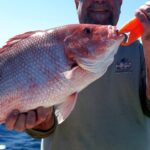
Florida Pompano
OPEN
Minimum 11 inches (fork length)
6 per harvester per day
Mahi Mahi (Dolphin)
OPEN
Minimum 20 inches (fork length)
10 per harvester per day
Attention Offshore Anglers: The highly anticipated Atlantic Red Snapper recreational season is slated for a specialized 39-day opening starting in late spring. Ensure your descending devices are rigged and ready, as they are legally required for reef fishing.
REGIONAL ALTERNATIVE
If the primary inlets are unfishable due to heavy boat traffic or deteriorating water clarity, push offshore out of Port Canaveral or Stuart. The nearshore reefs and wrecks starting at the 9-mile mark are holding excellent numbers of King Mackerel. Drift free-lined live pogies (menhaden) over the structure. If pogies are scarce, slow-trolling deep-diving plugs over the wrecks will reliably trigger violent Kingfish strikes. This provides a high-action backup plan that avoids the inshore crowds and muddy inlet water.
Tight lines!
Editor's Choice: Must-Have Gear
FISHINGSIR Next-Gen Waterproof Chest Waders
★★★★★4.4 (7,370+ reviews)
2-Ply Tech: Upgraded nylon with 2.5x higher density than standard fabrics.
100% Waterproof: Lab-approved intrusion resistance with taped visible seams.
Ultra-Lightweight: Designed for all-day comfort while hunting or fishing.
As an Amazon Associate I earn from qualifying purchases. #ad
Loading forecast...
Live Fishing Conditions: Tides, Weather & Waves
Get real‑time tides, marine weather, swell and solunar activity for each spot so you know exactly when conditions line up for your best chance at a bite.
🎣
Florida East Coast
Loading coordinates...
🌤️
WEATHER CONDITIONS
--°F
--°C
Loading...
🌡️
Feels Like--°F--°C
💧
Humidity--%
💨
Wind-- mph-- km/h
🧭
Direction--
📊
Pressure-- inHg-- hPa
☀️
UV Index--
🌊
MARINE CONDITIONS
🌊Wave Height
-- ft
-- m
Loading...
🧭Wave Direction
--°
Loading...
⏱️Wave Period
-- s
Loading...
📈Tide Status
-- ft
-- m
Loading...
🌙
LUNAR & SOLUNAR
🌕
Loading...
Illumination: --%
Major Period--:-- - --:----:-- - --:--
Minor Period--:-- - --:----:-- - --:--
🌅Sunrise--:--
🌇Sunset--:--
📅
24-HOUR FORECAST
Loading fishing conditions...
Fishing Spots Map
🎣
Book a Fishing Charter near Florida East Coast Fishing Report Today 🎣
Local guides & charters. Verified captains, instant booking, best price guaranteed.
There was an error loading the map. Please try refreshing the page.
Info
Local Access & Facilities
The Florida East Coast fishery, specifically centered around the sprawling estuary systems of Jacksonville and the historic St. Johns River, offers a complex tactical environment for the serious angler. This is not merely a coastline; it is a convergence of massive salt marshes, hardwood hammocks, and the open Atlantic. The topography here is defined by the interplay between the deep river channels and the shallow, grassy flats of the Timucuan Ecological & Historic Preserve. Anglers here must be versatile, ready to switch from working the backwater creeks for Redfish to punching out of the inlets for pelagic species along the Atlantic trade routes.
The atmosphere is a distinct blend of Southern history and rugged coastal wilderness. Unlike the manicured resort harbors further south, this region retains a raw, "Old Florida" feel, particularly within the 6,000-year-old human history preserved at Fort Caroline and the surrounding wetlands. It is a place where the industrial pulse of a major port city fades quickly into the silence of the salt marsh. The primary draw for expert captains here is the year-round inshore game, though the proximity to the Gulf Stream makes it a strategic launch point for offshore heavy hitters when the weather window opens.
Access & Getting There
Navigating to the prime launch points requires a strategic approach to the local highway infrastructure. The primary artery is I-95, but the seasoned angler knows that the coastal route, State Route A1A, provides the most direct access to the beach-side ramps and the historic district. Traffic around Jacksonville can be dense, particularly during the morning rush; plan to clear the downtown interchange before 6:00 AM to ensure a stress-free arrival at the ramp. Accessing the Timucuan Preserve requires taking the Southside Connector to Merrill Road, which transitions into Fort Caroline Road.
💡 Captain's Tip: Trailer Management
While urban parking is available, be highly selective. Golden Isles Valet Parking is rated highly but explicitly noted to "Avoid with trailers." For heavy rigs, stick to the dedicated lots at the larger marinas or the surface lots further from the dense valet zones.
Launch realities in this region vary significantly between the developed coast and the protected preserve. The Timucuan Ecological & Historic Preserve offers access to unspoiled wetlands, but the infrastructure is designed for low-impact usage. Kayak and canoe launches are prevalent, with a notable launch point located approximately 3 miles from the central hub. For trailer boats, the ramps can be tidal-dependent; low tide in the marsh creeks can leave you grounded in mud, so consult the tide tables religiously before committing to a backwater creek.
Weather is the dictating factor for access here. The region sits exposed to the Atlantic trade winds. When the wind blows from the Northeast, the inlets can become treacherous, and the shallow marshes chop up quickly. In these conditions, utilizing the leeward launches within the river system or the protected waters near Kingsley Plantation is a prudent move. Parking at popular spots like the Touchdown Lot or near Fort Caroline fills rapidly on weekends, so a "dawn patrol" arrival is essential for securing a trailer-friendly space.
Florida East Coast Pre-Trip Checklist
Facilities & Amenities
The infrastructure in Jacksonville and St. Augustine caters to a wide spectrum of anglers, from shore-bound casuals to offshore charter captains. It is critical to note that while general amenities are plentiful, specialized pro shops are scattered. The Sinker Guy, located on Tynan Avenue, is a known entity for terminal tackle, while Jacksonville Beach Bait & Tackle on 20th Street North serves the coastal surf crowd. For those heading further south towards Green Cove Springs, Reverence Outdoors provides essential gear support.
Facility Name
Type
Distance
Key Logistics
The Sinker Guy
Bait & Tackle
9.2 miles
Opens 10 AM (Late for dawn patrol)
Jax Beach Bait & Tackle
Bait & Tackle
10.7 miles
Opens 6 AM (Ideal for early starts)
Always Hookin Charters
Fleet
11.2 miles
Located on Ocean St; 24-hour ops
One Ocean Resort & Spa
Lodging
13.2 miles
High-end; 24-hour access
The local charter fleet is robust, with reputable operations like Always Hookin Fishing Charters and North Florida Fishing Charters based out of Ocean Street. These outfits are known for their versatility, targeting both inshore drum and offshore pelagics. If you are looking for local intelligence or a guide to navigate the complex marsh tides, these are the hubs to visit. Note that some smaller marina facilities may lack high-speed diesel pumps; captains running large sportfishers should verify fuel availability at the major commercial docks before leaving the inlet.
💡 Captain's Tip: Fuel & Ice Logistics
There is no dedicated fuel dock explicitly listed for the remote Timucuan Preserve launch points. Top off your tanks at highway stations along I-95 or A1A before entering the preserve boundaries to avoid a dry tank in the marsh.
For lodging, the options range from the historic to the tactical. The Casa Marina Hotel and Restaurant in Jacksonville Beach is the "Grand Lady of the Beach," offering a historic 1920s atmosphere for anglers who appreciate luxury after a long day on the water. For those prioritizing logistics and early exits, Stadium Base Camp offers proximity to the city center. Military personnel or veterans should look into Pelican Roost RV Park, which offers excellent amenities and secure access near the water.
Permits, Regulations & Fees
Fishing this region places you in a matrix of state and federal jurisdictions. The primary regulatory body is the State Fishing Agency, and strict adherence to size and bag limits is enforced. However, the overlay of the Timucuan Ecological & Historic Preserve adds a layer of federal oversight. This area protects one of the last unspoiled coastal wetlands on the Atlantic Coast. The regulations here are not just about conservation; they are about preserving 6,000 years of human history.
Special care must be taken when fishing near historical structures. The Kingsley Plantation and Fort Caroline National Memorial are sensitive cultural sites. It is imperative to respect the "No Wake" zones and shoreline buffers in these areas. The tabby cabins and dune systems, such as the Nana dune at American Beach, are federally protected. Anchoring on or disturbing submerged historical artifacts is a severe federal offense. Treat these waters with the same reverence you would a sanctuary.
There are generally no permit entrances for the preserve itself, but specific activities may require coordination with the National Park Service. Boaters should be aware that the Castillo De San Marcos National Monument further south in St. Augustine also has strict perimeter rules regarding vessel approach distances. Always carry your valid Florida saltwater fishing license and a federal HMS permit if you plan to cross into federal waters offshore.
Events & Seasonal Information
The rhythm of this fishery is dictated by the seasons of the Atlantic. Summer brings calmer seas and the arrival of tarpon and sharks along the beaches, while the cooler months trigger the schooling of Redfish in the shallows. The area is historically significant as part of the Atlantic trade route, meaning the water here has been a thoroughfare for mariners for over 450 years. This historical depth often coincides with modern seasonal gatherings and local tournaments that celebrate the maritime heritage of the First Coast.
Timing your day is critical. The trade winds typically pick up by mid-morning, around 10:00 AM. For those targeting spotted seatrout or tailing reds in the Theodore Roosevelt Area wetlands, the window from dawn until the wind line hits is your "golden hour." Conversely, the summer heat can be oppressive in the marsh; afternoon thunderstorms are clockwork reliable. Plan to be off the exposed water or near a sheltered marina by 2:00 PM during the humid months.
Contact Information & Resources
For the most current information on water conditions and park access, the Timucuan Preserve Visitor Center at Fort Caroline is your primary resource. They can be reached at (904) 641-7155. For questions regarding the southern historic districts, contact the Castillo De San Marcos ranger station at (904) 829-6506. In the event of an on-water emergency, standard VHF Channel 16 protocols apply, but be aware that cell signal can be spotty in the deep creeks of the preserve.
Self-reliance is the rule of the road here. Carry ample water, sun protection, and a backup communication device. The history of this coast is written in survival; ensure your trip doesn't become a statistic.
For precise locations, real-time weather data, and detailed facility maps, consult the live dashboard and interactive widgets below.
🎣
Florida East Coast
Jacksonville • Florida • 30.1891, -81.5500
🅿️
Parking
5
Golden Isles Valet Parking
⭐ 5.03.6 mi
📍11250 Old St Augustine Rd, Jacksonville, FL 32257, USA
Our spot reports combine data-driven forecasts with curated local information. The forecast is generated by our proprietary Fishing Score algorithm (0–100%), which analyzes real-time data from Open-Meteo API, validated against NOAA CO-OPS tide gauges and USGS water-monitoring stations. The model weights tide dynamics (35%), wave energy (25%), wind patterns (20%) and time of day (20%)—factors shown to influence fish feeding behavior through marine-biology research and decades of charter log data.
Access, facilities and services information for each fishing spot is sourced from official datasets such as Recreation.gov (RIDB), state park & wildlife agencies, and geospatial providers like Google Maps. These sections undergo scheduled re-validation every 3–6 months to ensure that boat ramps, park access, contact details and local services remain accurate.
Narrative sections (catches, seasonal behavior, local tips) are synthesized from these data sources and refined following the Fishing Reports Today editorial guidelines, combining bibliographic research from ichthyology and oceanography with expert angler experience. Our team reviews reports on a regular basis, while the forecast model itself updates every 6 hours for real-time accuracy.
⚠️ Important: Always verify current local regulations, access restrictions and weather conditions before fishing. These reports are intended as a planning aid, not a guarantee of catches or safety. When in doubt, contact local authorities or park managers listed on the page.
To provide the best experiences, we use technologies like cookies to store and/or access device information. Consenting to these technologies will allow us to process data such as browsing behavior or unique IDs on this site. Not consenting or withdrawing consent, may adversely affect certain features and functions.
Functional Always active
The technical storage or access is strictly necessary for the legitimate purpose of enabling the use of a specific service explicitly requested by the subscriber or user, or for the sole purpose of carrying out the transmission of a communication over an electronic communications network.
Preferences
The technical storage or access is necessary for the legitimate purpose of storing preferences that are not requested by the subscriber or user.
Statistics
The technical storage or access that is used exclusively for statistical purposes.The technical storage or access that is used exclusively for anonymous statistical purposes. Without a subpoena, voluntary compliance on the part of your Internet Service Provider, or additional records from a third party, information stored or retrieved for this purpose alone cannot usually be used to identify you.
Marketing & Affiliates
The technical storage or access is required to create user profiles to send advertising, or to track the user on a website or across several websites for similar marketing purposes, including affiliate tracking for products recommended in our reports.


Leave a Reply