Cape Canaveral Summer Fishing Report: Offshore Kings and Inshore Bulls
Welcome to the ultimate summer fishing breakdown for Cape Canaveral, Florida. As the water temperatures peak and the ocean currents push baitfish closer to the Space Coast, we are entering one of the most dynamic fishing periods of the year. Whether you are running offshore to the ledges or stalking the skinny water of the local lagoons, this report delivers the tactical intelligence you need to bend rods and fill coolers. The summer bite is heavily dictated by bait migration and weather windows, so preparation and timing are your greatest assets.
1. GO/NO-GO STATUS
Verdict: CAUTION - GO EARLY
Summer on the Space Coast brings a classic, predictable weather pattern that demands respect. Mornings typically offer slick, glass-like conditions, making for an effortless run offshore. However, this is also the season of volatile, fast-moving afternoon thunderstorms. Heat and humidity fuel these squalls, which can produce dangerous lightning and sudden, violent wind shifts.
From the editor
Tired of fishing with strangers you can’t trust?
Nautrek is the first social network for serious anglers — verified partners, real trips, cost splitting and intel sharing without burning your spots. Private beta now open.
If you are heading out past the port jetties, the offshore sea state is currently manageable, with swells averaging 2 to 3 feet at 7 to 9-second intervals. This is highly fishable for most center consoles in the 22-foot and larger class. However, the golden rule of summer fishing in Cape Canaveral is to leave the dock in the dark and be heading back to port by 1:00 PM or 2:00 PM at the latest to dodge the afternoon storms. Always monitor your marine weather app and keep a close eye on the western horizon.
Pro Tip:Do not rely solely on generalized weather forecasts. Use real-time radar and VHF channel 16 to monitor storm developments. If the sky turns dark over the mainland, it is time to pull lines and point the bow home.
2. SPECIES INTEL
Primary Target: King Mackerel (Kingfish)
The undisputed heavyweight champion of the Cape Canaveral summer is the King Mackerel. These toothy pelagics have arrived in massive numbers, patrolling the nearshore and offshore reefs in search of schooling bait. They are aggressive, fast, and provide blistering runs that will test your drag systems. You will find them stacked anywhere from 3 miles to 15 miles off the beach, holding near temperature breaks and structural drop-offs.
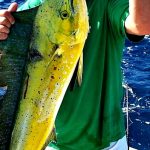
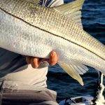
Sleeper Pick: Nighttime Snook
While most anglers are baking in the midday sun chasing offshore species, the savvy locals are waiting for the sun to set. Snook stack up heavily around the Port Canaveral rock jetties and the channel drop-offs during the summer months. Fishing for these linesiders under the cover of darkness not only beats the brutal Florida heat but also aligns with their peak feeding and spawning behaviors. Many visiting anglers completely overlook this world-class urban fishery.
Baitfish Report
The forage base is currently thick and highly visible. Massive pods of Atlantic Menhaden (locally known as pogies) are flipping on the surface just outside the surf zone and near the port entrance. You can easily spot these schools by looking for diving pelicans and dark, nervous patches of water. Threadfin herring and Spanish sardines are also schooling heavily over the nearshore reefs. Matching the hatch is critical right now; if you find the pogies, you will find the predators. To load your livewell, a custom 10-foot to 12-foot cast net with 1.5 pounds of lead per radius foot is ideal for getting down quickly over the fast-moving pods before they can scatter.
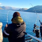
3. TACTICAL STRATEGY
Where to Deploy
For the King Mackerel bite, push out to the 40 to 90-foot depth range. The 8A Reef, located approximately 14 miles out of Port Canaveral, is currently a major holding zone. If you want to stay closer, work the Canaveral Ledge or the nearshore hard bottom areas just 3 to 5 miles off the beach. Look for diving birds and surface boils to pinpoint the bait pods. For the nighttime Snook, focus your efforts on the outgoing tide at the tip of the Port Canaveral jetties, casting parallel to the rocks where the current creates a natural eddy.
Lure and Bait Selection
When targeting Kings, live bait slow-trolling is the most lethal presentation. Cast net a livewell full of 5 to 7-inch pogies first thing in the morning. Rig them on a stinger rig utilizing a 40-pound test stranded wire leader. Use a 2/0 live bait hook through the nose and a #4 treble hook trailing near the dorsal fin. Kingfish have notoriously soft mouths and razor-sharp teeth, making this specific rig non-negotiable. When a King strikes, do not hammer the drag down. Let the fish make its blistering initial run, keeping steady pressure, and slowly pump the fish to the boat.
If you prefer artificials, a 1-ounce white bucktail jig tipped with a curly tail grub can be highly effective when vertically jigged over the reefs for bottom species and passing pelagics. For deep dropping or working the middle column, a 150-gram slow pitch jig in blue and silver is producing vicious strikes from Amberjack, Grouper, and occasional Cobia. Drop the jig all the way to the 8A Reef bottom, and use a rhythmic, upward sweeping motion to make the jig flutter like a wounded baitfish.
For the jetty Snook, a 1.5-ounce flair hawk jig in chartreuse and white is the ultimate weapon. Cast it up-current and let it bounce along the rocky bottom. You will lose some jigs to the structure, but that is exactly where the monster Snook are lying in ambush. Alternatively, free-lining a live jumbo shrimp or a select-sized croaker into the shadow lines of the port lights using a 40-pound fluorocarbon leader will trigger explosive bites.
Timing the Bite
The Kingfish bite is heavily concentrated in the first three hours of daylight. Be on your numbers and have baits in the water as the sun breaks the horizon. For the inshore and jetty bite, tidal movement is everything. The last two hours of the incoming tide and the first two hours of the outgoing tide are producing the most consistent action, especially when those tides align with early morning or late evening hours.
Pro Tip:When slow-trolling live pogies for Kingfish, bump your boat in and out of gear to maintain a speed of 1 to 2 knots. If your baits are spinning, you are moving too fast. The bait should swim naturally to entice a strike.
4. REGULATIONS SNAPSHOT
Florida saltwater regulations are strictly enforced, and summer brings specific seasonal closures and changes. Always verify with the FWC before harvesting, as federal water regulations can shift rapidly due to ongoing management decisions.
Species
Size Limit
Bag Limit
Season Status
Red Snapper (State Waters)
20-inch minimum
2 per person
Open (Federal waters subject to change/injunctions)
King Mackerel
24-inch minimum (fork length)
3 per person
Open year-round
Snook (Atlantic)
28 to 32-inch slot
1 per person
Catch and Release Only (Summer Closure)
Red Drum (Redfish)
18 to 27-inch slot
Catch and Release
Check specific zone restrictions
5. REGIONAL ALTERNATIVE
If the offshore winds kick up and push the sea state past the 4-foot mark, venturing out of Port Canaveral becomes unsafe and unproductive. When the ocean is a no-go, pivot to the world-renowned inshore waters of the Banana River or the Mosquito Lagoon. These sheltered estuaries offer hundreds of miles of fishable shoreline regardless of the ocean swell.
Launch your skiff or kayak at Rodney S. Ketcham Park or the Pineda Causeway ramps. The target species here will be Bull Redfish and Speckled Sea Trout. The tactical approach shifts dramatically in the lagoon: ditch the heavy offshore tackle and pick up a medium-light spinning setup. Work the shallow grass flats in 2 to 4 feet of water early in the morning using a topwater walking bait, like a Zara Spook in a bone or mullet color pattern. As the sun rises and the topwater bite fades, switch to a 1/4-ounce weedless gold spoon or a soft plastic paddletail on a 1/8-ounce jig head, working the edges of the mangrove shorelines and sandy potholes. This backup plan often results in some of the most visually stunning surface strikes you will ever experience.
Pro Tip:When fishing the shallow grass flats of the Banana River, stealth is your best weapon. Cut your outboard engine at least a hundred yards from your target zone and use a push pole or a trolling motor on its lowest setting. Redfish are incredibly pressure-sensitive in the summer heat and will spook at the sound of hull slap or loud voices.
Tight lines!
Editor's Choice: Must-Have Gear
FISHINGSIR Next-Gen Waterproof Chest Waders
★★★★★4.4 (7,370+ reviews)
2-Ply Tech: Upgraded nylon with 2.5x higher density than standard fabrics.
100% Waterproof: Lab-approved intrusion resistance with taped visible seams.
Ultra-Lightweight: Designed for all-day comfort while hunting or fishing.
As an Amazon Associate I earn from qualifying purchases. #ad
Loading forecast...
Live Fishing Conditions: Tides, Weather & Waves
Get real‑time tides, marine weather, swell and solunar activity for each spot so you know exactly when conditions line up for your best chance at a bite.
🎣
Cape Canaveral
Loading coordinates...
🌤️
WEATHER CONDITIONS
--°F
--°C
Loading...
🌡️
Feels Like--°F--°C
💧
Humidity--%
💨
Wind-- mph-- km/h
🧭
Direction--
📊
Pressure-- inHg-- hPa
☀️
UV Index--
🌊
MARINE CONDITIONS
🌊Wave Height
-- ft
-- m
Loading...
🧭Wave Direction
--°
Loading...
⏱️Wave Period
-- s
Loading...
📈Tide Status
-- ft
-- m
Loading...
🌙
LUNAR & SOLUNAR
🌕
Loading...
Illumination: --%
Major Period--:-- - --:----:-- - --:--
Minor Period--:-- - --:----:-- - --:--
🌅Sunrise--:--
🌇Sunset--:--
📅
24-HOUR FORECAST
Loading fishing conditions...
Fishing Spots Map
🎣
Book a Fishing Charter near Cape Canaveral Fishing Report Today 🎣
Local guides & charters. Verified captains, instant booking, best price guaranteed.
There was an error loading the map. Please try refreshing the page.
Info
Local Access & Facilities
Cape Canaveral represents a unique intersection of high-technology and primal nature, offering a fishery that is as diverse as it is historically significant. Situated on Florida’s "Space Coast," this area is defined not just by the Atlantic surf, but by the sprawling, brackish labyrinth of the Merritt Island National Wildlife Refuge. For the serious angler, the allure here is the juxtaposition of sight-fishing for tailing redfish in the shadow of a launch pad, or heading offshore from a coast that has launched humanity to the stars. The atmosphere is distinct: a blend of rugged, undeveloped barrier island scrub, expansive seagrass beds, and the deep blue potential of the Atlantic shelf.
The vibe here shifts dramatically depending on where you launch. To the north, the Refuge offers solitude and silence, broken only by the splash of a Gator or the roar of a rocket engine. To the south, the energy is more frantic, driven by the commercial and recreational bustle of Port Canaveral. Experienced captains know that this is a dynamic ecosystem where the Mosquito Lagoon meets the ocean. Whether you are targeting inshore slam species like snook, redfish, and trout, or gearing up for pelagics offshore, understanding the logistical layout of this dual-nature fishery is the first step to a successful day on the water.
This is not a manicured resort fishery; it is a working coast. The bottom topography varies from the shallow, grassy flats of the Indian River Lagoon system to the shifting sandbars of the Atlantic beaches. Success here requires respecting the tides, the wind, and the strict regulations that govern these federally protected waters. It is a place where preparation pays dividends, and where the seasoned angler can find world-class action if they know how to navigate the local infrastructure.
Access & Getting There
Reaching the prime fishing grounds of Cape Canaveral generally involves navigating the corridors connecting the mainland to the barrier islands. The primary artery for those heading to the Merritt Island National Wildlife Refuge is State Road 406 (Garden Street) via I-95 Exit 220 in Titusville. This route takes you east across the Max Brewer Causeway Bridge, a critical choke point that offers your first look at the water conditions. Traffic on the causeway can be heavy during launch windows or weekends, so seasoned locals advise checking launch schedules before trailering a boat. If you are targeting the southern end or the Port, the approach is typically via the Bennett Causeway (SR 528), which handles heavier commercial traffic.
💡 Captain's Tip: Wind Awareness
The Max Brewer Causeway is highly exposed. If you are towing a skiff or a light bay boat, be cautious when winds exceed 15 knots, as crosswinds on the bridge can be severe. Always check the flags at the marina before committing to a specific ramp.
Launch realities in this region vary significantly. The official access point within the Refuge (ID 1513) serves as a primary gateway for backcountry anglers. While the ramps are generally serviceable, the "Launch Realities" here include potential slickness at low tide and limited amenities. The data indicates that several local ramps do not have restrooms or fish cleaning stations immediately on-site, so self-reliance is key. You are entering a Wildlife Refuge, not a marina; expect nature, not luxury. Parking at these access points, particularly near the Adams Ave Beach Access (approx. 5.9 miles from the hub), fills rapidly. The "dawn patrol" mentality is essential here; arriving after 6:00 AM on a weekend often results in a frustrating search for a spot.
Parking security and logistics require a strategic approach. While there are commercial lots like Lots of Honor and Park N Cruise (approx. 8.9 miles away), these are often geared towards cruise ship passengers rather than boat trailers. For the angler towing a rig, sticking to the designated boat ramp parking within the Refuge or the public ramps near the causeway is vital. Be mindful that the Refuge is federal land; adhere strictly to parking boundaries to avoid fines. The surfaces can be a mix of paved and packed dirt/sand, so ensure your tow vehicle has adequate traction if recent rains have softened the shoulders.
Cape Canaveral Pre-Trip Checklist
Facilities & Amenities
The infrastructure around Cape Canaveral caters to two distinct crowds: the heavy-tackle offshore fleet and the technical inshore specialist. Understanding where to stop for supplies can save you an hour of running around in the dark. For anglers coming from the mainland (Titusville side), Space Coast Bait & Tackle (Captain Hooks) is the strategic stop. Located on Garden Street, they open at 5:00 AM, making them the only reliable option for grabbing live shrimp or frozen bait before hitting the Refuge ramps at first light. Their location, roughly 21 miles from the central Cape spot but directly on the route to the Refuge, makes them indispensable.
On the island/beach side, the Cocoa Beach Fishing Center and Cocoa Beach Bait & Tackle Rentals serve the fleet closer to the Port. The Fishing Center opens at 6:00 AM and is located about 7 miles from the core fishing zones. If you need specialized gear or rentals, these shops are well-equipped, but they open an hour later than their mainland counterpart. Florida Water Sports is another option, though their hours may vary. The table below details the logistical spread of these critical resources.
Facility Name
Specialty
Distance from Center
Dawn Patrol Access
Space Coast Bait & Tackle
Live Bait / Inshore Gear
21.0 miles (Mainland)
5:00 AM (Excellent)
Cocoa Beach Fishing Center
Offshore / Heavy Tackle
7.1 miles (Beachside)
6:00 AM (Good)
Cocoa Beach Bait & Tackle
General Tackle / Rentals
10.4 miles
9:00 AM (Late)
Regarding the local fleet, the area is home to top-tier charter operations. Fired Up Fishing Charters and Fin & Fly Fishing Charters are located within 10 miles of the main access points and are highly rated for their knowledge of the seasonal pelagic runs. Captain Micah Fishing Charters operates out of Titusville, positioning them perfectly for backcountry Refuge trips. If you are looking to book a guide, these operators have the specific local knowledge required to navigate the complex security zones and shifting shoals.
💡 Captain's Tip: The "Negative Knowledge" Check
Be aware that many of the smaller, unnamed boat ramps and shore access points in the Refuge area do not have restrooms or fresh water. The data explicitly flags amenities as "false" for several access coordinates. Bring ample water and plan your comfort stops at the bait shops before launching.
For lodging, proximity to the launch is the main factor. Discovery Beach Resort offers a comfortable stay just 7.2 miles away, but for those towing boats who prefer a camp-and-fish setup, the Indian River RV Park in Titusville (20.2 miles) or Wickham Park (21.5 miles) offer trailer-friendly accommodations. Note that staying in Titusville positions you better for the Refuge, while staying in Cocoa Beach positions you better for the Port and offshore access.
Permits, Regulations & Fees
Fishing in the Cape Canaveral area, particularly within the Merritt Island National Wildlife Refuge, requires a heightened level of regulatory awareness. This is not just a fishery; it is a federally managed overlay of the Kennedy Space Center. The "Why" behind the strict rules here is twofold: the conservation of sensitive estuarine habitats that support manatees and bird populations, and the national security requirements of the space program. Anglers must respect that they are guests in a sanctuary.
While a standard Florida saltwater fishing license is required (managed by the State Fishing Agency), specific activities within the Refuge may require a dedicated Refuge Permit. Although the current data snapshot indicates "Permit Required: Null," seasoned visitors know to always check the specific Refuge signage or the Visitor Center (approx. 18 miles from the spot) for the most current pass requirements, especially for boat launching. There are distinct zones within the waterways that are closed to public access for security reasons. These "Security Zones" are strictly enforced by federal agents. Ignorance of a closure zone can lead to severe penalties and the immediate end of your fishing trip.
Cultural and environmental respect is paramount. The concept of "Kapu"—or sacred restriction—applies here in the form of "No Motor Zones" and "Pole & Troll Zones." These areas are established to protect the seagrass beds from prop scarring. Running a combustion engine in a pole-and-troll zone is a major violation of local etiquette and law. Silence is a tool here; the quieter you are, the less you disturb the wildlife and the better your fishing will be. Furthermore, do not approach or harass the wildlife, particularly the alligators and manatees often seen in the canals.
Events & Seasonal Information
The rhythm of the Cape Canaveral fishery is dictated by the seasons and the weather patterns of the Atlantic. Summer brings calmer seas and the famous runs of Kingfish and Tarpon along the beaches, while the cooler months often push Redfish and Trout into the deeper holes and canals of the Refuge. The transition periods—Spring and Fall—are often the most productive for the inshore "slam."
While specific tournament dates fluctuate, the area is a hotbed for Redfish tournaments and offshore Billfish events during the warmer months. The presence of high-caliber fleets like Fired Up and Fin & Fly suggests a competitive environment where local knowledge is guarded. If you are visiting during a major tournament window, expect ramp traffic to triple and bait supplies to dwindle by sunrise.
💡 Captain's Tip: The 10:00 AM Rule
On the flats and open basins of the Lagoon, the trade winds typically begin to stiffen around 10:00 AM. Plan your sight-fishing for the early morning slick calm. Once the chop picks up, switch to bait or drift fishing tactics.
Timing your day is critical. With bait shops like Captain Hooks opening at 5:00 AM, the local rhythm is undeniably early. The summer heat can be oppressive by noon, and the afternoon thunderstorms are a daily hazard in Florida. The smartest anglers are off the water or seeking shelter by 2:00 PM during the summer season.
Contact Information & Resources
For official information regarding access, closures, and current conditions, the primary point of contact is the Merritt Island National Wildlife Refuge. They can be reached at 321-861-5601 or via email at MerrittIsland@fws.gov. The Visitor Center is a valuable resource for maps and current "No Motor Zone" delineations.
Safety in this area is largely a matter of self-reliance. Cell reception can be spotty in the deep backcountry of the Refuge. Always file a float plan with someone on land. In the event of an emergency on the water, the U.S. Coast Guard and local marine patrol monitor VHF Channel 16. Given the abundance of oyster bars and submerged obstacles, carrying a spare prop and a push pole is highly recommended for small boaters.
For precise locations of the boat ramps, real-time weather overlays, and specific coordinates for the bait shops mentioned above, consult the live dashboard and interactive maps below.
Our spot reports combine data-driven forecasts with curated local information. The forecast is generated by our proprietary Fishing Score algorithm (0–100%), which analyzes real-time data from Open-Meteo API, validated against NOAA CO-OPS tide gauges and USGS water-monitoring stations. The model weights tide dynamics (35%), wave energy (25%), wind patterns (20%) and time of day (20%)—factors shown to influence fish feeding behavior through marine-biology research and decades of charter log data.
Access, facilities and services information for each fishing spot is sourced from official datasets such as Recreation.gov (RIDB), state park & wildlife agencies, and geospatial providers like Google Maps. These sections undergo scheduled re-validation every 3–6 months to ensure that boat ramps, park access, contact details and local services remain accurate.
Narrative sections (catches, seasonal behavior, local tips) are synthesized from these data sources and refined following the Fishing Reports Today editorial guidelines, combining bibliographic research from ichthyology and oceanography with expert angler experience. Our team reviews reports on a regular basis, while the forecast model itself updates every 6 hours for real-time accuracy.
⚠️ Important: Always verify current local regulations, access restrictions and weather conditions before fishing. These reports are intended as a planning aid, not a guarantee of catches or safety. When in doubt, contact local authorities or park managers listed on the page.
To provide the best experiences, we use technologies like cookies to store and/or access device information. Consenting to these technologies will allow us to process data such as browsing behavior or unique IDs on this site. Not consenting or withdrawing consent, may adversely affect certain features and functions.
Functional Always active
The technical storage or access is strictly necessary for the legitimate purpose of enabling the use of a specific service explicitly requested by the subscriber or user, or for the sole purpose of carrying out the transmission of a communication over an electronic communications network.
Preferences
The technical storage or access is necessary for the legitimate purpose of storing preferences that are not requested by the subscriber or user.
Statistics
The technical storage or access that is used exclusively for statistical purposes.The technical storage or access that is used exclusively for anonymous statistical purposes. Without a subpoena, voluntary compliance on the part of your Internet Service Provider, or additional records from a third party, information stored or retrieved for this purpose alone cannot usually be used to identify you.
Marketing & Affiliates
The technical storage or access is required to create user profiles to send advertising, or to track the user on a website or across several websites for similar marketing purposes, including affiliate tracking for products recommended in our reports.


Leave a Reply