
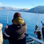
Situated high on the northern slopes of Pikes Peak, Crystal Creek Reservoir offers a distinct alpine angling experience that separates the casual weekend warrior from the dedicated high-country technician. This fishery is defined by its rugged granite surroundings and thin mountain air, sitting within the Pikes Peak Highway corridor. Unlike the manicured reservoirs found at lower elevations, Crystal Creek demands a respect for altitude and rapidly changing weather conditions. The water here is often crystal clear, reflecting the imposing silhouette of the 14,115-foot summit above, creating a visual backdrop that rivals the quality of the fishing itself.
The atmosphere at Crystal Creek is one of raw, high-altitude serenity, punctuated by the mechanical whine of vehicles ascending the famous toll road. For the expert angler, this location presents a technical challenge; the clarity of the water requires stealthy presentations and light fluorocarbon leaders. While the reservoir is easily accessible from the highway, the steep banks and rocky shorelines require sure footing. The primary draw here is the opportunity to target cold-water species in an environment that feels significantly more remote than its mileage from Colorado Springs would suggest. It is a fishery where the biting wind and intense UV exposure are prices paid for access to pristine water.
Seasoned captains and local guides view this reservoir as a strategic location. It serves as a testing ground for high-country tactics without the need for a backcountry hike. The proximity to Cascade-Chipita Park and the broader Pikes Peak region means that while you are fishing in the clouds, you remain tethered to civilization. However, the logistical reality of fishing a toll road reservoir requires specific planning regarding gate times and traffic flows, distinct from open-access state parks. This is a venue for the angler who appreciates the intersection of accessible infrastructure and harsh, beautiful mountain geography.
Access & Getting There
Navigating the Pikes Peak Highway
Reaching Crystal Creek Reservoir involves more than a standard commute; it requires navigating the Pikes Peak Highway, a toll road that serves as one of Colorado's premier tourist attractions. The primary route begins in Cascade, just off Highway 24. Expert anglers know that the "commute" here is dictated entirely by the toll gate hours and the volume of tourist traffic. During the peak summer months, the line to enter the highway can back up significantly by mid-morning. To maximize time on the water, you must treat the toll gate opening time as your absolute launch window. The drive itself is steep and winding, demanding a vehicle in good condition, particularly regarding braking systems for the descent.
💡 Captain's Tip: The Alpine Start
The Pikes Peak Highway creates a hard "start time" for your fishing day. Arrive at the toll gate 30 minutes before it opens. Not only will you beat the convoy of tourists heading to the summit, but you will also get lines in the water during that critical dawn window before the high-altitude sun becomes too intense and pushes the fish deep.
Launch Realities and Shoreline Approaches
Unlike lower elevation reservoirs with massive concrete ramps and expansive marinas, Crystal Creek is a more intimate affair. The data indicates that formal boat access points are limited, and the primary approach here is often from the shore or via small, hand-launched craft if permitted by current regulations. The terrain surrounding the water is rocky and uneven. Anglers carrying heavy gear or coolers should be prepared for a short but potentially breathless hike from the pull-offs to the water's edge due to the elevation. The North Catamount Reservoir Parking Lot serves as a key reference point in the area, located approximately one mile away, indicating that parking is generally available but may require a walk to reach specific shoreline hotspots. The "launch" reality here is less about backing a trailer down a ramp and more about strategic parking at designated pull-outs along the highway.
High-Altitude Weather Contingencies
Weather is the single most critical factor dictating access at Crystal Creek. Located thousands of feet above sea level, this area is subject to violent and sudden weather shifts. A sunny morning can transform into a dangerous electrical storm by 1:00 PM. The prevailing winds, often accelerating down the slopes of Pikes Peak, can turn the reservoir surface into a chop that makes light-line casting difficult. When the winds exceed 15 to 20 miles per hour, the exposed nature of the reservoir offers little protection. In the event of lightning—a very real and frequent threat in the afternoons—immediate retreat to your vehicle is mandatory. The nearby Bottomless Pit Observation Site and Cascade Observation Site offer vantage points to assess incoming weather systems from the west before they hit the water level.
Parking and Security Strategy
Parking along the Pikes Peak Highway is strictly regulated to designated areas to protect the fragile alpine tundra and manage traffic flow. You cannot simply pull over onto the shoulder wherever you see rising fish. The North Catamount Reservoir Parking Lot provides a structured parking option nearby. Because this is a high-traffic tourist corridor, vehicle security is generally good, but the volume of passersby means you should never leave visible gear in your truck bed. Trailer maneuvering in these tight, high-elevation lots can be challenging, especially when the lots fill with rental cars and sightseers. Plan your exit strategy before you park; ensuring you can pull out forward is crucial when the lot becomes congested later in the day.
Crystal Creek Reservoir Pre-Trip Checklist
Facilities & Amenities
Local Gear and Tactical Support
While the reservoir itself is austere, the surrounding region hosts some of Colorado's finest fly and tackle shops. For immediate needs, the South Platte Fly Shop in Woodland Park is the critical tactical hub, located just over 5 miles from the water. This shop is essential for obtaining the specific fly patterns hatching at altitude, which often differ from those at lower elevations. For a more comprehensive outfitting experience, Angler's Covey in Colorado Springs (approximately 11 miles away) is an institution. They handle everything from high-end waders to specialized rod repairs. Ultimate Rod Case and Roadrunner Bait also service the area, ensuring that whether you are flinging flies or soaking bait, you have access to the necessary hardware. The proximity of these shops allows for a "dawn patrol" fishing session followed by a resupply run without ruining the day's logistics.
💡 Captain's Tip: Specialized Inventory
Don't rely on generic big-box selections for this water. Stop at South Platte Fly Shop in Woodland Park and ask specifically about the midge patterns for Crystal Creek. The clarity of the water here often demands size 22-24 midges that you likely don't have in your standard box.
Lodging and Base Camp Logistics
Accommodation options range from rugged to royalty. For the angler who wants to stay close to the action and doesn't mind a physical challenge, Barr Camp offers a unique, hike-in lodging experience on the mountain itself. This is for the fit angler who views the hike as part of the adventure. For those requiring trailer access and traditional camping amenities, Mueller State Park and Grouse Mountain Campground are excellent base camps, located roughly 7 to 8 miles away. These sites offer the advantage of being acclimated to the elevation overnight. Conversely, for the angler traveling with a non-fishing spouse or seeking luxury after a day in the elements, The Broadmoor in Colorado Springs provides world-class amenities, though it sits about 13 miles from the fishing grounds. The commute from The Broadmoor to the toll gate is straightforward, making it a viable, albeit upscale, option.
Critical Gaps in Infrastructure
It is vital to recognize what is absent at Crystal Creek to prevent logistical failures. There is no fuel available on the Pikes Peak Highway. You must fill your tank in Cascade or Woodland Park before passing the toll gate. Running out of gas on this mountain road is an expensive and time-consuming error. Additionally, unlike the developed marinas at lower elevations, there are no fish cleaning stations or potable water sources immediately on the shoreline. Anglers must pack in all hydration and pack out all refuse. The Halfway Picnic Area provides a place to rest and eat, but it is not a commercial service center.
| Facility Name | Type | Distance | Key Notes |
|---|---|---|---|
| South Platte Fly Shop | Bait & Tackle | 5.2 miles | Closest tactical hub; opens 8:00 AM. |
| Angler's Covey | Bait & Tackle | 11.2 miles | Major outfitter; extensive inventory. |
| North Catamount Lot | Parking | 1.0 mile | Primary parking reference; no trailers advised. |
| Mueller State Park | Camping | 6.8 miles | Developed camping; showers and power. |
| Barr Camp | Lodging | 5.1 miles | Hike-in only; high altitude shelter. |
Permits, Regulations & Fees
The Toll Road and Access Fees
Accessing Crystal Creek Reservoir is inextricably linked to the Pikes Peak Highway toll system. This is not a free-access public road. A toll fee is required for every vehicle passing the gate, regardless of whether you intend to summit the mountain or stop at the reservoir. These fees contribute to the maintenance of the complex mountain road infrastructure and the conservation of the surrounding national forest lands. It is prudent to check current toll rates online before departure, as they can vary by season and vehicle occupancy. Furthermore, a valid Colorado fishing license is mandatory for all anglers, and standard state regulations regarding bag limits and possession apply unless specific site-specific rules are posted at the water's edge.
Conservation and Protected Zones
The area surrounding Crystal Creek is a sensitive high-alpine ecosystem. The land is managed in conjunction with the Pike National Forest and local utilities. Anglers must adhere strictly to "Leave No Trace" principles. The vegetation at this altitude has a very short growing season and recovers slowly from damage; therefore, creating new trails or trampling shoreline vegetation is strictly prohibited. While the Florissant Fossil Beds National Monument is located roughly 12 miles away and represents a different type of protected zone, the ethos of conservation permeates the entire region. Respect for the land also extends to the wildlife; bear activity is common, and proper food storage in vehicles is not just a suggestion, it is a safety requirement.
💡 Captain's Tip: Bear Aware
Never leave coolers or bait containers accessible in the bed of a pickup truck while you are down at the water. Black bears in the Pikes Peak region are active and intelligent. A cooler left in the open is an invitation for property damage and a lost lunch.
Cultural and Community Respect
The Pikes Peak region holds deep significance for local communities and indigenous history. While recreational use is encouraged, it is done so with the understanding that visitors are guests in a unique environment. The reservoir serves as part of the municipal water supply system, which often dictates stricter regulations regarding body contact with the water (swimming is frequently prohibited) and the types of bait or vessels allowed. Violating these "Kapu" or forbidden actions not only risks fines but threatens the continued access for the entire angling community. Always defer to the signage at the parking lot for the most current rules regarding bait restrictions, as these can change based on water quality concerns.
Events & Seasonal Information
The Alpine Rhythm
Fishing at Crystal Creek is entirely dictated by the alpine calendar. The "open water" season is significantly shorter here than in the valley below. Ice-out typically occurs later in the spring, and the water can begin to freeze as early as late October or November. The prime season runs from late June through September, when the air temperatures are manageable, and the insect hatches are most active. However, this window coincides with the peak tourist traffic on the highway. The savvy angler monitors the weather reports for the Cascade and Pikes Peak summit areas to predict the localized conditions at the reservoir.
Daily Weather Cycles
The daily rhythm on Pikes Peak is predictable to the locals but often surprises visitors. The mornings are generally calm and clear—this is the time for sight fishing and dry fly presentations. By 11:00 AM, the thermal winds begin to rise as the sun heats the rock face. By 1:00 PM during the summer monsoon season, thunderheads often build over the summit. Experienced captains plan their day to be off the water or in a safe location by early afternoon. Fishing through a high-altitude thunderstorm is not a sign of toughness; it is a significant safety risk due to lightning strikes on the exposed water.
Contact Information & Resources
Essential Agency Contacts
For the most accurate and up-to-date information regarding road conditions and access, the Pikes Peak Highway toll gate personnel are the primary resource. They control the physical access to the fishery. For questions regarding fishing regulations, stocking reports, and enforcement, Colorado Parks and Wildlife (CPW) is the governing authority. For broader camping and land use inquiries, the Royal Gorge Field Office (managing nearby areas like Shelf Road) can provide context on regional conditions, though they are located in Canon City. In case of emergency, cell service can be spotty in the canyon; always have a backup communication plan.
Safety and Self-Reliance
Self-reliance is paramount at Crystal Creek. The Cascade Observation Site and Bottomless Pit Observation Site are nearby landmarks, but they are not medical facilities. Altitude sickness is a real possibility for visitors coming from sea level; hydration is the best prevention. Ensure your vehicle is equipped with basic emergency supplies, including warm clothing, as temperatures can drop 30 degrees during a storm. For precise locations, real-time weather updates, and detailed facility maps, consult the live dashboard and interactive widgets below.


Leave a Reply