Welcome to the comprehensive angler's guide for the Deckers stretch of the South Platte River. As a premier Colorado tailwater fishery, this section demands technical precision but rewards anglers with world-class trout. Here is your complete tactical breakdown for current conditions.
Go/No-Go Status
Verdict: GO
The current conditions on the South Platte River at Deckers are shaping up to be absolutely prime for early summer angling. Thanks to the highly regulated tailwater releases from Cheesman Reservoir upstream, flows have stabilized beautifully in the neighborhood of 240 cubic feet per second (CFS). This is widely considered the optimal flow for this stretch—high enough to push fish into predictable feeding lanes, yet low enough to make wading safe and accessible for anglers of all skill levels.
From the editor
Tired of fishing with strangers you can’t trust?
Nautrek is the first social network for serious anglers — verified partners, real trips, cost splitting and intel sharing without burning your spots. Private beta now open.
Safety & Weather Advisory: While the flow is highly manageable, the South Platte is notorious for its polished, slick granite riverbed. Studded wading boots and a reliable wading staff are strongly recommended to prevent an unexpected swim. From a weather perspective, expect classic summer mountain patterns. Mornings will be crisp and clear, quickly warming into the 70s and 80s, creating ideal insect hatching conditions. However, always keep one eye on the sky; fast-moving afternoon thunderstorms are a staple of the Front Range. If you hear thunder or see lightning, step out of the water immediately.
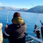
Crowd & Recreation Warning: As the weather warms, the recreational tubing hatch begins. Deckers is a highly popular destination for weekend floaters. To avoid the chaos, plan to be on the water at first light, or focus your efforts on the late evening bite when the recreational crowd has packed up and gone home.
Species Intel
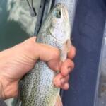
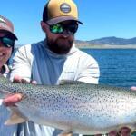
Primary Target: The Deckers corridor is a world-class trout fishery boasting upwards of 3,000 fish per mile. Your primary targets are wild Brown Trout and heavily shouldered Rainbow Trout. Right now, these fish are feeding aggressively. The rainbows tend to stack up in the faster, oxygenated riffles to intercept drifting nymphs, while the cunning brown trout often tuck themselves tightly against the undercut grass banks and behind large boulder structures waiting to ambush a larger meal.
Sleeper Pick: Cutbows and pure-strain Cutthroat Trout. While they make up a smaller percentage of the biomass, these beautiful hybrids and native-strain fish occasionally wash down from Cheesman Canyon. They often hold in the softer, velvet-smooth transition water just off the main current seams. Targeting these specific micro-habitats can yield a stunning, vibrantly colored surprise.
Forage & Baitfish Report: Deckers is a pure insect-driven ecosystem. There are very few baitfish present, so leave the heavy streamers at home unless you are fishing at first light or dusk under heavy cloud cover. The trout are intensely focused on a prolific aquatic insect menu. Caddisflies are the dominant protein source right now, supplemented by daily emergences of Pale Morning Duns (PMDs), Blue-Winged Olives (BWOs), and midges. After a heavy rain, aquatic worms, cranefly larvae, and freshwater scuds get washed into the drift, providing a high-calorie feast.
Tactical Strategy
Where to Target
The fish have officially transitioned out of the deep, slow wintering pools and are now holding in summer lies. Focus your efforts on the transition zones—riffles, gravel shelves, current seams, and the soft tailouts of deeper runs. Excellent water can be found from the Bridge Crossing day-use area down through the Trumbull corridor and extending to the lower boundary of the Tee Pee Club. Look for foam lines; where there is foam, there is food, and where there is food, there are feeding trout.
Attractors: Size 12-14 Pink or Red San Juan Worm (excellent after afternoon rain showers).
Color Patterns & Rigging
Matching the Hatch
Match the natural drift. Olive, bright green, and tan are essential for imitating the current caddis pupae. For the PMDs, pale yellow and light brown are key. If you are fishing a dropper in off-color water following a storm, tie on a bright pink or red worm pattern to grab their attention through the turbidity.
Terminal Tackle
Note: Traditional bait is strictly prohibited on this stretch. A standard two-fly nymph rig under a small, sensitive New Zealand yarn indicator is highly effective. Alternatively, a tight-line Euro nymphing setup is deadly in the pocket water and riffles. Deckers trout are heavily pressured and highly educated, so your terminal tackle must be flawless. Use 5X fluorocarbon tippet for your lead fly and step down to 6X fluorocarbon for your trailing dropper. Space your flies about 12 to 18 inches apart.
Timing the Bite
Arrive at dawn to capitalize on a subtle midge hatch and to fish in solitude. The PMD hatch typically kicks off in the late morning and runs through the early afternoon. As the sun dips behind the canyon walls in the evening, the caddis will return to the water to lay their eggs, sparking explosive, aggressive surface takes that offer the absolute best dry fly fishing of the day.
Pro Tip:When nymphing the shallow summer riffles, micro-adjust your weight. A heavy split shot will cause your rig to drag unnaturally and constantly snag on the bottom. Use just enough weight—perhaps a single size 6 or 4 split shot—to allow your flies to glide naturally through the strike zone.
Pro Tip:If you spot a trout consistently rising but it refuses your high-floating dry fly, it is likely feeding on emergers trapped in the surface film. Tie an unweighted size 20 RS2 onto a 12-inch piece of 6X tippet off the bend of your dry fly. The dry fly will act as a strike indicator for the subtle emerger take.
Regulations Snapshot
The Deckers stretch of the South Platte River is a highly regulated, special management water. Colorado Parks and Wildlife strictly enforces these rules to maintain the world-class quality of the fishery.
Regulation Category
Specific Rule Details
Tackle Restrictions
Fishing is restricted to artificial flies and lures ONLY. Absolutely no organic bait, scented baits, or powerbait of any kind are permitted.
Bag & Size Limits
The daily bag and possession limit is two (2) trout, and both fish must be 16 inches or longer. Any fish under 16 inches must be returned to the water immediately.
Conservation Ethics
While the law allows keeping two large fish, local guides and conservationists strongly encourage 100% catch and release to preserve the trophy genetics of this heavily pressured river.
Regional Alternative
If you arrive at Deckers and find the parking lots overflowing with tubers and fellow anglers, or if a localized storm blows out the river, you need a solid backup plan. Your best immediate alternative is to drive just upstream and hike into Cheesman Canyon.
Access to Cheesman Canyon requires a strenuous hike via the Gill Trailhead, which naturally filters out the casual crowds and river floaters. The Canyon offers a breathtaking landscape of massive granite boulders, deep plunge pools, and technical pocket water. Be warned: the trout in Cheesman Canyon are considered some of the most educated and difficult to catch in North America. You will need to drop down to 6X or 7X tippet, use micro-flies (size 20-24 Baetis and midges), and execute absolutely flawless, drag-free drifts. The reward, however, is unparalleled solitude and the legitimate chance at hooking a tailwater giant.
If you prefer to avoid the technical demands of Cheesman, take a scenic drive over to the North Fork of the South Platte River near the town of Bailey. This smaller, freestone-style fishery receives far less pressure than Deckers and is an excellent place to fish large, buoyant dry-dropper rigs (like a Foam Hopper trailing a Beadhead Pheasant Tail) for eager, opportunistic brown and rainbow trout.
Pro Tip:When venturing into Cheesman Canyon, blind casting is often a waste of time. Treat it like a hunting expedition. Use polarized glasses to spot feeding fish, study their side-to-side movements to determine their feeding lane, and present your fly exactly where they are looking.
Tight lines!
Editor's Choice: Must-Have Gear
FISHINGSIR Next-Gen Waterproof Chest Waders
★★★★★4.4 (7,370+ reviews)
2-Ply Tech: Upgraded nylon with 2.5x higher density than standard fabrics.
100% Waterproof: Lab-approved intrusion resistance with taped visible seams.
Ultra-Lightweight: Designed for all-day comfort while hunting or fishing.
As an Amazon Associate I earn from qualifying purchases. #ad
Loading forecast...
Live Fishing Conditions: Tides, Weather & Waves
Get real‑time tides, marine weather, swell and solunar activity for each spot so you know exactly when conditions line up for your best chance at a bite.
🎣
Deckers
Loading coordinates...
🌤️
WEATHER CONDITIONS
--°F
--°C
Loading...
🌡️
Feels Like--°F--°C
💧
Humidity--%
💨
Wind-- mph-- km/h
🧭
Direction--
📊
Pressure-- inHg-- hPa
☀️
UV Index--
🌊
MARINE CONDITIONS
🌊Wave Height
-- ft
-- m
Loading...
🧭Wave Direction
--°
Loading...
⏱️Wave Period
-- s
Loading...
📈Tide Status
-- ft
-- m
Loading...
🌙
LUNAR & SOLUNAR
🌕
Loading...
Illumination: --%
Major Period--:-- - --:----:-- - --:--
Minor Period--:-- - --:----:-- - --:--
🌅Sunrise--:--
🌇Sunset--:--
📅
24-HOUR FORECAST
Loading fishing conditions...
Fishing Spots Map
🎣
Book a Fishing Charter near Deckers Fishing Report Today 🎣
Local guides & charters. Verified captains, instant booking, best price guaranteed.
There was an error loading the map. Please try refreshing the page.
Info
Local Access & Facilities
The Deckers Fishery: A South Platte Icon
The stretch of the South Platte River flowing through Deckers, Colorado, represents one of the most technically demanding and historically significant trout fisheries in the American West. Situated at the convergence of the North Fork and the main stem of the South Platte, this area is a "Gold Medal" water destination that draws serious anglers from across the globe. The landscape is defined by the rugged, red-granite outcrops of the Pike National Forest and the towering Ponderosa pines that line the riverbanks. For the expert angler, Deckers offers a complex puzzle of currents, deep pools, and highly pressured fish that require precision presentations and intimate knowledge of the aquatic insect life.
Unlike the manicured tailwaters found elsewhere, the river corridor here retains a raw, canyon atmosphere despite its popularity. The water flows clear and cold from the bottom-release Cheesman Dam upstream, creating a year-round fishery that remains productive even when high-country streams are locked in ice. The bottom topography varies from freestone-style riffles to deep, slow-moving runs that hold trophy Rainbow and Brown Trout. This is not a location for the casual caster; the trout here have seen every fly pattern in the book, making success a true badge of honor for seasoned captains and guides.
The atmosphere in Deckers itself is a blend of historic charm and focused angling intensity. The area, originally settled by Stephen Decker in the 1890s as a general store and saloon, maintains its status as a social hub for those coming off the water. While the river is the primary draw, the surrounding wilderness offers a backdrop of spectacular geologic formations, including views of Pikes Peak in the distance. For the boat captain or wading pro, understanding the nuances of access, particularly the balance between public easements and private property, is the first step to unlocking this legendary water.
💡 Captain's Tip: The "Tuber Hatch" Contingency
During summer months, the river sees heavy recreational use from tubers and kayakers starting around 10:00 AM. Seasoned anglers plan their "dawn patrol" to be on the water by first light to fish the trico spinner falls before the flotilla arrives. Alternatively, waiting until late evening often yields the best dry fly action after the crowds have dispersed.
Access & Getting There
Reaching the Deckers corridor requires navigating winding mountain roads that can be deceptive depending on the season. The primary route from the Denver metro area involves taking Highway 285 southwest to Pine Junction, then turning south on Jefferson County Road 126. This 28-mile stretch drops significantly in elevation, offering sweeping views of the valley floor. Drivers should be vigilant for wildlife, particularly mule deer and elk, which frequently cross the tarmac at dawn and dusk. In winter, this route can become treacherous with black ice, so 4WD is recommended for any off-season expeditions.
Upon arrival, parking logistics become a critical strategic element. The Lone Rock Campground area serves as a central hub for river access. The roads and parking aprons here are paved, but capacity is finite. On weekends, the lots fill rapidly. Anglers towing drift boats or rafts need to be particularly conscious of their footprint; while the ramps are generally accessible, maneuvering a trailer in tight, crowded lots requires patience. The boat access here is primarily for small craft, kayaks, and tubers, as the river's character is better suited for wading in many stretches.
For those looking to explore beyond the immediate bridge area, the Gill Trail offers foot access into the more remote Cheesman Canyon. The trailhead is located near the campground and extends 7 miles southwest toward the dam. This is hiking-access only, requiring anglers to pack in their gear. The effort is often rewarded with less pressured water and solitude that is hard to find near the road. Additionally, the Log Jumper Trailhead, located approximately 5.8 miles from the main hub, provides alternative parking for those willing to hike to different river sections.
💡 Captain's Tip: Winter Road Realities
The road down from Pine Junction is steep and shaded. Even if it is sunny in Denver, the corners on Hwy 126 often hold ice well into the afternoon. Ensure your vehicle has appropriate tires and carry chains if towing a drift boat trailer during the shoulder seasons.
Deckers Pre-Trip Checklist
Facilities & Amenities
The infrastructure in Deckers is purpose-built for the outdoor enthusiast, but it lacks the amenities of a full-service marina town. The epicenter of local angling intelligence is Flies & Lies, a bait and tackle shop located directly in the hamlet, a mere 75 feet from the central reference point. This shop is not just a retail space; it is the repository of daily river flows, hatch reports, and gear adjustments. They open at 8:00 AM, which is sufficient for grabbing last-minute tippet, but serious pros usually have their boxes sorted the night before. For more extensive outfitting or heavy gear needs, South Platte Fly Shop in Woodland Park (20.6 miles away) or Ken's Anglers in Littleton (23.6 miles away) are the nearest major outfitters.
Regarding lodging and basecamp operations, Lone Rock Campground is the primary facility directly on the water. It sits at an elevation of 6,479 feet and offers basic amenities including two vault toilets and a community drinking water hydrant. It is critical to note that there are no RV hookups or sewer services here. The sites are paved and can accommodate vehicles up to roughly 35-40 feet depending on the specific site, but it is essentially dry camping. Firewood is available for sale, and trash collection is provided, but self-reliance is the rule. For a more upscale experience or client lodging, Lost Valley Ranch is located about 7.9 miles away, offering a distinct step up in comfort.
Fuel and provisions are another logistical consideration. While there is a general store history in Deckers, grocery availability is limited to basics. Captains should advise clients to stock up on substantial provisions in Sedalia or Woodland Park before descending into the canyon. There is no marina-style fuel dock on the river; all vessels must be fueled prior to launch, and carrying reserve jerry cans is unnecessary for river floats but good practice for tow vehicles given the distance to the nearest gas station.
Facility Name
Type
Distance
Notes
Flies & Lies
Tackle Shop
75 ft
Local hub, opens 8 AM.
Lone Rock Campground
Camping/Access
0.4 miles
Vault toilets, no hookups, river views.
Chatfield Lake
Rec Area/Launch
22.9 miles
Full marina services for larger vessels.
Lost Valley Ranch
Lodging
7.9 miles
Upscale guest ranch accommodation.
Pulver Mountain Group Site
Camping
20.5 miles
Group facilities, pavilion, vault toilets.
Permits, Regulations & Fees
Fishing the South Platte River corridor places anglers under the jurisdiction of the Pike National Forest and state wildlife agencies. Strict regulations are enforced to maintain the "Gold Medal" status of the water. While specific bag limits and tackle restrictions (such as flies-only or barbless hook requirements) should be verified immediately prior to fishing via the interactive map below or local signage, the general ethos here is catch-and-release conservation. The pressure on this fishery is immense, and the regulations are designed to sustain the population of wild Rainbow and Brown Trout.
Lone Rock Campground and other developed recreation sites operate under the Federal Recreation Lands Enhancement Act. Day-use fees are typically required for parking at improved lots like the Bridge Crossing Picnic Area. If you are camping, a reservation is highly recommended, especially for weekends. Cancellations and no-shows incur fees, and the reservation window is competitive. The Pulver Mountain Group Site offers a private area with a pavilion for larger parties or organized trips, but it requires advance booking and has a locked gate for privacy.
Anglers must also respect private property boundaries. The river corridor is a patchwork of National Forest land and private holdings. In Colorado, the stream bed is often considered private property if it flows through private land, meaning wading can constitute trespassing. Always stay within the high-water mark in public zones and utilize designated access points like the Scraggy View or Bridge Crossing picnic areas to avoid conflict. Respecting "Kapu" (forbidden/sacred) concepts of stewardship and land ownership is vital for maintaining angler access in the future.
💡 Captain's Tip: Technical Rigging
The trout in the clear waters near the bridge are notoriously line-shy. Pros typically size down to 5x or 6x fluorocarbon tippet and use strike indicators that land softly, such as yarn or New Zealand wool, rather than heavy plastic bobbers that spook fish in the slow pools.
Events & Seasonal Information
The South Platte at Deckers is a true four-season fishery, but the rhythms of the river dictate the strategy. Spring and Fall are the premier angling seasons, offering the best balance of hatch activity (Blue Winged Olives and Midges) and manageable water temperatures. Summer brings the "recreational hatch" of non-anglers, which changes the dynamic of the water significantly during midday hours. The water remains ice-free near the dam release in winter, providing a sanctuary for anglers willing to brave the cold for technical midge fishing.
While specific tournament schedules vary, the corridor is a frequent host for conservation events and river cleanups organized by local chapters of Trout Unlimited. The South Platte River Corridor has a rich history as a resort destination dating back to the early 1900s, and that legacy continues with high visitation during holidays. Anglers should anticipate peak traffic on Memorial Day, July 4th, and Labor Day. During these windows, the Lone Rock and Bridge Crossing areas will be at maximum capacity by mid-morning.
Weather patterns in this canyon can shift rapidly. Thunderstorms build quickly over the Rampart Range in the summer afternoons. The granite canyon walls amplify the sound of thunder, and lightning is a serious hazard for those holding graphite rods. It is advisable to be off the water or near shelter when the dark clouds crest the ridge line. Conversely, winter days can be surprisingly mild, but once the sun drops behind the canyon rim, temperatures plummet instantly.
Contact Information & Resources
For official information regarding campsite availability, road closures, and fire restrictions, the Pike National Forest, South Platte Ranger District is the primary authority. They can be reached regarding facility-specific queries at 303-275-5610. For inquiries specifically related to the Lone Rock Campground, the direct line is 303-647-2366. In the event of an emergency, cell service is spotty and unreliable within the deep granite canyons. A satellite messenger or travel to the high ground near Pine Junction or Woodland Park may be necessary to reach 911 services.
For visitors interested in the broader natural history of the region, the Florissant Fossil Beds National Monument is located approximately 23.8 miles away (Phone: 719-748-3253). This site offers a fascinating geological context to the prehistoric landscape you are fishing in. Always inform a shore contact of your float plan or hiking itinerary before descending into the river corridor.
For precise locations of the best wading entry points, real-time river flow data, and the location of the nearest fly shop, consult the live dashboard and interactive maps below.
🎣
Deckers
Sedalia • Colorado • 39.2542, -105.2269
🅿️
Parking
5
Log Jumper(677) Trailhead
⭐ 5.05.8 mi
📍7501-7917 S Rampart Range Rd, Sedalia, CO 80135, USA
Our spot reports combine data-driven forecasts with curated local information. The forecast is generated by our proprietary Fishing Score algorithm (0–100%), which analyzes real-time data from Open-Meteo API, validated against NOAA CO-OPS tide gauges and USGS water-monitoring stations. The model weights tide dynamics (35%), wave energy (25%), wind patterns (20%) and time of day (20%)—factors shown to influence fish feeding behavior through marine-biology research and decades of charter log data.
Access, facilities and services information for each fishing spot is sourced from official datasets such as Recreation.gov (RIDB), state park & wildlife agencies, and geospatial providers like Google Maps. These sections undergo scheduled re-validation every 3–6 months to ensure that boat ramps, park access, contact details and local services remain accurate.
Narrative sections (catches, seasonal behavior, local tips) are synthesized from these data sources and refined following the Fishing Reports Today editorial guidelines, combining bibliographic research from ichthyology and oceanography with expert angler experience. Our team reviews reports on a regular basis, while the forecast model itself updates every 6 hours for real-time accuracy.
⚠️ Important: Always verify current local regulations, access restrictions and weather conditions before fishing. These reports are intended as a planning aid, not a guarantee of catches or safety. When in doubt, contact local authorities or park managers listed on the page.
To provide the best experiences, we use technologies like cookies to store and/or access device information. Consenting to these technologies will allow us to process data such as browsing behavior or unique IDs on this site. Not consenting or withdrawing consent, may adversely affect certain features and functions.
Functional Always active
The technical storage or access is strictly necessary for the legitimate purpose of enabling the use of a specific service explicitly requested by the subscriber or user, or for the sole purpose of carrying out the transmission of a communication over an electronic communications network.
Preferences
The technical storage or access is necessary for the legitimate purpose of storing preferences that are not requested by the subscriber or user.
Statistics
The technical storage or access that is used exclusively for statistical purposes.The technical storage or access that is used exclusively for anonymous statistical purposes. Without a subpoena, voluntary compliance on the part of your Internet Service Provider, or additional records from a third party, information stored or retrieved for this purpose alone cannot usually be used to identify you.
Marketing & Affiliates
The technical storage or access is required to create user profiles to send advertising, or to track the user on a website or across several websites for similar marketing purposes, including affiliate tracking for products recommended in our reports.


Leave a Reply