Welcome to the classic Florida summer fishing pattern on the Space Coast. The current assessment is a resounding GO for anglers who are willing to set their alarms and launch in the dark. However, a strict CAUTION applies as the day progresses into the afternoon. Water temperatures have climbed into the mid-to-high 80s, which pushes our local gamefish into a predictable, yet highly condensed, early feeding window. You must capitalize on the low-light hours.
Safety is a primary concern during the summer months. The morning hours generally offer slick-calm conditions on the Atlantic and glassy water in the Banana River Lagoon. By 1:00 PM to 2:00 PM, the daily thermal sea breeze builds, inevitably triggering volatile, fast-moving thunderstorms. Lightning is a severe hazard on the open flats and nearshore waters. Plan to be on the water by 5:30 AM and safely back at the boat ramp or dock by early afternoon.
From the editor
Tired of fishing with strangers you can’t trust?
Nautrek is the first social network for serious anglers — verified partners, real trips, cost splitting and intel sharing without burning your spots. Private beta now open.
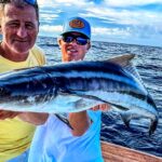
Summer is the undisputed season of the Silver King. Massive migratory Tarpon in the 100 to 150-pound class are actively rolling just beyond the breakers along the beaches. These prehistoric leviathans are following the massive bait migrations and offer world-class big-game action within sight of the shoreline.
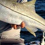
Inshore, Snook are the main event. While many large breeder Snook have moved toward Port Canaveral and the coastal inlets for their summer spawn, the mangrove shorelines and deeper residential canals of the Banana River are still holding excellent numbers of aggressive, slot-sized fish seeking shade and ambush points.
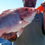
Sleeper Pick: Mangrove Snapper
While the majority of anglers are burning fuel looking for offshore pelagics or poling the sweltering flats for glamour species, the Mangrove Snapper bite is highly overlooked. These structure-oriented fish are holding tight to the dock pilings, bridge fenders, and the cruise ship terminal bulkheads in Port Canaveral. They provide incredibly consistent action, put up a frantic fight on light tackle, and offer some of the best table fare on the coast.
Baitfish Report
The nearshore waters are currently thick with tightly packed pods of Pogies (Atlantic Menhaden). You will easily spot them flipping on the surface or see pelicans dive-bombing them just past the surf zone. Inshore, schools of finger mullet are actively pushing up the river systems, and small pinfish are blanketing the seagrass beds. Match your lure profiles and live bait selections to these abundant forage species.
TACTICAL STRATEGY
Inshore Flats and Mangroves (Banana River & Thousand Islands)
Where: Target the mangrove shorelines and the 2 to 4-foot sandy potholes scattered throughout the seagrass beds in the Thousand Islands area. Focus your efforts on the eastern shorelines at dawn to take advantage of the longest periods of morning shade. The fish will push deeper into the mangrove roots as the sun rises.
Lure: Tie on a 1/4-ounce tungsten jighead paired with a 3-inch paddletail swimbait. If you are fishing the first hour of daylight, a noisy topwater walker like a Zara Spook is absolutely deadly for drawing explosive reaction strikes from Snook and Spotted Seatrout.
Color: Pearl white or chartreuse are the top producers for soft plastics in the slightly tannin-stained lagoon water. Use bone or chrome finishes for your topwater plugs.
Bait: Free-lined live shrimp or small finger mullet hooked through the lips. Skip them as far back under the mangrove overhangs as possible.
Timing: The bite window is incredibly tight. First light until about 9:30 AM is your prime time. Once the sun is high and the water heats up, the bite shuts down dramatically.
Pro Tip: When skipping soft plastics or live bait under the overhanging mangroves for Snook, upgrade your fluorocarbon leader to 30lb or even 40lb test. Summer Snook hit with ferocious power and will instantly wrap you around the nearest barnacle-encrusted root system if you give them a single inch of slack. Lock down your drag and turn their head immediately.
Nearshore Beach Fishing (Cocoa Beach Pier to Patrick Space Force Base)
Where: Cruise just outside the surf zone, heading south from the Cocoa Beach Pier toward Patrick Space Force Base. You are hunting for diving birds, nervous water, or massive dark clouds of bait on your sonar in 15 to 30 feet of water.
Lure/Bait: Live Pogies are the absolute best offering for giant Tarpon and cruising King Mackerel. Catch them with a heavy cast net, then hook a lively bait through the bottom lip and out the nose with an 8/0 to 9/0 inline circle hook. Use a 60lb to 80lb fluorocarbon leader to withstand the abrasive jaws of a Tarpon.
Timing: Outgoing tides that flush warmer, nutrient-rich river water out of the port and into the ocean often trigger aggressive feeding frenzies along the nearshore color changes.
Pro Tip: When setting up on a nearshore bait pod, do not plow your boat right through the middle of the school. Skirt the outside edges with your trolling motor and pitch your baits to the fringes. The apex predators do not sit inside the bait pod; they patrol the perimeter, actively corralling the baitfish and picking off the weak.
REGULATIONS SNAPSHOT
Summer fishing in Florida requires strict adherence to conservation rules to protect our breeding stock. Always verify with the Florida Fish and Wildlife Conservation Commission (FWC) before your trip, but here is your current baseline for the Cocoa Beach and Space Coast region:
Target Species
Season Status
Key Regulations & Limits
Snook
CLOSED (Summer Spawning)
Strictly Catch and Release only during the summer months. Handle with extreme care, keep them in the water, and revive them fully before release.
Tarpon
Catch & Release Only
Harvest is strictly prohibited. Any Tarpon over 40 inches MUST remain in the water at all times to ensure survival.
Spotted Seatrout
OPEN
Slot limit is 15 to 19 inches. Anglers are allowed a small daily bag limit (typically 2 per harvester in this specific zone), with one fish allowed over 19 inches per vessel.
Mangrove Snapper
OPEN
Minimum size limit is 10 inches. The daily bag limit is 5 per person per day.
REGIONAL ALTERNATIVE
If the Banana River is choked with floating summer seagrass or the Atlantic beaches are blown out from a lingering tropical weather system, pack up your gear and head an hour south to Sebastian Inlet State Park.
Access & Setup: Sebastian Inlet provides deep, fast-moving water that aggressively flushes out the entire lagoon system, acting as a massive bottleneck for bait and predators. You can fish from the extensive north or south rock jetties, or launch a vessel to drift the main channel.
Target Species: Bull Redfish, monster Snook, and aggressive Jack Crevalle.
Tactical Approach: The water moves incredibly fast here, so finesse lagoon tactics go out the window. If you are fishing the jetties, throw heavy 1.5 to 2-ounce flair hawk jigs straight into the current. Let the jig sink completely to the bottom before beginning a steady, bouncing retrieve back to the rocks. If drifting by boat, drop live croakers or pigfish on a heavy three-way rig to keep your bait pinned in the strike zone near the bottom structure.
Pro Tip: The Sebastian Inlet tide pool located on the north side of the park is a fantastic, sheltered area. If the main channel is too rough, use this protected cove to catch your own live bait, or let younger anglers fish for smaller snapper and sheepshead away from the treacherous main currents.
Tight lines!
Editor's Choice: Must-Have Gear
FISHINGSIR Next-Gen Waterproof Chest Waders
★★★★★4.4 (7,370+ reviews)
2-Ply Tech: Upgraded nylon with 2.5x higher density than standard fabrics.
100% Waterproof: Lab-approved intrusion resistance with taped visible seams.
Ultra-Lightweight: Designed for all-day comfort while hunting or fishing.
As an Amazon Associate I earn from qualifying purchases. #ad
Loading forecast...
Live Fishing Conditions: Tides, Weather & Waves
Get real‑time tides, marine weather, swell and solunar activity for each spot so you know exactly when conditions line up for your best chance at a bite.
🎣
Cocoa Beach
Loading coordinates...
🌤️
WEATHER CONDITIONS
--°F
--°C
Loading...
🌡️
Feels Like--°F--°C
💧
Humidity--%
💨
Wind-- mph-- km/h
🧭
Direction--
📊
Pressure-- inHg-- hPa
☀️
UV Index--
🌊
MARINE CONDITIONS
🌊Wave Height
-- ft
-- m
Loading...
🧭Wave Direction
--°
Loading...
⏱️Wave Period
-- s
Loading...
📈Tide Status
-- ft
-- m
Loading...
🌙
LUNAR & SOLUNAR
🌕
Loading...
Illumination: --%
Major Period--:-- - --:----:-- - --:--
Minor Period--:-- - --:----:-- - --:--
🌅Sunrise--:--
🌇Sunset--:--
📅
24-HOUR FORECAST
Loading fishing conditions...
Fishing Spots Map
🎣
Book a Fishing Charter near Cocoa Beach Fishing Report Today 🎣
Local guides & charters. Verified captains, instant booking, best price guaranteed.
There was an error loading the map. Please try refreshing the page.
Info
Local Access & Facilities
Cocoa Beach and the surrounding Merritt Island area represent a unique intersection where pristine estuarine wilderness meets the high-tech legacy of the Space Coast. For the serious angler, this location offers more than just a place to wet a line; it is a gateway to the Merritt Island National Wildlife Refuge, a massive expanse of habitat that has been federally protected since the dawn of the Kennedy Space Center. The atmosphere here shifts rapidly from the surf-town energy of the beach itself to the quiet, rugged isolation of the refuge waters.
The fishery is defined by its diverse access points, ranging from manicured causeways to remote refuge shorelines. While the Atlantic surf provides its own challenges, the real draw for many technical anglers is the access to the protected backwaters managed by the U.S. Fish and Wildlife Service. Navigating this area requires an understanding of the delicate balance between public recreation zones and strict conservation closures designed to protect species like the Eastern Black Rail and Wood Stork.
Accessing these waters requires a strategic approach to traffic and timing, particularly when launches coincide with space industry activity or peak tourist seasons. The infrastructure here is robust, supporting a heavy boating culture, but the vastness of the area means that knowing exactly where to launch and where to fuel up can save hours of transit time. This guide breaks down the logistical realities of fishing the Space Coast, ensuring you spend less time on the pavement and more time on the water.
Access & Getting There
Reaching the prime fishing grounds around Cocoa Beach and Merritt Island typically involves navigating from I-95. The primary artery for anglers heading toward the refuge waters is Exit 220 (State Road 406/Garden Street) in Titusville. From here, you will drive east for approximately four miles, crossing the Max Brewer Causeway Bridge. This route is the main vein into the northern sectors of the fishery and offers a dramatic transition from city streets to open water. Traffic on Garden Street is generally manageable, but congestion can spike during launch windows or heavy beach weekends.
For boaters trailing vessels, the launch situation is varied. The area features several boat access points, including the main facilities within the Merritt Island National Wildlife Refuge. While the refuge ramps are generally well-maintained, early arrival is standard procedure for locals, especially on calm-weather weekends. The ramps here place you directly into the habitat, minimizing idle times. If you are launching closer to the city center or the port, be aware that commercial traffic near Port Canaveral can create significant wakes and bottlenecks.
💡 Captain's Tip: Dawn Patrol Logistics
If you are planning a pre-dawn launch, note that many local bait shops do not open until 9:00 AM. However, Space Coast Bait & Tackle (Captain Hooks) in Titusville opens at 5:00 AM, making it the critical stop for early risers needing live bait before hitting the refuge ramps.
Parking for vehicles and trailers requires foresight in this region. AirGarage on North Orlando Avenue offers 24-hour public parking, which is a vital resource for surf casters looking to hit the beach before sunrise. For those with larger rigs or needing overflow options, Lots of Honor and Park N Cruise on Sea Ray Drive provide alternatives, though they are often geared toward cruise traffic. Always verify trailer permitting at private lots, as enforcement is strict near the coast.
Weather dictates access significantly in this barrier island environment. The causeways and open basins are exposed to wind. When trade winds exceed 15 knots, the open waters of the lagoon can chop up quickly, making small skiff crossings wet and uncomfortable. In high wind scenarios, seasoned skippers stick to the leeward shorelines of the spoil islands or the protected cuts within the refuge. Always monitor the specific wind direction relative to your launch ramp to ensure you can retrieve the boat safely without fighting a crosswind pinned against the dock.
Cocoa Beach Pre-Trip Checklist
Facilities & Amenities
The local infrastructure for anglers is divided between general tourist amenities and specialized pro shops. For tackle and bait, the options vary heavily by location and opening hours. Cocoa Beach Bait & Tackle Rentals is a convenient hub located just 2 miles from the central spot on the Merritt Island Causeway. They handle the basics and are well-positioned for anglers fishing the central bridges. However, their 9:00 AM opening time makes them less suitable for the dawn patrol crowd.
For heavy-duty offshore gear or serious charter connections, Cocoa Beach Fishing Center near Cape Canaveral is a staple. They are located closer to the inlet and cater to the big game crowd. If you are looking for spear-fishing intel or specialized inshore advice, the local network is strong. Space Coast Bait & Tackle (Captain Hooks) serves as the primary intelligence hub for the northern end of the fishery. Their early hours and proximity to the refuge make them the de facto headquarters for serious inshore captains.
Facility Name
Type
Distance
Captain's Notes
Space Coast Bait & Tackle (Captain Hooks)
Tackle Shop
21.9 mi
Opens 5:00 AM. Best for early bait.
Cocoa Beach Bait & Tackle
Tackle Shop
2.0 mi
Closer to town. Opens 9:00 AM.
Cocoa Beach Fishing Center
Bait/Charter
4.8 mi
Located near Port. Opens 6:00 AM.
AirGarage (Java Beach)
Parking
3.4 mi
Open 24 Hours. Good for surf access.
Accommodations for the traveling angler are available but require careful selection based on boat parking needs. Moose Lodge Campground offers proximity to the water, roughly 6.4 miles from the center. For those looking for more resort-style amenities, Outdoor Resorts in Melbourne Beach is a high-quality option, though it sits about 21 miles south, requiring a longer morning tow. Wickham Park also provides camping facilities roughly 11 miles away, offering a wooded respite from the coastal sun.
The charter fleet in this region is world-class, split between inshore specialists and offshore heavy hitters. Fin & Fly Fishing Charters and Southern Mayhem Fishing Charters operate directly out of Cocoa Beach, providing easy access for visitors staying on the island. For those targeting the specific ecology of the Cape, Fired Up Fishing Charters is based just 6 miles away in Cape Canaveral. These operators are essential resources for understanding the seasonal movements of fish through the locks and passes.
💡 Local Alert: Missing Amenities
Be advised that the remote boat ramps within the Merritt Island National Wildlife Refuge often lack freshwater washdowns and fish cleaning stations. Anglers should bring their own ice and plan to clean their catch and flush their engines back at home or at a full-service marina.
Permits, Regulations & Fees
Fishing in this region is governed by a complex overlay of state and federal regulations due to the presence of National Wildlife Refuges and NASA security zones. The Merritt Island National Wildlife Refuge allows boating and fishing, but it is strictly managed to protect wildlife. A standard Florida saltwater fishing license is required, but anglers must also be vigilant about specific refuge rules, which may restrict speed, access hours, or entry into specific zones depending on rocket launch schedules.
A critical piece of "negative knowledge" for anglers exploring the map is the status of the St. Johns National Wildlife Refuge. Located approximately 21 miles west, this area is managed by the staff at Merritt Island but is closed to the public. There is no recreational fishing or public access permitted here. This closure is strictly enforced to protect the habitat of the Eastern Black Rail and other threatened species. Do not attempt to access the water via Highway 50 in this specific refuge zone.
Within the accessible areas of Merritt Island NWR, cultural and environmental respect is paramount. The refuge was established in 1963 and overlays land acquired for the Space Center. You are fishing in a corridor that protects ancient Native American sites and modern aerospace history. "Kapu"—or forbidden/sacred areas—should be respected, whether marked by federal signs or indicated by local knowledge. Conservation is the priority here; catch-and-release is highly encouraged to maintain the world-class status of the fishery.
Events & Seasonal Information
The fishing calendar in Cocoa Beach is driven by the seasonal shifts in water temperature and bait migration. Summer brings calm mornings and the potential for heavy afternoon thunderstorms, a rhythm that locals set their watches by. This is prime time for fishing the beaches and the deeper channels near the port. Winter shifts the focus to the protected backwaters of the refuge, where game fish seek warmth in the shallows and darker mud bottoms.
The area does not host a single massive tournament season but rather a continuous flow of local and regional events, often centered around the port marinas. The "Snowbird" season sees an increase in traffic on the causeways and at the ramps. Anglers should anticipate busier waters from January through April. Conversely, the late summer months, while hot, often offer the most solitude on the water, provided you are off the water before the midday heat peaks.
💡 Captain's Tip: Wind Awareness
The vast, shallow basins of the nearby lagoons are notoriously susceptible to wind chop. A 15-knot wind that is manageable offshore can turn the shallow flats into a dangerous washing machine. Always check the hourly wind forecast before crossing open stretches of the refuge.
Contact Information & Resources
For official information regarding access status, closures, and permits, the primary authority is the Merritt Island National Wildlife Refuge. They can be reached at 321-861-5601. For inquiries regarding the closed St. Johns NWR, the contact number is 321-861-0667. The Visitor Center is located 4 miles past the refuge entrance on SR 406 and is an excellent source for current maps and conditions.
Safety in this area is the angler's responsibility. Cell service can be spotty in the remote northern reaches of the lagoon. Always file a float plan and carry adequate safety gear. For precise locations, real-time weather data, and detailed facility maps, consult the interactive dashboard and widgets below.
Our spot reports combine data-driven forecasts with curated local information. The forecast is generated by our proprietary Fishing Score algorithm (0–100%), which analyzes real-time data from Open-Meteo API, validated against NOAA CO-OPS tide gauges and USGS water-monitoring stations. The model weights tide dynamics (35%), wave energy (25%), wind patterns (20%) and time of day (20%)—factors shown to influence fish feeding behavior through marine-biology research and decades of charter log data.
Access, facilities and services information for each fishing spot is sourced from official datasets such as Recreation.gov (RIDB), state park & wildlife agencies, and geospatial providers like Google Maps. These sections undergo scheduled re-validation every 3–6 months to ensure that boat ramps, park access, contact details and local services remain accurate.
Narrative sections (catches, seasonal behavior, local tips) are synthesized from these data sources and refined following the Fishing Reports Today editorial guidelines, combining bibliographic research from ichthyology and oceanography with expert angler experience. Our team reviews reports on a regular basis, while the forecast model itself updates every 6 hours for real-time accuracy.
⚠️ Important: Always verify current local regulations, access restrictions and weather conditions before fishing. These reports are intended as a planning aid, not a guarantee of catches or safety. When in doubt, contact local authorities or park managers listed on the page.
To provide the best experiences, we use technologies like cookies to store and/or access device information. Consenting to these technologies will allow us to process data such as browsing behavior or unique IDs on this site. Not consenting or withdrawing consent, may adversely affect certain features and functions.
Functional Always active
The technical storage or access is strictly necessary for the legitimate purpose of enabling the use of a specific service explicitly requested by the subscriber or user, or for the sole purpose of carrying out the transmission of a communication over an electronic communications network.
Preferences
The technical storage or access is necessary for the legitimate purpose of storing preferences that are not requested by the subscriber or user.
Statistics
The technical storage or access that is used exclusively for statistical purposes.The technical storage or access that is used exclusively for anonymous statistical purposes. Without a subpoena, voluntary compliance on the part of your Internet Service Provider, or additional records from a third party, information stored or retrieved for this purpose alone cannot usually be used to identify you.
Marketing & Affiliates
The technical storage or access is required to create user profiles to send advertising, or to track the user on a website or across several websites for similar marketing purposes, including affiliate tracking for products recommended in our reports.


Leave a Reply