Verdict: GO (with CAUTION for nearshore/offshore small craft)
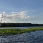
Current seasonal transitions are ushering in classic summer patterns across Northeast Florida. The estuaries, tidal creeks, and nearshore waters around Amelia Island are teeming with life as water temperatures climb into the upper 70s and low 80s. Inshore anglers have a solid green light to chase tailing reds and aggressive seatrout deep in the backcountry. However, small craft operators heading out the St. Marys or Nassau inlets should exercise caution. While morning conditions are generally pristine and highly favorable, predictable afternoon thermal breezes—often pushing 10 to 15 knots out of the south or southwest—combined with pop-up thunderstorms can make the inlets treacherous. This is especially true during an outgoing tide stacking up against an incoming ocean swell. Plan your trips early to beat the heat, maximize the morning bite, and safely navigate the weather windows.
2. SPECIES INTEL
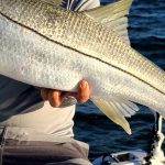
Primary Target: Redfish (Red Drum)
Redfish are currently dominating the inshore catch reports and are the undisputed kings of the summer flats. As the bait pushes into the shallow estuaries, these bronze bruisers are aggressively feeding on the flooded spartina grass flats during high flood tides. You will find them pushing wakes and waving their spotted tails as they root for fiddler crabs and crustaceans in inches of water. When the tide falls, they consolidate in the deeper creek holes and oyster-lined run-outs.
From the editor
Tired of fishing with strangers you can’t trust?
Nautrek is the first social network for serious anglers — verified partners, real trips, cost splitting and intel sharing without burning your spots. Private beta now open.
While many anglers are fixated on completing their inshore slam or running 50 miles offshore for bottom fish, the nearshore Cobia bite is a massive sleeper right now. These curious, hard-fighting fish are cruising just off the beaches, inlet mouths, and nearshore wrecks. They are migrating up the coast following the warming water and abundant bait. Keep a heavy-tackle pitch bait ready at all times, as they will often pop up right next to your boat, trail behind migrating manta rays, or shadow large sea turtles.
Baitfish Report
The forage base is extremely healthy and diverse right now, which is turning on the predatory feed. Massive pods of menhaden (pogies) are running along the beaches and just outside the breakers. Inside the marshes and creeks, you will find an abundance of finger mullet, glass minnows, and small blue crabs. Matching the hatch with these specific bait profiles—both in size and swimming action—is the key to triggering a bite from heavily pressured fish.
3. TACTICAL STRATEGY
Where to Find Them
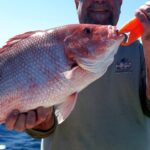
For Redfish, focus your efforts on the vast spartina marshes and bays located just south of the Shave Bridge (A1A) and the labyrinth of creeks behind Tiger Island. The key is to access these shallow mud flats during the last hour of the flooding tide. For Spotted Seatrout, target the deep sides of the marsh banks and submerged oyster bars along the Amelia River and Egan's Creek, particularly where clean saltwater flushes over the structure during the incoming tide. If you are after Flounder or a mixed bag of drum and sheepshead, the St. Marys Jetty rocks are holding excellent numbers of fish along the deep, submerged granite edges.
Lure & Bait Selection
Artificials: For redfish in the thick grass, a 1/2 oz Johnson Silver Minnow (Gold color) is virtually weedless, casts a mile, and is highly effective. For seatrout and flounder, throw a 1/4 oz lead head jig paired with a 4-inch paddletail or a jerk shad. Early mornings call for walk-the-dog topwater plugs like a Zara Spook over shallow oyster bars.
Colors: In the stained marsh water, lean on high-visibility colors like Chartreuse or Rootbeer with a chartreuse tail. If the water clears up on the top of the incoming tide, switch to natural baitfish profiles like Pearl White, Silver/Blue, or New Penny.
Live Bait: A live mud minnow dragged slowly on a Carolina rig (using a 1/2 oz egg sinker, 20lb fluorocarbon leader, and a 2/0 circle hook) is deadly for flounder around the jetty rocks. For nearshore Cobia or Tarpon, nose-rig a live pogy on a 5/0 circle hook and free-line it into the bait pods.
Timing the Bite
Tide is everything in Northeast Florida's tidal-driven fishery. The most productive window is the last three hours of the incoming tide and the first hour of the falling tide. This period brings cooler, oxygen-rich ocean water into the back bays, stimulating a heavy feed. Early morning high tides coinciding with low light conditions offer the absolute best topwater bite for seatrout and aggressive redfish.
Pro Tip: When fishing the St. Marys jetties for flounder, do not cast parallel to the rocks. Instead, position your boat slightly off the structure, cast right up to the visible rocks, and slowly bump your mud minnow down the underwater slope. Most strikes occur right at the depth transition line where the rocks meet the sandy bottom.
Pro Tip: If you are hunting tailing redfish on the flooded grass flats, stealth is mandatory. Turn off your outboard well before your spot and use a push pole to navigate the shallows. The vibration of a trolling motor prop can spook a flat of shallow-water reds instantly, ruining the bite for hours.
Pro Tip: When targeting Cobia nearshore, always have a 1 oz bucktail jig (chartreuse or white) rigged with a long curly-tail grub on a medium-heavy spinning rod. If a Cobia swims up to the boat to investigate, cast past the fish and retrieve the jig diagonally across its face to trigger a reaction strike.
4. REGULATIONS SNAPSHOT
Be sure to adhere to the Florida Fish and Wildlife Conservation Commission (FWC) regulations for the Northeast Management Region. The FWC has recently updated rules to manage fisheries on a localized level, so ensure you are following the specific Northeast zone mandates:
Species
Slot/Size Limit
Daily Bag Limit
Redfish (Red Drum)
18 to 27 inches
1 per person (Max 4 per vessel)
Spotted Seatrout
15 to 19 inches (No over-slot allowed)
3 per person
Flounder
14-inch minimum
5 per person
Note: Captain and crew are strictly prohibited from retaining a bag limit of Redfish or Seatrout while on a for-hire trip. Always handle catch-and-release fish with wet hands and support their belly to ensure survival.
5. REGIONAL ALTERNATIVE
If stiff coastal winds blow out the inlets and make the exposed waters of Nassau Sound or Cumberland Sound unfishable, head inland to the St. Johns River in Jacksonville. Access the river via the Sisters Creek ramp or Jim King Park. The winding, protected backcountry creeks (like Clapboard Creek or Pumpkin Hill Creek) offer excellent shelter from heavy ocean breezes and choppy conditions.
Here, you can employ the exact same tactics to salvage your day. Pitch live shrimp or mud minnows under popping corks, or work weedless spoons to target resident redfish and black drum holding in the deeper creek bends and around residential docks. The heavy canopy of the inland creeks breaks the wind, providing a glass-calm surface even when the beaches are getting hammered by a stiff southerly blow. Focus on the deep undercut banks where the current sweeps bait past waiting predators.
Tight lines!
Editor's Choice: Must-Have Gear
FISHINGSIR Next-Gen Waterproof Chest Waders
★★★★★4.4 (7,370+ reviews)
2-Ply Tech: Upgraded nylon with 2.5x higher density than standard fabrics.
100% Waterproof: Lab-approved intrusion resistance with taped visible seams.
Ultra-Lightweight: Designed for all-day comfort while hunting or fishing.
As an Amazon Associate I earn from qualifying purchases. #ad
Loading forecast...
Live Fishing Conditions: Tides, Weather & Waves
Get real‑time tides, marine weather, swell and solunar activity for each spot so you know exactly when conditions line up for your best chance at a bite.
🎣
Fernandina Beach
Loading coordinates...
🌤️
WEATHER CONDITIONS
--°F
--°C
Loading...
🌡️
Feels Like--°F--°C
💧
Humidity--%
💨
Wind-- mph-- km/h
🧭
Direction--
📊
Pressure-- inHg-- hPa
☀️
UV Index--
🌊
MARINE CONDITIONS
🌊Wave Height
-- ft
-- m
Loading...
🧭Wave Direction
--°
Loading...
⏱️Wave Period
-- s
Loading...
📈Tide Status
-- ft
-- m
Loading...
🌙
LUNAR & SOLUNAR
🌕
Loading...
Illumination: --%
Major Period--:-- - --:----:-- - --:--
Minor Period--:-- - --:----:-- - --:--
🌅Sunrise--:--
🌇Sunset--:--
📅
24-HOUR FORECAST
Loading fishing conditions...
Fishing Spots Map
🎣
Book a Fishing Charter near Fernandina Beach Fishing Report Today 🎣
Local guides & charters. Verified captains, instant booking, best price guaranteed.
There was an error loading the map. Please try refreshing the page.
Info
Local Access & Facilities
The Strategic Gateway: Fernandina Beach and the Cumberland Sound
Fernandina Beach represents a unique intersection of developed maritime infrastructure and raw, unblemished wilderness. Situated on Amelia Island, it serves as the primary civilized staging ground for anglers targeting the expansive Cumberland Sound and the pristine waters of the Cumberland Island National Seashore just across the state line in Georgia. For the expert angler, this location offers a stark duality: the convenience of a historic harbor town with deep-water access and the logistical challenge of fishing one of the Atlantic Coast's last undeveloped barrier islands. The atmosphere here shifts rapidly from the bustling, manicured docks of the marina district to the silent, moss-draped maritime forests and salt marshes that line the St. Marys River.
The fishery is defined by its diversity of structure, ranging from the deep channels of the St. Marys entrance—where nuclear submarines transit—to the shallow, winding tidal creeks of the Timucuan Ecological & Historic Preserve to the south. Seasoned captains know that this is not merely a "park and fish" destination; it requires an understanding of complex access rules, particularly if you intend to exploit the productive waters surrounding the National Seashore. The bottom topography varies from sandy shoals shifting with the Atlantic tides to the mud-bottomed creeks holding redfish and trout. The primary draw for many pros here is the ability to launch heavy center consoles for offshore runs while having immediate access to miles of backcountry water that sees relatively little pressure compared to southern Florida.
Understanding the logistical layout is paramount. While Fernandina Beach offers standard amenities, the adjacent Cumberland Island operates under strict wilderness protocols. There are no stores, no fuel docks, and no trash cans on the island itself. Anglers planning multi-day trips involving the island must be entirely self-sufficient. Whether you are running a skiff into the backcountry of Brickhill River or launching a larger vessel for the inlet, success here depends on navigating the gap between the amenities of the city and the "Kapu" (restricted/sacred) nature of the protected reserves.
💡 Captain's Tip: Power Management
If you are camping or making landfall on Cumberland Island, be aware that electricity is scarce. Charging is only available at the Sea Camp Ranger Station and specific developed campgrounds. Pros keep phones on airplane mode to reserve battery power for navigation and emergencies, as there are no other power sources once you head north of Sea Camp.
Access & Getting There
Accessing the prime fishing grounds of Fernandina Beach and the surrounding reserves requires a strategic approach to traffic and tides. The primary overland route into the area is via Interstate 95. Anglers towing trailers should take Exit 3 and head east on Highway 40, which becomes Osborne Road. This route leads directly into historic St. Marys, the gateway for the ferry system, or south toward the Fernandina harbor. Traffic on Highway 40 is generally manageable, but the final approach into the historic waterfront districts can become congested during mid-day, particularly on weekends. Plan your arrival for early morning to avoid the tourist bottleneck.
For those launching private vessels, the area offers several boat access points. The JSON data indicates three primary boat ramps in the immediate vicinity of the spot coordinates, though they are unnamed in the dataset. Local reconnaissance reveals that the public ramps in this region generally accommodate trailer parking, but availability tightens significantly after 7:00 AM. If you are utilizing the Cumberland Island Ferry for transport—perhaps for a surf fishing expedition—you must navigate to the Mainland Visitor Center at 113 St. Marys Street West. Note that the ferry does not transport vehicles. This is a passenger-only service, meaning all gear must be carried by hand or cart.
Weather contingencies are critical in this transition zone between open ocean and marsh. When the Atlantic trade winds blow from the northeast, the inlet and beachfronts become treacherous. In these conditions, smart captains retreat to the leeward side of Cumberland Island or the protected waters of the Timucuan Preserve. The ferry service itself is subject to cancellation during inclement weather. If you are relying on the ferry to reach the island's surf, be aware that operations pause on Tuesdays and Wednesdays from December through February, potentially stranding the unprepared angler.
Parking requires a tactical approach. For day trips in Fernandina, the Public Parking Lot on Alachua Street is a reliable option, located just 1,001 feet from the main hub. It is open 24 hours, making it ideal for dawn patrol launches. It holds a high rating of 4.9 stars, indicating safety and accessibility. For those heading to the island via St. Marys, the Cumberland Island NS Visitor Parking is located one block west of the visitor center. While generally safe, long-term parking for multi-day camping trips should be treated with standard precautions: lock your vehicle and remove valuables from sight.
💡 Captain's Tip: Ferry Logistics
If utilizing the Cumberland Island Ferry, check-in is mandatory at the Mainland Visitor Center at least 30 minutes prior to departure. The ferry does not wait. Also, carts and wheeled coolers are strictly prohibited north of the Sea Camp Campground, so pack light if you plan to hike to the remote surf spots at Stafford Beach.
Fernandina Beach Pre-Trip Checklist
Facilities & Amenities
The infrastructure around Fernandina Beach is robust, but the specialization of services varies. Anglers should not expect a "one-stop-shop" for every need, especially regarding specialized tackle. Amelia Island Bait & Tackle, located approximately 2 miles from the center at 1925 S 14th St, is the primary hub for local intelligence and fresh bait. They open at 6:30 AM on weekdays and 6:00 AM on weekends, catering specifically to the early-morning crowd. For those needing gear rentals or beach-specific setups, Cleansweep Beach Fishing Rentals is located 2.7 miles away on 1st Avenue and operates 24 hours, a rare convenience for night surf anglers.
The charter fleet in this region is distinguished but spread out. While many operators are based in nearby Jacksonville or Atlantic Beach (roughly 19-24 miles south), their range often includes the Cumberland Sound. North Florida Fishing Charters and Team Buck Rogers Fishing Charters are highly rated operations known for targeting both inshore species and offshore pelagics. If you are looking for a guide who understands the intricate marsh systems, booking well in advance is recommended, as the top-tier captains are often reserved weeks out.
A critical piece of "negative knowledge" for this area concerns the Cumberland Island wilderness. Once you depart the mainland, you are on your own. There are no stores, no restaurants, and no ice available on the island. The water at wilderness sites like Hickory Hill and Yankee Paradise is non-potable and must be treated or filtered. Potable water is only available at designated spots like Sea Camp. Anglers accustomed to grabbing a bag of ice or a sandwich at a marina mid-day will find themselves out of luck here. You must launch fully provisioned.
Lodging options cater to different styles of engagement. For the hardcore outdoor enthusiast, the Sea Camp Campground offers the most immersive experience, placing you directly on the water with cold water showers and cell charging stations. For those towing RVs, Eagle Hammock RV Park (8.8 miles away) and C & C RV Park (14 miles away) provide full hookups and 5-star rated facilities. Destination Sunset Campsite & Fish Camp, roughly 10 miles away, offers a more rustic, angler-centric atmosphere closer to the Jacksonville backwaters.
Key Local Businesses
Facility Name
Type
Distance & Location
Notes
Amelia Island Bait & Tackle
Bait & Tackle
2.0 miles (Fernandina Beach)
Opens 6:00 AM weekends. Key spot for live bait.
Cleansweep Beach Fishing Rentals
Rental/Gear
2.7 miles (Fernandina Beach)
Open 24 Hours. Ideal for surf fishing gear.
Public Parking Lot
Parking
1001 ft (Alachua St)
Open 24 Hours. 4.9-star safety rating.
Seaworx Fishing
Bait Shop
24.1 miles (Jacksonville)
Open 8am-5pm M-F. Distance option for south approaches.
Permits, Regulations & Fees
Fishing and boating in this border region requires navigating a complex overlay of state and federal jurisdictions. Since the waters encompass both Florida and Georgia, as well as federal park lands, compliance is strictly enforced. The Cumberland Island National Seashore mandates a specific camping permit for any overnight stay. These permits must be reserved in advance, particularly for the popular Sea Camp and Stafford Beach sites. Cancellations made less than 10 days prior result in significant fee penalties, so firm plans are essential.
The "Why" behind these regulations is rooted in the preservation of the barrier island ecosystem. The dunes and marshes are critical nesting habitats for migratory birds and sea turtles. Consequently, strict rules apply: no pets are allowed in campgrounds (except specific transport protocols), and fires are permitted only in designated rings at developed sites like Sea Camp. In the wilderness zones like Brickhill Bluff, you are in a "Leave No Trace" environment. The use of cast nets and bait traps may be restricted in certain freshwater ponds or designated swimming areas, so always consult the Superintendent's Compendium linked in the park resources.
Cultural respect is also a legal requirement here. The area includes significant historical sites, such as the Dungeness Ruins and the Plum Orchard Mansion. Access to these areas is regulated to prevent damage. Furthermore, the Timucuan Ecological & Historic Preserve protects thousands of years of human history. Anglers should treat any shoreline structures or shell middens as protected archaeological sites. Unauthorized digging or artifact collection is a federal offense.
💡 Captain's Tip: Wilderness Water
If you are fishing near the remote wilderness campsites like Yankee Paradise or Brickhill Bluff, be advised that the pump wells provide non-potable water. You must bring a high-quality filter or chemical treatment system if you plan to refill your bottles during a long day on the water.
Events & Seasonal Information
The rhythm of the fishery is dictated by the seasons. Summer brings the heavy tourist traffic to Fernandina Beach and the ferry system, but it also brings the migratory tarpon and shark pushing into the inlets. However, summer also means the peak of the insect season on the islands. Ticks, no-see-ums, and mosquitoes are described as "prevalent" during these months. Pros know to dress in long sleeves and carry heavy-duty repellent, or else risk a miserable day in the marsh.
Winter changes the access dynamic. The Cumberland Island Ferry reduces its schedule, cutting service on Tuesdays and Wednesdays from December through February. This creates a window of solitude for private boaters who can access the island's waters when the ferry crowds are absent. However, winter cold fronts can make the shallow sounds choppy and difficult to navigate in small skiffs. The best fishing windows often align with the mid-morning warming trend when the trade winds have yet to peak, typically before 10:00 AM.
Contact Information & Resources
For official information regarding access, permits, and emergency closures, direct contact with the managing agencies is recommended. The Cumberland Island National Seashore and ferry services can be reached at (912) 882-4336. For inquiries regarding the Timucuan Ecological & Historic Preserve, call (904) 641-7155. The Mainland Visitor Center in St. Marys is the primary checkpoint for all island logistics.
In the event of an emergency on the water or on the island, dial 911 immediately. Be aware that cell reception can be spotty in the wilderness zones, so filing a float plan with a reliable contact on the mainland is a standard safety procedure for this area.
For precise locations of the boat ramps, real-time weather conditions at the inlet, and detailed maps of the wilderness zones, consult the interactive dashboard and maps below.
🎣
Fernandina Beach
Fernandina Beach • Florida • 30.6697, -81.4626
🅿️
Parking
5
Public Parking Lot
⭐ 4.90.2 mi
📍200-298 Alachua St, Fernandina Beach, FL 32034, USA
Our spot reports combine data-driven forecasts with curated local information. The forecast is generated by our proprietary Fishing Score algorithm (0–100%), which analyzes real-time data from Open-Meteo API, validated against NOAA CO-OPS tide gauges and USGS water-monitoring stations. The model weights tide dynamics (35%), wave energy (25%), wind patterns (20%) and time of day (20%)—factors shown to influence fish feeding behavior through marine-biology research and decades of charter log data.
Access, facilities and services information for each fishing spot is sourced from official datasets such as Recreation.gov (RIDB), state park & wildlife agencies, and geospatial providers like Google Maps. These sections undergo scheduled re-validation every 3–6 months to ensure that boat ramps, park access, contact details and local services remain accurate.
Narrative sections (catches, seasonal behavior, local tips) are synthesized from these data sources and refined following the Fishing Reports Today editorial guidelines, combining bibliographic research from ichthyology and oceanography with expert angler experience. Our team reviews reports on a regular basis, while the forecast model itself updates every 6 hours for real-time accuracy.
⚠️ Important: Always verify current local regulations, access restrictions and weather conditions before fishing. These reports are intended as a planning aid, not a guarantee of catches or safety. When in doubt, contact local authorities or park managers listed on the page.
To provide the best experiences, we use technologies like cookies to store and/or access device information. Consenting to these technologies will allow us to process data such as browsing behavior or unique IDs on this site. Not consenting or withdrawing consent, may adversely affect certain features and functions.
Functional Always active
The technical storage or access is strictly necessary for the legitimate purpose of enabling the use of a specific service explicitly requested by the subscriber or user, or for the sole purpose of carrying out the transmission of a communication over an electronic communications network.
Preferences
The technical storage or access is necessary for the legitimate purpose of storing preferences that are not requested by the subscriber or user.
Statistics
The technical storage or access that is used exclusively for statistical purposes.The technical storage or access that is used exclusively for anonymous statistical purposes. Without a subpoena, voluntary compliance on the part of your Internet Service Provider, or additional records from a third party, information stored or retrieved for this purpose alone cannot usually be used to identify you.
Marketing & Affiliates
The technical storage or access is required to create user profiles to send advertising, or to track the user on a website or across several websites for similar marketing purposes, including affiliate tracking for products recommended in our reports.


Leave a Reply