


Perched high atop the Mogollon Rim in the Apache-Sitgreaves National Forest, Willow Springs Lake offers a distinct high-country angling experience that stands in stark contrast to the desert reservoirs found in the valleys below. Situated at an elevation of roughly 7,600 feet, this 150-acre man-made fishery was created in 1966 specifically to provide recreational trout fishing. The atmosphere here is defined by cool, thin air and dense stands of Ponderosa pine, offering a rugged yet accessible alpine environment. For the seasoned angler, the lake represents a tactical shift from heavy bass boats to lighter craft, where stealth and understanding the trout stocking rhythms are paramount to success.
The vibe at Willow Springs is decidedly quieter than the bustling marinas of central Arizona. The absence of high-speed recreational boating, mandated by strict horsepower limits, preserves a level of tranquility that allows anglers to focus on the nuances of the water. While the shoreline is popular with families and bait anglers, the experienced captain knows that the deeper channels and submerged structure away from the main launch offer the best opportunities for holdover trout. The water is typically clear and cold, requiring light fluorocarbon leaders and a stealthy approach, particularly during the calm morning hours before the trade winds kick up across the rim.
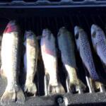
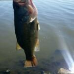
The primary target here is Rainbow Trout, stocked regularly by the Arizona Game and Fish Department from spring through fall. However, the lake also holds populations of Largemouth Bass and Sunfish, providing variety for those willing to switch tactics. The unique topography of the Mogollon Rim—pronounced locally as "muggy-own"—creates a dramatic backdrop where the Colorado Plateau drops off into the Tonto Basin. This geological positioning not only provides spectacular scenery but also dictates the local weather patterns, which are the primary logistical challenge for any captain planning a trip to this high-altitude destination.
Access & Getting There
Reaching Willow Springs Lake requires navigating State Highway 260, a well-maintained paved artery that serves as the lifeline for the Rim Country. For anglers approaching from the Phoenix metropolitan area, the ascent from the desert floor is significant. You will be climbing from near sea level to over 7,000 feet, so ensure your tow vehicle’s cooling system is in top condition, especially during the summer months. The turnoff for the lake is located approximately 23 miles northeast of Payson. Traffic on Highway 260 can be heavy on Friday afternoons and Sunday mornings as weekend warriors migrate to and from the high country. Plan your departure to avoid these bottlenecks, aiming for a mid-week or early morning arrival to secure prime parking.
💡 Captain's Tip: Engine Performance at Altitude
Remember that at 7,600 feet, naturally aspirated gas engines lose approximately 3% of their horsepower for every 1,000 feet of elevation. Ensure your small outboard is tuned for high altitude to prevent sluggish performance when launching.
The primary boat access is located at the Willow Springs Lake Fishing and Boating Site. The launch facilities here are paved and generally well-maintained, capable of handling standard trailers. However, the ramp can become slick with pine needles and algae, particularly during the monsoon season. Because there is no fee to launch, this access point sees high volume. The parking area is spacious but fills rapidly. Experienced skippers know that arriving before dawn is not just about the bite; it is a logistical necessity to ensure you have a spot for your trailer. If the main lot is full, overflow parking can be distant, making gear transport difficult.
Weather contingencies are critical when accessing this fishery. The Mogollon Rim acts as a physical barrier that forces air masses to rise, often triggering violent, localized thunderstorms. During the summer "monsoon" season, typically July and August, electrical storms are a daily afternoon occurrence. The boat ramp is exposed, and getting off the water quickly is essential when thunderheads build. The road down to the ramp is paved but can suffer from runoff during heavy rains. Always check the forecast for the specific "Forest Lakes" area rather than general regional reports, as conditions on the rim can differ drastically from towns just a few miles away.
Shore access is available and family-friendly, particularly at the Al Fulton Point Picnic Area. For those without a boat, the shoreline near the dam and the designated fishing piers offer reasonable access to deep water. However, the terrain can be uneven with volcanic rock and pine roots, so sturdy footwear is recommended. While the access is generally wheelchair accessible, specific gradients near the water can vary. The paved paths near the main facilities are the safest bet for those with limited mobility.
Willow Springs Lake, Arizona Pre-Trip Checklist
Facilities & Amenities
Infrastructure around Willow Springs Lake is designed for the self-reliant angler. There is no commercial marina, boat rental, or fuel dock on the water. This means "negative knowledge" is vital: you must arrive with full fuel tanks, all necessary tackle, and sufficient ice. The nearest location for fuel, basic groceries, and telephone service is in the community of Forest Lakes, located approximately 2 miles east of the Canyon Point Campground. For comprehensive services, including specialized marine repair or heavy provisioning, the nearest full-service community is Overgaard, roughly 22 miles east on Highway 260. Plan your logistics so that you do not need to leave the water mid-day for supplies.
Accommodations in the immediate vicinity are dominated by United States Forest Service (USFS) campgrounds, which offer a rustic but high-quality experience. The premier option is Canyon Point Campground, situated just under 2 miles from the boat access. This facility is heavily wooded with aspen and pine, providing excellent wind protection and shade. It features 113 campsites, including 32 with electrical hookups, which is a luxury in this area. It also boasts showers and flush toilets, elevating it above primitive status. For those requiring full RV hookups and a more commercial experience, Five Lakes RV Park is located roughly 2.9 miles away in Forest Lakes Estates, offering a viable alternative for captains running larger rigs who need 50-amp service and sewer connections.
| Facility Name | Type | Distance & Sites | Key Amenities |
|---|---|---|---|
| Canyon Point | USFS Campground | 1.8 miles / 113 Sites | Showers, Electric (32 sites), Amphitheater, RVs up to 75ft. |
| Sharp Creek | USFS Campground | 10.2 miles / 28 Sites | Christopher Creek access, Tent-only & Group sites, Cooler elevation. |
| Five Lakes RV Park | Private RV Park | 2.9 miles | Full Hookups, Proximity to services in Forest Lakes. |
Another excellent option for anglers is Sharp Creek Campground, located about 10 miles away. While further from the launch ramp, it sits near Christopher Creek, offering a secondary fishing opportunity for stream trout. Sharp Creek is smaller and quieter than Canyon Point, with 28 sites spread across three loops. It is an ideal base camp for anglers who prefer a more secluded setting and don't mind a short morning drive to the launch ramp. Note that while Canyon Point accepts reservations and has some first-come-first-serve availability, these sites fill almost instantly during the summer season. Advanced booking is strongly recommended for any trip between May and September.
💡 Captain's Tip: The "No-Ice" Reality
There is no ice sold at the boat ramp or immediate lakeshore. With summer daytime highs reaching the 80s, high-quality cooler insulation is critical to keep your catch fresh. Buy block ice in Payson or Overgaard before the final leg of your drive.
Permits, Regulations & Fees
Fishing at Willow Springs Lake falls under the jurisdiction of the Arizona Game and Fish Department. All anglers must possess a valid Arizona state fishing license, which should be purchased online or at a license dealer in Payson or Heber prior to arrival. Conservation officers frequently patrol the area, checking both licenses and adherence to bag limits. The regulations are in place to ensure equitable harvest of the stocked trout population, which sees heavy pressure throughout the season.
The most defining regulation for boaters on Willow Springs Lake is the 10 horsepower motor limit. This single rule dictates the character of the fishery. It effectively bans wakeboarding, water skiing, and high-speed running, creating a safe environment for kayakers, float tubers, and small aluminum fishing boats. If your vessel is equipped with a larger main engine, you may launch, but the primary motor must be tilted up and not in use; you must propel the boat solely with a kicker motor under 10hp or an electric trolling motor. Failure to adhere to this is a common citation for visitors accustomed to larger reservoirs.
Regarding camping, strict conservation zones are enforced. No dispersed camping is allowed within 1/2 mile of the lake. This rule is strictly enforced to protect the water quality and shoreline vegetation. Anglers wishing to camp must use the designated campgrounds (Canyon Point, Sinkhole, or Sharp Creek) or find dispersed camping areas well outside the restricted buffer zone on the National Forest land. Respecting these boundaries is essential for maintaining access privileges. Additionally, be aware of "Kapu" or general respect for the land; the Mogollon Rim has historical significance, and leaving no trace is not just a suggestion but a requirement for the sustainability of this high-traffic area.
Events & Seasonal Information
The rhythm of Willow Springs Lake is dictated by the stocking truck and the weather. The prime fishing season runs from late spring, as the ice melts, through late autumn. The Arizona Game and Fish Department stocks the lake regularly during these months. Savvy anglers track the stocking schedule, as the days immediately following a plant often yield high catch rates, although the fish may be smaller stockers. For trophy hunters, the "holdover" trout—those that survive the winter or evade capture for several months—are the real prize, often found in deeper water during the shoulder seasons of early spring and late fall.
💡 Captain's Tip: The Monsoon Clock
During July and August, the "Monsoon Clock" is real. The wind typically switches and intensifies by 10:00 AM, and dangerous lightning storms often form by 1:00 PM. Plan your day to be off the open water by early afternoon.
Summer brings a distinct daily pattern. Mornings are typically calm and crisp, offering the best conditions for topwater fly fishing or casting lures. By mid-morning, the temperature differential between the rim and the desert floor generates significant breezes. While there are no major professional tournaments held on this small water, the lake is a favorite for local club derbies and family competitions. Winter access is dictated by snow levels; while the lake is open year-round, Highway 260 and the access roads can be treacherous or closed during winter storms, and the lake does freeze, offering ice fishing opportunities when conditions permit safe ice thickness.
Contact Information & Resources
For the most current information regarding facility status, fire restrictions, and campground availability, the primary point of contact is the Apache-Sitgreaves National Forest. The Black Mesa Ranger District manages this area and can provide real-time updates on road closures or bear activity. For specific questions regarding Canyon Point Campground, direct lines are available, but online reservation portals are the most reliable method for securing a site.
Safety in this remote environment is ultimately the responsibility of the captain. Cell phone service can be spotty to non-existent in the dips and valleys of the rim country. It is advisable to file a float plan with someone on shore. Emergency medical services are dispatched from Payson or Heber, meaning response times can be significant. Always carry a basic first aid kit and be prepared for rapid temperature drops, even in summer. Hypothermia is a genuine risk for anglers who get wet during a summer storm and are exposed to the cool high-altitude wind.
For precise locations of the boat ramps, detailed depth contours, and real-time weather conditions, consult the live dashboard and interactive maps below.


Leave a Reply